|
| | | |
| |
|
| Hike & Climb | 21.00 Miles |
4,000 AEG |
| | Hike & Climb | 21.00 Miles | 14 Hrs 20 Mns | | 1.47 mph |
| 4,000 ft AEG | | | | |
|
|
|
| Lead II G • Trad • 5.10a Other Good • 150 Feet 5 Pitches | | |
| Partners |
|
[ show ]
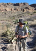
| partners | | | Pro: Double rack to BD #4, single #5 | Another day well spent chasing summit registers in the Grand Canyon. Sean, myself and Chris climbed Monument Pinnacle in route to a bit of a marathon day in the Grand Canyon.
We had to start our long day from the Waldron Trail, as we had issues with the Hermits Rest gate. This was my first time on the Waldron Trail and I really liked the short little trail, although, I would not get to really appreciate the trail until our hike out, as we started to headlamps at 3:50 in the morning. Big thanks to @john9l who helped me develop the plan B after being foiled by the gate.
We cruised to the Pinnacle, but a unique sense of dread develops in one as they cruise down a steep trail in the Canyon, for everyone knows that what goes down, must come up in the Canyon. This is a hard thought to escape when carrying heavy packs, but we tried our best to stay focused on the climb and not dwell on the second half of our day.
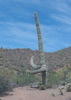
Upon reaching the majestic pinnacle of Monument Creek, little time was wasted and we were ready to start our climb. Sean drew the rope gun card again, meanwhile, Chris and I alternated between catches and wondering how the hell Sean just led a pitch.
Pitch Break Down:
1st pitch: Tricky start to stay the least, heady roof pull on a semi detached block, yard lightly friends, a stout 5.8.
2nd pitch: This is the money pitch of the climb, the beginning goes 5.11-, which we all aided (you don’t hike 10 plus miles to the bottom of the canyon to split hairs over free ascents and aid, no shame) tough varied climbing and a stout hands finish.
3rd pitch: A bit of a meh pitch, some decent climbing mixed in with soft holds and future death blocks. The semi burly mantle finish is the highlight.
4th pitch: The fourth pitch is a fun steep block party with some engaging movement and hero moves, short but sweet.
The north facing direction of our route shielded us from the sun for most of the climb, but there was nowhere to hide from the sun on the summit, so we did not stay long. Two raps will get you to the base of the climb.
The hike out was hot at times, a bit of a slog and became a little tedious the end as our anticipation for the car grew, but nevertheless, we reached the vehicle with a car to car time just over 14 hours.
36th Grand Canyon Summit. |
| _____________________
| | |
|
|
|
 Route Editor