|
| | | |
| |
|
| Hiking | 6.70 Miles |
788 AEG |
| | Hiking | 6.70 Miles | 3 Hrs 40 Mns | | 2.68 mph |
| 788 ft AEG | 1 Hour 10 Mns Break | 15 LBS Pack | | |
|
|
| |
| Linked |
|
none
[ show ]
| no linked trail guides |
| Partners |
|
none
[ show ]
| no partners | | Driving:
I took the route to the Burro Flats Trailhead via Castle Hot Springs Road from Morristown. That is a great road until the last 3.4 miles, where you turn off Castle Hot Springs main road onto Cedar Basin Road. The spur to the trail is genuinely 4WD. I would not recommend it in even a high clearance AWD vehicle. Castle Hot Springs Road via Castle Hot Springs itself is not bad either. Castle Hot Springs has recently re-opened as a $1000/night premium resort. Looked pretty popular when I drove by a couple weeks ago. Departing, just as I got back to the main Castle Hot Springs Road, I encountered a caravan of 15-20 ORVs that were headed onto the 4WD road. Except for them, the road was little used today.
If you are planning to park at Horse Creek Trailhead, the last little spur road to the trailhead is quite rough, but there are a couple of parking spots on the grass just past it and off the main road. The spur road to the Horse Creek Trailhead is easy to miss. Heading south, if you get to the top of the rise where there is a piece of galvanized drain pipe, you have gone too far.
Weather:
Today (11/7/20) is much more sunny than I expected, with clear blue skies. There was forecast for a chance of showers, and wind gusts to 20 MPH. The wind definitely came up as predicted, and the clouds came and went, but no rain.
Wildlife:
I have flushed many flocks of doves while hiking. At 3.3 miles, I heard a herd of animals. Hoping to spot several burros, I looked in all directions. Sadly, it was just cattle. I did not see any burros today. As I was driving out, I had to stop and wait for a skunk who was ambling across the 4WD road.
The Trail:
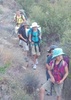
I signed the trail register and took a picture of it, and headed on my way. It is easy to miss the trail at the crossing of the first wash, just a few yards in. As you enter the wash, cross it. Don't follow it up. There really are paths everywhere. You have to pay attention to the GPS route so you don't get lost. There are cairns for the first couple miles, but not always where you need them, and not always clear.
This trail is marked as a jeep trail on the old USGS map, but it has not been one for many years. There is a large flat area at 0.8 mi that could be good for camping but for all the cattle dung. The trail is extremely gentle, no serious ups or downs. It is a little rocky. The first couple miles of trail are generally following the wash downstream. There are occasional prickly pear plants that attempted to fruit, but with this year's draught, it looks like it never fully ripened.
As you get away from the road, it becomes more "wildernsey". This is an amazing and spectacular, and secret place. Definitely around 1.6-2.0 miles is the most beautiful, awesome area of the loop. The trail crosses the wash frequently, but almost never follows in the wash itself.
At 2 miles, the trail heads down into the little canyon that hosts Burro Spring. About 100-200 yards before where the spring is marked, there is a little stream entering from the right, dry. This may be the outlet to the actual spring. When you get to the spot in the trail just below the marked spring, there is no sign of recent water.
The rocks here make amazing pictures, especially if you get here before the sun comes up over the ridge. Don't forget to look right and left for the beautiful cliffs. The biggest thing slowing you down on this trail is the catclaw, which is fierce in the section from about 1.5 to 2.4 miles.
Once through the canyon, the trail opens up, and the catclaw is much easier to dodge. While there is dung everywhere, it is mostly cattle, with some burro.
At 2.4 miles, there is a campsite. No water today, and quite a lot of dung. It appears the official trail makes a sharp left here, although the GPS track on the HAZ page continues straight down to a campsites and water hole. I stuck to the main trail and cut off a little of the loop marked on the web page. At 2.9 miles, there is an intersection where someone’s route on the HAZ page comes up the wash from the right. It looks like a serious bushwhack, though. There are campsites here and less dung. Again, around 3.5 miles, the prickly pear have tried to fruit, unsuccessfully. There is quite a lot of fruit, but it never matured.
At 3.6 miles, trail finding becomes difficult. There is a trail veering off to the right, which will ultimately head down to Garfias Wash and Hells Canyon Spring. The loop continues left. The trail is faint, and there are no cairns. You want to climb up to the canyon to your left if you are taking the Burro Flats Loop.
At 3.8 miles, there are some nice sitting rocks, a great place to break for lunch and take in the entire valley and the rocks around it. At 3.9 miles the trail suddenly and unexpectedly turns left into Horse Creek. One moment you are climbing a traverse, the next moment you are in the canyon. Shortly after passing through the remains of a barbed wire fence, the trail comes to the wash. This is one of the few places the trail follows the wash for any distance.
The crushed and split remains of the Horse Spring spring box are depressing at first, not a good sign. But just up the wash from the remains, are a couple of tiny, clear pools, with a couple of quarts in them. And further up there is a big pool. Some of it is pretty stomped by the cattle. It is flowing slowly and deep. Certainly filterable and drinkable. The box, in the middle of the wash, must have been wiped out in a summer monsoon once.
Climbing from the spring, the trail becomes the remains of a road, which must have been used for maintaining the spring box before this was wilderness. Usually, I don't like walking two-tracks, but after fighting the catclaw and dodging the cholla, it is preferable. At this point you also realize that the car is parked at the high point of this trip, and it is all uphill back to it. I don't particularly like such trails. I was raised on trails that are uphill heading into the wilderness, and downhill returning to the car.
At 4.7 miles, just when you think you are going to go over a saddle, the trail takes a sharp left turn, and takes aim for a different saddle. Looking at the map, it is clear when you go over this saddle, you will see the road. Indeed, as you head up over the rise, you are at the wilderness boundary, with an additional register. Just a long 1/2 mi walk up the road to the car from here.
I completed 5.85 miles in 3.34 hours, with no mishaps. |
  |
Horse Spring |
Dripping |
Dripping |
| | | Plenty of water. Surprising for this time of year. I think you can find areas upstream of where the cows have been stomping. | | | |
|
|
|
 Route Editor