|
| | | |
| |
|
| Hiking | 8.00 Miles |
1,100 AEG |
| | Hiking | 8.00 Miles | | | |
| 1,100 ft AEG | | | | |
|
|
| |
| Linked |
|
none
[ show ]
| no linked trail guides |
| Partners |
|
[ show ]
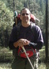
| partners | | This past August I went to Springerville for a week to organize and try to get rid of a lot of stuff out of my old self-storage unit. A friend, Deb, from Flagstaff showed up and shared the old KOA cabin with me at Casa Malpais RV Park.*
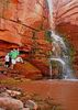
Along with another friend, Beth, who lives in Eagar, we went out to hike South Fork. We started at the main (north) trailhead, following the creek up. Crossing the creek, we hiked to the top of that crazy steep part of the trail, then retraced our steps. Before heading up the steep part, we attemped to continue up the creek trail, but gave up due to poison oak and lots of brush. When they rebuilt a burnt fence across the creek, they put the gate on the wrong side of the creek, so you can no longer easily follow the old trail. Most people never went past that gate anyway, they took the official FS trail which ends up at Mexican Hay Lake.
The last time I'd hiked here was in November 2011, about 6 months after a purposeful backburn by firefighters in this area, trying to stop the spread of the enormous Wallow Fire. It caused a lot of damage to the watershed in this little canyon. Yes, the fire in South Fork was a "backburn." I have that info from friends in the firefighting community there.
The area is recovering nicely. A nice variety of plant life has grown up, and the aspens and pines are coming in. There will be a lot more aspens than there used to be. In the long run, I think the fire was probably a good thing. Plus, there is still a lot of pine forest along the trail--it didn't all burn.
It was a gorgeous day, with nice friends. It was fun to introduce two old friends to one another, who found a lot in common.
Mileage and AEG is a guess, because I forgot to put fresh batteries into my GPS.
*Traveler hint: Cabins at Casa Malpais RV Park are the cheapest digs in Springerville under a roof, especially if you book it for a week. It was $25 per night by the week, $40 if less than a week. There are two of those old KOA cabins, with no bathrooms. They do have a fridge and a microwave, however, plus linens and towels. The RV park bathrooms are spotless, with good showers, and practically unused, because everyone is in an RV. Plenty of places to bike and walk right out the door, if you know the area. A city walking trail along the Little Colorado River is right there, plus great road biking, etc. etc. Yes, it is the same Little Colorado River that runs into Grand Canyon. |
| _____________________
There is a point of no return unremarked at the time in most lives. Graham Greene The Comedians
A clean house is a sign of a misspent life. |
| | |
|
|
|
 Route Editor