username
X
password
register
for free!
help
ArticlesGuidesRoutes
 
Photosets
 
 Comments
triplogs   photosets   labels comments more
Willow Valley - 19 members in 42 triplogs have rated this an average 4.5 ( 1 to 5 best )
1, 2, 3  Next
42 triplogs
login for filter options
Sep 21 2021
avatar

 Guides 3
 Routes 202
 Photos 3,513
 Triplogs 530

male
 Joined Jan 24 2016
 Arizona
Willow ValleyPayson, AZ
Payson, AZ
Canyoneering avatar Sep 21 2021
MountainMattTriplogs 530
Canyoneering3.37 Miles 880 AEG
Canyoneering3.37 Miles
880 ft AEG25 LBS Pack
 
Linked   none no linked trail guides
Partners none no partners
Some afternoon Willow Valley wandering along the rim of the canyon.
Bumped a half dozen coues deer doe’s right off the bat and soon after ran into a good sized sow with her two cubs.
No elk visible until back on the highway, plenty of hunters out and about but other than that just a nice quiet evening in some special big country.
wildflower observationwildflower observationwildflower observationwildflower observationwildflower observation
Wildflowers Observation Moderate
_____________________
 
Jun 10 2021
avatar

 Routes 154
 Photos 1,505
 Triplogs 266

31 male
 Joined Jun 02 2019
 Phoenix, AZ
Willow ValleyPayson, AZ
Payson, AZ
Canyoneering avatar Jun 10 2021
LJWTriplogs 266
Canyoneering12.00 Miles 2,000 AEG
Canyoneering12.00 Miles   12 Hrs      1.66 mph
2,000 ft AEG   4 Hrs   45 Mns Break
Canyon Hiking - Non-technical; no rope; easy scrambling; occasional hand use
B - Up to light current; wading/swimming; possible wet/dry suit
III - Normally requires most of a day
 no routes
1st trip
Linked   linked  
Partners none no partners
Had never been here or to WCC proper, started with Willow Valley for an intro to the area. Brought a couple friends along and we did the conventional loop from Maxwell Tank. FR81 is solid but 81E to the trailhead requires some clearance, good tires lend peace of mind. Started out a little late, around 7:30 and went clockwise. Willow Valley and this route sort of defy language; it's like a photographer saying pictures don't do a place justice, well it's hard to explain the magic down there and I'm not sure it's possible with ordinary words.

Down from the tank along the drainage bottom is rocky but only a light bushwhack. Some poison ivy that is not worth the effort to avoid. Eventually the drainage falls away and someone has anchored a rope to a tree to help with the climb. Went down and had to come back up to get down farther north. Canyon started dry and we worked around the first pool to the west. There were three unavoidable pools where we had to get in. First two were take-your-breath-away cold. Both combine for maybe 60 yards of swimming. Brought a float to ferry packs and boots across. So damn fun but took a lot of time, especially the pre-swim beers we needed to work up the excitement to get in with the cool morning air.

After the pools the canyon dries up a little before getting wetter and wetter. No more swimming, but our feet stayed wet the whole time. More and more fish and marshy areas where the grass grows over the flowing water. Absolutely sublime. Lots of wildlife, including a black rattlesnake I didn't notice until I'd stepped over it and it got to rattling. Nothing for noise but the whisper of wind and clicking of insects in the firs. Amazing mixed forest of old, huge conifers and deciduous trees that escape my taxonomic knowledge. Some use trails, some creek. It's quite slippery on the bottom and slow going. More numerous and bigger fish closer to Clover Canyon and WCC. Good campsites in the many bends. Diverse scenery along the way and around every corner.

Maxwell trail is flagged with orange tape in the trees and some cairns. It's in great shape and by then we were happy to have a trail. Cut between the roads through the hordes of cows back to the car and made it just as the sun set. Didn't see anyone on the hike, register indicated no one for three days. One car parked by Maxwell trailhead was the only sign of human life. Going back I'd backpack so as to be in no rush. No fewer than twelve hours will do, even if it could be done faster.
wildflower observationwildflower observationwildflower observationwildflower observationwildflower observation
Wildflowers Observation Isolated

water 1 out of 5water 2 out of 5water 3 out of 5water less than max Maxwell Tank 51-75% full 51-75% full
  13 archives
Aug 02 2020
avatar

 Guides 1
 Routes 269
 Photos 613
 Triplogs 1,360

50 male
 Joined Dec 22 2003
 Tucson, AZ
Willow ValleyPayson, AZ
Payson, AZ
Canyoneering avatar Aug 02 2020
RedwallNHopsTriplogs 1,360
Canyoneering10.00 Miles 1,200 AEG
Canyoneering10.00 Miles
1,200 ft AEG
 no routesno photosets
1st trip
Linked   none no linked trail guides
Partners none no partners
First time. Perfect day and a great non technical canyon. I actually brought my shorty wetsuit in case I was intimitaded by thew swims but didn't use it. We went for the "5.1" climbs to avoid the first to pools for fun. Bit the bullit on the third - wasn't too bad. Glad I didn't bother with the wetsuit. Rest of the canyon down to clover was really nice. Did the road walk from the top of the Maxwell trail
_____________________
 
Jul 12 2020
avatar

 Guides 12
 Routes 192
 Photos 863
 Triplogs 356

42 male
 Joined Nov 30 2015
 Phoenix, AZ
Willow ValleyPayson, AZ
Payson, AZ
Hiking avatar Jul 12 2020
ShatteredArmTriplogs 356
Hiking6.00 Miles 1,000 AEG
Hiking6.00 Miles   4 Hrs   1 Min   1.71 mph
1,000 ft AEG      30 Mns Break
 no routesno photosets
1st trip
Linked   linked  
Partners none no partners
Wanted to play in the water with the hot forecast. Decided to check out the Flatrock Tank route. The trail was a bit tricky to find (the description said due west, it was more like WNW), but once it appeared, it's straightforward all the way down. A bit scrambly in parts, but nothing that can't be done while holding a beer (I know this for a fact).

Went a mile or so upstream until the trail was harder to find, and then a mile or so downstream the other way towards Clover Canyon. Really nice stretch of canyon. Found some really cool wind formations in the sandstone, too. Threatened to rain most of the day, with sprinkles here and there and occasional thunder in the distance.

The hike back out is steep but short. A few minutes after getting to the car, the deluge started. Perfect timing.

Still one of my favorite canyons in Arizona.
_____________________
 
Jun 20 2020
avatar

 Guides 2
 Routes 127
 Photos 1,478
 Triplogs 129

male
 Joined May 07 2019
 Tempe, AZ
Willow Valley, AZ 
Willow Valley, AZ
 
Hiking avatar Jun 20 2020
mikemcgTriplogs 129
Hiking11.57 Miles 3,785 AEG
Hiking11.57 Miles   9 Hrs   20 Mns   1.73 mph
3,785 ft AEG   2 Hrs   38 Mns Break
 
1st trip
Linked   linked  
Partners none no partners
Route Scout Route Recorded  on Route Scout | Pop | Map | Popup | MapDEX
Our original plan was thwarted by the Bush fire, so we chose to explore Willow Valley, and I'm glad we did! We parked one vehicle at the top of the Maxwell trail, then drove the other one to the Maxwell tank to skip the 3 miles of walking on the forest road. High clearance is definitely required toward the end! It got a little bumpy but not too bad.

The descent from the road to the creek at Maxwell tank is fairly easy. We followed the wash down, watching out for poison ivy, which was present but avoidable. There's a 10 foot drop toward the end, but it was easily climbed down at the left corner, while others in our group went out of sight to the right and found a way down over there. The views and sounds in the canyon are amazing, with the high canyon walls, the many colors, the sun peeking in, and the echoes of the birds as well as our voices.

There was no water in the canyon initially, but we soon encountered 4 deep pools, each about 20-30 yards long, and crossed them in tubes, although one nimble member of our group was able to climb around all 4 of them on the right without getting wet. The water was a little chilly at first but we quickly adapted and enjoyed it.

We then took our time enjoying the views of the canyon. There was a lot of fun rock hopping. The views were amazing throughout, and the pics don't fully capture the experience. I think it was about 8 miles total in the canyon, but all of our GPSs recorded approximately 11 miles. As we went further, more water was present, and eventually the creek was continuous. There were a lot of beautiful swimming holes, but they were easy to go around for those who wanted to avoid them.

About 5 miles in, the canyon widened a little, and we started seeing a few campsites. There were well-worn use trails along the sides at this point, which made the trek much easier, but they were really thorny at times, and there were numerous poison ivy patches (or individual plants) to avoid. It got a little gnarly carrying my tube through the vegetation!

The Maxwell trail to the top was great. It was nice to be on a well-defined trail after all the rock hopping and thorns! That part went pretty quickly.

Overall a beautiful canyon, clear water, awesome people, good times!
wildflower observationwildflower observationwildflower observationwildflower observationwildflower observation
Wildflowers Observation Light
Beautiful yellow flowers in patches. I didn't get any pics of them...
  4 archives
Aug 13 2017
avatar

 Guides 1
 Routes 15
 Photos 520
 Triplogs 38

46 male
 Joined Oct 01 2005
 Queen Creek, AZ
Willow ValleyPayson, AZ
Payson, AZ
Canyoneering avatar Aug 13 2017
adv_trevTriplogs 38
Canyoneering6.50 Miles 760 AEG
Canyoneering6.50 Miles   4 Hrs   30 Mns   1.44 mph
760 ft AEG13 LBS Pack
 no routes
1st trip
Linked   none no linked trail guides
Partners none no partners
I got a late start to this hike, around 11. I headed down the canyon and it was thick with locust trees. At the bottom of the canyon I arrived at 10+ foot drop off. I was able to get down without a rope, but it was a little tricky. The rest of the hike was a lot of fun bolder hopping and swimming. I saw a bear cub and heard the momma. I'm not sure where they went, but I followed the down the canyon for at least a half hour, hearing a growl every 10 minutes. Shortly after that, the sky stated to turn. Being that I am solo, there is a mamma best and cub, the monsoons, and I still had to ride my bike out, I decided to cut the hike short and climb out of the canyon. I found some deer and elk sign, so I tried to follow their path. That didn't happen! I ended up doing a little rock climbing and cactus grabbing, but I make it out and found a road to follow back. It was an awesome hike and I will definitely come back.
wildflower observationwildflower observationwildflower observationwildflower observationwildflower observation
Wildflowers Observation Isolated
_____________________
 
Jul 22 2017
avatar

 Guides 13
 Routes 38
 Photos 1,651
 Triplogs 577

60 male
 Joined Nov 15 2005
 Jackson, CA
Flatrock Tank TrailPayson, AZ
Payson, AZ
Canyoneering avatar Jul 22 2017
toddakTriplogs 577
Canyoneering6.00 Miles 800 AEG
Canyoneering6.00 Miles   6 Hrs      1.00 mph
800 ft AEG
Canyon Hiking - Non-technical; no rope; easy scrambling; occasional hand use
B - Up to light current; wading/swimming; possible wet/dry suit
 no routes
1st trip
Linked   linked  
Partners partners
t282828
Not an easy "trail" to get to (rough roads, not a lot of road signs, muddy spots if wet), but it drops you into an excellent stretch of canyon, and WCC is always worth the effort. Went downstream to the Clover Creek confluence, then back upstream a ways until thunder and rain convinced us to head back out.
_____________________
  1 archive
Jun 17 2017
avatar

 Guides 3
 Routes 202
 Photos 3,513
 Triplogs 530

male
 Joined Jan 24 2016
 Arizona
Willow ValleyPayson, AZ
Payson, AZ
Canyoneering avatar Jun 17 2017
MountainMattTriplogs 530
Canyoneering16.27 Miles 1,350 AEG
Canyoneering16.27 Miles1 Day   4 Hrs   36 Mns   
1,350 ft AEG55 LBS Pack
 
Partners partners
chumley
JoelHazelton
Ol Chums already gave the meat and potatoes about this hike so I'll just add my little side.
I am currently typing this triplog with the worst poison ivy rashes I've ever had!
Legs, forearms, shoulders, back and even a few areas where the sun doesn't shine were also affected! :o

I also made this my first ever backpacking trip hiking in sandals which ended up being the worst idea ever!
I used a pair of Coleman brand teva style sandals that completely failed for me, the awkward foot positions, constant boulder hopping and swimming proved to be too much for the straps to hold.
I found myself constantly adjusting them to stay on and even had to wrap bungee cords around them which finally kept them in position.
The aftermath may be the worst part though because I'm almost certain I now have a stress fracture in my metatarsals due to the improper footwear and heavy weight.

Also to mention my backpack strap almost completely ripped off but luckily Chumley went into full Mcgyver mode and weaved some paracord from the strap to the frame which fortunately held up the remainder of the trip.

Regardless of the gear failures and poison ivy the beauty and silence within the canyon made me forget about all of that!
Even though Willow Valley itself is not necessarily in a remote area the canyon bottom feels very isolated and was completely filled with signs of wildlife.

I encountered more piles of bear scat than I've ever seen, all that's was missing was the bear which we still haven't came to the conclusion as to what animal we passed that was decomposing in a section of the creek.
It was just a large black mass wasting away in shallow water which filled the air of a quarter mile radius with the stench of rotted flesh.
Needless to say as the hike and heat went on a totally forgot about it and found myself drinking unfiltered creek water until Joel questioned my sanity. :sweat:

I definitely underestimated just how idyllic and impressive this canyon was and will most certainly find myself coming back here one day!
wildflower observationwildflower observationwildflower observationwildflower observationwildflower observation
Wildflowers Observation Light

water 1 out of 5water 2 out of 5water 3 out of 5water 4 out of 5 Maxwell Tank 76-100% full 76-100% full
_____________________
 
Jun 17 2017
avatar

 Guides 94
 Routes 840
 Photos 22,055
 Triplogs 1,993

52 male
 Joined Sep 18 2002
 Tempe, AZ
Willow ValleyPayson, AZ
Payson, AZ
Canyoneering avatar Jun 17 2017
chumleyTriplogs 1,993
Canyoneering14.27 Miles 1,200 AEG
Canyoneering14.27 Miles1 Day   4 Hrs   36 Mns   
1,200 ft AEG
Canyon Hiking - Non-technical; no rope; easy scrambling; occasional hand use
B - Up to light current; wading/swimming; possible wet/dry suit
III - Normally requires most of a day
 
1st trip
Linked   linked  
Partners partners
JoelHazelton
MountainMatt
This one has been on the list for a while, and Joel and I have been doing creek backpacks at this time of year for the past few years. The weather was perfect for this ... a little warm everywhere, but absolutely ideal to be swimming and wading in a deep canyon.

A couple of things to note. As others have described, the trip down the drainage from Maxwell Tank, while relatively short, is overgrown with uncomfortable prickly things. What apparently nobody else mentioned is that this drainage is choked with unavoidable poison ivy. I mean like the fields of poison ivy. If poison ivy could be harvested for food, this canyon alone could eliminate hunger across the globe. Forever. :scared:

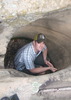
Once into Willow Valley we arrived at the first swimmer which may have been able to be bypassed on the right, but we knew we'd be swimming at some point so we just decided to get it over with. There ended up being four swimmers, and though it was a warm and sunny day, I can't oversell how cold these pools were. Absolutely full-body numbing cold. It was refreshing for about 30 seconds and after that it was a race to get to the other side. If I'm ever up here on a day that is under 85 degrees, I'd consider a wet suit for these.

After the swimmers, it's just wading and sloshing through water or along the shore and enjoying the countless amazing views in this incredibly scenic canyon. The farther down canyon you get the more space there is for camping and bypass trails along the shore. From the highest springfed pool where the water became constant to the confluence with Clover and WCC, there is a reasonably easy to follow use trail. This trail also reintroduces poison ivy, which was largely absent for a few miles, though it's a bit more avoidable than it was in the drainage leading into the canyon.

Things weren't too bad in the canyon, but up on the rim both before and after the hike, the bugs were relentless. Gnats, see-ums, no-see-ums, hear-ums, black flies, horseflies, dragonflies, elkflies, mooseflies, and baby chucpacabra larvae all feasted despite my skin glowing yellow with 106% pure deet. As I write this, I'm honestly not sure which welts are poison ivy and which are bug bites. Interestingly, there were no mosquitos. But I'm going to start breeding bat colonies to bring with me if this kind of thing ever happens again. ](*,)

Despite that, it was a fantastic weekend, and I'd do it again next week without thinking twice! :)

water 1 out of 5water 2 out of 5water 3 out of 5water less than max Maxwell Tank 51-75% full 51-75% full
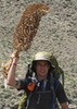
A skunky tank with cattle pooping in it. Gotta be a better option if you're thirsty.
_____________________
I'm not sure what my spirit animal is, but I'm confident it has rabies.
  1 archive
Jul 09 2016
avatar

 Guides 94
 Routes 840
 Photos 22,055
 Triplogs 1,993

52 male
 Joined Sep 18 2002
 Tempe, AZ
Tramway Maxwell LoopPayson, AZ
Payson, AZ
Hiking avatar Jul 09 2016
chumleyTriplogs 1,993
Hiking11.46 Miles 1,192 AEG
Hiking11.46 Miles   6 Hrs   38 Mns   2.25 mph
1,192 ft AEG   1 Hour   32 Mns Break
 
Partners partners
Blanco
John9L
LindaAnn
Looking for a short day trip to cool off in the clear water of WCC we decided on the Tramway Maxwell Loop. Knowing this was an ideal summer hike for pups, I decided to dognap Cup and Blanco and give them a little exercise in the woods.

Turned out to be a great day. The WCC portion of the trail was more overgrown than I remember with less of a developed route to follow. Especially upstream of Maxwell. But once we reached Willow, there was a surprisingly good use trail most of the way. I actually found this area of canyon to be much more scenic and interesting than the upper WCC part. I'll have to come back and try the loop from farther up that hits the cold swimmers.

There was a lot of algae on the rocks and underwater footing was as slippery as I can ever remember it being. And Willow has a ton of poison ivy. Rumor has it 9L is currently working on his 14th application of Tecnu since arriving home! :)
 Geology
 Geology [ checklist ]
[ checklist ]  Tafoni
_____________________
I'm not sure what my spirit animal is, but I'm confident it has rabies.
 
Jul 09 2016
avatar

 Guides 110
 Routes 2,246
 Photos 8,982
 Triplogs 2,600

45 female
 Joined Dec 24 2007
 Ahwatukee, AZ
Tramway Maxwell LoopPayson, AZ
Payson, AZ
Hiking avatar Jul 09 2016
LindaAnnTriplogs 2,600
Hiking11.71 Miles 1,198 AEG
Hiking11.71 Miles   6 Hrs   42 Mns   2.27 mph
1,198 ft AEG   1 Hour   32 Mns Break
 
no photosets
1st trip
Partners partners
chumley
John9L
I had one free day this weekend, and Chumley invited me to join in on a hike to WCC. I hadn't done the Tramway-Maxwell loop in more than ten years, so I was happy to tag along.

It was a warm hike from the road down to the creek, so as soon as I saw water, I was happy to jump in. It was not nearly as cold as I expected it to be. Good thing too, because there was plenty of time spent wading through the water on this one. The vegetation was very overgrown--more so than I could ever remember seeing down there. We made our way through the brush, and the creek when necessary. Even though the rocks were very slick, with poles, I thought it was easier to walk through the water than the brush.

After a stop for lunch, we headed up Willow. I thought the scenery in Willow was great, and the path was better. At times, it felt like walking through marshland, and was very easy to get through. We passed a few small caves/alcoves that looked like they would be great places to camp. I think Chumley aimed to walk through every patch of poison ivy in the canyon, maybe just to see if we'd follow him though it.

We found some slightly better paths in a few places on the way back to Maxwell. The climb out felt harder than I expected it to be--maybe because my shoes were soaked through, and each step I took felt like I had a five pound weight attached to each ankle.

Fun day, and perfect weather to spend down in the creek. And it was nice to run into Joe & Bruce at the gas station in Payson--nice to meet both of you!
_____________________
Stop crying and just go do the hike.
 
Jul 09 2016
avatar

 Guides 6
 Routes 183
 Photos 5,612
 Triplogs 1,647

male
 Joined Mar 12 2004
 Scottsdale, AZ
Tramway Maxwell LoopPayson, AZ
Payson, AZ
Hiking avatar Jul 09 2016
John9LTriplogs 1,647
Hiking11.46 Miles 1,192 AEG
Hiking11.46 Miles
1,192 ft AEG
 no routes
Partners partners
chumley
LindaAnn
Nice day out in WCC. The canyon never disappoints and this was another wonderful trip.
_____________________
  1 archive
Jun 30 2013
avatar

 Guides 107
 Routes 249
 Photos 2,067
 Triplogs 514

male
 Joined Nov 18 2005
 Phoenix, AZ
Willow ValleyPayson, AZ
Payson, AZ
Canyoneering avatar Jun 30 2013
nonotTriplogs 514
Canyoneering9.80 Miles 850 AEG
Canyoneering9.80 Miles   6 Hrs   45 Mns   1.45 mph
850 ft AEG18 LBS Pack
Canyon Hiking - Non-technical; no rope; easy scrambling; occasional hand use
B - Up to light current; wading/swimming; possible wet/dry suit
III - Normally requires most of a day
 
Linked   linked  
Partners none no partners
Tried to escape the Valley heat, but was still hot up north until 10PM and hot again by 9AM the next day. Hiked to the tank and headed down the drainage. A little brushier than anticipated, but not terrible. WCC is dry where you first reach it, but there are several initial pools of ice water you have to swim through. Awfully refreshing considering the heat. As you boulder on you eventually run into water. First a little, then it finally starts flowing. Still missed the arch toddak posted. :( Once you reach the flowing creek it is awesome the rest of the way. Headed up the maxwell to breezier weather and cooler temps on Saturday night.

water 1 out of 5water 2 out of 5water 3 out of 5water less than max Clover Creek Medium flow Medium flow
typical flow into WCC as compared to past years.

water 1 out of 5water 2 out of 5water 3 out of 5water less than max Maxwell Tank 51-75% full 51-75% full
more than half full, not horrible looking
_____________________
http://hikearizona.com/garmin_maps.php

Hike Arizona it is full of sharp, pointy, ankle-twisting, HAZmaster crushing ROCKS!!
Hike Arizona it is full of sharp, pointy, shin-stabbing, skin-shredding plants!
Hike Arizona it is full of striking, biting, stabbing, venomous wildlife!
 
Nov 24 2012
avatar

 Photos 19
 Triplogs 2

42 male
 Joined May 09 2012
 Paradise Valley,
Willow ValleyPayson, AZ
Payson, AZ
Canyoneering avatar Nov 24 2012
Slinger05Triplogs 2
Canyoneering6.50 Miles 760 AEG
Canyoneering6.50 Miles1 Day         
760 ft AEG35 LBS Pack
Canyon Hiking - Non-technical; no rope; easy scrambling; occasional hand use
B - Up to light current; wading/swimming; possible wet/dry suit
II - Normally requires a half day
 no routes
1st trip
Linked   none no linked trail guides
Partners none no partners
The service road to get to the trail took at least an hour. We traveled by truck which is highly recommended for this trail. We arrived after sunset and had to do some night driving for at least 30 minutes. It was cold..very cold in November. I remember scrambling to find wood so we could get a fire going asap.

The trail down the canyon was a little difficult to find without a waypoint. Once you find the trail marker/head it's an easy way down and it's almost impossible to go off the trail. It was quite a hike down but the views are amazing. I'd say it took about 1/2 hour to get to the bottom and about 45 minutes to climb/hike up.

We parked at MGRS: 12S VD 6282 2369 which is about as close to the trail as possible.

There's was little water at the bottom from where we ended up. I'm thinking we were either at the end of the trail.
_____________________
 
Jul 31 2011
avatar

 Guides 3
 Routes 4
 Photos 8,687
 Triplogs 931

46 male
 Joined Mar 28 2005
 Gilbert, AZ
Shamrock CanyonPayson, AZ
Payson, AZ
Canyoneering avatar Jul 31 2011
VapormanTriplogs 931
Canyoneering8.00 Miles 1,000 AEG
Canyoneering8.00 Miles   9 Hrs   45 Mns   0.82 mph
1,000 ft AEG
Intermediate Canyoneering - Difficult or dangerous; Tech Climb; rope reqd; descent anchor; exit technical;
A - Dry or little water; shallow or avoidable water; no wet/dry suit
II - Normally requires a half day
 no routes
Linked   linked  
Partners none no partners
Well I was a little tired from hitting Horsetank Wash the day before but a cute gal talked me into another canyon up on the rim. I choose Shamrock since it was the only WCC canyon I hadn't done already this summer and I felt I could safely get her down canyon with no issues with her limited canyon experience. :)

That 142F is marked well this summer, so making my way up it in my car wasn't a problem at all. After driving a few miles up that road, I parked at a junction near the exit canyon and dropped down east into Shamrock canyon. It's a tad higher up canyon than in Todd's book, but it's a gentle slope and you get to see more of the lush scenic canyon and I get to test out more of her down climbing skills before reaching the main technical narrows. ;) We encountered loads of mossy down climbs, some small narrows that we bypasses, and loads of canyon stew before reaching the first optional rappel. I could of down climbed that initial 10ft drop but no point taking the risk with her and being on rope made it easier to avoid that stinky keeper pothole. And I was able to use the rope to help keep her out of it also. :D The water is only waist deep in a few sections and it's the middle of summer so I opted to forgo the wetsuits but that also meant out skin took more of a beating on the down climbs & pesky vegetation. : rambo : This is soon followed by a mossy chute that requires a controlled slide to land on some submerged logs to avoid getting completely wet. After going thru another vegetated narrows, you hit the first bolted rappel of about 30ft into a waist deep pool with another bolt on the right. Pull ropes and re-rig for at least 100ft of rope both sides so you can get you about 50ft down into the hallway, across that pools, and if you want to avoid the keeper you lean hard right LDC past the arch and over the fin of sandstone. She's not ready for a keeper and I didn't want to carry more than 200ft of rope, so I figured this was the best setup for us. :) Another 30ft log-choked rappel is just around the corner with another 60ft open drop just beyond that. Below is a great sunny spot for lunch and to drop the technical gear before bushwhacking your way to the beautiful West Clear Creek. :D

The technical canyon is short so I recommended we venture up the scenic Willow Valley for a couple hours. It was of course as amAZing as ever with it's many cool swimmers, tall colorful sandstone walls, and lush vegetation. We got a good 2-3 miles upstream before turning around and heading back to WCC. Back at the confluence, we picked up our technical gear and headed downstream a bit for the steep exit canyon. The exit was of course steep and full of more poison ivy & stinging nettle but we were able to avoid most of it thankfully. ;) It was SO nice to be done with that sweaty steep hike out of WCC with less than an hour of light left. :sweat:
_____________________
Yea, canyoneering is an extreme sport... EXTREMELY dramatic!!! =p
 
Jul 22 2011
avatar

 Photos 35
 Triplogs 15

male
 Joined Sep 09 2010
 Mesa, AZ
Willow ValleyPayson, AZ
Payson, AZ
Canyoneering avatar Jul 22 2011
metalmansion81Triplogs 15
Canyoneering8.50 Miles 760 AEG
Canyoneering8.50 Miles   7 Hrs      1.21 mph
760 ft AEG
Basic Canyoneering - Scrambling; easy climbing/downclimbing; frequent hand use; rope recommended; easy exit
B - Up to light current; wading/swimming; possible wet/dry suit
III - Normally requires most of a day
 no routes
1st trip
Linked   linked  
Partners none no partners
Took Friday off work and drug a friend along to check out another non-technical canyon up on the rim. Cached some water at the Maxwell trailhead and drove over to the Maxwell tank to drop in. Willow Valley starts of as a pretty nasty bushwhack down a small drainage, but soon opened up into an awesome Coconino sandstone canyon. A few short down climbs to the valley floor and a few minutes of boulder hopping brought us to the first of the 3 swims. Looked for the climbing route to the right mentioned in Canyoneering Arizona, but didn't find anything promising, so we sucked it up and got in the COLD water! We motored through the 3 swimmers quickly and got to boulder hopping through the gorgeous sandstone narrows to warm back up.

Once the valley opened up and the creek showed up it was back to bushwhacking on one side of the creek or the other or wading down the middle. At times the vegetation was very dense and left any exposed skin looking like a gang of alley cats attacked us, one plant we brushed by made us itch like crazy till we rinsed off in the creek. Stinging nettles maybe? Those creek miles feel so much longer than normal miles and it felt like took way too long to get to the Maxwell Trail, but it finally showed up.

We hiked up the Maxwell trail with only a small amount of water left and were very happy to have cached that gallon for the 3 mile road walk back to the truck. Awesome weather all day and a fun canyon. Can't wait to explore further down in WCC and see the White Box and Hanging Garden I keep hearing about!
_____________________
 
Jul 02 2011
avatar

 Photos 32
 Triplogs 470

male
 Joined Nov 05 2006
 Chandler, AZ
Willow ValleyPayson, AZ
Payson, AZ
Canyoneering avatar Jul 02 2011
AHOTETriplogs 470
Canyoneering8.50 Miles 760 AEG
Canyoneering8.50 Miles
760 ft AEG
 no routesno photosets
Linked   none no linked trail guides
Partners none no partners
Plus walk back on the road.
_____________________
  1 archive
Apr 16 2011
avatar

 Guides 3
 Routes 4
 Photos 8,687
 Triplogs 931

46 male
 Joined Mar 28 2005
 Gilbert, AZ
Willow ValleyPayson, AZ
Payson, AZ
Canyoneering avatar Apr 16 2011
VapormanTriplogs 931
Canyoneering20.00 Miles 1,500 AEG
Canyoneering20.00 Miles1 Day   3 Hrs      
1,500 ft AEG
Canyon Hiking - Non-technical; no rope; easy scrambling; occasional hand use
B - Up to light current; wading/swimming; possible wet/dry suit
III - Normally requires most of a day
 no routes
I was looking for non-technical overnighter up on the rim to just getting away from it all and mid-April is usually when all the rim roads re-open so I figured I'd drive up and see how much snow was left and which roads I could access and was pleased to see no snow and the roads pretty much all re-opened. :y:

I worked that Saturday morning, but I drove up that afternoon and got a few miles in on FR142 before parking and beelining across the rim towards middle Tom's Creek and dropped in via a steep side drainage. It'd been SO long since I'd been in WCC that I was quickly enchanted by even a hint of the sandstone goodness yet to come. :D Followed Tom's Creek downstream to its confluence with Clover Creek and continued on to the confluence with Willow Valley and the beginning of WCC and setup camp at a sweet campsite nearby. Nice, it only took 3 hours of scenic rock hopping to get here. :sweat: Heated up a Mountain House, rolled out my bag & pad, made a small fire, watched as the full moon lit up the canyon thru the clouds, and listened to the many canyon sounds. ;)

Woke up early the next cool morning, did the morning rituals, and made an early trek up Willow Valley to the 'springs'. The morning stayed cool and the water was chilly, so I avoided the creek when possible and stuck to less scenic side trails. The deciduous trees and ferns and grass haven't all grown back yet with much evidence of some massive winter flows that rushed thru here, but Willow Valley was still just as amAZingly beautiful as she ever is. :D On the way up, I saw a handful of geese and even a few elk grazing down in the creek. Once at the springs, I chilled at took a lunch break & power nap before returning downstream and taking loads more photos in the better light. At the confluence & back at camp, I packed back up my full backpack and by then I'd decided I wasn't going to return the way I came in but instead continue down WCC and exit up 142E trail and walk 142 back to my car. :sweat: It's been a few years since I'd hiked straight thru this part of WCC so I was kinna surprised and how close every thing was together. :lol: Before I knew it I was passing the Maxwell trail, Tramway trail, the springs and Sundance Canyon already?!? :o I crossed the waist hike chilly creek to enter the Cathedral of lower Sundance Canyon as was treated with the lightly trickling 180ft falls and a 6th high ice/snow mound at the bottom. After checking that out, I continued around the corner and up the 142E trail and was pleased that I'd still have plenty of light for the LONG road walk back to my car. :sweat:

WOW, West Clear Creek always has a way of blowing my mind every spring/early summer with it's amAZing beauty and I can't wait to start canyoneering here again. :y:
 Fauna
 Fauna [ checklist ]
[ checklist ]  Elk
_____________________
Yea, canyoneering is an extreme sport... EXTREMELY dramatic!!! =p
 
Aug 14 2010
avatar

 Guides 13
 Routes 38
 Photos 1,651
 Triplogs 577

60 male
 Joined Nov 15 2005
 Jackson, CA
Willow ValleyPayson, AZ
Payson, AZ
Canyoneering avatar Aug 14 2010
toddakTriplogs 577
Canyoneering16.00 Miles 2,000 AEG
Canyoneering16.00 Miles   10 Hrs      1.60 mph
2,000 ft AEG
Canyon Hiking - Non-technical; no rope; easy scrambling; occasional hand use
B - Up to light current; wading/swimming; possible wet/dry suit
III - Normally requires most of a day
 no routes
Partners none no partners
The bushwhack into the drainage is brutal but short, once in the bottom the going gets much easier. Great water in the creek, a bit cold on the swims but great for wading. Hiked up to the east rim via a cairned use trail (aka Flatrock Tank trail) at the top of the second straightaway that meets the rim at the end of FR9399S - steep and loose but not too crazy. Also did the Tramway Trail.
_____________________
  1 archive
Jul 16 2010
avatar

 Photos 34
 Triplogs 63

39 male
 Joined Mar 18 2008
 phoenix
Maxwell Trail #37Payson, AZ
Payson, AZ
Backpack avatar Jul 16 2010
berkforbesTriplogs 63
Backpack4.00 Miles 700 AEG
Backpack4.00 Miles3 Days         
700 ft AEG
 no routesno photosets
1st trip
Linked   linked  
Partners partners
steveforbes
Great 3day trip with my dad, sister, and her friend Kurt.

Had planned on dropping in at the Maxwell tank, but we couldnt find the trail down, so we went over to Maxwell trail instead and cut our losses. Thankfully we had camp set up by 2pm friday because once the rain started falling it didnt stop until about 7pm that evening.. It was nice chilling in the hammock under the tarp and relaxing as it rained, but it also made me a bit stir crazy.. Luckily the clouds broke saturday morning by about 10am and we got everything dried out, did some exploring and hiking up and down the canyons as well as a bit of swimming..

As for the directions in, FR81 is actually closer to 7 miles in off of Lake Mary Rd. And i would def not recommend taking a car, we didnt, but there are some decent size rocks on the road about 3 miles out from the TH that im pretty sure most cars wouldnt be able to negotiate.
_____________________
"Rather love, than money, than fame, give me truth."
-Henry David Thoreau
 
average hiking speed 1.56 mph
1, 2, 3  Next

WARNING! Hiking and outdoor related sports can be dangerous. Be responsible and prepare for the trip. Study the area you are entering and plan accordingly. Dress for the current and unexpected weather changes. Take plenty of water. Never go alone. Make an itinerary with your plan(s), route(s), destination(s) and expected return time. Give your itinerary to trusted family and/or friends.

helpcommentissue

end of page marker