|
| | | Shinumo and South Canyons, AZ | | | |
|
|
Shinumo and South Canyons, AZ
| | |
| |
|
| Hiking | 16.78 Miles |
5,526 AEG |
| | Hiking | 16.78 Miles | 3 Hrs 17 Mns | | 5.11 mph |
| 5,526 ft AEG | | 50 LBS Pack | | |
|
|
| |
| Partners |
|
[ show ]
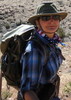
| partners | | Thanksgiving day, five hearty explorers started down the trail built in the 1950s for use for building a dam in Marble Canyon near Redwall Cavern. The trail was easy to follow and had several switchbacks so it wasn't terribly steep. There were only a couple of spots where the trail had been washed out over the years.
Soon Josh, Carole, Kevin, Kim, and I were at bed of Shinumo Wash. We barely had to do any rock hopping before we saw cairns marking the trail that continued down canyon using benches on either side to stay out of the rocky canyon bottom.
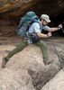
Despite carrying 50+ lb packs, we moved quickly towards our goal, the Redwall narrows! We took a lunch break in the sun before heading into the shade at the top of the narrows.
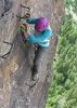
Many people think that Redwall Limestone is actually red. When in fact it has just been stained red over the years by the red Hermit and Supai layers above it. In the narrows we observed that the red had been completely scrubbed away and left behind was a silver limestone that had been polished to a gloss. Water had craved out a beautiful path down through layers of limestone to the Coloradoy River.
Water doesn't just take a straight line to get to its destination. Instead it curves and plunges along its way. And so did we...thru the Sliver Grotto.
Our first few obstacles were some down climbs. I was happy to accept assistance from the team. I was even more happy get on rope!
The rappels nearly all landed in chilly pools! Sometimes I could touch and sometimes I had to do swimming disconnects and swim across the long frigid pool to the exit. I was very thankful for my 5 mm wetsuit! Even though it was cold I felt alive! That is the feeling that keeps me coming back for more of the pure torture of cold water Canyoneering.
We completed 4-5 rappels. Each time we would inspect the anchor to see how sound it was. There were several natural anchors. There was even a couple anchors built of climbers nuts in cracks. Overall things were in good shape and we had to replace very little gear.
The water had taken a steep descent and carved out a few slides that could be negotiated without a rope. There was no angle of repose. It was quite the opposite. No matter how much friction I could apply to the polished slide my speed seemed to accelerate to maximum velocity quickly. The ride ended with a splash in the face. If I wasn't awake already, I would have been after the cold water entered my nose!
We only took one rope so it was fun to watch each of us experience all our follies! As we watched each other we danced around to keep warm.
Finally, we came to the end of the Shiver Grotto. The freezing cold will fade from my mind sooner or later. The beauty of the narrows will always remain in my mind.
We set up camp on the beach, spreading out our wet items. Happy to be warmed by our dry clothes!
As night time came, the others ducked into their tents for the night. Nighttime reminded me of my unplanned solitude. I swore I would not let my life outside the Canyon ruin my experience inside the Canyon but I couldn't help crying.
I wandered the beach with the intent to test the inReach and to have a bit of human contact from the outside. The sky was basically the shape of a human eye. I wasn't quite sure I would be able to pop off a message but finally I found a spot and sent an update of our location. Having a trusted friend know where exactly we were was reassuring. I never want to relive waiting 18 hours for help.
In the morning, we leisurely packed up camp and inflated our rafts. We were all excited to hit the River! We paddled out into the end of a rapid. There is nothing about packrafting that can leave you a frown! We had a blast paddling. There were a few riffles and a small rapid to paddle thru. I did alright in the riffles in my trusty vessel - even if it did turn into a bathtub a couple times. Carole and I could not get the courage to take on the rapid - maybe next time! Josh managed to sneak past the worst of it. While Kevin and Kim took it head on in their Alpacas.
We arrived at South Canyon and made up our camp. Then Kevin, Kim, and I made our way via raft to Vasey's Paradise. We had a goal of trying to get to Redwall Caverns, too. We headed downstream and into faster choppy water. My raft quickly filled and I fought to keep from flipping while my raft decided to go sideways and backwards! Finally, I was thru and I saw that Kevin was towing Kim's raft and her to the shore so I cut over. I think that I had a hard time because the weight of my pack wasn't in the raft with me. We decided to forget our goal so that Kim could get warmed up before dark. We hiked back to Vasey's. Then we paddled upstream a bit to below Stanton's cave and anchored our rafts. We scrambled up to get our sexy 'silowets' ( silhouette while wearing a wetsuit) in the entrance!
As we came scrambled back to our rafts we watched the NPS rescue helicopter land on the beach. We quickly finished up our paddle upstream so we could find out what was up. We were a bit nervous as our friend, Scott, was hiking in to meet us.
Exactly a year ago, Black Friday, Joel had fallen so to see the helicopter was a bit of a pause for me. When we got back to camp Josh and Carole were talking to the rescue team and had learned that they were looking for a single hiker who was section hiking the full length of the GC who hadn't checked in. The main guy was familiar and soon we were reminiscing about last year's fated trip. Matt had been our primary contact during Joel's rescue. Sadly, he asked where Joel was and I to tell him that while he was fully recovered we not going to be together any longer. I was going to be adventuring through life without him. It was impossible not to shed a tear or two.
As evening approached we kept our eyes on the hikers route and soon we saw Scott! Karl was to have come with him but later we learned he had gotten sick.
Scott came bearing gifts! To my surprise, he had a bottle of my favorite root beer, cookies, and cheese! Carole had given him some hints. Scott was a bad-ass for carrying all that and coming down South Canyon by himself!
The next morning we packed up and then went with Scott so he could check out Vasey's and Stanton's Cave.
Before we started on our way up South Canyon, a small group of cavers came by. We learned they had spent a week underground mapping a cave! Even more surprising I learned that the leader is the same person I will do a trip in the Bob Marshall with this coming summer. We had been Facebook friends for a few months and exchanged communications but had never met. What a coincidence!
We started our way out South Canyon. The hiker's route was extremely steep in places with some class 3 scrambling with our heavy packs. Watching Josh go with the rope made me not complain about my load. Not complaining was quite a feat when you consider that us canyoneers each had a wetsuit, packraft, PFD, paddles, harness ladened with hardware, helmet, and most of the usual cold weather backpacking gear.
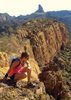
The weight of my pack was offset by the beautiful views of South Canyon all around. As we traversed above the narrows, we could peer down and see the amazing power of water!
The plan was to stop half way near some pools for the night. Scott had already scouted out a campsite on his way down. Lucky for me, Scott likes slick rock camps so it was exactly what I hoped for!
With the slick rock there was no way for me to adequately anchor my tarp. It hasn't rained all trip so I was hoping my luck would hold. My plan was to just drape my tarp over my sleeping bag if it rained. If it rained really bad then I could move my bag to a small spot under an overhang.
We hung out in camp and had the traditional sharing of all of our extra food. Then we made up hot water bottles to prepare for what was going to be a cold night. Unfortunately, it started to rain/snow. I hope it would stop but finally I had to give up and get in bed. The hot water bottle definitely kept me warm especially with the tarp laying over top of me. I drifted in and out of restless sleep. Finally, the roar of quiet made me realize it had stopped raining so I turned down my tarp so I could let the amazing amount of condensation under the tarp escape. My EMS 0 degree down bag performed admirably at keeping me dry and warm.
The last morning was by far the coldest. We could see ice on some of the shallow pools as we made our breakfast.
Our goal was to have lunch at Marble Canyon Lodge as we were jonesing for Green Chili Stew so we headed towards the Rim! Before the big climb out of the canyon we had a water and snack break. Then we started the scramble up.
Route finding going up was fairly straight forward. There were several climbs that seemed like it would be pretty scary if one was going down the trail. There was a couple times I needed either a spot or a knee in order to make it up with my bum shoulder.
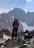
As we climbed I kept track of the layers of the Canyon. When I saw Kaibab Limestone, I knew we were nearly to the top!
When we came out on top of the Rim, I was stunned, as usual, by how flat the Rim can be. I can imagine how the first humans who saw the Grand Canyon would have felt traveling along what seems to be a vast flat surface to suddenly see it plunge over the edge into rugged canyons and cliffs.
We piled our packs on top of Scott's FJ and the six of us squeezed in. We headed towards a satisfying lunch before completing our car shuttle and then long drive home.
This trip reminds me how important friends are. Without a great team of friends this trip wouldn't have been possible! |
| _____________________
| | |
|
|
|
 Route Editor


 Before long we were at the confluence of South Canyon, where we took the backpacker's route over the dryfall and then stayed in the creek bed for the boulder hop down to the narrows. The redwall narrows of South Canyon were pretty short but very scenic with more good downclimbing. The last chockstone drop had an anchor already set up, and I have to give major props to anyone who can actually downclimb that beast(the log ramp mentioned in Todd Martin's book is gone). Was definitely glad to be wearing a wetsuit as the water in there was extremely cold, although over quickly. Made it to the beach around 2pm where we checked out the Stanton's Cave and Vasey's Paradise (thoroughly enjoyed both). Dirtbagged it that night out under the stars next to the Colorado with the almost-full moon above us. Had some crazy dreams which always seems to happen when sleeping below the rim.


 (I was later told by a doctor friend that many a scrotum had been attacked by black widows in those old wooden outhouses...YIKES)