username
X
password
register
for free!
help
ArticlesGuidesRoutes
 
Photosets
 
 Comments
triplogs   photosets   labels comments more
Barnhardt - Sandy Saddle Loop - 10 members in 20 triplogs have rated this an average 3.3 ( 1 to 5 best )
20 triplogs
login for filter options
Jun 19 2025
avatar

 Routes 39
 Photos 64
 Triplogs 42

58 male
 Joined Mar 29 2015
 Chandler, AZ
Barnhardt to Sandy saddle junction, AZ 
Barnhardt to Sandy saddle junction, AZ
 
Hiking avatar Jun 19 2025
AndrewrdcTriplogs 42
Hiking8.36 Miles 2,024 AEG
Hiking8.36 Miles   4 Hrs   42 Mns   1.96 mph
2,024 ft AEG      26 Mns Break20 LBS Pack
 
no photosets
1st trip
Partners none no partners
Route Scout Route Recorded  on Route Scout | Pop | Map | Popup | MapDEX
Thursday morning (Juneteenth) hike up Barnhardt trail to see condition of Sandy Saddle. Many years ago, sandy saddle trail almost killed me… I’ve not set foot on that trail ever since as a result. However, I saw a post from @jacobemerick the other day that he and his son had been doing some trail maintenance on Sandy saddle and I was curious to see the progress. Unfortunately, I had forgotten how challenging Barnhardt is and yesterday was the hottest day of the year (116 in Phx). By the time I got to the SS junction, I was seriously second guessing my decision. Regardless, I tried heading down SS Trail but never even made it to were Jacob had been clearing. I attempted clearing some of the trail but only had a machete to work with… really need some good, large clippers to get through the Manzanita! Sorry Jacob, I don’t think I helped very much.

After a while, I heading back up to Barnhardt and then back down the trail to the parking lot. Really beautiful day but was a bit humbled by this hike. It’s about 2,000 Aeg over less than 4 miles which was no joke on a hot day. Love the Mazatzals but always need to respect this place.

Crashed early and slept like a baby last night…

Andrew

dry Garden Seep Dry Dry
Nada...

dry Hawaiian Mist Dry Dry
No mist today... not even a puddle
_____________________
 
Jun 06 2020
avatar

 Guides 34
 Routes 138
 Photos 931
 Triplogs 111

68 male
 Joined Dec 26 2018
 Phoenix, AZ
Barnhardt - Sandy Saddle LoopPayson, AZ
Payson, AZ
Backpack avatar Jun 06 2020
GrangerGuyTriplogs 111
Backpack15.00 Miles 4,735 AEG
Backpack15.00 Miles1 Day   2 Hrs      
4,735 ft AEG21 LBS Pack
 no routesno photosets
1st trip
Linked   none no linked trail guides
Partners none no partners
I really like this area, but I get bored quickly hiking the same trails over and over. I saw the old guide of the Sandy Saddle trail. Seemed pretty complete, although it would be a challenge. I'm in decent shape for a 63 year old guy, and confident in the wilderness. How bad could it be? For me, 15 miles is 2 days, no matter what. I planned to stay in the camps near the top of the Barnhardt trail, and walk out early on day 2.

Barnhardt Trail #43
Took me about 3 hours to get to the junction with the Sandy Saddle trail, including a long stop at the remains of the falls to recharge my water. Just a few pools there. See separate water report.

Sandy Saddle Trail #231
It was no problem to find the junction with the Barnhardt Trail, and the trail is clear and easy to follow down the ridge, off the side of the ridge, and to the first little wash. Spent a little time trying to find the remains of the trail. There are cairns in the wash, but seemingly nothing like a trail on the other side. Eventually found the remains of the trail, and started pushing through.

Between the GPS track in the official log, and a good sense of trail finding, I was able to get to Casterson Seep, no water there. Finding the trail up from the seep baffled me for a long time. Eventually just crashed through the brush for a while, and eventually found the trail where it got more open, and followed it down to the next wash. Stayed in the wash until it was time to climb the ridge, and this is where the real pain began. I'm not sure if I was ever really on the trail as I climbed and climbed. This was exhausting. 3 helicopters (or 1 three times) flew over while I was doing this. Wondered what they thought of the old man out in the middle of nowhere.

Found a cairn where the trail bears right at the top of the ridge, and followed the trail down to the "deep cut". It seemed to disappear into a wall of oaks. I just dropped down and across the cut, and spent a lot of time hunting for the track on the other side. At one point, I was totally walled in by Manzanita, wondering if I would ever be seen again. But thanks to the track and the old USGS map loaded in my Garmin, which seemed pretty accurate, I was able to find the track on up to Sandy Saddle. From here, the way was easy, because I just followed the wash all the way down to the Mazatzal Divide Trail / AZT. I never even bothered to look for the trail after Sandy Saddle.

It took 6-7 hours for me to negotiate those 3 miles. Never would have made it without the GPS track. I'll have to buy a new pair of zip offs, which were ripped to shreds. I'll be having Manzanita Dreams for weeks. My calves will be bruised as well

Mazatzal Divide Trail #23
When I found this, I was in heaven. This trail is in great shape. Followed it back to Chilson Spring (good water). Had to turn on my headlamp as I arrived there, and had a nice chat with the frogs in the spring box. Continued along the AZT to a series of nice camps, just short of the intersection with the Barnhardt Trail. Saw a bunch of "cyclops spiders" in my headlamp. Very cool. Broke camp at 6:15, and headed down the

Barnhardt Trail #43
Made the best time I could heading down in 4.5 hours including rest breaks.

(Made my water reports separately).

water 1 out of 5water less than maxwater less than maxwater less than max Big Kahuna Falls - Mazatzal Wilderness Pools to trickle Pools to trickle
Just a drizzle coming down in the falls. A few pools with water. Have to climb up to the falls to find these.

dry Castersen Seep Dry Dry
Completely dry

water 1 out of 5water less than maxwater less than maxwater less than max Chilson Spring Dripping Dripping
Spring box is full of good tasting water. Both frogs and algae in the tank, but water is clear.
 
Jun 03 2018
avatar

 Guides 38
 Routes 182
 Photos 1,602
 Triplogs 232

40 male
 Joined Dec 09 2014
 Gilbert, AZ
Barnhardt - Sandy Saddle LoopPayson, AZ
Payson, AZ
Hiking avatar Jun 03 2018
jacobemerickTriplogs 232
Hiking16.98 Miles 3,810 AEG
Hiking16.98 Miles   7 Hrs   55 Mns   2.46 mph
3,810 ft AEG   1 Hour   1 Min Break
 
1st trip
Partners none no partners
Realized it is already halfway through 2018 and I haven't been in the Mazzies yet. This is a simple loop that needed no extra planning to put together.

Barnhardt #43
Started from an empty trailhead. Trail is in good shape. Waterfalls are dry. Fascinating how quickly the temps change from shivery-cold to sweaty-hot as you swing in and out of the drainages.

Sandy Saddle #231
Tried to be more conscious of following the old tread this time, confident that I had it all the way to Castersen. Brief break near the tanks before pushing up the other side, then didn't really try to follow trail again until I was going up the main ridge. Few switchbacks at the beginning that I didn't notice on my last hike. Climb seemed shorter this time (probably because I had a daypack on) and hit the saddle feeling good. Promptly stepped on an agave and the tip broke off on the inside of my foot. Wasted time on the other side of the saddle digging that out and eating some tuna before bouncing down towards the superhighway junction. Overall it can be tracked with a careful eye, a GPS definitely helps, and it will make you bleed.

Mazatzal Divide #23
Last time I hiked the section of this from Sandy Saddle to Chilson was in 2016, before some intense trail maintenance, and it is gold now. Huge views, lovely tread, just a lot of fun. There are a few prickly pears to step over, that's about it. Swung up to Chilson Spring while in the area, which is clean and full.

Barnhardt #43
This trail again? It was hot now, but I was going downhill and didn't care too much. Ran into a group of five near the waterfalls, we chatted a bit at the parking lot.

Even though I've already covered these trails it was great to get back in these mountains and try out a new loop. TBH I kept thinking about Rock Creek today, would be fun to do that loop again with these summer temps.
 Culture
 Culture [ checklist ]
[ checklist ]  HAZ - Selfie


water 1 out of 5water less than maxwater less than maxwater less than max Castersen Seep Dripping Dripping
Few tanks below still had water, though they were opaque.

water 1 out of 5water less than maxwater less than maxwater less than max Chilson Spring Dripping Dripping
Recently cleaned out, would be easy to pull water from now. Water was dripping out of the holder. Looks like the lid was intentionally removed.

dry Hawaiian Mist Dry Dry
_____________________
 
Sep 16 2016
avatar

 Routes 39
 Photos 64
 Triplogs 42

58 male
 Joined Mar 29 2015
 Chandler, AZ
Barnhardt - Sandy Saddle LoopPayson, AZ
Payson, AZ
Backpack avatar Sep 16 2016
AndrewrdcTriplogs 42
Backpack15.00 Miles 4,735 AEG
Backpack15.00 Miles2 Days         
4,735 ft AEG35 LBS Pack
 no routesno photosets
1st trip
Linked   none no linked trail guides
Partners none no partners
This was my first time out to Deadmans Falls and, in fact, my first time in the "Mazzies". The hike out on Barnhardt trail is truly spectacular... however, the trip back along Sandy Saddle trail is not for the faint of heart!

The hike up Barnhardt Trail is uphill almost the entire way, but for the most part it is gradual. The exception to this is the uppermost switchbacks which get very steep... seems like the trail got impatient and said "F" it... lets get to the top already! All in all, this was a very enjoyable hike which I look forward to doing again. My backpacking partner and I even got a surprise as we were climbing the last switchback as two F-16 fighter jets skimmed over the top of the ridge almost directly above us at surprisingly low altitude! Very cool and certainly unexpected.

Soon after passing the sign for Chilson Spring, we joined up with the Mazatzal Divide Trail and headed north. By this time we were tired but truly enjoying the sunny day and mild temps (approx 80 degrees). A mile or so on, we started seeing the gorge on our left and enjoyed the views until getting to Deadmans Falls and our campsite. Unfortunately, the falls were not running at all (as expected), but the views are still spectacular. Since we knew water would be an issue, we pretty much planned to head up to Horse Camp Seap... on our way there we found several large standing pools in the creek bed just East of the falls. We filtered all the water we would need for our stay and hike out in the morning. Had a great evening relaxing by the fire and drinking burbon. Full moon came out over the ridge to our East and lit up the plateau... stunning!

The next morning we headed east along what we expected to be Sandy Saddle Trail. To call this a "trail" is an insult to trails... there is no trail to speak of. The attached GPS route is a general direction along an overland route... I cannot possibly overstate how difficult the next three miles were. If not for the Route Scout app, my map and compass, there is no way we would have made it back to Barnhardt trail. The terrain in places is very steep along scree covered hills and in many other places we were fighting our way through thick brush UPHILL trying to find a trail or the occasional (and appreciated) cairn. My hiking buddy and I are in excellent physical condition (he is an Iron Man athlete), and this trail took all we had. By the time we found BT, we were pretty much completely exhausted and just hunkered down for the four mile hike back to the TH and our car. Im sure the scenery was just as beautiful as the day before, but cant say as I enjoyed it on the way out.

For those of you that LOVE difficult route finding over steep terrain... the Sandy Saddle route is the one for you! For those of you that think you might like the challenge... think twice about taking this trail. Seriously. This is only for the most physically fit and experienced hikers.

All in all, this was one hell of a way to get introduced to the Mazzies. Cant say as I would ever consider doing SST again, but im looking forward to getting to know some of the other trails in this range.

Andrew

water 1 out of 5water less than maxwater less than maxwater less than max Big Kahuna Falls - Mazatzal Wilderness Pools to trickle Pools to trickle
Found a few pools and the walls in the inner canyon looked wet

dry Deadman Canyon Falls - North Fork Dry Dry
Found pools of water in the otherwise dry creek directly to the East of the falls.


_____________________
 
Aug 03 2014
avatar

 Routes 596
 Photos 9,604
 Triplogs 2,400

58 male
 Joined Jan 30 2011
 Chandler, AZ
Barnhardt - Sandy Saddle LoopPayson, AZ
Payson, AZ
Hiking avatar Aug 03 2014
JuanJaimeiiiTriplogs 2,400
Hiking16.12 Miles 3,517 AEG
Hiking16.12 Miles   5 Hrs   49 Mns   2.88 mph
3,517 ft AEG      13 Mns Break
 
1st trip
Partners none no partners
I've had this one on the radar for awhile now. Got to thinking with the recent rains there may be some good waterfalls up on Barnhardt. Well there was water everywhere BUT in the waterfalls. Kinda strange really.

The Sandy Saddle Trail was decent for maybe 70% and the rest was hard to follow or overgrown. I never had a sense of lost direction just lost trail sometimes. The Fenix GPS was used extensively on this one.

Overall an enjoyable hike.
_____________________
 
Jul 13 2014
avatar

 Guides 37
 Routes 556
 Photos 10,872
 Triplogs 1,052

43 male
 Joined Jan 21 2013
 AZ
Y Bar Sandy Sandy Saddle Barnhardt Loop, AZ 
Y Bar Sandy Sandy Saddle Barnhardt Loop, AZ
 
Hiking avatar Jul 13 2014
FOTGTriplogs 1,052
Hiking18.66 Miles 4,641 AEG
Hiking18.66 Miles   8 Hrs   13 Mns   2.42 mph
4,641 ft AEG      30 Mns Break
 
1st trip
Today was just a relaxing 18 mile jaunt through the Mazzies. However, before going over details of latest venture into an area that is quickly finding itself near the top of my favorite areas to go list, I would like to give a personal thanks to Mazatzal or Richard to most I assume.

In my infancy on HAZ one day back in November I had a PM titled "Thunder Guy New Ideas." It was after I had completed my somewhat bittersweet quest to hike every mile of every trail (not counting tourist traps) in the Supes. The theme of the PM can be summed up with this quote from Richard.

you should take look at the mazatzal wilderness. It is a wonderful place and way more remote and challenging (referring to Supes) but so rewarding to those willing to do arduous backpacks.


I will be 100 percent honest the Mazatzal Wilderness was not even on my radar at that point. However, he had me sold with the use of the words "remote" and "challenging." Since his PM I have not gone crazy in the Mazzies. Yet, I feel that between Twin Buttes, the Gorge, Deadman Mesa and more recently some areas off Barnhardt I am slowly earning my Mazzie stripes. With each hike and backpack I am left wanting more, and I can't wait to really tackle this wilderness in the cooler wetter months. It was a great lead to a new hiking area for me and I am very grateful for that. I should also mention that I bother Kyle about ten times a week with questions and crazy ideas leading up to these Mazzie trips as well. He has also been a great asset and I know he shares a similar affinity for the area. We just have to get out there together for something epic Kyle, let's make that happen come Fall.

Now back to today's hike.

Going with Joe's model for this one.

Y-Bar: Great trail! Aside from waterfalls that I have yet to see I would put this above Barnhardt actually. Can't go wrong with the little ponderosa forest and trail was in great shape, easy to follow. Felt a little lethargic and fatigued early on, was still working out some lactic acid from a good leg work out on Thursday.

Mazatzal Divide Trail: Easy sailing, easy to pick up far in distance, a couple of overgrown areas near some side drainages, damn that New Mexican Locust can really swallow a trail in a hurry! I hope I am using correct term for that devil tree/plant.

Brody Seep Trail: Only mistake I made all day. I should have listened to the hike description author's suggestion of taking slightly longer route to Chilson Spring area via Mazatzal divide. However, the small silver lining is I think I have identified the starting off point for the elusive Fisher Trail.

Sandy Saddle Trail:
Thank you NONOT for that great official route! It was spot on! Not the greatest trail, but I love a little challenge, and some rumors of its demise may be slightly exaggerated. However, I would recommend pants in lieu of Nike running shorts..sigh..Sandy Saddle is main attraction, actually a nice little area, perhaps future camp site for this guy, but overall, I don't think most would want to make it a special point to do this trail.

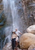
Barnhardt Trail Joe's Falls are probably more similar to a leaking faucet right now, however, enough water to keep a guy alive, soak your hat, head, satisfy the pups or drown someone with a little effort. ;) Dark humor sorry, its an infantry thing.

Plenty of water in canyon adjacent to trail, actually flowing strong in spots, but as an ECON teacher I applied the Law of Diminishing Returns and did a little cost benefit analysis of the situation and scrambling down the steep banks for the sake of a quick swim was not worth it to me today.

No Blanco no Cup today, I think the heat and lack of water may have even got to Blanco today and he is resting up for a quick turnaround to Primitive Blue Range on Wednesday. Likewise, as much as it pains me to say, I am not so inhibited when I go solo and I can really crank out quality miles at a much quicker pace, so it was probably for the best today.

Consumed a lot of water, donated about a half a pint of blood to wilderness Gods and for a third week in a row finished to some nasty thunder and lightning. I am starting to feel like a storm chaser, except the storms are chasing me! :o

Final Note: Bring on this "Midnight Mesa Loop" I hear of...I am ready!...well I think I am anyways ;)
 Flora
 Flora [ checklist ]
[ checklist ]  Poison Ivy
 Geology
 Geology [ checklist ]
[ checklist ]  Maverick Shale
 Culture
 Culture [ checklist ]
[ checklist ]  HAZ - Hike HAZard
_____________________
  2 archives
May 24 2013
avatar

 Photos 100
 Triplogs 15

49 male
 Joined Nov 04 2009
 Gilbert, AZ
Barnhardt - Sandy Saddle LoopPayson, AZ
Payson, AZ
Backpack avatar May 24 2013
lanewinbladeTriplogs 15
Backpack15.00 Miles 4,735 AEG
Backpack15.00 Miles3 Days         
4,735 ft AEG30 LBS Pack
 no routes
1st trip
Linked   none no linked trail guides
Partners none no partners
Car camped at the trailhead on Thursday evening and awoke to absolutely perfect weather. We started up Barnhardt Canyon and didn't see another person the entire day (weird for a holiday weekend). Made the right turn at the Sandy Saddle junction and it quickly became apparent that this trail had not been used in awhile. There were many times where the Mazatzal Wilderness map, a lucky cairn spotting and some dead reckoning came into play to keep us on the trail (a bad omen of things to come). Setup camp at the junction of a dry wash and Barnhardt Creek just West of Castersen Seep. As a side note, I grew up in the midwest and could spot poison ivy from a mile away...but I have never seen poison oak. Needless to say, I know what it looks like now! :D

Day 2 started out just as day 1 ended. We knew we were headed to Sandy Saddle, we could see Sandy Saddle, but finding the trail was the real problem. Cairn spotting became more of a sport than a luxury as we pushed through brush up the spine of the mountain leading us to Sandy Saddle. As we finally reached the saddle, we thought the worst was behind us and we were incorrect. The downhill section is even worse as the creek you follow has suffered severe flooding and the trail is gone. The choice between boulder hopping with a 30lbs pack or pushing through brush was constant. When we finally reached the Arizona trail, it looked like a 4-lane highway. Nice and wide and free of brush!

We setup camp at Chilson Camp and began the search for a water source. The map led us to the Chilson Spring which is inconveniently located 100 yards up a very steep mountain side. A pipe crossing the trail is your first clue, a green 5-gallon bucket on top of said pipe is your second clue and a green patch of vegetation just uphill from said bucket will be your final destination! The water was trickling through and it really tested the limits of my buddy's MSR filter.

On Day 3, we awoke to a deer in camp that awoke everyone with the exception of my guard dog. We walked up to Chilson Spring to filter more water and packed it out back to the car for a few well deserved cold ones (and then to Walgreens for some Caladryl!). Although I've day hiked the Barnhardt Canyon trail before, the Chilson Camp was definitely the highlight of this trip. A perfect little spot to setup base camp and day hike more of the Mazatzal Divide trail.
 Fauna
 Fauna [ checklist ]
[ checklist ]  Dog  Mule Deer
 Culture
 Culture [ checklist ]
[ checklist ]  Campsite  Hammock
 Named place
 Named place [ checklist ]
[ checklist ]  Chilson Spring  Sandy Saddle
_____________________
 
Nov 03 2012
avatar

 Guides 13
 Routes 38
 Photos 1,651
 Triplogs 577

60 male
 Joined Nov 15 2005
 Jackson, CA
Barnhardt - Sandy Saddle LoopPayson, AZ
Payson, AZ
Hiking avatar Nov 03 2012
toddakTriplogs 577
Hiking19.00 Miles 3,500 AEG
Hiking19.00 Miles   10 Hrs      1.90 mph
3,500 ft AEG
 no routesno photosets
1st trip
Up Barnhardt, over Sandy Saddle, south on MD23, down YBar. The "trail" to Sandy Saddle is overgrown and faint-to-nonexistent.
_____________________
 
Mar 21 2011
avatar

 Photos 105
 Triplogs 13

51 male
 Joined Feb 26 2009
 Mesa, AZ
Barnhardt - Sandy Saddle LoopPayson, AZ
Payson, AZ
Backpack avatar Mar 21 2011
Xiled1Triplogs 13
Backpack15.00 Miles 4,735 AEG
Backpack15.00 Miles2 Days         
4,735 ft AEG
 no routesno photosets
1st trip
Linked   none no linked trail guides
Partners none no partners
First time on this trail, beautiful loop with some tough hiking. Water Water everywhere, so there was plenty to drink. Got to check out a number of different falls. Deadman falls was the destination and they were both running pretty well, impressive canyon and shear dropoff.

My wife let the camerabag slide off her pack looking over the edge and down it went. It fell to the first ledge on the closer fall, about 20 feet down. I thought it was a lost cause but fashioned a hook out of a knife and rope. Snagged it on about the 10th try! Lucky - credit card and ID were in there. Saved the trip.

We headed over to Chilson camp for the night. Camping with a supermoon is overrated - its just REALLY bright and makes it hard to sleep. Thats a nice place to throw a tent in that rugged country. Spring had a slow but steady flow. Finished up the loop the next day. Plenty of water and cool temps - great time to check this area out.

water 1 out of 5water 2 out of 5water less than maxwater less than max Chilson Spring Quart per minute Quart per minute
_____________________
 
Dec 02 2010
avatar

 Photos 66
 Triplogs 26

46 male
 Joined Mar 29 2011
 Phoenix, AZ
Barnhardt - Sandy Saddle LoopPayson, AZ
Payson, AZ
Hiking avatar Dec 02 2010
dwsmith11Triplogs 26
Hiking15.00 Miles 4,735 AEG
Hiking15.00 Miles   10 Hrs      1.50 mph
4,735 ft AEG
 no routesno photosets
1st trip
Linked   none no linked trail guides
Partners none no partners
Lost for a good 2 hours due to 2 feet of snow. Beautiful with the snow caps and covering the trail. Exhausting but will do it again this winter. Good times.
_____________________
  1 archive
Apr 24 2010
avatar

 Guides 14
 Routes 115
 Photos 4,830
 Triplogs 3,536

male
 Joined Oct 29 2005
 Scottsdale, AZ
Barnhardt - Sandy Saddle LoopPayson, AZ
Payson, AZ
Hiking avatar Apr 24 2010
topohikerTriplogs 3,536
Hiking20.39 Miles 4,098 AEG
Hiking20.39 Miles   10 Hrs   15 Mns   1.99 mph
4,098 ft AEG
 no routes
1st trip
Linked   linked  
Partners none no partners
Well sometimes the hike that you planned ,doesn't wind up being the one you do. We had set out to do the Rock Creek Loop. The plan was to do it clockwise. I had planned to climbing up the Barnhardt as fast as we could to escape the heat. We made it the top in pretty good time. We went past where the Sandy Saddle intersection was (or what was left of it) and I mentioned to Mike that that trail was hard to follow before the fire and now it's suppose to be gone. I said that I had no interest in that kind of route finding today, so we continued down the Mazatzal divide. I had GPSJoe track loaded, but he hadn't done this section of the divide on his loop. That didn't matter because the Mazatzal dived trail is well defined and easy to follow. When we got close to the other end of the Sandy Saddle / Mazatzal divide intersection, the trail disappeared. I zoomed into GPSJoes tracks to the 20 foot level. We came to the intersection and there was no signs. I studied the maps and the GPS track decided that I needed to turn left to stay on the divide. The trail dumped us right into a dry wash with huge rocks and boulders. We had a heck of a time staying trail even with Joe's track. I used Joes track as a suggested guide , because it looks the trail has changed since Joe last hiked this. The GPS track did keep us in the right direction. After some bushwhacking and major rock hopping down creek beds, we ran into another intersection. Unfortunately it was the Barnhardt trail intersection. I had my GPS zoomed in so tight, I had not seen the bigger picture of taking a wrong turn and going down the Sandy Saddle Trail. We took the Barnhardt back. Along the way we heard some people coming down the waterfall chute. We got back to the Jeep by 5:30 and decided to burn off some of our frustration by doing a couple more miles down the half moon trail.
wildflower observationwildflower observationwildflower observationwildflower observationwildflower observation
Wildflowers Observation Moderate
_____________________
"Everywhere is walking distance...If you have the time"
-Stephen Wright
 
Nov 29 2008
avatar

 Photos 128
 Triplogs 312

39 female
 Joined Feb 01 2007
 Phoenix, AZ
Barnhardt - Sandy Saddle LoopPayson, AZ
Payson, AZ
Hiking avatar Nov 29 2008
lb4449Triplogs 312
Hiking15.00 Miles 4,735 AEG
Hiking15.00 Miles
4,735 ft AEG
 no routesno photosets
1st trip
Linked   none no linked trail guides
Partners none no partners
_____________________
 
Nov 29 2008
avatar

 Guides 9
 Routes 33
 Photos 780
 Triplogs 4,634

44 male
 Joined Nov 25 2008
 Scottsdale, AZ
Barnhardt - Sandy Saddle LoopPayson, AZ
Payson, AZ
Hiking avatar Nov 29 2008
BoonemanTriplogs 4,634
Hiking15.00 Miles 4,735 AEG
Hiking15.00 Miles   8 Hrs      1.88 mph
4,735 ft AEG
 no routesno photosets
1st trip
Linked   none no linked trail guides
Partners none no partners
_____________________
 
Sep 01 2008
avatar

 Guides 3
 Routes 2
 Photos 1,156
 Triplogs 338

53 male
 Joined Aug 22 2003
 Mesa
Barnhardt - Sandy Saddle LoopPayson, AZ
Payson, AZ
Hiking avatar Sep 01 2008
te_waTriplogs 338
Hiking16.20 Miles 4,735 AEG
Hiking16.20 Miles
4,735 ft AEG
 no routes
Linked   none no linked trail guides
Partners partners
nonot
took a few friends into the N. fork of Deadman Canyon to see the incredible falls and canyon. Turned out to be a 16.2 mile loop. Thanks to Fred, John, Betsy, and Nonot for attending. This is my third time here, and the Barnhardt trail is still the only good part of this loop. (not counting the awesome waterfalls in Deadman)
Good times!
_____________________
squirrel!
  1 archive
Sep 01 2008
avatar

 Guides 107
 Routes 249
 Photos 2,067
 Triplogs 514

male
 Joined Nov 18 2005
 Phoenix, AZ
Barnhardt - Sandy Saddle LoopPayson, AZ
Payson, AZ
Hiking avatar Sep 01 2008
nonotTriplogs 514
Hiking15.50 Miles 4,735 AEG
Hiking15.50 Miles   9 Hrs   15 Mns   1.68 mph
4,735 ft AEG
 
1st trip
Fog and clouds throughout the morning acted as a buffer against rising temps for the morning into the early afternoon, though the fog aka humidity, made it somewhat sticky.

Barnhardt Trail was interesting, I checked out the second of the two waterfalls and found the unsigned junction with Sandy Saddle "Trail". The description is right on, I could not locate the trail near Casterson Seep (and could locate no water near Casterson seep). I found it again on the hill to the north for awhile, but attempting to follow the old map led me into some 45 degree vegetation choked slopes. It is far better to descend into the drainage at this point and to follow the creekbed. I located most of the trail on the climb up the steep ridgeline, curse that section!

Sandy Saddle was a bit of a disappointment, but I did see some elk tracks. The descent from Sandy Saddle to the northwest is fairly easily found and followed until you reach the main drainage. I found bits and pieces of the trail, but stayed in the creekbed for a good portion. I eventually found a decent section of trail that allowed me to quadruple my speed. Just before reaching the divide, I caught te-wa's group, who had set off earlier in the day.

I heeded their suggestion and went to see the Deadman Canyon waterfalls, pretty impressive dropping 300-400 feet.

From there we made our way home on the faint Divide trail (though much better than Sandy Saddle), and brought it home on the Barnhardt. The final 3 miles were a bit warm as the sun was out in full strength and we were losing elevation.

I'll give Barnhardt a 4
Sandy Saddle a 0
Divide a 2
Deadman Falls a 5

I guess that averages out somewhere to about 3.

dry Castersen Seep Dry Dry
_____________________
http://hikearizona.com/garmin_maps.php

Hike Arizona it is full of sharp, pointy, ankle-twisting, HAZmaster crushing ROCKS!!
Hike Arizona it is full of sharp, pointy, shin-stabbing, skin-shredding plants!
Hike Arizona it is full of striking, biting, stabbing, venomous wildlife!
 
Jul 24 2008
avatar

 Guides 3
 Routes 2
 Photos 1,156
 Triplogs 338

53 male
 Joined Aug 22 2003
 Mesa
Barnhardt - Sandy Saddle LoopPayson, AZ
Payson, AZ
Hiking avatar Jul 24 2008
te_waTriplogs 338
Hiking17.50 Miles 4,960 AEG
Hiking17.50 Miles   8 Hrs      2.19 mph
4,960 ft AEG
 no routes
Linked   none no linked trail guides
Partners none no partners
woke up Wednesday with the urge to hit a trail. Packed by rucksack and out the door I went to the area around Horse Camp seep. Wanted to get a different perspective on the Deadman Canyon so I went a little farther than the Sandy Saddle (trail?) and came back to it after hanging with some wild winds. Im talking 30mph gusts that shook my whole set-up. The next day I took the wash over the saddle and came back down to meet up w/ the trail on the other side of Castersen wash. Lost the trail but I was feeling energetic so I climbed the backbone of a nearby ridge and took it all the way to Barnhardt trail. This added about a 1.5 mile trip to the total mileage. Lost another gps (it was a cheapie anyhow) down there in the cross country battle w/ manzanita.
Unusual amount of bleeding blisters on this hike- it was hot, about 95. Still water is forming in pools from summer rains. No wildlife save some birds and lizards.

water 1 out of 5water less than maxwater less than maxwater less than max Horse Camp Seep Dripping Dripping
not 100yds west of the small drainage formed by Horse Seep, there is a larger drainage with running water that feeds one of the 2 waterfalls into N. Fork of Deadman Canyon- aided by summer rains Im sure. Water also in the drainage west of Sandy Saddle and again at Castersen Seep.
_____________________
squirrel!
  2 archives
Apr 05 2008
avatar

 Guides 3
 Routes 2
 Photos 1,156
 Triplogs 338

53 male
 Joined Aug 22 2003
 Mesa
Barnhardt - Sandy Saddle LoopPayson, AZ
Payson, AZ
Hiking avatar Apr 05 2008
te_waTriplogs 338
Hiking15.00 Miles 4,735 AEG
Hiking15.00 Miles   4 Hrs   45 Mns   3.16 mph
4,735 ft AEG
 no routes
Linked   none no linked trail guides
Partners none no partners
David and Preston's trip report is spot on... please see hike description and take a map! this was an all day scramble up and down the open hillsides of mazatzal range. all of the trails are easy to follow but a confusing area around Castersen, like Preston said follow the map for advice, there is much deadfall along barnhardt and that's the only issue. start of sandy saddle trail (34' 5.24-111' 27.50) is fairly easy to follow, keep up with the cairns and you shouldnt have a problem. There is a bit of creek bed walking between casterson seep (34' 5.40-111' 28.0) and the ascent to sandy saddle (34' 5.79-111' 28.09). Once you decend sandy saddle to the west, the maz. divide trail (34' 6.42-111' 29.51) is marked with several orange ribbons as of this writing. the divide trail is well kept. I planned on this as an overnight but could not (and i mean it) find 2 suitable trees. place is scorched from head to toes on this loop. my next hike will be divide trail from peeley to the "deer creek falls".
here's some free info: when you are rock hopping down the drainage that comes from west side of sandy saddle, you will come to the intersection with the divide trail. make note of the divide trail and proceed downstream about a 2 minute walk (150 yards?) you will be delighted to find the north fork of deadman canyon, and 2 sick, sick waterfalls. there is info out there on how to rappel these falls, but not me, no sir, no way Jose :lol:
I almost peed myself just looking over the edge of the 250' plunge.
I pretty much kept a sickening 3mph pace the entire way, even over the rocky creekbed and made the loop in a record "under 5 hours" you may find it necessary to spend 7-9 hours on this trail. this is not an easy area to hike in- keep that in mind.
_____________________
squirrel!
  1 archive
Aug 12 2006
avatar

 Guides 170
 Routes 148
 Photos 5,914
 Triplogs 2,097

48 male
 Joined Apr 12 2004
 Tucson, AZ
Barnhardt - Sandy Saddle LoopPayson, AZ
Payson, AZ
Hiking avatar Aug 12 2006
PrestonSandsTriplogs 2,097
Hiking16.00 Miles 4,735 AEG
Hiking16.00 Miles   15 Hrs      1.07 mph
4,735 ft AEG
 no routes
1st trip
Linked   none no linked trail guides
Partners partners
david_allen_3
This was an extremely long dayhike and side trip with david_allen_3. After a swollen Rye Creek thwarted our efforts to hike the Rock Creek Trail (I camped next to Rye Creek the night before, and fell asleep listening to boulders rolling down the flash-flooding creek bed), we chose this hike. We started at 6 am, and got back at 9 pm. It was nice to see all the creeks flowing, and there was water and green grass everywhere! We started out hiking in the clouds with the humidity probably close to 100%. We made good time until we hit the Sandy Saddle Trail. It was very slow travel along the Sandy Saddle Trail (very little left of it). Unfortunately for me, my digital camera died near the beginning of the Sandy Saddle Trail. :cry: After a long, sweat-dripping ascent to Sandy Saddle, and extensive boulder hopping on the other side, we arrived at the Mazatzal Divide. The Mazatzal Divide Trail sure was a welcome treat after Sandy Saddle. We had some lunch, then headed down the Mazatzal Divide to it's junction with the Barnhardt Trail. We finished out the last 2 miles of trail by flashlight; absolutely dead exhausted. I would have gladly slept in the middle of the trail. :wink: An awesome adventure! Didn't see anyone else all day except for 2 guys who were going to do the Mazatzal Peak Loop.
 Geology
 Geology [ checklist ]
[ checklist ]  Mazatzal Quartzite
_____________________
"…you never know when a hike might break out" -Jim Gaffigan
 
May 13 2000
avatar

 Routes 44
 Triplogs 48

70 male
 Joined Mar 12 2002
 Mesa, AZ
Barnhardt - Sandy Saddle LoopPayson, AZ
Payson, AZ
Hiking avatar May 13 2000
jhelfersTriplogs 48
Hiking16.00 Miles 4,735 AEG
Hiking16.00 Miles   9 Hrs      2.00 mph
4,735 ft AEG   1 Hour    Break
 no routesno photosets
1st trip
Barnhart Trailhead—Horse Camp Seep and back via Castersen Seep.
14 mi.

As usual, an easier hike up to the Castersen Seep Trail junction. Manzanitas in bloom, other flowers, many birds, lizards. Met maybe 12 people.
Cutoff trail to Castersen Seep is moderate down. Sign is down at Castersen Seep; the seep itself is slightly east of the trail, beyond the main camping area. Though there was no running water, the seep itself had two large pools remaining. On the way back, we found the pools and filtered water.
From Castersen to Sandy Saddle is steep (1 hr. up, c. ½ mi.) It’s hard to go up, but doable, better early in day.
At Sandy Saddle, we decided to check Horse Camp Seep. (We got there circa 2:30 p.m.) Horse Camp was not running, though we found one waterpocket remaining after a short reconnaissance.
The Barnhart waterfall was still barely trickling, with waterpockets. We made it down by 7 p.m., after starting @ 9:30 a.m.
_____________________
 
May 13 2000
avatar

 Routes 36
 Photos 2,658
 Triplogs 1,347

67 male
 Joined Jul 28 2004
 Scottsdale, AZ
Barnhardt - Sandy Saddle LoopPayson, AZ
Payson, AZ
Hiking avatar May 13 2000
mazatzalTriplogs 1,347
Hiking16.00 Miles 4,735 AEG
Hiking16.00 Miles   9 Hrs      2.00 mph
4,735 ft AEG   1 Hour    Break
 no routesno photosets
1st trip
We went up Barnhardt and took Sandy Saddle to Mazatzal Divide trail (this was before the fire and SS trail was okay back then). We took a detour to Horse Camp Seep and then completed the loop on MDT and Barnhardt.

We drove over to Rock Creek and car camped so we could do Rock Creek the next day. Dinner: steak, asparagus and beer. :)
_____________________
 
average hiking speed 1.99 mph

WARNING! Hiking and outdoor related sports can be dangerous. Be responsible and prepare for the trip. Study the area you are entering and plan accordingly. Dress for the current and unexpected weather changes. Take plenty of water. Never go alone. Make an itinerary with your plan(s), route(s), destination(s) and expected return time. Give your itinerary to trusted family and/or friends.

helpcommentissue

end of page marker