username
X
password
register
for free!
help
ArticlesGuidesRoutes
 
Photosets
 
 Comments
triplogs   photosets   labels comments more
Cottonwood Mountain Trail #66 - Santa Teresas - 10 members in 15 triplogs have rated this an average 3.6 ( 1 to 5 best )
15 triplogs
login for filter options
May 07 2024
avatar

 Routes 9
 Photos 490
 Triplogs 20

female
 Joined May 20 2016
 AZ
Cottonwood Mountain Trail #66 - Santa TeresasTucson, AZ
Tucson, AZ
Hiking avatar May 07 2024
WildForAZTriplogs 20
Hiking11.22 Miles 2,692 AEG
Hiking11.22 Miles   8 Hrs      1.40 mph
2,692 ft AEG
 
1st trip
Linked   none no linked trail guides
Partners none no partners
As others have said in their trip reports, there are three gates on FR677 (and most park at the third gate). I have 4WD with high clearance, but I wasn't liking the deep diagonal and horizontal ruts, so I parked at gate #1 and walked the rest of the way. In hindsight after seeing the road condition to gate #3, I probably could have driven there.

At the end of the road at gate #3, I had a hard time finding the trail. I ended up walking along the creek, which is mostly where the trail goes anyway. I walked it all the way to the section where the trail leaves the creek and heads up the mountain. Well, except for one huge waterfall (maybe 30 feet) that had to be hiked around on the west side. A nice path right there goes up and around it.

When I left the creek, I again had a hard time finding the trail. I lost track of it a few times. Some blood was donated in this area thanks to lots of catclaw :lol: . The trail eventually became easier to see, and was much better starting from below the switchbacks until the saddle at the top of the ridge. A lot of vegetation has grown in the middle of the trail. Several times the growth made the trail appear to just end. And from the creek to the switchbacks, a long distance of the trail is covered in small ankle-rolling rocks.

The trail from the saddle to the summit of Cottonwood Mountain is marked on topo maps as Gardner Canyon Trail #67, but all I could find were occasional cairns. It was a bushwhack to the summit and benchmark, but it was not that bad for a bushwhack. There was even a nice animal path through a big patch of burned manzanita bushes.

The views were not bad for the majority of the hike before reaching the saddle (except for the burned trees). But once on top and you get to look down the other side to the north and northwest, that's when things really become spectacular! I went over to the edge many times to take photos of the beautiful rock formations and views.

Cottonwood Canyon was flowing, and the frogs were really singing on my way out. Saw one cow by the creek, and later saw two jackrabbits along Klondyke Road (plus lots more cows). I had the whole area to myself for the entire day - no humans seen at all.
 Fauna
 Fauna [ checklist ]
[ checklist ]  Canyon Tree Frog
 Culture
 Culture [ checklist ]
[ checklist ]  Benchmark
wildflower observationwildflower observationwildflower observationwildflower observationwildflower observation
Wildflowers Observation Light
Thistle, Verbena, Fleabane, Indian Paintbrush, Sego Lily and a few others.
_____________________
  3 archives
May 06 2024
avatar

 Guides 104
 Routes 256
 Photos 16,118
 Triplogs 528

53 male
 Joined Dec 30 2005
 Tucson, AZ
Cottonwood Mountain Trail #66 - Santa TeresasTucson, AZ
Tucson, AZ
Hiking avatar May 06 2024
Mike_WTriplogs 528
Hiking9.67 Miles 2,095 AEG
Hiking9.67 Miles   7 Hrs      1.38 mph
2,095 ft AEG
 
1st trip
Linked   linked  
Partners none no partners
This triplog involves a good portion of the Cottonwood trail and continues to the Cottonwood mountain summit.

Brian and I camped just North of Oak Butte Sunday night after hiking Pinnacle Ridge. The night time low was supposed to be around 50-52 which was reasonable. The worst part of it was the wind. It was extremely windy in this area on Sat & Sun nights and I had a lot of trouble getting to sleep BOTH NIGHTS in my old Coleman tent which was flapping in the wind for many hours. In the early hours of the morning, the wind died down a lot and I was awoken to bird sounds. I don't know how many hours of sleep I had but I suspect it was only a few. Anyway, I had enough energy to do another long hike.

We drove from our camp area to the Cottonwood mountain trailhead and parked at the turn-around near the end of FSR 677. From there we walked down the old 4x4 road North to the gate. Just past the gate there was an old trailhead sign for the Cottonwood mountain trail #66. We were on this trail and the surrounding cattle trails the previous day when we hiked to Pinnacle Ridge, so some of this hike had some overlap. We followed a fairly well-defined trail that was West of Cottonwood canyon. We ended up crossing the canyon a few times and then the trail eventually went West, out of the canyon, and climbed up. Luckily there were some cairns so it wasn't too difficult to find the trail. There was water in the stream and at a certain point, we heard a waterfall in the canyon. The waterfall was mostly blocked by trees and brush, but we were able to see it through the brush.

We continued going up and after hiking a total of 2.1, we stopped for a water break and snack near a big tree. After the break we continued following the trail up and after reaching a distance of 2.25 miles from the trailhead, we found a beehive in a tree and had to get away quickly. Right in this area we saw some nice penstemon and verbena flowers. We continued up the trail and knew we needed to look for some switchbacks heading up. We found those switchbacks after about 2.7 miles. There was no sign but we did see a cairn that appeared to be off the main trail. The trail we were on seemed to continue straight. We walked about 10 feet up to the cairn and this is where the trail turned to the left and continued heading up. We followed a few switchbacks and the trail wasn't too steep here but kept climbing for a long time.

After hiking a total of 3.75 miles we reached a nice saddle. There was a huge dead white tree, most likely a sycamore, near this saddle which made for a nice photo. We even climbed 6-8 up into the tree for a nice photo. It was already 12:30 pm by the time we got here, so we decided to have lunch here. After having lunch we took some photos over the cliffs to the Northwest and the surrounding area. We saw some deer tracks up here but didn't see any animals the entire day except for a few birds, lizards, etc. We also noticed that based on our current elevation, we only seemed to have another 100 feet of elevation. From the saddle, we didn't see a clear trail but it looked like the best way would have been to go up the middle of the ridgeline. We went up and as we got higher up, it started looking like a real trail and we saw more cairns. It's possible that a previous fire destroyed a section of trail between the saddle and the top of the ridge. When we got to the top of the ridge it was obvious where to go. We followed a pretty clear cairned trail, but there were a few confusing areas. When we looked carefully, we eventually found cairns and this trail eventually led us to the summit. This was probably the least well-maintained section of trail on the entire hike, and therefore it took us longer.

At the summit, we found a large cairn and very close to it, there was a rock pile with a registry inside. Looking to the West, we were able to see the Pinnacles on Pinnacle Ridge, the area we were at the previous day. After signing the registry, we hiked down going basically the same way. It was easier going down because we didn't have to do as much route finding. We basically knew where to go in general, but there were a few tricky areas. We finished the hike around 6 pm and had about 1.5 hours before darkness.

Flowers/plants seen: pink penstemon, verbena, clasping venus' looking-glass, antelope horns plant, Rose's claret-cup cactus, lupine, fleabane, wolly ragwort, giant red indian paintbrush, white tackstem, New Mexico plumeseed, desert dandelion, white mariposa lily

Stats:
-------
Distance (round trip) = 9.67 miles
AEG = 2,095 feet
Strava moving time = 5 hrs 33 mins
Strava elapsed time = 8 hrs 29 mins
wildflower observationwildflower observationwildflower observationwildflower observationwildflower observation
Wildflowers Observation Isolated
pink penstemon, verbena, clasping venus' looking-glass, antelope horns plant, Rose's claret-cup cactus, lupine, fleabane, wolly ragwort, giant red indian paintbrush, white tackstem, New Mexico plumeseed, desert dandelion, white mariposa lily
_____________________
Michael Williams
IT Professional
Rocky Point Vacation Rentals
Ocean Front Condo in Rocky Point, Sonora, Mexico
www.beachfrontmexico.us
Image
 
May 05 2024
avatar

 Guides 104
 Routes 256
 Photos 16,118
 Triplogs 528

53 male
 Joined Dec 30 2005
 Tucson, AZ
Pinnacle Ridge HP Santa Teresa MtnsTucson, AZ
Tucson, AZ
Hiking avatar May 05 2024
Mike_WTriplogs 528
Hiking8.10 Miles 2,910 AEG
Hiking8.10 Miles   9 Hrs   32 Mns   1.01 mph
2,910 ft AEG   1 Hour   30 Mns Break
 
1st trip
Partners none no partners
Note: We did this hike in conjunction with Blue Ridge - Peak 6420. All stats for both hikes are included here.

I read a lot of trip reports for this hike and noticed that many people used climbing gear, and some did not, but wasn't sure if we were going to feel safe enough getting up the final climb section to the summit.

Starting from where we parked, we walked a few hundred feet North on FSR 677 to an unlocked gate, which we crossed through. Just past the gate we saw an old sign marking the Cottonwood Mt trail # 66 with arrows pointing forward. We didn't see a distinct trail but rather many cattle trails all around here. We were surprised to see a stream here with flowing water. There was evidence cattle were here and this was probably their main source of water. We continued North following Cottonwood wash taking various cattle trails that seemed to be mostly on the East side of the wash.

After about 1/3 of a mile, we crossed the wash and found some better trails on the West side of the wash. From here, we followed cattle trails until we hiked a total of about 0.8 miles. We could see a branch of Cottonwood wash that turned and went Northwest. We found other cattle trails that went up the ridge from here and toward Peak 6420 which is part of Blue Ridge. We followed cattle trails to a saddle South of Peak 6420, then did an open country hike to the summit of Peak 6420 which was not far out of the way from our final destination of Pinnacle Ridge. We found a registry under a rock pile at the top of this peak and signed it. There were some burned trees here and we had some good views of the Pinnacle Ridge high point from here. We saw some other interesting rock formations further down the ridgeline. We also saw a large pond to the Southwest which we believe was called Devil Tank.

We left Peak 6420 heading North toward a flatter area with rock formations ahead. We hiked through various rock formations and headed towards the saddle East of Pinnacle ridge, which didn't appear to be very high up from where we were. We continued climbing up toward the saddle. There were some messy areas along the way, but with some zig-zagging we made it to the saddle. From here, we knew that the best route going toward Pinnacle peak was to stay South of the rock formations and South of the manzanita area.

Shortly after getting to this saddle, the hike got messier, steeper, and scrambling was involved. There were many areas where we needed to use our hands and zig zag to get better footing. It's important to note that a wildfire had burned through this area in years past which must have produced a lot of loose dirt which was a sliding hazard. We kept going higher and heading toward the pinnacles. For the final 0.25 miles, we needed to go around the left side of one more huge rock formation. After doing that we had a clear look at the chute leading up to the high point. We hiked up the chute and had to do some scrambling to get to a gap where we could see on either side of the mountain. From the gap there were two high points, each about 20 feet higher than where we were. One to our left and one to our right. We realized based on other people's photos and trip reports that the peak was to the right. Basically, the route curled clockwise at the very end.

If you see anything that looks incredibly difficult to climb, it's likely that this is not the summit or you are going the wrong way. On the final section, I put gloves on to make the climbing easier. I needed to get myself through a slot where there were some gaps going down. There was never a point here where I felt in any danger. Once beyond this section, I saw two rock slabs that I needed to get through the middle of. It was very narrow near the bottom, therefore I needed to put my back against the left side and feet against the right side and work my way forward and UP to the next section. The next section had even a smaller gap between the rocks which got larger after I worked my way up higher. I needed to wedge myself between the rocks and slide horizontally and UP roughly 4 to 5 feet. Once at that position, I had a flat area to rest and from here I was probably 10 vertical feet from the summit. I found good foot holds and hand holds going up with only some exposure. There was a slot in the middle that was somewhat protective and I felt like I didn't need any ropes or climbing gear here. Being tall helps in this area. I actually had a harder time squeezing between the rocks on the previous move before doing the final climb. The final climb was straight-forward to me and not scary, but of course I've done many climb sections on various hikes over the last 12-15 years.

At the summit, there was enough space to sit down. It was very windy so we didn't stand for very long. We signed the registry and got some photos & videos from the top and then decided to head down.

Getting down the climb section wasn't too bad for me since I'm over 6 feet tall. I sat down and spider crawled my way down the same way I came up. There was a large rock where I was able to stretch to and place my right foot and assist. Then, I used the foot holds and hand holds to get down to a flat platform area. Next, I needed to proceed between the rock slabs. This felt a bit scary because I was suspended between the rocks about 6 to 8 feet below the bottom and there was a potential of falling here and getting scratch up by the rocks on either side. I needed to inch myself across and down to the wider section below. This felt rather awkward because I needed to move from a narrow gap to a wider gap while having my body wedged in the middle, without any good hand holds. It took me about 5 minutes or more just to get past this section. If I had to do this again, I would have put my back against the other side of the rock (left side when coming down) that was one continuous slab, and therefore, it would have been easier to transition from a narrow wedge to slightly wider wedge by using my legs. After getting by that section I felt relieved because the hard part was over.

Next, we basically continued down the way we came up. We stayed a little higher on the ridgeline in some areas which was slightly better, but there were some slippery dirt sections that we needed to go down. We found that staying more on the rocks were helpful. It took up roughly 1 hr 45 mins to get from the summit to the high saddle to the East. This was the hardest part of the hike, not including the climbing/obstacles at the top of the summit.

After we got down to the saddle South of Peak 6420, we found some cattle trails heading Southeast around peak 6161. We decided to take this shortcut down this other ridgeline because we thought it would save us some time and it apparently did. There were pretty good cattle trails the entire way down to, and along the West side of, Cottonwood wash. We arrived back at the vehicle before it got dark and drove back to our campsite North of Oak Butte. All in all, it was a difficult hike but the final climb section wasn't nearly as scary as we thought it would be.

Timeline:
--------------
09:55a (0 mi) - started hike near end of FSR 677
10:26a (0.81 mi) - turned to go up ridge going NW
11:06a (1.66 mi) - reached saddle South of Peak 6420
11:23a (1.96 mi) - reached summit of Peak 6420
12:00p (2.04 mi) - left summit of Peak 6420, needed to hike around various boulder sections for the next 30 minutes or so
12:29p (2.71 mi) - starting going up to the low saddle
1:01p (3.20 mi) - reached saddle East of Pinnacle Ridge. After this point, the hike gets harder. There's some side hilling and scrambling required. There are some very steep dirt area where you will need to use your hands.
1:48p (3.71 mi) - reached huge rock formation that we knew we needed to go South of
2:12p (3.88 mi) - got around huge rock formation, looking up at
3:04p (4.08 mi) - reached Pinnacle summit!
3:28p (4.12 mi) - left summit
5:14p (5.02 mi) - reached a point just South of the saddle East of Pinnacle Ridge summit
5:45p (5.55 mi) - reached relatively flat area
6:13p (6.20 mi) - reached saddle North of Peak 6420
6:29p (6.61 mi) - back at the saddle South of Peak 6420, then followed cattle trails around Peak 6161 and decided to go down a different ridgeline to get back to Cottonwood wash. We basically followed cattle trails all the way down and felt like this was a faster/better way to get back to the trailhead.
7:25p (8.08 mi) - back at the trailhead sign for Cottonwood trail
7:28p (8.14 mi) - arrived back at vehicle

Stats:
---------
Distance (round trip) = 8.14 miles
AEG = 2910 feet
Strava moving time = 4 hrs 44 mins
Strava elapsed time = 9 hrs 32 mins
wildflower observationwildflower observationwildflower observationwildflower observationwildflower observation
Wildflowers Observation Isolated
thistle, verbena, white mariposa lily, hedgehog cactus flower, silverpuff, Classen's cactus with flower, Bluewitch nightshade, Western wallflower, pink penstemon, banana yucca

water 1 out of 5water 2 out of 5water 3 out of 5water 4 out of 5 Devil Tank 76-100% full 76-100% full
appeared to be a constant water source for the cattle nearby

water 1 out of 5water 2 out of 5water 3 out of 5water less than max Limestone Canyon Medium flow Medium flow
Light to medium flow. We heard a waterfall from at least 100 feet away and were able to see it through the trees. Probably a few gallons per second flow.

water 1 out of 5water less than maxwater less than maxwater less than max Sand Tank 1-25% full 1-25% full
Water a few inches deep and could be filtered for drinking. There was a slow flow.
_____________________
Michael Williams
IT Professional
Rocky Point Vacation Rentals
Ocean Front Condo in Rocky Point, Sonora, Mexico
www.beachfrontmexico.us
Image
 
Feb 21 2022
avatar

 Photos 916
 Triplogs 20

37 male
 Joined Jan 17 2011
 Phoenix, AZ
Cottonwood Mountain Trail #66 - Santa TeresasTucson, AZ
Tucson, AZ
Hiking avatar Feb 21 2022
johnny88Triplogs 20
Hiking10.84 Miles 2,469 AEG
Hiking10.84 Miles
2,469 ft AEG
 no routes
1st trip
Linked   none no linked trail guides
Partners none no partners
After backpacking the Holdout-Blackrock loop, I car camped nearby and did a day-hike up the Cottonwood Mountain trail. My vehicle can't make it all the way to the trailhead, so I had a couple miles of forest road walking to start. The first half mile or so of the actual trail is mostly obliterated by the 2021 Pinnacle Fire and following Monsoon floods. After the first half mile, I found a trail-like path and mostly managed to follow it the rest of the way.

I didn't summit Cottonwood Mountain - I went to the saddle and hiked around that area instead. The trail from the lower canyon area up through the main climb is largely burned and overgrown with grass and the occasional catclaw. Once I reached the saddle, I was surprised that the area beyond it looked fairly untouched. This area offers some fantastic views of the area where Black Rock and Holdout canyons meet. After a good snack break, I hiked back down the way I came. Saw no one, even on the forest road walking.
_____________________
 
Oct 11 2020
avatar

 Guides 110
 Routes 2,246
 Photos 8,982
 Triplogs 2,600

45 female
 Joined Dec 24 2007
 Ahwatukee, AZ
Cottonwood Mountain Trail #66 - Santa TeresasTucson, AZ
Tucson, AZ
Hiking avatar Oct 11 2020
LindaAnnTriplogs 2,600
Hiking8.13 Miles 2,300 AEG
Hiking8.13 Miles   5 Hrs   47 Mns   1.68 mph
2,300 ft AEG      57 Mns Break
 
1st trip
Linked   linked  
Partners partners
AugustWest
Route Scout Route Recorded  on Route Scout | Pop | Map | Popup | MapDEX
The road is high clearance 4wd to the third gate, after that, don’t bother. Expect to get some pinstripes. Cool temps to start. The road/trail heads over to the creekbed and generally either stays in the creek, or up on the left bank. Eventually, the trail turns up to the left away from the creek and heads uphill. Faint in places, but generally easy to follow. I was glad I wore pants and not shorts because there was some thorny vegetation along and in the trail.

As the trail gets higher, it switchbacks up the slope before topping out. At that point, we turned left and headed off trail along the ridge. Generally easy off trail, with some manzanita to push through. There were more cairns than I was expecting to see, but as long as you follow the ridge, you’ll stay on track. The cairns kept us mostly on the left side of the ridge. Nice views in all directions from the top, with plenty of rocks to sit on for a break. Despite being surrounded by desert, it was interesting to see a nice stand of pines on the north side of the summit.

Retraced our steps back down, taking a slightly easier route through the section of manzanita. Definitely warm as we headed downhill, but a nice breeze at times helped. Nice trail in a quiet area with plenty of solitude, good to do something new.
 Culture
 Culture [ checklist ]
[ checklist ]  Benchmark
_____________________
Stop crying and just go do the hike.
 
Oct 11 2020
avatar

 Routes 174
 Photos 471
 Triplogs 184

51 male
 Joined Mar 16 2019
 Phoenix
Cottonwood BM 7481Tucson, AZ
Tucson, AZ
Hiking avatar Oct 11 2020
AugustWestTriplogs 184
Hiking8.50 Miles 2,303 AEG
Hiking8.50 Miles   5 Hrs   47 Mns   1.78 mph
2,303 ft AEG   1 Hour    Break
 
1st trip
Partners partners
LindaAnn
Route Scout Route Recorded  on Route Scout | Pop | Map | Popup | MapDEX
Fun day out in the Santa Teresa Mountains. These mountains are beautiful, rugged and bone dry right now.

The road to the trailhead is definitely 4WD and high clearance, but is very doable up to the 3rd gate with any offroad experience. Going past the 3rd gate is inadvisable and really unnecessary.

We made our way up the creek bed which has some interesting geology and some decent sized sycamores. Once the trail pulls away from the dry creek, it heads straight up the mountain at a fairly moderate grade. There are baseball sized rocks making up the tread that are about average for Arizona, but the trail itself is very easy to follow and we didn't lose the trail proper one time.

There are decent switchbacks of primarily oaks with some pine that make up most of the AEG of the hike. Once up to the saddle finding our way to the highpoint of Cottonwood Mountain required some off trail travel that really only had us pushing through manzanita for a short stretch. The final push up to the ridgeline was not too hard to figure out with cairns that show a light path requiring only common sense in its orientation.

Once up to the highpoint we took some time to eat a little and figure out where we were relative to the surrounding mountains. There is some really interesting geology and 360 degree views of the rest of the Santa Teresa's, Pinaleño's, Galiuro's, Pinal's, Mt. Lemon and points further. This is a great area that deserves further exploration and attention. We didn't see anyone on the road to the trailhead or on the trail.
_____________________
Wildflower seed in the sand and wind
May the four winds blow you home again
 
Jan 18 2020
avatar

 Routes 2
 Photos 64
 Triplogs 10

35 male
 Joined Sep 09 2015
 Tucson, AZ
Cottonwood Mountain Trail #66 - Santa TeresasTucson, AZ
Tucson, AZ
Backpack avatar Jan 18 2020
derpsquadTriplogs 10
Backpack15.00 Miles 2,297 AEG
Backpack15.00 Miles
2,297 ft AEG
 no routesno photosets
1st trip
Linked   linked  
Partners none no partners
There's a few good campsites on 677 if you like to sleep near the TH the night before. You'll need a 4x4 for the last mile or so.

Overnight into the Santa Teresas. Good trail conditions up Cottonwood Mountain. Some route finding over to the peak but nothing too crazy. Beautiful 360 views up top! 2-8" of patchy snow above 6k' on the Eastern slopes made route finding a little tough making our way towards Fourmile Spring. Awesome pine area with a couple gushing waterfalls.

Just before Fourmile Spring to just before the decent to Kane Spring the trail is completely overgrown with Manzanita. It's easy to follow but be prepared to be pushing through bushes for a couple miles. Decent to Kane Spring is pretty easy going, just watch out for some tricky switchbacks.

Kane Spring would be a great place to camp if it were not completely destroyed by cattle activity. There was 20+ cows when we got there. We were forced to sleep in a uncomfortable spot but it wasn't covered in feces so a win there I guess. Back out the way we came in the next day.

Use the Grand Enchantment #8 GPS route - it's dead on. The Official Route in the Guide is not accurate.
Flowing water in every drainage this time of year. Kane Spring is dry.
_____________________
 
Dec 09 2018
avatar

 Guides 94
 Routes 840
 Photos 22,055
 Triplogs 1,993

52 male
 Joined Sep 18 2002
 Tempe, AZ
Cottonwood Mountain Trail #66 - Santa TeresasTucson, AZ
Tucson, AZ
Hiking avatar Dec 09 2018
chumleyTriplogs 1,993
Hiking9.50 Miles 2,297 AEG
Hiking9.50 Miles
2,297 ft AEG
 
1st trip
Linked   linked  
Partners none no partners
I have eyed this trail on maps and always looked at the ridgeline when driving by on the Klondyke road. Finally I decided to take the opportunity of being in the area to check this one out.

The road was fine. It's 4wd for sure, but just because of steep and loose gravel. Once you get to the FS boundary it deteriorates quickly but most park here anyway. I drove a short distance before giving up on it and was glad I did. There's no reason to go all the way to the official end. (Sand Tank has been blown out by a flood. It's gone.)

There was a light flow of water in the creek which was nice. I wore my pfancy dirty girl gaiters which were helpful because the trail was overgrown with grass. It has been maintained since the HAZ description was written. It's easy to follow and in general an absolute pleasure reminiscent of Coyote Peak near Babo, only it's actually been cleared in the last 5 years! There were a couple of spots with some light catclaw, but following the route was not at all challenging. Despite carrying them, I never considered zipping my pant legs on.

The trail construction is exquisite and a really enjoyable to make this steady but steep climb up into the heart of the Teresas. At the crest I headed north to 7396 before going back to find the Cottonwood BM. The saddle area is remarkably flat with nice grassy meadows, a few ponderosa, and plenty of great views and places to camp. I even saw 5 deer up here! There was also some remnant snow on the north slopes.

The route over to Cottonwood was faint, but in general found where you would expect it to be. I would like to camp up here sometime and spend a day exploring over to Pinnacle Ridge and search for any remnant of the Gardner Canyon Trail.

The register hadn't seen a name in over a year, but there were a bunch of visitors in 2012. It seems to be a regular peak for the SAHC. Otherwise entries went back to 1992. Apparently some people think this is a range or wilderness highpoint (register and haz description mention it) but I'm not really sure how that math works out (the top of Pinnacle Ridge just 2 miles west is almost 100 feet higher). In any case, it's an absolutely great peak, far exceeding my expectations and better than most other sky island peaks I've been on without question.

Season note: This trail is 100% south facing and exposed. I wouldn't want to hike it on any day where it's over 80 in Phx. Winter is nice if there's not too much snow up top, late fall or early spring work too.
 Flora
 Flora [ checklist ]
[ checklist ]  Cranesbill
 Culture
 Culture [ checklist ]
[ checklist ]  Benchmark
 Named place
 Named place [ checklist ]
[ checklist ]  Pinnacle Ridge
_____________________
I'm not sure what my spirit animal is, but I'm confident it has rabies.
  2 archives
Nov 10 2018
avatar

 Guides 1
 Routes 1
 Triplogs 24

45 male
 Joined Feb 27 2012
 Cochise County
Cottonwood Mountain Trail #66 - Santa TeresasTucson, AZ
Tucson, AZ
Backpack avatar Nov 10 2018
AndrewAZTriplogs 24
Backpack9.50 Miles 2,297 AEG
Backpack9.50 Miles2 Days         
2,297 ft AEG
 no routesno photosets
1st trip
Linked   none no linked trail guides
Partners none no partners
My hiking partner and I attempted Segment 8 of the GET in March without success (we did finish Segment 7, Aravaipa Creek, which was a delight). Dropping into Laurel Canyon on Trail 68 from the 4-wheel drive road was fine, climbing Trail 68 to Reef Tank was challenging but manageable, and the descent into Holdout Creek from Reef Tank was not bad overall, but the part from Holdout Creek to Black Rock Creek was a nightmare. It seemed like a never-ending maze of thornbrush with the occasional fifty foot stretch of discernible path with some bits of blue flagging tape. After making it to the corral at the junction (one of the best backcountry campsites I’ve ever had), we decided we didn’t want to find out how rough the upcoming cross-country section was or the trail over Cottonwood Mountain and got ourselves out of the wilderness by [exact method redacted for national security reasons].

Leaving trails unexplored bothers me, so I decided to go back into Segment 8 using the route we would have exited on. A long weekend in November with a cold front moving in seemed like the perfect time to possibly camp at 7000 feet in the middle of nowhere.

I parked along FR 677 when it started to get rough enough that I wouldn’t want to drive out with sore feet, which left me about 45 minutes of road walking to get to the gate at the National Forest boundary. A red Jeep passed me and then I met them again on their way out. I encountered one hunter walking along the road who said he had seen one rabbit and two quail.

There was decent water flow from the National Forest boundary until the point where the trail left the wash to climb up over Cottonwood Mountain. I spooked a deer within 10 minutes after entering the National Forest—obviously it knew where to hide from that hunter.

The trail was overgrown with grass, but not too much thorn brush. I saw a wild squash plant of some kind with two round squash about the size of a baseball. The trail was occasionally tough to follow through the tall grass, but it never took more than a pause and careful look around to find it again.

The trail work in 2015 became apparent once the trail left the wash area to climb. Although still overgrown with tall grass, a very obvious corridor had been cleared through the manzanita, junipers, and thorn brush. The switchbacks were also well-built and still in good shape. It was a hot climb in the sun with no breeze, but it never felt uncomfortably steep.

Breaking over the top was something out of a fantasy book. It didn’t feel like I had passed 7000 feet, so I assumed the wall of brush was a false summit—it wasn’t. The trail broke through the wall...and that was it. I was on top and could already see a bit into Holdout Canyon. I was also instantly chilled by the strong wind after getting all sweaty on the climb.

It was short walk to the overlook into Holdout Canyon. From above, it was hard to believe I had been in that maze in March. It looked utterly impassable (which was close to true). It’s a shame Gardner Canyon Trail #67 no longer exists. The views coming up from Holdout must have been stunning.

I was pleasantly surprised by all the pine trees. From the desert along FR 677, this has to be one of the shortest sky island desert-to-pine transitions, especially for not feeling cruelly steep. It was only a few minutes before I met two deer. One was barely concerned with my presence and did no more than keep a large bush between the two of us while she continued eating.

There was more water flowing in Fourmile Canyon, and it also had the densest stretch of pine trees. Several spots looked like they’d make a good camping site, but it was still early afternoon.

From Fourmile Canyon to a gate along the ridge (about a mile stretch) is the part that needs the most trail work. The manzanitas are doing their best to grow over the trail, and a few more years of growth will create an impassable wall. There are already a few downed trees that require fighting through manzanita to get around, and as mean as I am, a thicket of manzanitas all over 6 feet tall is way meaner.

The drop from the ridge down to Kane Spring was generally easy to follow. There were a few switchbacks that zigged unexpectedly, but nothing too bad. There were some good views of Mt Turnbull and some partial views of Black Rock.

Everything at Kane Spring was dry. The three metal tanks near the corrals were empty and had holes in them, which isn’t promising for them ever having water again. The metal tank up the wash from them was empty. The big camo tank farther down the trail was empty. I was thankful I had carried too much water.

I set up my tent and then wandered down the trail a little to see if I could get a better view of Black Rock. I could see from the GET elevation profile that there was a big drop and I didn’t feel like losing and then gaining a big chunk of elevation to end my day, so I turned around before long when the view didn’t materialize.

While I ate dinner, I heard a yowling noise in the vicinity of the corrals (I was a little farther down the trail towards the camo tank). I pondered what could make such a noise, and then it happened again, but it was longer and then became a high-pitched scream towards the end. I mentally ran through my list of what might make such a noise and wasn’t pleased with the candidates. I didn’t hear anything further and never saw anything, so the mountain lion must’ve decided I didn’t look like dinner.

I have no doubt it got quite cold overnight on top of the mountain, but it stayed much warmer than I expected in the little canyon where Kane Spring is. I don’t think it dropped much below 50 there. The large number of east-west jets was much harder on my sleep than the temperature. The wilderness must be in a major flight path.

The hike out the next morning was uneventful. I didn’t see any people or any noteworthy wildlife. Aside from the Jeep and the walking hunter, I had it all to myself. Not bad for a long weekend.

water 1 out of 5water 2 out of 5water less than maxwater less than max Fourmile Spring Quart per minute Quart per minute

dry Kane Spring Dry Dry
_____________________
 
Dec 27 2014
avatar

 Guides 37
 Routes 556
 Photos 10,872
 Triplogs 1,052

43 male
 Joined Jan 21 2013
 AZ
GET 7 through 9, AZ 
GET 7 through 9, AZ
 
Backpack avatar Dec 27 2014
FOTGTriplogs 1,052
Backpack61.94 Miles 11,320 AEG
Backpack61.94 Miles4 Days         
11,320 ft AEG
 
1st trip
The Grand Enchantment Trail was never on my radar until azdesertfather suggested knocking out segments 7,8,9 over a three day trek. I thought it sounded cool and said sure. After all I had never did Aravaipa and had heard great things about the Santa Teresa's from the few that have hiked them. I had to leave the pups back on this one because of Aravaipa which was a bit of a bummer. However, I was excited to get to a new area and knock out some more mileage over my holiday break and I knew the kiddos would be in good hands at uncle Chumleys.

Day 1: Section 7, Aravaipa Wilderness

This day would be characterized by closed highways, a late start, wet boots and cold water. We knew we were going to get a late start on the first day, as we had to set up our shuttle. This meant a 330 departure time from Phoenix for me and a very early dog drop off at Chumleys. HAZ appreciation Chumleys way one more time for taking on my unruly children, I swear I am going to pay you one of these times ;) After the dog drop off, things were going perfect for our 0630 Pima link up. Then we hit a small snag an accident just outside of Superior on the 60 necessitated a scenic 0530 in the morning detour through Winkleman. Nevertheless, we only found ourselves about 45 minutes behind schedule by the time we reached Pima. We set up our shuttle and were stepping off at Araviapa just after 11:30. Aravaipa was simply amazing for me even with the extremely cold water and long stretches of sunless very cold canyon we had to wade through, if the water was not running it was frozen in these sections. Aravaipa was so scenic I am almost ashamed to say I spent less then five hours in the beautiful canyon, no worries though, it will be there next time and we had a mission to complete. Day one culminated with a very liberal interpretation of the Nature Conservatory's no camping policy.

Day 2: GET 8, Santa Teresa Wilderness

Day two started very cold, and I mean like Stalingrad winter of 43 cold! I have woke up to cold boots, wet boots and torn up boots, however courtesy of Ariviapa Creek this was the first time I woke up to frozen solid boots. I got a quick fire going and coaxed Dave out of his tent, but I could tell from the start he was feeling the effects of a very cold morning and uncomfortable night. I had listened to my go to guy for weather and bought an 11-20 degree liner for my 25 degree down bag, as I was told to be prepared for a deep freeze. I got my first real view of the Santa Teresas just after Reef Tank and all I will say is if you have not made it there, find away to get there. A stunning landscape of rocks, snow covered peaks, mixed in with some pine and several partially frozen cascades along the robust flowing inner drainages and creeks. I coaxed, prodded and annoyed Dave literally about as far as he could go on day two. We made camp, refueled and prepared for another night in the Arctic.

Day 3: GET 8, Cottonwood Mountain

The second morning was some how colder. The water I had brought up from creek for breakfast and hot drinks froze in the little less then 15 minutes it took me to get to ready to heat it. The first part of day three was spent finding a "creative" way to skirt the stretch of private land that breaks up the section 8 of the GET as you leave and reenter the Santa Teresa. From there it was up Cottonwood Mountain. The climb was not overly bad and other then a few faint spots the trail was great, cacti mingling with ponderosa and snow covered agave. Dave equally enjoyed this section, albeit it at a much more leisurely pace. We regrouped at the top and started making our way down. I will admit I still had small aspirations of pushing through head lamp marathon style, but it simply was not in the cards for Dave on this day. He did allow/tolerate me to push him until just after sunset, as I did not want anything to do with camping above 5000 feet with the temps we had been dealing with. I think we made it to exactly 5000 feet and actually enjoyed are nicest camp site of trip. Although, I may be using the word enjoy a little loosely, as night three proved to be hands down the coldest night of trip. We found our water freezing in mere minutes if taken away from the fire and even as we unpacked our gear ice formed on any object with the slightest amount of moisture left on it from the previous night's condensation. I slept relatively well, Dave had a bit of a restless cold night, but we survived and it did not take us much to get going the next morning.

Day 4: GET 9

Aravaipa and the Santa Teresa's were amazing, however, I would rate this segment somewhere between dull and stale. Although, the above mentioned are two tough acts to follow, it would have taken a lot for segement 9 to impress me. Dave was doing much better on the initial stretches of quad trails and forest roads, however, he knew he was not where he would normally be and certainly not where I was. He suggested leaving his gear at Klondike road and finishing the last 8 miles pack free. Initially, I was dreading the detour back to Klondike, but I knew it meant a lot for him to complete the segment and heck I only had a trip to Tuscon and Phoenix still left on my day, so what was a small detour at this point? ;) It would have made perfect sense for me to leave my gear as well, but I opted to carry mine out. Anyone who knows me, knows I have no problem leaving people in the wilderness, but never gear, too expensive to replace. It actually turned out to be a pretty good idea, Dave was like a new man once he shed that pack and was able to knock out the final 8 miles at a pretty good clip and arrived at the TH about 20 minutes after me. We both agreed had he carried pack, we would have been looking at a mid afternoon finish instead of our lunchtime finish. Dave found a nice shortcut via a decent forest road that got us back to his gear quicker then we had expected. I think the trip back to his gear mall only ended up costing us a little over a half hour. In the end a really good four day trek, rugged, a little challenging, great company, some tremendous areas, and generally good times. It was really nice to get back to that part of the state and I am already planning a return. I am grateful to have gotten the invite to help Dave knock out some coveted sections of the GET.

Final Notes: Blisterfree writes superb descriptions, with spot on routes and directions, so some well deserved HAZ is appreciation his way, as he blazed this very rugged rewarding route.

Trail humor: Apparently my very dry humor is equally as unappreciated among hiking partners as it is in the classroom. For example, Dave says, " I think this is the last trip for these shoes they are no good anymore" my response, "ya, but you can save the "souls" right?" Dave, "huh?" Me, "never mind."
 Fauna
 Fauna [ checklist ]
[ checklist ]  Wild Turkey
 Named place
 Named place [ checklist ]
[ checklist ]  Reef Tank
_____________________
  4 archives
Dec 27 2014
avatar

 Guides 16
 Routes 81
 Photos 1,269
 Triplogs 1,144

51 male
 Joined Apr 30 2008
 Tucson, AZ
Grand Enchantment Trail #7-9, AZ 
Grand Enchantment Trail #7-9, AZ
 
Backpack avatar Dec 27 2014
azdesertfatherTriplogs 1,144
Backpack63.07 Miles 11,436 AEG
Backpack63.07 Miles3 Days      26 Mns   
11,436 ft AEG
 no routesno photosets
1st trip
This was an epic trip and a great way to end 2014. It's one I have wanted to do for over a year and just waiting for someone crazy enough to take this on as a backpack trip, as GET #8 as a day trip was out of my league (left for guys like juanjaimeiii!). Super thankful to find friendofThundergod eager to take it on and help me get one of the most remote sections of the GET checked off the list.

One of the first challenges was just finding someone to help us with the shuttle on this one. I originally had a friend who had committed to do the drop off at the beginning of GET 8 (east end of Aravaipa) whenever I was ready to go, but when the dates were finally picked, he was going to be out of town. Lee hadn't done GET 7 (Aravaipa Creek), and shuttle help for the west end of Aravaipa was going to be much easier to pull off, so we chose to make it GET 7-8-9 rather than just 8-9. Big shout out to friends Al & Kevin for making the 3-hour drive to Aravaipa to pick up my Jeep and drive it home, saving a bunch of extra drive time on trip out.

Sat 27, GET #7-8 (~15mi/1100aeg, 5hr 48min)
Started out about 4am, met up with Lee in Pima to set up a crazy shuttle on the NW end of the Pinalenos. Had a 45-minute detour due to an accident, but he left his vehicle at the end point and I drove us around to the west Aravaipa TH. About 7½ hours after starting the shuttle, we were finally set up and descending into Aravaipa to begin the adventure. Knowing that wet shoes are part of the game when doing Aravaipa (and that we were doing this in late December), I opted to bring a pair of water shoes for Aravaipa, which worked out great. Knowing we had a long ways to go, we opted to do Aravaipa without any exploration. We didn't see any wildlife except for one deer, but we were blazing through pretty quick, finishing all of Aravaipa in 5 hours on the dot. We finished about a half mile ahead of plan, past the old Salazar church, camping out the first night about a half mile or so into GET 8.

Sun 28, GET #8 (~17mi/3300aeg, 9hr 24min)
We woke up to some chilly temps as expected. In retrospect, the one thing I wish I had added to my pack was an extra liner for my sleeping bag. We were in the 20s the first 2 nights, but it was all right, it just gave us extra motivation to get our packs on early each day and take off. One other thing I wish I had done differently was carry less water on this day. Uncertain with water reliability, I carried 6 liters to get to the end of GET 8, which I didn't need to do and put my pack that day at over 50 lbs.

The day started with a little dirt road action before we could hit the western edge of the Santa Teresas to get the blood flowing, and started our climb. Heading down Aravaipa Road at sunrise, we came upon over a dozen wild turkeys waking up from their roost; amazing watching these big birds make their way up and down off of high tree branches! Coming up on the Teresas, it was so cool to know that this beautiful range is one that very, very few Arizonans ever see. We made our way up and into the western end of the Teresas, ending the day at a beautiful, sandy spot in Fisher Canyon, just inside the northern border of the wilderness. We could have gone farther, but knowing we would have to hike another 8 miles before the next campsite possibility, we decided to burn the final hour of daylight and build up a good woodpile for the night.

Mon 29, GET #8 (~16mi/4700aeg, 10hr 36min)
If you are doing GET 8, there is something you should know — there are few trails. In fact, there is no trail or series of trails you can use to go from one end to the other; the only way to do so is to go from the west end to the north end, hike outside the wilderness for a while to the east and then drop back down, hiking south to the southeast end. Topo maps show a trail just outside the wilderness that once existed (they are marked on some topo maps as Black Rock and Cottonwood Mountain trails). Because of two ranchers in this area who I have been told have a particular dislike for visitors of any sort, you have to be really careful in this area. The Black Rock Trail goes onto one of the rancher's land now and cannot be hiked, and this rancher has let the Cottonwood Trail basically fade into nonexistence (as it is on his land now also). The only legal option is to hike a careful loop of about 8 miles out of the wilderness, around the boundaries of their properties, and back into the wilderness, doing some bushwhacking along the way. I actually attempted to find a way to contact these ranchers to ask permission for access beforehand, but was totally unsuccessful.

We started off talking up a storm and soon realized we were following the trail that leads to the ranch (and trouble). Lee boldly decided, rather than to backtrack, to instead bushwhack up a mountainside and back down to a road I was familiar with. The bushwhack was doable and saved us some otherwise useless miles, but it did in looking back on our track put us on one of these rancher's land for almost a mile. It was marked as a forest service road but is apparently an FS road that he also owns (my sincere apologies to the rancher). If you do GET 8, I recommend following the standard route in respect of the ranchers.

After getting this behind us, then the elevation was set to begin, with a climb to well over 7,200 feet near the peak of Cottonwood Mountain. We followed a pack trail up into the wilderness gate and headed toward Kane Spring, which is generally one of the few locations along the route with somewhat dependable water. We headed up the ridgeline, hitting consistent snow around 6,000 feet but thankfully not too deep (we were punching through only an inch or two). Nice views at the overlook on top, I spent some time myself soaking it in before jumping back into catching up with Lee (he was a man on a mission!). My plans were to get to a nice campsite in cottonwood & sycamore trees about 4 miles down the south side of the mountain (outside the Santa Teresa Wilderness), but we ended up pushing a mile beyond that since we had enough sunlight left, making it to a nice campsite right at the boundary of the Coronado National Forest.

Tue 30, GET #8-9 (~14mi/2500aeg, 5hr 30min)
This was the coldest morning of all, getting down into the 10s. My water bottles were literally next to me as I slept, and when I woke up they were frozen. I told Lee, I was especially eager to get up and going super early, and we started out before daylight. Once I got my soreness worked out, we were both hiking at a steady >4mph clip down trails and roads to finish GET #8 and start GET #9. Knowing how eager Lee was to cut the trip short, and my skinny self having had enough of a 40+ lb pack for 55 miles, I came up with a plan to drop the pack as we left Klondike Road. I knew there was a water cache site there for the GET and it would be easy for me to drive back and pick up with minimal time lost...and it would give me a chance to get my running legs on. :y: For those of you who know me, I find it hard to resist not jogging out the home stretch of any hike, particularly if it is downhill!! Plus, I knew GET #9 wasn't the most beautiful section, with a good amount of dirt road walking, so it wasn't a big deal to just bust out the last 8 miles and help a buddy get home a little earlier to his awesome doggies, which I had already met on a prior hike. :D

I jogged part of it, pausing to keep Lee in sight. This guy is amazing with a pack though, and he was able to pass me when we reached the final stretch that has the elevation and cross-country bushwhack to it! :wlift: By the time we we lost all trail and had to bushwhack a trail for ourselves up and over the Dick Peak ridgeline, through thick catsclaw, holly, cactus and manzanita, he was nowhere to be seen. Once I reached the cattle tank at the top of the ridgeline, there was an old trail that descended into a 4WD road and back down to the car.

My plan was to finish by 11:21am (when we started the first day), so that we would have a 3-day finish. I thought dropping my pack would ensure that for me, and Lee pretty much made it; but the final bushwhack added more time than I expected. No real trail and finding only 1 cairn and 1 piece of blue tape in a tree about halfway up, and I finished 26 minutes outside of my goal. It still was a great way to end this segment (the highlight of segment #9 for me), and is one of the things you have to be comfortable with on the GET — some parts are just cross-country and you have to feel comfortable blazing your own trail to a specific destination. Blisterfree (organizer of the GET) in most places like this has done a great job of blue-taping trees for added confidence — but you can't depend on that in every area. Total time on the trail: 31 hours 18 minutes, putting our average at 2 mph over the whole trip.

I have to tell you — if you are looking for remote, GET 8 is the place to be. Actually, with the entire trip, we never encountered a single person (except a few in vehicles on Aravaipa & Klondike Roads). Normally when doing GET 8, water is going to be an issue. One of the plus sides to doing this when we did was that there were recent rains and snow melting off the higher peaks, giving us all the water we needed.

Had a blast getting to know Lee better, lots of cool discussions about American & world history, religion, politics, and even his great taste I share in several alternative rock bands. Great stories from his service time in Afghanistan, & grateful for his service for all of us. : app :

One final reason to :y: for this trip: getting segments 8 & 9 done puts juanjaimeiii & I both at having completed the first 13 segments of the Grand Enchantment Trail, from Apache Junction to Morenci!

water 1 out of 5water 2 out of 5water 3 out of 5water less than max Aravaipa Canyon Medium flow Medium flow
Flow down Aravaipa Creek was similar to what I've seen in my last 2 trips out here.

water 1 out of 5water 2 out of 5water 3 out of 5water less than max Cottonwood Canyon Medium flow Medium flow
Great flow for this area; recent rains definitely helped.

water 1 out of 5water 2 out of 5water 3 out of 5water less than max Fisher Canyon Medium flow Medium flow
Great flow for this area; recent rains definitely helped.

water 1 out of 5water 2 out of 5water less than maxwater less than max Fourmile Spring Quart per minute Quart per minute
Found about a quart a minute flowing near here.

water 1 out of 5water 2 out of 5water 3 out of 5water less than max Gardner Canyon Medium flow Medium flow
Great flow for this area; recent rains definitely helped.

water 1 out of 5water 2 out of 5water 3 out of 5water less than max Holdout Creek Medium flow Medium flow
Great flow for this area; recent rains definitely helped.

water 1 out of 5water less than maxwater less than maxwater less than max Kane Spring Dripping Dripping
A few water sources here; found a side trail leading to a small makeshift tank to east of the trail just before the spring; it had some concrete blocks next to it and had a small supply of water. Also a larger camouflage tank. The spring itself I think was the spot on the other side of the trail but it was bolted closed and I didn't take the time to work to get into it and see how much water there was. There also was water heading up to Kane Spring, on the trail north of the spring, at the dam and a couple of other areas.

dry Lantern Tank Dry Dry
no dice even after rains in this area...

water 1 out of 5water less than maxwater less than maxwater less than max Limestone Canyon Pools to trickle Pools to trickle
Found some small pools here. At this time, we saw less pools on this end of the wilderness than on the western end, where they were more plentiful, but a few existed here in the southeastern end.

water 1 out of 5water 2 out of 5water less than maxwater less than max Reef Tank 26-50% full 26-50% full
Was a little dirty, with all the other water sources we were fortunate enough to have, this wasn't needed. We ran into clean flowing water along the trail a tenth of a mile or so before the tank.
_____________________
"I went to the woods because I wished to live deliberately, to front only the essential facts of life, and see if I could not learn what it had to teach, and not, when I came to die, discover that I had not lived." — Henry David Thoreau
  8 archives
Aug 24 2013
avatar

 Guides 5
 Photos 26,458
 Triplogs 807

female
 Joined Feb 15 2003
 outside, anywher
Cottonwood Mountain Trail #66 - Santa TeresasTucson, AZ
Tucson, AZ
Backpack avatar Aug 24 2013
RedRoxx44Triplogs 807
Backpack9.00 Miles 2,297 AEG
Backpack9.00 Miles
2,297 ft AEG
 no routes
1st trip
Linked   none no linked trail guides
Partners none no partners
It has been forever since I have been here it seems. 2006 I wrote up the description on here. I had wanted to return during monsoon to camp just off the trail where it saddles over, then explore a bit on top. The views up here are simply amazing, of the interior of the small wilderness, looking down on Holdout canyon which I have backpacked in several times. Also the far away view of the Aravaipa country and looking toward the north Santa Teresa's'; reservation territory.
I love stormy weather, I love being out in it. I remembered very little of this trek. The road seemed better in some areas and more washed out in others. I added about a half mile both ways as I did not take the Toyota all the way down to Sand Tank, worried that the impending rain would make the decomp granite and dirt much more slippery. Still need 4wd and clearance, as it is a frame twister, but depends on your wheel base.
I think before I wandered off the trail to take pictures and lost it so had to work to locate it. More cairns and more obvious. Supposedly the forest service is not maintaining the trails in here, but a brand new sign is at the last gate before the tank.
It was a sweat fest ascending the rocky trail; at the top I was able to set up my bivy under cloudy skies and walk around a bit. The light was not good for photos but I still had my view and the "patio", a flat edge of the world fairweather campspot. Sunset was unfortunately a non event, as I tucked myself in the real show began. Lightning, thunder, drenching downpour. I had set up a sil tarp over the bivy and that worked really well. I garbage bagged my pack. The light show lit up the sparse woods and the thunder vibrated the ground. Mist all around in the warm storm. I was surprised when it became light, the night seemed so short. It was breezy but no rain and I missed the early light which disappeared again quickly with the clouds and fog rising from the canyons. I went to the peak proper and was able to check out some alcoves without falling off the steep cliff face.
I was waiting to see if it would clear, instead started raining lightly. I packed up and sure enough about 30 min down the trail the sun came out briefly. I will return on a more stable weather day for my patio camping.
Another "must" off the check list, but not really, want still more.
 Flora
 Flora [ checklist ]
[ checklist ]  Parry's Agave
 Geology
 Geology [ checklist ]
[ checklist ]  Chalcedony
_____________________
 
Apr 24 2013
avatar

 Routes 596
 Photos 9,604
 Triplogs 2,400

58 male
 Joined Jan 30 2011
 Chandler, AZ
Santa Teresa Wilderness - GET #8Globe, AZ
Globe, AZ
Hiking avatar Apr 24 2013
JuanJaimeiiiTriplogs 2,400
Hiking37.96 Miles 6,485 AEG
Hiking37.96 Miles   14 Hrs   56 Mns   2.54 mph
6,485 ft AEG
 
Partners none no partners
Yesterday I completed the GET section 8 with the assistance of Pam on Shuttle. I had studied it well and was prepared for a hearty day. Unfortunately I smacked my knee a couple days prior on the Parsons trail. After 8 miles into the hike it really started to flare up. I took some ibuprofen and powered on.

Brett Tucker (GET's founder) warned me about the difficulty of this one. The terrain is rough in spots, there is a bunch of off trail or as Brett calls it "cross country" and it is pretty remote. He recommended that I not do it as a day hike. For those of you that know me you would know that I don't "backpack" and day hiking is what I do. Long or short it is just me and what I enjoy most.

I would second his suggestion to most people. If you are planning on doing this as a day hike just make sure you know what you are getting into. The route finding can be really easy at times and extremely difficult at others. I was prepared with detailed notes, maps, and a GPS. Actually I may have been a bit over prepared in that department as the three didn't always jive which played games with my head. Overall the land marks are such that if you pay attention you will be fine.

As for the hike itself it was absolutely gorgeous. There was a price to pay for admission but I would say it was worth it.

My GPS track has been cleaned up the best I could but is still probably not perfect. Wrong turns and some doubling back are just the way this one will likely play out for most. I cut out over 2 miles of mistakes and 600 feet of gain. I am going to use the cleaned route for my stats even though it was actually a good bit more.

Pam thanks for the shuttle assist, it worked out great!
 Culture
 Culture [ checklist ]
[ checklist ]  Horseshoe

water 1 out of 5water less than maxwater less than maxwater less than max Kane Spring Dripping Dripping
_____________________
 
Apr 12 2010
avatar

 Guides 2
 Routes 4
 Photos 3,873
 Triplogs 362

51 female
 Joined Feb 12 2008
 Tucson, AZ
Santa Teresa Wilderness - GET #8Globe, AZ
Globe, AZ
Backpack avatar Apr 12 2010
sirenaTriplogs 362
Backpack40.00 Miles 7,443 AEG
Backpack40.00 Miles5 Days         
7,443 ft AEG
 no routes
1st trip
Partners none no partners
Day 1- The Santa Teresa Wilderness is only 50 miles northeast of Tucson, as the crow flies, yet it can take 4 hours to drive there with many miles of dirt road. No trip in this area would be complete without an explanation of what the conditions were like getting to and from the Aravaipa East trailhead. I left my house in NW Tucson at 7:30 am. I drive a 1996 Ford Thunderbird with rear wheel drive, basically the worst type of car for off-asphalt pursuits. If my car can make it, any sedan-type car can. (but it's best to call and get recent road conditions) After driving along wildflower-strewn Highway 191 north, I met my hiking partner for this segment, Judy Eidson, at the turnoff for Aravaipa Road off of Highway 70, north of Safford at 10:30 am. Judy finished the Arizona Trail in 2008 and I knew she would be a good partner to help with navigation in this tough, rarely maintained 35-mile segment. Since we lost a half-day on each end of the trip from driving, we planned to take 5 days to complete this passage. I figured we would have a leisurely trip with plenty of time for exploring and relaxing in camp. Ha! We drove 18 miles along Aravaipa-Klondyke Road and dropped her Jeep off at our segment's end, at a road with a sign for the lazy JM ranch. We then continued on in my T-Bird, hoping to be able to make it through the crossings of Aravaipa Creek to the Aravaipa Canyon East Trailhead. We stopped to stash our backpacks and cache some water where the GET leaves Aravaipa Road, so that we wouldn't have to carry all the weight for the roadwalk up to this point. There were 5 crossings of Aravaipa Creek, thankfully all low enough to make it through in my car. 40 miles of dirt-road driving later, we finally reached the East TH at 1 pm.

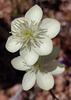
Now, we had to cross Aravaipa Creek 5 times, but we'd forgotten our water shoes back where we'd stashed our packs, so we took our shoes off for each crossing so that we wouldn't be stuck with wet boots. The roadwalking along Aravaipa Rd. went quickly, and was made much more enjoyable because of all of the wildflowers. There were tons of Cream Cups, lupine, chicory, and bladderwort on the hillsides. We passed a junkyard with interesting sculptures made out of car and motorcycle parts. We turned off onto FR94, and picked up our backpacks and filled our water from our cache for the following evening and the next day. The maps said that there was only a short walk in the wash before climbing onto a ridge that would take us to Reef Tank. We decided to make camp in the wash before climbing out, so that we would save the climb for the early morning hours. We had dinner, and went to bed fairly early.

Judy was already asleep, and I was writing in my journal. I hadn't turned on my GPS, leaving the navigation up to Judy. When I got my GPS out to put a waypoint for our first camp, to my surprise (and I'm a little embarrased to admit), we weren't on the GET at all! We were on FR94, thankfully only about a half-mile away from where we needed to be, but shocking nonetheless. I had been told by Brett Tucker that this was one of the most navigationally challenging parts of the whole Grand Enchantment Trail. Which is why I had brought Judy along in the first place, to have another set of eyes to search for the trail. And here we were making a complete newbie blunder like not paying attention to the guidebook and making a mistake on a roadwalk. I had to laugh at ourselves.

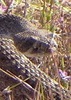
Day 2- As soon as I heard that Judy was up, I informed her of our mistake, and we both couldn't believe it. I figured it was a wake-up call for us to pay close attention to our guidebook. We went back and managed to get on the correct road, 50 feet east of FR 94, and began our climb up into the Santa Teresas. The foothills were covered in wildflowers- some of the lupine and poppies were so thick it made the hillsides change colors, and there were many Winding Mariposa Lilies. We reached the National Forest Boundary, and blew right past our turnoff onto singletrack. When we realized it, about a quarter of a mile later, we turned back around. I'm glad we initially missed the turnoff, because as we came back down the road, there was a beautiful Gila Monster. Gila Monster sightings are pretty rare, because they spend 95% of their time underground. And that's where this guy went after I'd shot a couple of pictures.

We went back to the Forest Boundary and turned off the road onto the Reef Basin Trail, just north of a very faded wooden sign. We contoured into Laurel Canyon, and were pleased to see water running in the creek. The trail was in pretty good shape, and in confusing parts there was usually a piece of orange flagging tape (even if it was just a small nub) to show us the way. Brett Tucker, the person who pioneered the Grand Enchantment Trail, re-flags the trail while thru-hiking it most years. This flagging was probably from a year ago, and we were thankful for whatever shreds were left. There were fields of white, blooming Cliff Fendlerbush lining the trail in Laurel Canyon, and soon after, we made one last climb to reach Reef Tank. We took a nice, long break for lunch and birdwatching.

I saw the weirdest thing- a bat flying in the middle of the day, swooping down to eat insects off the top of the water. Judy said that it was probably rabid. The next leg of our trip took Holdout Trail from Reef Tank to Holdout Canyon. The turnoff for Holdout Trail is only marked by a small cairn on the north side of the tank, not even a faded sign. Holdout Canyon is one of the places I had been dying to see- one of the reasons I got interested in the GET in the first place. The trail took us in and out of five drainages with some of the largest Manzanita and Alligator Junipers I have ever seen. Finally, we turned a corner and there it was: https://www.youtube.com/watch?v=XjHu4KPbT04

What a beautiful place! It was everything that I had hoped it would be, as well as much more vast than I had expected. We hiked toward Holdout Creek, and I found a perfect spot for camp, right before the trail dips to meet Holdout Creek. We had a great view of all the fantastic rock formations as well as Cottonwood Mountain, which we would be hiking on Day 4. I explored the rocks near our campsite, and found a perfect perch to watch the colors and shadows change as the sun set.

Day 3- What a wonderful thing to wake up in Holdout Canyon! It is close to the new moon, so sleeping under the stars last night was spectacular. This morning, I went exploring around Holdout Canyon for a couple of hours, while Judy stayed in camp and journaled. I absolutely love this place and its fantastic rock formations, fragrant juniper trees, deep blue skies. I found a great rocky perch with a view and enjoyed some alone time. I am usually a solo hiker, and I don't think I've ever been on a five day trip with someone before. Judy and I met several years ago through her website Hiken Girls, which has journals from her Arizona Trail hike that she finished in 2008. We corresponded a bit before I started my Arizona Trail hike, and when I did the passage from Oracle to the Gila River, I found a note that she'd left for me sitting on a cairn in the middle of nowhere! Judy and I have never backpacked together before, but thankfully our hiking paces and styles seem to mesh well.

On my way back to camp, I decided to institute Sirena's Cairn Rehabilitation and Beautification project (rebuilding fallen cairns or adding a small decorative rock on top). Judy and I packed up and got ourselves ready for what I had heard was the most overgrown and navigationally challenging part of this segment. I had brought leather gloves to attempt to protect my hands from scratches from the catclaw and other thorny plants- as a massage therapist it would be unsightly to go back to work with shredded hands. We were surprised to see that the rock formations in Holdout Canyon were so extensive- they went on for miles and miles. We maneuvered our way as the faint trail wove in and out of rocky outcrops on the north side of Holdout, searching for cairns, pieces of flagging tape, and stopping often to read and re-read the intricate notes in the guidebook. At times, the catclaw and live oak was so tall and thick it obscured the trail on the other side. I would hate to be caught out here in shorts and a t-shirt. Judy and I were enjoying the routefinding- each cairn and flag was a clue to solve the puzzle of how to get through to Black Rock Canyon.

We finally saw Black Rock Canyon in the valley below, and the trail took us back to Holdout Canyon just before the confluence. I have never seen an area so thick with animal prints of every kind! Mountain lion, bobcat, coyote, ringtail, deer, all clearly visible in the damp sand of the drainage. From our camp to the confluence, we were moving at about a mile an hour, because of brush and routefinding. We were happy to reach the Black Rock Trail, which wasn't a trail at all, but instead followed in the bottom of the drainage, which had a nice flow running through it. We crossed a fence into the North Santa Teresa Wilderness and promptly came upon a group of cows and calves. At about 6pm, we passed a flat area with a good sitting rock and a juniper tree and decided to set up camp. Even though we didn't make as many miles as we had been expecting, it had been an exciting day with lots of challenges and the amazing scenery was well worth it. We both tried not to think of all the mountain lion prints we'd seen as we went to bed. What a day- this was some of the most interesting, challenging, and beautiful miles I've ever hiked. I look forward to coming back to this area to explore more in the future.

Day 4- Judy and I got an early start and we continued following the twists and turns of the Black Rock drainage. Black Rock itself finally came into view. The scenery changed dramatically with dark brown and red rock formations Judy said, "Here comes a dog- it's a pitbull." Well, this beautiful brown and white dog was so excited to see us and was one of the most submissive dogs I've ever seen. He was a juvenile, all excited to have someone to play with, and flopped down, belly-up to show that he meant no harm. We missed our turnoff into Preacher Canyon, which resulted in a beautiful little detour into a small narrows of Black Rock Canyon. After we got back on track and started climbing up Preacher Canyon, we tried to tell the dog to go home several times, but he would just hide behind a bush and we'd see him a minute later, slinking up behind us. Finally, he got the hint and went back to where he'd come from. In Preacher Canyon, we followed a water pipeline trail and then had a stint of cross-country travel to attain a ridge. The whole hillside was filled with blooming fairy duster and Lilies. The view from the ridge was fantastic!

https://www.youtube.com/watch?v=6-ZC3_EjWOs

Judy realized she had cell phone reception on the ridge so she called her mom and I called my husband, Brian. I carry a SPOT satellite messenger, so our families had been getting OK messages twice a day. SPOT OK's are no substitute for conversation, though, and I was glad to be able to talk to Brian and assure him that everything was going ok with our trip. For the rest of the day, we were headed uphill, toward our highpoint of the trip at 7250 ft. on the crest of Cottonwood Mountain.

The tread was good on the way up to Kane Spring, which made the climbing easier. We stopped for a snack and water break, and realized that we probably weren't going to make it up to the highpoint to camp before dark. I had wanted to carry water up for a dry camp, but that would have to wait for another trip. Our next water source was 3.5 miles and almost a thousand feet higher on the mountain, and we had good tread and cairns until the gate at the saddle. Past that, there were quite a few newly downed trees and overgrowth in an area that had burned in the 1980s. I missed a switchback when we were getting close to our camp, which resulted in a scary-steep traverse on crumbly rock and a bushwhack straight up the hill to regain the trail. The last third of a mile to camp was exhausting. We finally heard water and found a flat spot to set up next to the trail. It had been a long, hot day with a tough climb and we were both beat.

Day 5- Judy and I woke up and got out of camp as early as we could- we had 9 miles to hike to Judy's car, then about 60 miles of dusty dirt-road driving to get my car and get out of here, then another two hours to get home. Fortunately, it was going to be mostly downhill today, so we had some hope of not having to drive the long dirt roads in the dark. First, we had a short climb to our highpoint, with amazing views of where we'd spent the last five days.

https://www.youtube.com/watch?v=4lcmz-v_3U4

It was somewhat overcast, which made for great conditions, as the terrain became more and more exposed as we dropped in elevation. The trail down Cottonwood was in great shape, and was welcome after all the brush fighting we'd done over the past 4 days. There were fields of fragrant blooming Desert Ceanothus on the way down from Cottonwood Mountain. The trail reached Cottonwood Canyon and we made a wrong turn and followed a cow path for a short distance before realizing we were off track. I was pushing through some brush and thought I was all the way through, but I came up and got a branch to the face! Fortunately, it only scratched my nose and lip- I could have broken my nose or lost an eye. After we got back on trail, we reached a beautiful waterfall where we sat for our lunch break.

After our break, we soon reached the boundary of the Santa Teresa Wilderness and FR 677, which we took to a 4wd track that continued in Cottonwood Canyon. There was water in the canyon, but it was very polluted by cattle- I was glad I filled up before the wilderness boundary. The two-track wound through boulder fields and crossed and recrossed the creek. We saw a lot of wildlife: deer, 2 zone-tailed hawks, numerous songbirds, and this hilariously fat horned lizard.

We reached Judy's car at about 2:30 and drove over to my car at the Aravaipa East TH. I was very happy with my choice of hiking partners and I think Judy may have caught the Grand Enchantment Trail bug. Though we could see rain off in the distance, there was none in our area, which was good because I had to drive my T-Bird across Aravaipa Creek five times to get out of there. It was 38 miles of good, recently graded dirt road through the Sulphur Springs Valley to Bonita, where I finally turned onto blacktop again. Total miles hiked (including inadvertent scenic detours and some exploring) was only 40 miles in five days. I feel very lucky that I got to experience this remote, wild, and beautiful place.

Here's a link to the full set of pictures from this trip: http://picasaweb.google.com/desertsiren ... directlink
 Culture
 Culture [ checklist ]
[ checklist ]  HAZ - Hike HAZard
_____________________
 
Aug 28 2009
avatar

 Guides 1
 Routes 3
 Photos 1,610
 Triplogs 49

41 male
 Joined Nov 18 2005
 
Cottonwood Mountain Trail #66 - Santa TeresasTucson, AZ
Tucson, AZ
Hiking avatar Aug 28 2009
nobert15Triplogs 49
Hiking7.00 Miles 1,950 AEG
Hiking7.00 Miles   8 Hrs      0.88 mph
1,950 ft AEG
 
1st trip
Linked   none no linked trail guides
Partners none no partners
Update to the directions: Once on the road marked "Sand tank 4 miles" You'll actually follow the signs for Forest Road 677, not 667. Also you'll make the first right about a mile down the road, if you keep following the most used route you'll end up at a radio tower as I did.

You'll probably want your 4-wheel drive after the first gate now, the road has probably deteriorated some since the directions were written. It's mostly decomposed granite though, so you wont have to worry about rocks gouging your underside. I made it in a stock 08 Jeep Wrangler with the S package. That means 31 inch Goodyear SR-A tires and 4-lo. I didn't have any problems or feel nervous at any time. I wouldn't take a full size pickup or anything without 4-wheel and decent clearance down there though.


As for the hike I didn't find the path hard to follow until getting up to the ridge. Just follow the cairns. There's a couple spots where there are multiple paths and cairns to follow, but they all eventually come back together. You can tell a lot of work was put into making the trail, it's too bad the forest service has quit maintaining all the trails in the range.

Once on the ridge to gain the true summit of Cottonwood is an exercise in frustration. There is a path in spots but it also disappears quite often, being overgrown with manzanitas. If you're wearing shorts be prepared to have your legs be torn up. The summit doesn't appear to see much use, the last summit register entry was from February 15th. It looks like several NOLS and SAHC groups used to go up there, but they haven't been signing it for the last couple of years.

There are some pretty amazing views up here of an oft ignored area. The range is between the much larger Pinalenos and the Galiuros with their much more famous history. I didn't see another person from the time I got onto Klondyke road until getting back to highway 70.

I did see a lot of wildlife up here. 3 rattle snakes, another tan colored snake I couldn't identify, 1 buck and 3 does, along with several scorpions and rabbits.

After visiting the Santa Teresas I definitely want to check out Holdout Canyon and Blackrock, so if anybody has any info could you please let me know? We could even plan a trip. I will not be coming back out in the summer though, it was hot!
wildflower observationwildflower observationwildflower observationwildflower observationwildflower observation
Wildflowers Observation Isolated
_____________________
 
average hiking speed 1.52 mph

WARNING! Hiking and outdoor related sports can be dangerous. Be responsible and prepare for the trip. Study the area you are entering and plan accordingly. Dress for the current and unexpected weather changes. Take plenty of water. Never go alone. Make an itinerary with your plan(s), route(s), destination(s) and expected return time. Give your itinerary to trusted family and/or friends.

helpcommentissue

end of page marker