username
X
password
register
for free!
help
ArticlesGuidesRoutes
 
Photosets
 
 Comments
triplogs   photosets   labels comments more
Chinaman Trail #137 - 9 members in 15 triplogs have rated this an average 3.7 ( 1 to 5 best )
15 triplogs
login for filter options
Nov 25 2023
avatar

 Guides 73
 Routes 176
 Photos 10,174
 Triplogs 2,324

46 male
 Joined Sep 08 2006
 
Chinaman Trail #137Tucson, AZ
Tucson, AZ
Hiking avatar Nov 25 2023
JimTriplogs 2,324
Hiking9.15 Miles 1,627 AEG
Hiking9.15 Miles
1,627 ft AEG10 LBS Pack
 
1st trip
Partners partners
PrestonSands
A cold moist and overcast day for this loop hike in the eastern Ritas. Some people enjoy that, but it was quite cold. Ironically, at least 2 of us considered postponing a day, but neither of us followed through on the thought. The forecast did claim it would be nice by noon. Somehow, it got worse.

We lacked the time and motivation to hike the Gardner Canyon Trail uphill to the Super Trail. The upper sections near the Super Trail is probably the most scenic section of trail.

Not a bad little loop, though the drive to get you there is more than would be ideal to access it. Excellent views of Josephine, Wrightson, the crest all the way to Florida Peak.
 Named place
 Named place [ checklist ]
[ checklist ]  Bear Spring

water 1 out of 5water less than maxwater less than maxwater less than max Bear Spring Dripping Dripping
Quite a little pool to use. No flow noted.

water 1 out of 5water less than maxwater less than maxwater less than max Tunnel Spring Dripping Dripping
There was water in the tunnel. No real flow noted. Would be easy to filter.
_____________________
🍭
 
Nov 25 2023
avatar

 Guides 170
 Routes 148
 Photos 5,914
 Triplogs 2,097

48 male
 Joined Apr 12 2004
 Tucson, AZ
Chinaman Trail #137Tucson, AZ
Tucson, AZ
Hiking avatar Nov 25 2023
PrestonSandsTriplogs 2,097
Hiking10.50 Miles 1,627 AEG
Hiking10.50 Miles
1,627 ft AEG
 no routes
1st trip
Partners partners
Jim
Jim and Brian and I left rainy Tucson and carpooled down to the east side of the Santa Ritas on a stormy and chilly morning, parking my truck at the Arizona Trail/Chinaman Trail trailhead. We headed south on the Chinaman Trail, following the route of an old mining flume/canal. The occasional warmth of the sun soon vanished for the remainder of the day, and occasional short lived drizzles became the norm. This was my first time on this trail, and I enjoyed the green hillsides of oak, pinyon and juniper, far reaching views to the Whetstones and Huachucas, and, for the cactus fanatic in me, Echinocereus rigidissimus aplenty.

Big Casa Blanca Canyon brought the first tall pines, while high above the canyon storm clouds hung low and heavy over Josephine Peak and Mount Wrightson, dragging drooping boils of snow flurries across their summits. We took a lunch break at Bear Spring (located west of where the USGS topo shows the spring), and then began ascending the south slope of the canyon. Interesting sandstone beds along the way were reminiscent of Coconino Sandstone and this section reminded me a bit of Mogollon Rim hiking.

The climb ceased at Walker Basin Trail junction, where we turned north to follow it across the eastern slopes of Josephine and Wrightson. A couple of drainage crossings actually held a little bit of water, a surprise given how dry the summer was.

We reached Gardner Canyon Trail late in the afternoon and began the last leg, dropping into the piney goodness of Gardner Canyon. Nice forest in here. Trail transitioned into road, darkness arrived, and we finished the last half mile by headlamp.
Arriving back in Tucson we stopped for dinner at Filiberto’s before heading home.

Definitely a cold one, but the stormy skies and winter like conditions were a neat change of pace. Good hike.
 Named place
 Named place [ checklist ]
[ checklist ]  Josephine Peak
_____________________
"…you never know when a hike might break out" -Jim Gaffigan
 
Apr 23 2023
avatar

 Guides 110
 Routes 2,246
 Photos 8,982
 Triplogs 2,600

45 female
 Joined Dec 24 2007
 Ahwatukee, AZ
Mt Wrightson from Tunnel Spring TH, AZ 
Mt Wrightson from Tunnel Spring TH, AZ
 
Hiking avatar Apr 23 2023
LindaAnnTriplogs 2,600
Hiking16.77 Miles 4,185 AEG
Hiking16.77 Miles   9 Hrs   1 Min   2.06 mph
4,185 ft AEG      52 Mns Break
 
1st trip
Route Scout Route Recorded  on Route Scout | Pop | Map | Popup | MapDEX
Matt and I got started from the Tunnel Spring trailhead just before 0700. Headed south on Chinaman Trail (which now seems to be called Ditch Mtn trail per the FS website). Easy hiking on Chinaman, with nice views. Got on Walker Basin and headed generally north. Somewhat steeper, but still fairly easy and good views. Matt claimed there were only three switchbacks on that portion of Walker Basin, but I think he adopted common-core math, because there were wayyyy more than three.

The real climbing began once we were headed uphill on Gardner Canyon trail. Slow going, and the heat did not help. The trail is in good condition, just not much shade. Super Trail was nicer, and still had some patches of snow alongside the trail. I actually put some snow under my hat in order to cool off. Took a snack break at Baldy Saddle before heading up to the summit. A few more patches of snow, but no problem.

Quick stop at the summit, there were seven hippies up there, which is not my thing. Easy descent, then retraced our steps back down to Gardner Canyon which we took all the way down to the truck.

Zero deadfall the entire way today, and all trails were in good shape. The road in is in good shape, with a few warer crossings. As long as you have 4+” of clearance, you’re good, although it would be tedious in a sedan. Good day, although it was a little warm at times.

water 1 out of 5water less than maxwater less than maxwater less than max Baldy Spring Dripping Dripping
Springbox was full. Minimal flow.

water 1 out of 5water 2 out of 5water less than maxwater less than max Bear Spring Quart per minute Quart per minute
Trough was full, light flow from the pipe
_____________________
Stop crying and just go do the hike.
 
Apr 23 2023
avatar

 Guides 11
 Routes 123
 Photos 818
 Triplogs 257

62 male
 Joined Jul 14 2011
 Tucson, AZ
Mt Wrightson via Chinaman Trail, AZ 
Mt Wrightson via Chinaman Trail, AZ
 
Hiking avatar Apr 23 2023
Mountain_RatTriplogs 257
Hiking16.77 Miles 4,185 AEG
Hiking16.77 Miles   9 Hrs   1 Min   2.06 mph
4,185 ft AEG      52 Mns Break
 
no photosets
1st trip
Whine-fest 2023

Ok, so pretty much what Linda said - [ triplog ] - but in my defense, the underrepresentation of switchbacks was intentional, just my way of softening the reality that there was actually a dizzying number of them. I would also add that once the uphill started, the sniveling did as well. It was hot & mostly breeze-free the whole trip. I blew through a ton of water (about 4 liters) and took on a pretty good sunburn. On the positive side, the views were great 99% of the way and the trails below the Super were empty. Some highlights included a most bizarrely manicured section of the Walker Basin trail which appeared to have been raked as a final touch, a Whitetail doe and her fawn, and views of Josephine Peak that can only be taken in along this route.

As per usual, it shook out to be a fine day in the end. Thanks for driving down Linda. I'll try to come up with something a little less sunny next time.
_____________________
🥓🥓🥓
  3 archives
Jan 07 2021
avatar

 Guides 187
 Routes 989
 Photos 12,068
 Triplogs 864

72 male
 Joined Jun 27 2015
 Tucson, Arizona
Tunnel Spring Trail, AZ 
Tunnel Spring Trail, AZ
 
Hiking avatar Jan 07 2021
markthurman53Triplogs 864
Hiking7.53 Miles 460 AEG
Hiking7.53 Miles   3 Hrs   55 Mns   2.07 mph
460 ft AEG      17 Mns Break
 
1st trip
Linked   linked  
Partners partners
mamakatt22
Ginny and I did a portion of the Arizona Trail along the Chinaman Trail. We started at Tunnel Spring in Gardner Canyon and hiked to Bear Spring in Big Casa Blanca Canyon, returning the way we came. This is a nice level hike with the exception of the very first part where you hike up over a hill as you leave Garner canyon and hike to the tunnel, about 100 feet. The next bit of climb is to Bear Spring which is about another 100 feet. All along the trail are views to to East of the Whetstone, Mustang and Chiricahua Mountains. To the west looming high up are Mount Wrightson and Josephine Peak. Big Casa Blanca Canyon where the canal ends is quite impressive with the large rock outcrops on the south side of the canyon. Bear Spring is about a quarter mile up trail from where the Chinaman Trail crosses Big Casa Blanca Creek and the canal ends, There is a sign posted along the trail. The spring box is about 30 yards downhill from the trail, follow the user path to the spring. There was about a quart per minute flow into the tank. The only other water seen along the trail was in the tunnel at the start of the hike and at the trail head in Gardner Canyon.

The road conditions to the trail Head were good, reachable by any high clearance vehicle. There was one other couple at the trail head doing the same trail we were doing. It is archery deer season so there were other vehicles along the Gardner Canyon Road.

water 1 out of 5water 2 out of 5water less than maxwater less than max Bear Spring Quart per minute Quart per minute
Trough was full of good clean water.

water 1 out of 5water 2 out of 5water less than maxwater less than max Tunnel Spring Quart per minute Quart per minute
Coming from pipe alongside the trough in Gardner Canyon.
_____________________
 
Nov 21 2020
avatar

 Guides 10
 Routes 673
 Photos 7,281
 Triplogs 4,660

67 female
 Joined Nov 17 2008
 phoenix, az
Temporal Gulch - AZT #4Tucson, AZ
Tucson, AZ
Hiking avatar Nov 21 2020
trekkin_geckoTriplogs 4,660
Hiking22.88 Miles 3,779 AEG
Hiking22.88 Miles   8 Hrs   51 Mns   2.88 mph
3,779 ft AEG      55 Mns Break
 
1st trip
Linked   linked  
Partners partners
johnlp
conditions looked perfect for a dayhike of azt passage #4 saturday
utilized ken's shuttle service again, setting out from patagona around 0730
chilly temps, but soon enough shed layers on the uphill road walk
the road wasn't that bad, good scenery and smooth sailing to start with
once the road narrowed and dropped into temporal gulch, it was more interesting
took a break around the ten mile point
solid uphill to the saddle on walker canyon trail, then a welcome descent on chinaman trail
these were very nice trails, and we enjoyed the pine trees and views of wrightson up close
passed bear spring, where john filtered a liter and we took another break
eventually the terrain changed back to grasslands, with interesting scenery along gardner canyon
passed tunnel spring and the beginning of the pipeline
finished up around 1620
i was about a quart low at this point and it took me awhile to rehydrate - note to self :?
good hike, especially the half on actual trails
it's been fun doing these passages with john, and hopefully one more before i get busy at work in december
thanks, lp!
 Culture
 Culture [ checklist ]
[ checklist ]  Windmill
 Named place
 Named place [ checklist ]
[ checklist ]  Bear Spring

water 1 out of 5water less than maxwater less than maxwater less than max Anaconda Spring Dripping Dripping
water running across the road
a pool down lower, which was fouled with cow poop

water 1 out of 5water 2 out of 5water less than maxwater less than max Bear Spring Quart per minute Quart per minute
upper pool was full of good water
tank was full with spigot dripping, but water looked murkier there

water 1 out of 5water 2 out of 5water less than maxwater less than max FS 72 Stock Tank 26-50% full 26-50% full
covered in algae - ick

water 1 out of 5water 2 out of 5water less than maxwater less than max Tunnel Spring Quart per minute Quart per minute
john said there was water inside

_____________________
hazhole
 
Nov 21 2020
avatar

 Guides 1
 Routes 14
 Photos 7,202
 Triplogs 5,208

68 male
 Joined Mar 16 2008
 chandler,az
Temporal Gulch - AZT #4Tucson, AZ
Tucson, AZ
Hiking avatar Nov 21 2020
johnlpTriplogs 5,208
Hiking22.88 Miles 3,779 AEG
Hiking22.88 Miles   8 Hrs   51 Mns   2.88 mph
3,779 ft AEG      55 Mns Break
 no routes
1st trip
Linked   linked  
Partners partners
trekkin_gecko
Kelly and I decided this AZT segment could be done as a long day hike. We got a shuttle ride from the end of the segment on Gardner Canyon Road to the beginning in Patagonia where we started our hike.
Kelly mentioned a road walk to begin the hike, but I had no idea it would last for 3 hours! The scenery was interesting enough that it passed by relatively quick.
Lots of sycamore and cottonwoods once we reached Temporal Gulch. No water right now as expected with the continued dry spell.
Once we entered the Mount Wrightson Wilderness, the landscape is heavily wooded with oaks and evergreens. Very pleasant hiking. We saw a bird that looked like a grouse run off the trail into the brush. Descending next to Bear spring that has clear water. Filtered water there and had snacks.
The final few miles are back down into grasslands and oaks on good tread.
Good to finish another AZT segment. Fun hike. Thanks Kelly! :)
 Named place
 Named place [ checklist ]
[ checklist ]  Anaconda Spring
_____________________
“Good people drink good beer.” Hunter S Thompson
 
Apr 04 2020
avatar

 Routes 6
 Photos 15
 Triplogs 4

51 male
 Joined May 22 2013
 Tucson, AZ
Chinaman Trail #137Tucson, AZ
Tucson, AZ
Hiking avatar Apr 04 2020
sparkspackTriplogs 4
Hiking4.40 Miles 1,019 AEG
Hiking4.40 Miles
1,019 ft AEG
 no routes
1st trip
Linked   none no linked trail guides
Partners none no partners
Just a quick trip up the trail and back to get out of the house. Clear day and a fair amount of water that we have not seen before on prior trips that crossed the trail about half mile in and then again at about 2 miles in. The creek was flowing in the Casa Blanca drainage and the weather was great. In all this is a great trail to take new hikers and elementary age kids on but my teens still enjoyed it. The road in was dotted with more camping than I have ever seen in the past and the creek in Gardner was running strong. The last 2 miles may be tough, because the road crosses Gardner creek a few times, on a low clearance vehicle but not an issue for a Subaru or more capable. The tunnel that has signage had water in it as usual and we passed a father and son section hiking the AZT. nice trip not to far from Tucson.
wildflower observationwildflower observationwildflower observationwildflower observationwildflower observation
Wildflowers Observation Isolated

water 1 out of 5water 2 out of 5water less than maxwater less than max Bear Spring Quart per minute Quart per minute

water 1 out of 5water less than maxwater less than maxwater less than max Tunnel Spring Dripping Dripping
_____________________
 
Feb 02 2019
avatar

 Triplogs 3

67 male
 Joined Nov 15 2016
 Green Valley AZ
Chinaman Trail Loop, AZ 
Chinaman Trail Loop, AZ
 
Hiking avatar Feb 02 2019
AFMerriamTriplogs 3
Hiking10.00 Miles 1,120 AEG
Hiking10.00 Miles   7 Hrs      1.67 mph
1,120 ft AEG   1 Hour    Break12 LBS Pack
 no routesno photosets
1st trip
Partners none no partners
Temperature when I started out from Tunnel Springs was in the low 50's and overcast. With the wind I really needed a long sleeve shirt and pants. My Whippet wore his jacket on the whole trip. There were a few intermittent sprinkles but nothing that required my rain shell. I finished the hike to Bear Springs fairly quickly so I decided to continue on and make a loop of it.

The hike to Bear Springs along the Chinaman Trail #137 was easy. There is no reason for rest breaks on this trail. Since the trail is part of the Arizona National Trail, it is well maintained. The net elevation gain is very slight, maybe a 100 feet. Bear Springs is well marked. It is about 100 yards after you start uphill, just after a stream crossing.

The extension to the Chinaman trail from Bear Springs to Walker Canyon Trail Junction took some effort but not too much. The elevation gain was 800 - 900 feet over a mile and a half. Once again, trail conditions were excellent.

The Walker Canyon Trail conditions are not so good but still very passable. This is not surprising since I heard it is "closed" since the forest fire came through years ago. Some helpful folks put some trail markers (piled rocks) in some spots. You shouldn't have any problems finding your way. There are some downed trees across the trail and those dammed thorn bushes make life rough on people with short pants. The pines are recovering; in time they will shade the thorn bushes out. The erosion is not bad at all. Parts of this trail are made up of loose rock which is hard on my feet. It is a 500 feet gain of elevation over 2.3 miles.

From there it's all downhill. This portion of the Gardner Canyon #143 trail continues to be rocky. It has a few trees but is definitely a maintained trail. Once you leave the wilderness area, you hit the old trail head which is a fence gate. From there you walk down an overgrowing road which has been closed for quite a while until you hit the new trail head. From there it is a 1 mile walk down FR 785 to Tunnel Springs.

It was a nice trip. I did see signs of bear, coyote, and bobcat. Remember I'm 60 and overweight. If I can do this hike, so can you.

Oh one more thing. Ignore the description on the Coronado Forest sight. It was written before the Arizona Trail and consequently has you scrambling across country. ](*,)
_____________________
 
Dec 09 2018
avatar

 Guides 12
 Routes 192
 Photos 863
 Triplogs 356

42 male
 Joined Nov 30 2015
 Phoenix, AZ
Temporal Gulch - AZT #4Tucson, AZ
Tucson, AZ
Run/Jog avatar Dec 09 2018
ShatteredArmTriplogs 356
Run/Jog24.40 Miles 3,916 AEG
Run/Jog24.40 Miles   6 Hrs   57 Mns   3.62 mph
3,916 ft AEG      13 Mns Break
 
1st trip
Partners none no partners
AZT Passage 4 was the first one I did solo. Drove to Patagonia, with an arrangement to get picked up by my sister at the end of the passage. The first half (or more) of the passage is just on Temporal Canyon Road - pretty lame, views are OK, but it's graded forest road. When I did it, part of the road was closed due to an environmental cleanup project, so I had to do a very worthwhile diversion along jeep roads and cow paths. They should make this a permanent part of the trail, because it's more interesting than forest road.

After rejoining the road, the climb steepened a little bit, and I was pretty done with it by the time I got to Walker Basin TH. There was shade and water there, so it was nice.

Took a nice long break at the high point, at the junction where AZT starts heading down into Casa Blanca Canyon. Texted my sister with an ETA. Stopped and filled up my water at the creek crossing. This was really a beautiful little canyon, with some worthwhile views as it contoured away from the creek.

Once hitting Gardner Canyon Road, I was back in familiar territory (from the Old Pueblo races). Pushed through the last few miles, think it was worse than it was when I was finishing up the 50 miler.

Hard to say whether this segment is awesome or totally sucks, depends on whether you're talking about the road or trail part. North of Walker Basin TH it's pretty great.
_____________________
  1 archive
May 07 2016
avatar

 Routes 17
 Photos 2,773
 Triplogs 249

53 female
 Joined May 15 2009
 Phoenix and Tucs
Chinaman Trail #137Tucson, AZ
Tucson, AZ
Hiking avatar May 07 2016
cindylTriplogs 249
Hiking6.60 Miles 1,019 AEG
Hiking6.60 Miles
1,019 ft AEG
 no routes
1st trip
Linked   none no linked trail guides
Partners partners
southpawaz
we were camping at camp site number 1 along gardner canyon road and i couldn't believe how few people were camped out there. the weather was perfect, save just a bit of wind. i looked at the map and discovered there was a little hiking trail from tunnel spring to bear spring - it didn't look too difficult, so we committed to doing that one (and we drove right to the trailhead). a lifetime ago i remember doing a hike with a meetup group that randy led - return to ditch mountain. i was kind of hoping to go up the mountain again to earn the peak beer that i packed, but bobby wasn't into it. the hike was perfect for us, since we hadn't been doing much recently - not too much elevation, so we made pretty good time on this one. i didn't actually see the bear spring, but we enjoyed a break at the creek, where i had a non-peak beer in the shadow of mount wrightson.
 Named place
 Named place [ checklist ]
[ checklist ]  Bear Spring  Mount Wrightson
wildflower observationwildflower observationwildflower observationwildflower observationwildflower observation
Wildflowers Observation Isolated
saw a couple of cactus that were just about to pop: very upsetting that the claret cup and the rainbow cactus weren't showing yet. the new mexico thistle were out, and some scattered verbena.

water 1 out of 5water 2 out of 5water 3 out of 5water 4 out of 5 Bear Spring Gallon + per minute Gallon + per minute
lots of water in the creek

water 1 out of 5water 2 out of 5water 3 out of 5water 4 out of 5 Tunnel Spring Gallon + per minute Gallon + per minute
lots of clear water in the tank
_____________________
There are just two switchbacks left. And another half-mile to the destination...
  3 archives
Nov 15 2014
avatar

 Routes 36
 Photos 2,658
 Triplogs 1,347

67 male
 Joined Jul 28 2004
 Scottsdale, AZ
Temporal Gulch - AZT #4Tucson, AZ
Tucson, AZ
Hiking avatar Nov 15 2014
mazatzalTriplogs 1,347
Hiking13.10 Miles 2,250 AEG
Hiking13.10 Miles   5 Hrs   30 Mns   2.54 mph
2,250 ft AEG      20 Mns Break
 
Partners partners
BobP
JuanJaimeiii
Bob had done the first part of AZT #4 so we recruited a buddy with a vehicle better than a Ford to help us :roll: Thanks JJ!

We parked after driving in about 8.5 miles and continued up to the high point of this section at about 6300’ - cool area with a few ponderosas and nice views. From there we descended down to the water system that carried water 8+ miles to Greaterville - fascinating stuff! Finally descended down into Gardner Canyon - lots of nice car camping sites down there with a few in use. Saw 5 deer in Gardner and we got to use two new gates less than a week old :lol: Thanks Shawn

This section was better than I expected I didn’t know all the detail on the mining history and the flora was nice and varied across the elevation change.

JJ picked us up at Apache Springs not long after we arrived. We stopped for Tacos in Tucson (thanks Bob) and DQ in Casa Grande ;) A grand day out on the AZ Trail - thanks guys :y:
foliage observationfoliage observationfoliage observationfoliage observationfoliage observation
Autumn Foliage Observation Isolated
_____________________
  1 archive
Mar 21 2014
avatar

 Guides 19
 Routes 40
 Photos 5,624
 Triplogs 341

52 female
 Joined Nov 22 2005
 Tucson, AZ
AZT Passages 4-5, AZ 
AZT Passages 4-5, AZ
 
Backpack avatar Mar 21 2014
writelotsTriplogs 341
Backpack20.43 Miles 3,119 AEG
Backpack20.43 Miles1 Day   6 Hrs   6 Mns   
3,119 ft AEG
 
1st trip
It was my hope from the very beginning that I’d be able to share a bit of the glory and adventure of Sirena’s through hike on the AZT. The fact that I am insanely envious barely plays into it at all (wink). So, when my schedule shifted about a bit and opened up an opportunity for me to not only join her for Passage 4 but to take her family camping afterwards in my travel trailer, King Gilbert, I was ecstatic! An overnight on the AZT…with my celebrity friend…just the two of us and the foothills of the Santa Rita mountains on one of the most beautiful weekends of the year? Oh yeah. I’m in!

Passage 4 of the AZT follows the Temporal Canyon Road in Patagonia for the first 13 miles. For most through-hikers, road walks are similar to unwanted chores: often necessary, rarely enjoyed. Sirena had taken care of the first 7 miles of the road walk the day before to speed things up, so we had only about 6 miles to go before we truly got off into the wilds. Luckily, even road walking in this area can be scenic and rewarding. Winding through the oak forests and over the pools of Temporal Gulch wasn’t such a horrible chore at all – and the terrain offered enough distraction to keep us contented as we hoofed along.

Throughout our walk on the road, we were amazed at the amount of water that we were finding. The spring boxes were full, and there was often a slow trickle in the bottom of the canyon. Although it has been an unusually dry (and warm) winter and early spring in southern Arizona, it seems that a few well-timed storms have really helped out these riparian areas. It’s unlikely that the pools will remain long without more moisture coming from the sky and soon – but it was a real treat to know that we would not have to worry about running dry on this particular piece of trail.

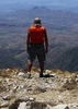
Once we turned off onto the Walker Basin trail and got back to our preferred single-track hiking, the mountains rewarded us with even better vistas and diversity. Mt. Wrightson, the highest mountain in the Santa Rita range, is topped by Baldy Peak at 9,453 ft. This barren, granite summit presides over the entire range like a patriarch, and it’s steep wooded flanks have always called to those seeking solitude and adventure. Both Sirena and I have visited the summit on multiple occasions – but somehow it’s even more impressive to see the mountain this way – wandering about at it’s base staring up. Although the Arizona Trail does not climb to the top of this range as it does with the Rincons and the Santa Ritas further north, it does provide hikers with an intimate experience with Wrightson just the same.

16 miles into Passage 4 (9 for us today), we arrived at Bear Spring. Our initial plans were to camp near the spring, as Sirena had often wanted to but schedule often didn’t permit. The spring is a beautiful spot – cold, clear water from the tank and a sycamore-studded stream babbling just down the hill in Big Casa Blanca Canyon. There were some ideal tent sites near the creek, and plenty of trees for my hammock. We took our hiking shoes off and dunked our feet in the icy creek, filtered and drank our fill of the delicious water and considered our options. It was still early in the day, with hours until sunset, and our feet now felt refreshed and ready to go again. We decided that while the spring was an ideal spot, we’d take our chances on the trail ahead and keep moving just a little while longer. Besides - we knew there was a group of high-school students hiking the opposite direction who were supposed to be staying at Bear Spring as well that night, and we really didn't want to be all settled in when they crashed (if they were coming).

Luckily, we found them just a few hundred yards down the trail, camped in a large spot beside the creek. Now we knew where they were, we could camp in confidence that we'd not be disturbed by "eager young minds" that night.

Beginning at Bear Spring, the trail follows a historic drainage feature called a “flume”. This ditch was dug into the mountainside in the early 1900′s as a part of an effort to provide water to a gold mining operation in nearby Kentucky Gulch. Water from Bear Spring was diverted into the flume and ran in the ditch for 2 1/2 nearly level miles to the next improvement at Tunnel Spring. Because of this historic engineering effort, the trail feels almost dead-flat, and contours high above the steep floor of Big Casa Blanca canyon. At one point, Sirena began telling me, it’s supposed to duck through a hole in the rock – but she missed the spot back in 2008 by accidentally taking the bypass built for equestrian use. She was just finishing the story when we came around a corner and found the “hole-in-the-wall” – a small tunnel through the conglomerate rock that makes up the canyon walls. Her excitement made passing up the Bear Spring camp 100% worthwhile!

As the sun got lower in the sky, we began to look for a spot to camp. Since the trail is carved into the mountainside, we started to scan the ridges and slopes that ran perpendicular to the trail for a spot. I spotted a faint foot-path heading off onto one such ridge, and we followed it out to one of the finest campsites we could have hoped for. A small fire ring, cleared spots for ground sleepers, trees for hammocks and drop-dead amazing views to the south, west and east. We arrived just in time to settle in before the evening light show started, then made ourselves a modest fire and ate Thai green curry chicken and rice by its glow. For girls like Sirena and I, it simply does not get any better.

The next morning we didn’t get an early start (which is SO typical of us!), but we were on the trail in plenty of time to cover the 10 miles remaining to our base at Kentucky Camp. We had more historic flume hiking ahead, followed by a series of small ups and downs along the historic water system, and ending with a short but wearing road walk from Kentucky Camp to my trailer just down the road. We were low on food (Sirena’s finally got a through hiker’s appetite), and eager to get back before her family arrived at camp. Never the less, we hardly hurried. The trail is just too much fun to rush!

By the time we caught sight of Kentucky Camp, we were hungry and a little tired in the feet - ready to kick back and relax. It was good that from the same ridge where we first spotted the buildings, we could also see King Gilbert - full of food and promising sandals and chairs. We were on a mission!

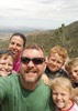
Seeing her family's reaction to my choice of campsite was hilarious. It was a busy weekend in the grasslands, and the larger, more established sites had already been taken when I arrived Thursday night. However, I picked out a spot on a ridge with 365degree views - but no existing fire ring or bare dirt. Where do we camp? Where do we make a fire? I lead them through the steps of building the fire ring and that process stamped down the tallest grasses immediately around the trailer. By sunset, they were as in love with the spot as Sirena and I had been. Just took a little "getting used to" the Arizona way of things ;)

I took my hammock down the hill to the nearest copse of trees for my hang that night and slept with a contented smile. What a great weekend on the Arizona Trail!
wildflower observationwildflower observationwildflower observationwildflower observationwildflower observation
Wildflowers Observation Isolated
One spot of poppies, Dichelostemma capitatum scattered, cacti looking like they're starting to bud out.

water 1 out of 5water 2 out of 5water less than maxwater less than max Anaconda Spring Quart per minute Quart per minute
Pool full and clear with a little alge

water 1 out of 5water 2 out of 5water less than maxwater less than max Bear Spring Quart per minute Quart per minute
Beautiful water!

water 1 out of 5water less than maxwater less than maxwater less than max Big Casa Blanca Canyon Pools to trickle Pools to trickle

water 1 out of 5water 2 out of 5water less than maxwater less than max Tunnel Spring Quart per minute Quart per minute
Tank full of clear water

water 1 out of 5water 2 out of 5water 3 out of 5water less than max Upper Walker Tank 51-75% full 51-75% full
_____________________
-----------------------------------
Change will not come if we wait for some other person or some other time. We are the ones we've been waiting for. We are the change that we seek.- Barack Obama
 
Oct 22 2013
avatar

 Guides 187
 Routes 989
 Photos 12,068
 Triplogs 864

72 male
 Joined Jun 27 2015
 Tucson, Arizona
AZT #4 Walker Basin to Gardner Canyon, AZ 
AZT #4 Walker Basin to Gardner Canyon, AZ
 
Hiking avatar Oct 22 2013
markthurman53Triplogs 864
Hiking19.40 Miles 2,562 AEG
Hiking19.40 Miles   7 Hrs   49 Mns   2.85 mph
2,562 ft AEG   1 Hour    Break15 LBS Pack
 
1st trip
Partners none no partners
Portion of Arizona Trail #4 from Gardner Canyon to Walker Basin. This is a Round trip hike with almost all elevation gain from North to South (Gardner Canyon to Walker Pass). If you go down to Walker Basin there is a 600 foot climb back out. There was water along the trail in Cave, Gardner and casa Blanca canyons. Very interesting trail with a lot of History along the way. There is a lot more information about this canal system on the internet. Great views of Mount Wrightson and Josephine Peak.
_____________________
 
Feb 07 2013
avatar

 Photos 261
 Triplogs 8

78 male
 Joined Feb 02 2012
 Green Valley, AZ
Chinaman Trail #137Tucson, AZ
Tucson, AZ
Hiking avatar Feb 07 2013
ArizonaBobTriplogs 8
Hiking4.40 Miles 1,019 AEG
Hiking4.40 Miles
1,019 ft AEG
 no routes
1st trip
Linked   none no linked trail guides
Partners none no partners
We wanted to do a less strenuous hike in preparation for tougher adventures as the weather warms. Reading the description by BrettVet, it looked like the Chinaman Trail was perfect.
Turns out, the Jeep drive to the trail head was more of a challenge than the trail :-)
Would strongly suggest high clearance four wheel drive, and 'airing down'.
From Tunnel Spring, the trail seems to go up the mountain, then down to the tunnel entrance. GPS showed a 140 foot drop to the tunnel through loose gravel (and if you hike out and back, you must go UP this part to get back to the parking area).
GPS recorded round trip of 6.6 miles in 4:06 hrs.
A good hike with historical significance along the Arizona Trail.
 Named place
 Named place [ checklist ]
[ checklist ]  Bear Spring  Tunnel Spring
_____________________
 
average hiking speed 2.38 mph

WARNING! Hiking and outdoor related sports can be dangerous. Be responsible and prepare for the trip. Study the area you are entering and plan accordingly. Dress for the current and unexpected weather changes. Take plenty of water. Never go alone. Make an itinerary with your plan(s), route(s), destination(s) and expected return time. Give your itinerary to trusted family and/or friends.

helpcommentissue

end of page marker