|
| | | |
| |
|
| Hiking | 5.50 Miles |
1,400 AEG |
| | Hiking | 5.50 Miles | | | |
| 1,400 ft AEG | | 45 LBS Pack | | |
|
|
| |
| Linked |
|
none
[ show ]
| no linked trail guides |
| Partners |
|
[ show ]
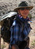
| partners | | Headed up here with azpride and some of my family for a "rugged" adventure. Boy did it deliver. The experience in the group ranged from never camping to many backpack/canyoneering adventures and everything in between. The out of town family asked for "rugged" and I took them to the eye of the storm  Anyone heading this way, feel free to CONFIRM directions! PM me if needed, better yet I'll put together a map to avoid mass confusion. Anyone heading this way, feel free to CONFIRM directions! PM me if needed, better yet I'll put together a map to avoid mass confusion.
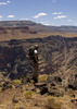
Once to the trailhead the entry shoots SE and is the classic CG style "trail". I will say this, if you don't hit the choke stone crawl space in the first 15 minutes, your not on the right path. This is the spot where all members went "oh crap" in only a way Arizona can get make you say. We removed our packs and one by one slid through. After this point its switch backs and a steep graded route. Azpride is an excellent route finder and we never had a cairn to far out of site. Rout finding is not cheap in this neck of the desert, so be prepared. There are a few relative "flat areas" to view the canyon floor but not to much to see at this point. In about 1.5 hrs we reached a small scramble that is somewhat difficult with a pack on due to your wait transfer over a ledge 100-200 ft about the canyon floor. Once over its boulder hopping and creek bottom time.
The next .75 mile is large boulders and drainage bed. It's somewhat average at this point but, no worries, it gets better and much narrower as you head towards the river. 1.5 mile to go to the river and the dry-falls start to appear. Did I mention the sun was down at this point  ? Should have left a bit earlier ? Should have left a bit earlier  The moon and headlamps lead the way quite nicely. A few more dry-falls and a geological change happens gradually. A few scrambles and butt slides are inevitable, it adds to the charm. At one one point, to avoid the muddy pool, we all had to hug a wall and tip toe one by one around. I went last and , well, became one with the mud The moon and headlamps lead the way quite nicely. A few more dry-falls and a geological change happens gradually. A few scrambles and butt slides are inevitable, it adds to the charm. At one one point, to avoid the muddy pool, we all had to hug a wall and tip toe one by one around. I went last and , well, became one with the mud  Again, it only added to the charm of the canyon Again, it only added to the charm of the canyon  Finally, as the canyon narrows there is an impassible dry-fall about .5 miles from the river. This is where the narrows begin. We were all exhausted at this point, so azpride scouted ahead and finally came back from the darkness and said, "this is the way around!" A scramble up to the left, and onto a trail 5 ft wide and 70 ft drop to your right. NEATO, except it was idiotic to do at night, and with packs. After tempting fate we all decided to set up camp. Among the boulders are some great sandy spots, so we made home. The mood went from "Killing Jon" to good libations real fast. Freeze dried food,craft beer, laughter, and sleep. All in that order. Finally, as the canyon narrows there is an impassible dry-fall about .5 miles from the river. This is where the narrows begin. We were all exhausted at this point, so azpride scouted ahead and finally came back from the darkness and said, "this is the way around!" A scramble up to the left, and onto a trail 5 ft wide and 70 ft drop to your right. NEATO, except it was idiotic to do at night, and with packs. After tempting fate we all decided to set up camp. Among the boulders are some great sandy spots, so we made home. The mood went from "Killing Jon" to good libations real fast. Freeze dried food,craft beer, laughter, and sleep. All in that order.
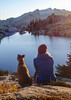
The next day we ventured into the narrows, again nicely cairned route. We all were relieved we didn't take the left route down at night, this is by far the hardest/scariest part of the trip. Once past this section its all good from here. Honestly I was taken aback at the sheer beauty, as I think we all were on that same page. Giant pools of water and red toned jagged rocks fill this area. A must see IMO. Right before the "wading pool" you feel like your in a Grand Cathedral. The wading pool is mandatory so prepare to get wet. It was up to my waist, so gauge depending on recent rain. After wading through the large pool its only 20 more, completely beautiful, minutes to house rock rapids. This beach is as live-able as it is camp-able. The whole group stood in awe of the mighty Colorado. I realized that I was the only one who had seen it up close. It was like Christmas morn and everyone just opened the best gift ever received. Rafters guided through the rapids flawlessly as we watched. This beach is a real gem.
The way out is so much easier, save for the good 'ol AZ sun. That should be expected in this country though! We then headed to the north rim for a night of coooooollld car camping and my birthday chili
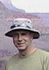
Elisha(her first camping/backpack experience ever!), Aimee, Liz, Andrew, David, Joel and I wont forget that anytime soon! |
| _____________________
| | |
|
|
|
 Route Editor