|
| | | |
| |
|
| Hiking | 6.80 Miles |
2,143 AEG |
| | Hiking | 6.80 Miles | 20 Hrs | | 0.76 mph |
| 2,143 ft AEG | 11 Hrs Break | 22 LBS Pack | | |
|
|
| |
| Partners |
|
none
[ show ]
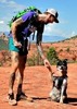
| no partners | | This is a little overnight backpacking trip I did. As far as Sedona backpacking, I really enjoyed this series of trail for a few reasons: 1) water! Several cattle tanks along the route meant I didn't have large carries OR go thirsty 2) solitude! Jack's Canyon, Munds Mtn, and Schnebly Hill trail are reliably quiet, the popular Munds Wagon Trail is quite tolerable after a night of backpacking in the Munds Mtn Wilderness. 3) the VIEWS! As a Sedona resident I can be a little "vista'ed out" sometimes but the views from Munds Mountain are truly something else.
I started my trek at the Jack's Canyon/ Hot Loop trailhead near Village of Oak Creek. The walk to Jack's Canyon Tank is fairly boring to me personally as it is mostly flat, exposed, and freckled with expensive homes nearby. The tall grasses here landed my dog 3 ticks the first time we came out. I fill up a little extra water at Jack's Canyon tank to get me up to Munds Mountain as I've found the drainages/ pools further up to be unreliable. I should stress that this water is HEAVILY FILTERED as I am currently using an MSR Guardian that pump clear water from very bad sources. Some people might not be comfortable with water sourced from livestock tanks.
After the tank, the trail hits the wilderness boundary and follows a pretty drainage through Jack's Canyon all the way to the saddle at Munds Mountain. This part of the trail is reliably shaded and cool though the trail itself can be faint and easy to lose in parts. Keep an eye out for cairns and footprints. The climbing picks up a bit and really amplifies in the stretch up to the saddle at Munds where you will be rewarded with some good views back towards the interstate and Horse Mesa. Atop the saddle is a junction for Schnebly Hill Trail, Hot Loop, and Munds Mtn.
The trail up Munds is very faint, steep, and rocky for the first few hundred yards. Once back in the pines there is a small clearing looking out towards the San Francisco Peaks, Oak Creek Canyon, and the closer red rocks around Mitten Ridge/ Cowpies/ Merry Go Round that would make a good place to camp or snack. I pushed on towards Munds Tank and bushwhacked from there to my own campsite overlooking Sedona/ Airport Mesa/ the Black Hills.
Walking back down to the junction for Schnebly Hill trail/ Hot Loop/ Jack's Canyon and taking the route for Schnebly Hill trail will take one past the Schnebly tank to fill up on water for the downhill trek back to Sedona. I ended my hike at the Munds Wagon Trail trailhead where I had a ride pick me up but there is no reason you can't walk into Sedona. A nice alternate might be to hike up to the Schnebly Hill vista and take Huckaby down to the 89a and catch a ride into town from there. |
| _____________________
| | |
|
|
|
 Route Editor