| | -
-
-
-
-
| |  |
|
2 |
-
| |  |
|
1 |
-
-
-
-
-
-
-
-
-
|
| | |
|
| Hiking | 4.50 Miles |
200 AEG |
| | Hiking | 4.50 Miles | | | |
| 200 ft AEG | | | | |
|
|
| |
| Linked |
|
none
[ show ]
| no linked trail guides |
| Partners |
|
none
[ show ]
| no partners | | Water Report: Get out there!
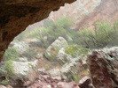
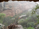
I went out today on a fact finding mission to see how all the recent rain affected the creeks. I did an out and back to Hackberry Spring, plus a little exploring up First Water. To start, instead of walking down the road from the horse lot, I just climbed over the railing and took the use trail that heads north from the corner of the lot. I always wanted to see where that came out. I would highly recommend this trail as an alternative to the route listed here. It is much more scenic and you avoid the long, steady climb up the hill coming back. Very soon into it, this trail splits - stay to the right. It winds through some very pretty red, pink and orange rock between the hills. Much of it is a wash, which was mostly dry on the way out, but after today's rain, it was almost a stream on the way back. Between the storm last week and again this week (I had the pleasure of hiking through both of them), the water level looked like late February. I had to duck under a boulder for 45 minutes during the thunder portion of today's storm, but it was a great day to hike - cool, wet and bug free. I enjoyed every minute! The water was rushing everywhere - music to my ears. There was not a stagnant pool to be seen. The ground was saturated and water was still running good down all the slopes when I left so it won't disappear overnight. I can only vouch for this area, but I would bet that all the creeks in the Supes are renewed...an encore of late winter, but not as chilly! Take advantage of this before the oven door opens! |
| _____________________
I'm at home in the wilderness... it's civilization I have problems with! ](https://hikearizona.com/dex2/images/smilies/eusa_wall.gif "Brick wall") |
| | |
|
|
|
|
|
| |
 Route Editor


