| | -
-
-
-
-
| |  |
|
1 |
-
-
-
-
-
-
-
-
-
-
|
| | |
|
| Hiking | 23.60 Miles |
4,350 AEG |
| | Hiking | 23.60 Miles | 9 Hrs 44 Mns | | 2.87 mph |
| 4,350 ft AEG | 1 Hour 30 Mns Break | | | |
|
|
| |
| Partners |
|
none
[ show ]
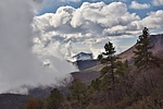
| no partners | | Same idea as last summer with two basic goals: hike the length of Gaddes and Burnt Canyons and find a better route down from West Rim to Powerline. With the cold front coming and going the day before, it seemed like a good day for water in the creeks and clouds above and below View Point Trail. Ended up super good timing and maybe the best day I've spent on Mingus. Started at Mescal Tank with North Mingus.
North Mingus and View Point had been trimmed back since the summer, so rain and snow melt on the trailside brush was mostly a nonissue. A little muddy but nothing too bad. North Mingus a mix of forest and views. Clouds below to the north were even better once on View Point. Walked above, below, and inside them until topping out on Mingus.
Quarter inch of snow on top of Mingus Mountain that had mostly melted by sundown. Gaddes Canyon had a trickle in the snowy top of the trail and below the road on Black Canyon Trail. Once into Black and Burnt Canyons the flow picked up. Not too strong but more than a trickle. Clouds rolled overhead the whole way. Burnt canyon is mellow with a better and better forest heading up. The upper mile or two is picture perfect open ponderosa forest. The middle section had some smooth, rocky sections that are awesome with water flowing. The going is relatively easy the whole way, not much to maneuver around or bushwhack through.
Diverted from the end of Burnt Canyon up to the tank North of Kendall Peak. On the way noticed a pair of graves with a metal sign that read "Ram Dog" from which a grey collar hung. Walked the road with some corner cutting to Yaeger Cabin Trail. Passed the only person I saw all day on Yaeger Canyon and then commenced the mile or so roadwalk to Butterfly. Straight through the woods from Middle To West Rim and then over to the edge of the mountaintop.
I took a ridge NW off the very northern tip of the mountain. It was a way better track down than last time, and though a moderate bushwhack I was on Powerline in twenty minutes. On the way down enjoyed views of Humphreys and Sedona that shine in the last couple hours of the day. Straightforward trip back down. On the day saw the one person, two coyotes, a half dozen deer, and lion tracks near the upper Black Canyon TH and Mingus Lake. |
  |
Gaddes Canyon |
Light flow |
Light flow |
| | | Pools/trickle higher up, below the road light flow | | | |
|
|
|
|
|
| |
 Route Editor


