| | -
| |  |
|
1 |
|
| | |
|
| Hiking | 13.74 Miles |
1,666 AEG |
| | Hiking | 13.74 Miles | 6 Hrs 13 Mns | | 2.45 mph |
| 1,666 ft AEG | 37 Mns Break | | | |
|
|
| |
| Linked |
|
none
[ show ]
| no linked trail guides |
| Partners |
|
none
[ show ]
| no partners | | Entered this adventure with limited knowledge of the area. Created the main page to help assist others whom may have interest or are unaware these trails exist.
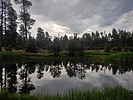
Easy hike to where you must turn L or R. You are now on trail described on main page. Turning L allows you some milage. A ways down I spotted 3 deer. Monsoons are common up here. Worth it for the temp drop which continued post storm.
The end of this trail is at a dirt road where there were campers & an ATV buzzing around. The opposite side ends in a neighborhood as does the parallel trail. The only steep, rocky section was connecting under the power lines. |
| | |
|
|
|
|
|
| |
 Route Editor


