| | -
-
-
-
-
-
-
-
-
-
-
-
-
-
| |  |
|
4 |
|
| | |
|
| Hiking | 2.60 Miles |
1,173 AEG |
| | Hiking | 2.60 Miles | 2 Hrs 16 Mns | | 1.34 mph |
| 1,173 ft AEG | 20 Mns Break | | | |
|
|
| |
| Linked |
|
none
[ show ]
| no linked trail guides |
| Partners |
|
none
[ show ]
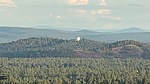
| no partners | | Decided to hike up Wing Mountain today as there were five geocaches located at the top and crater rim trail. Drove to a dispersed camping area near East Wing Tank and started up. First 0.2 follows a Jeep road, which then turns into a trail, only for it to end and become a bushwhack. Followed some game trails for a bit, until I realized it would be better to go mostly straight up compared to switchbacking. So from 8100’ to 8400’ I went up, then I found a trail, which I know now to be the rim trail that goes around the crater along the rim. Followed this trail up all the way to the survey disks. Found the main disk along with Reference Mark 1 and 2. I also found evidence of an old height of light. Continued along the rim trail around till I reached the high point and found a summit log and signed it. There also were some business cards in there, advertising someone’s hiking YouTube channel. A strange way to advertise a YouTube channel. Continued along the rim trail and eventually made my way down into the crater. Not much in the crater and didn’t see any evidence of a possible fire tower that was mentioned in someone else’s triplog. Hiked straight down, being careful not to slip. Slope was rather steep. Enjoyable hike.
Here’s a video I took of the survey disks, summit log, and views while hiking Wing Mountain if you’re curious what exactly is up here.
[ youtube video ] |
| | |
|
|
|
|
|
| |
 Route Editor


