username
X
password
register
for free!
help
ArticlesGuidesRoutes
 
Photosets
 
 Comments
triplogs   photosets   labels comments more
Cottonwood Trail #247 - 32 members in 138 triplogs have rated this an average 3.4 ( 1 to 5 best )
1, 2, 3, 4, 5 ... 7  Next
138 triplogs
login for filter options
Feb 15 2026
avatar

 Guides 37
 Routes 569
 Photos 10,973
 Triplogs 1,067

male
 Joined Jan 21 2013
 AZ
Skull Mesa from Spur Cross THPhoenix, AZ
Phoenix, AZ
Hiking avatar Feb 15 2026
FOTGTriplogs 1,067
Hiking15.57 Miles 3,345 AEG
Hiking15.57 Miles   6 Hrs   44 Mns   2.43 mph
3,345 ft AEG      20 Mns Break
 no routes
Partners none no partners
I went back to Skull Mesa on Sunday. I took the shorter approach to the Mesa this time and then descended off of the western slopes of the mesa towards the Chalk Canyon area and the Cave Creek Trail. A little steep near the top, but manageable. A light flow in Cave Creek. A dry crossing is possible with some light rock hopping. I did not see anyone all day until I got back to within about a mile of the trailhead. The trailhead seemed quiet for a Sunday, maybe the five dollar entry fee is scaring people away.
wildflower observationwildflower observationwildflower observationwildflower observationwildflower observation
Wildflowers Observation Light
A few modest stretches of poppies and the usual spring stuff.

dry Chalk Canyon Dry Dry

_____________________
 
229458
Feb 01 2026
avatar

 Guides 37
 Routes 569
 Photos 10,973
 Triplogs 1,067

male
 Joined Jan 21 2013
 AZ
Skull Mesa from Spur Cross THPhoenix, AZ
Phoenix, AZ
Hiking avatar Feb 01 2026
FOTGTriplogs 1,067
Hiking15.70 Miles 3,492 AEG
Hiking15.70 Miles   6 Hrs   38 Mns   2.63 mph
3,492 ft AEG      40 Mns Break
 no routes
Partners none no partners
It’s been a long time since I have been up on Skull Mesa, (December 15, 2014 to be exact). The last time I did it was during a backpack out there with the dog. I think the last visit felt like less of a slog than today. The trails were in excellent shape all the way to the mesa. We walked around some on top and explored the area a little more thoroughly than the last time I had been up there. After nearly two miles of walking around on the mesa, we headed back down and returned the way we hiked in. I enjoyed getting out to stretch my legs some, after being cooped up for a bit, but I think I will try the more direct route up Mariposa Hill next time. A nice light flow in Cave Creek. Dry crossings were possible with rock hopping.
 Named place
 Named place [ checklist ]
[ checklist ]  Dirt Trough Creek
wildflower observationwildflower observationwildflower observationwildflower observationwildflower observation
Wildflowers Observation Isolated
A few poppies along the trail here and there.

water 1 out of 5water less than maxwater less than maxwater less than max Dirt Trough Creek Pools to trickle Pools to trickle
water report recorded in the field on our app Route Scout
_____________________
  1 archive
229121
Jan 31 2026
avatar

 Guides 4
 Routes 237
 Photos 114
 Triplogs 234

male
 Joined Aug 08 2020
 Phx az
Cottonwood Trail #247Phoenix, AZ
Phoenix, AZ
Hiking avatar Jan 31 2026
ScaredyCatTriplogs 234
Hiking15.56 Miles 2,204 AEG
Hiking15.56 Miles   8 Hrs   3 Mns   2.32 mph
2,204 ft AEG   1 Hour   21 Mns Break
 
no photosets
1st trip
Linked   none no linked trail guides
Partners none no partners
apparently this member prefers to keep an air of mystery...
Route Scout Route recorded on Route Scout | Pop | Map | Popup | MapDEX
 
229148
Feb 09 2025
avatar

 Guides 19
 Routes 313
 Photos 1,974
 Triplogs 292

female
 Joined Mar 11 2002
 Gilbert, AZ
Skull Mesa RuinsPhoenix, AZ
Phoenix, AZ
Hiking avatar Feb 09 2025
VashtiTriplogs 292
Hiking14.96 Miles 3,143 AEG
Hiking14.96 Miles   10 Hrs   15 Mns   1.76 mph
3,143 ft AEG   1 Hour   45 Mns Break
 
1st trip
Route Scout Route recorded on Route Scout | Pop | Map | Popup | MapDEX
Headed out at 6a for a 7a start. It was nice and cool with a bit of wind. After paying our $3, we were off! We saw the Rangers just getting things set up.

We opted to take the shortcut to shave off a mile. Not sure if this area is closed? The posted sign seems to point to yes, but if you took the shortcut going towards the parking lot, you would never see the closed sign, only a cairn marking the start of the trail from Cottonwood trail 247. From the Spur Cross trail/road, you turn right following the signage for mariposa hill.

The shortcut follows the park boundary fence line for quite a while. There are good views of the mansion houses and their roads during the climb up the ridge. The trail is mainly well defined with only a few sections that are faint. After the shortcut lets out onto Cottonwood trail 247, it is not too far until the gate and junction with skull mesa 248. At the beginning, there seems to be multiple trails, but after a while they all merge, and up to the Mesa you steeply go. The trail is good, but I was definitely happy to be heading onto the flat ground of skull mesa. We had a quick snack break and headed off across the mesa through dry grass, rocks, and prickly pear. The game trails are much appreciated. I was thinking how fast and pleasant this trip would be on an actual trail, ha! Of course then there might be hordes of people. We made it across the Mesa without incident and started over to the ruins. Everything was relatively uneventful except for a 15 ft long section of exposure which I didn't love while passing the last mound on the left (southeast) side before the ruins. This appeared the best way to go, but 5-inch wide trails plus dropoffs are not my fave. After the sketchy section, we enjoyed the ruins.

I was hoping for us to do a loop with Cave Creek trail 4 after coming down from the ruins. Well. A lot of triplogs go up/down by the ruins. These people are part mountain goat and FAR more fearless than me. I was studying the way down based on the route I downloaded. And any way I looked at it, it looked frightening and steep! Apparently, I am not part mountain goat! 🤣🤣 It just looked like a scary cliff to me. We decided to head back the way we came. I had really wanted to make that loop, but we just couldn't find a way down that we were comfortable traversing. I was looking forward to being on trail after the scary down, but instead it was back across skull mesa and down down down back to the car. We passed very few hikers all day. We saw no one during most of the day, only a few people within a quarter mile of the parking lot plus one solo hiker headed up to the top of skull mesa as we headed down.

I was mighty disappointed not to have seen a single Petroglyph on skull mesa. I kept looking to no avail!! I will have to research more for next time.

It was an adventure on a new trail! A beautiful day to be out exploring! 😁☀️
_____________________
:D
  3 archives
221252
Jan 08 2025
avatar

 Guides 2
 Routes 251
 Photos 4,602
 Triplogs 3,281

male
 Joined Feb 26 2008
 Scottsdale, AZ
Quien Sabe PeakPhoenix, AZ
Phoenix, AZ
Hiking avatar Jan 08 2025
BobPTriplogs 3,281
Hiking7.95 Miles 2,124 AEG
Hiking7.95 Miles   4 Hrs   39 Mns   1.90 mph
2,124 ft AEG      28 Mns Break
 
1st trip
Partners none no partners
Route Scout Route recorded on Route Scout | Pop | Map | Popup | MapDEX
Started about 915ish in sub 50 degree weather. The high at the end was 58. The hike starts on trail 4 then crosses the road and the creek and then becomes a dirt road. I left the road headed towards the spring and stayed in the drainage for awhile. It was good until it wasn't. I headed out of the drainage and looked for a ridge to the cool peak. I love cows for many reasons but today because they opened up some pathways. There were also some game trails. The last climb up to QSM was so windy, I needed to take my hat off or risk losing it. The route off QSM was filled with shrubbery but not much catclaw. My hiking pole was my best friend today! My phone battery died a little before the end but RS saved everything up to then. Fun day!

water 1 out of 5water less than maxwater less than maxwater less than max Quien Sabe Spring Dripping Dripping
The box was about 3/4 full
_____________________
https://www.seeitourway.org
Always pronounce Egeszsegedre properly......
If you like this triplog you must be a friend of BrunoP
 
220334
Oct 26 2024
avatar

 Guides 2
 Routes 284
 Photos 10,346
 Triplogs 424

63 male
 Joined Dec 02 2014
 Mesa, AZ
Cave Creek Trail #4Phoenix, AZ
Phoenix, AZ
Hiking avatar Oct 26 2024
adillingTriplogs 424
Hiking11.03 Miles 1,129 AEG
Hiking11.03 Miles   5 Hrs   51 Mns   2.04 mph
1,129 ft AEG      26 Mns Break
 
1st trip
Linked   linked  
Partners partners
DarthStiller
Route Scout Route recorded on Route Scout | Pop | Map | Popup | MapDEX
Chris invited me to hit a couple of trails in the Seven Springs area. I haven’t been up in this area since the 1990’s.

We arrived right after sunrise and my truck’s dash was showing 41 degrees.

Chris wanted to hike from the Cave Creek trail over to the Cottonwood Trail and try to finish off the section he missed the week before. He came from the other direction and the trail was hard to follow. We hiked down to the creek, crossed and made it up the Skunk Tank/Cottonwood junction.

The trail was not “groomed”, but it was fairly clear. It looks like the official route for that one has been reclaimed by Mother Nature. The trail we followed was higher up on the ridge and stayed out of the wash. We hiked down about 1.5 miles before we turned around and headed back to the Cave Creek Trail.

The Cave Creek Trail follows Cave Creek right along the banks and then higher up when it gets further in. The riparian area was really nice. Lots of shady sections, water pools and some autumn leaves starting up on the cottonwoods and sycamores.

As it climbs out of shady creekside area, it started looking like I was hiking in the Superstitions. Saguaros started appearing and the creek became a canyon. We came across the only other humans we encountered as we climbed down to the creek.

Chris pointed out a cool crested saguaro right after we crossed the creek. Looks like the elements got it a little as one of the crested arms had fallen off. We hiked down another mile or two before we stopped for a snack break.

Hiking back, I could feel the heat and was longing for that 41 degrees we had at the start. When we got back to the trailhead it was showing 91 degrees on the dash, a 50 degrees difference!
This area is really nice, especially along the creek. I will have to come back when the water is flowing. Thanks for the invite Chris.
_____________________
"Jobs fill your pockets, adventures fill your soul."

instagram: @andydilling
 
218745
Oct 26 2024
avatar

 Guides 27
 Routes 713
 Photos 12,657
 Triplogs 897

56 male
 Joined Jul 05 2006
 Mesa, AZ
Cave Creek Trail #4Phoenix, AZ
Phoenix, AZ
Hiking avatar Oct 26 2024
DarthStillerTriplogs 897
Hiking10.90 Miles 1,427 AEG
Hiking10.90 Miles
1,427 ft AEG
 
Linked   linked  
Partners partners
adilling
It was a pretty chilly start, colder than the previous week at the same TH. Once the sun hit, however, it ended up much hotter than the previous week. I wanted to start out by hiking the north end of the Cottonwood Trail because when I did it last time a few years ago, it faded away and I couldn't find where it joined the Skunk Tank Trail. I expected we would go a half mile past the junction to where I kept the end of that track. Instead, as we approached that area, where we were was significantly far off from the official track. We hiked almost an extra mile to where our position matched the official track, and at that point it was very visible that the trail splits there. There is a plastic "247" marker, but the rerouted section of the trail looks less developed than the older abandoned section at that point. the new trail ascends as you go northbound, and the older trail descends into the wash and is much wider. Mystery solved.

that first part of the hike was mostly in the shade. As we got back to the north end of it, we were out in the sun. Along the first mile back on the Cave Creek Trail, we were in the shade of the trees, but then as the trail ascends after it crosses the creek, it was sun the rest of the day.

All the trails here are significantly rocky, which took its toll on my feet. The views inside the narrow canyon part of Cave Creek are very nice, but the climbs and descents on the ankle breakers made for slow going. We spotted the crested saguaro in this section of the trail, and half of the crest has fallen off.

We stopped at the creek crossing right before the Skunk Tank and took a break. Made our way back slowly as the temperature began to climb. We went up this way to try to escape the heat for this weekend and kind of did, kind of didn't.
_____________________
 
218758
Dec 10 2023
avatar

 Guides 9
 Routes 484
 Photos 8,583
 Triplogs 638

male
 Joined Dec 07 2010
 Phoenix, AZ
Cottonwood Trail 247-247A Loop, AZ 
Cottonwood Trail 247-247A Loop, AZ
 
Hiking avatar Dec 10 2023
Oregon_HikerTriplogs 638
Hiking
Hiking
 
1st trip
Partners none no partners
My daughter requested that I recommend a trail for a family hike and I came up with this one out of the Spur Cross Trailhead thanks to a triplog posted by @LosDosSloFolks. It was one of the few trails out of Spur Cross that they hadn't done before. The Spur Cross parking lot was nearly full when we started at 11:00am but once we got on 247A we didn't see another person until returning on the Spur Cross Trail following Cave Creek. I tested my fitness by trying to keep up with my 2 grandkids on the first uphill sections and had some success. But I was lagging behind on the last half of the loop and got back to the parking lot about 15 minutes after them.
 Named place
 Named place [ checklist ]
[ checklist ]  Elephant Mountain
_____________________
 
211568
Nov 18 2023
avatar

 Guides 94
 Routes 848
 Photos 22,732
 Triplogs 2,040

52 male
 Joined Sep 18 2002
 Tempe, AZ
Mattys Cave Creek Loop, AZ 
Mattys Cave Creek Loop, AZ
 
Hiking avatar Nov 18 2023
chumleyTriplogs 2,040
Hiking14.98 Miles 2,295 AEG
Hiking14.98 Miles   6 Hrs   56 Mns   2.33 mph
2,295 ft AEG      30 Mns Break
 no routes
1st trip
Partners partners
FOTG
John9L
We decided to get out and appreciate the weather, since you can hike on a dry sunny day any damn time you want here. It was raining so hard on the drive in that Rackensack Creek was unexpectedly flowing at the 24 crossing. Once on trail, steady rain eventually tapered off into occasional showers before stopping and turning into one of those sunny days we have plenty of.

Skunk Tank is a hella boring road walk. I forgot how long it is to get up and around. We decided to skip the side trip to the summit and headed south on QS250 until it crosses Mattys Fork. From here it was off-trail adventure. Occasional signs of an old route appeared on the banks but were overgrown. The rain made everything wet and hopping down the canyon bottom was the better option.

The old cabin lost its legs and will not remain standing much longer. Lee pushed for the western high route which led us far astray and got us into some tricky terrain getting back to the creek bottom. The lower half of Mattys is a bit more open than the upper half and travel was quicker here.

Back on CC4 we made good time heading upstream, enjoying the flowing water, and early fall colors, encountering a couple walking their horses through one of the rougher sections of trail -- the only people we saw all day.

Lee wandered around Ashdale in a figure-8 pattern to make sure he got the extra .02 miles to say he did 15 ;) A handful of deer were the wildlife highlights on the day. It's always a great day when you hike with somebody else who doesn't mind driving!
foliage observationfoliage observationfoliage observationfoliage observationfoliage observation
Autumn Foliage Observation Isolated
Early colors getting started in the drainages with a stretch of pure gold near the ranch.
_____________________
I'm not sure what my spirit animal is, but I'm confident it has rabies.
  2 archives
211009
Oct 30 2023
avatar

 Guides 9
 Routes 484
 Photos 8,583
 Triplogs 638

male
 Joined Dec 07 2010
 Phoenix, AZ
Off-trail Meander from Cottonwood Trail 247, AZ 
Off-trail Meander from Cottonwood Trail 247, AZ
 
Hiking avatar Oct 30 2023
Oregon_HikerTriplogs 638
Hiking4.80 Miles 750 AEG
Hiking4.80 Miles   5 Hrs      0.96 mph
750 ft AEG
 no routes
1st trip
Linked   linked  
Partners none no partners
My Grandson, Michael, and I went for a hike from the Spur Cross TH up Cave Creek to connect with the old Tonto Nat Forest trail #247 outside the park boundary. On the way we took the Spur Cross Mariposa Trail to the top of Mariposa Hill for the views. After entering the Tonto Nat Forest, we connected with the old #247 trail following it for about a quarter mile before heading off-trail to take a look at an old mine I had found there years ago and to search for evidence of ancient habitation. My Grandson prefers off-trail exploration to following maintained trails. Not sure where that came from, but I was more than happy to accommodate him. We were successful in meeting our objectives - finding the old baseplate of a stamping mill at the mine site, scattered pottery sherds on a low hillside bench along the east side of Cave Creek, and the crumbled rock walls of a single ancient habitation. After the hike we visited the Cave Creek Museum so Michael could see the restored 1910 10-stamp mill from the mines on Continental Mtn.
_____________________
  2 archives
210457
Feb 19 2023
avatar

 Guides 112
 Routes 2,442
 Photos 9,563
 Triplogs 2,793

45 female
 Joined Dec 24 2007
 Ahwatukee, AZ
Skull Mesa RuinsPhoenix, AZ
Phoenix, AZ
Hiking avatar Feb 19 2023
LindaAnnTriplogs 2,793
Hiking14.12 Miles 3,137 AEG
Hiking14.12 Miles   8 Hrs   2 Mns   2.11 mph
3,137 ft AEG   1 Hour   20 Mns Break
 
Partners partners
RedChrisB
Route Scout Route recorded on Route Scout | Pop | Map | Popup | MapDEX
I had met Chris at the summit of 5057 a few weeks ago, and we had coordinated a hike for today. Got started around 0700 and took the shortcut over to Cottonwood trail. Kind of humid on the ascent up to Skull Mesa. Fairly easy walking across the top, mostly just dodging prickly pear. Wandered around the ruins, then retraced our steps back down. Only saw two other hikers all day, until the final half-mile, then we saw about a dozen. Good day, although a littke warm, and good to hike with Chris.
_____________________
Stop crying and just go do the hike.
 
204024
Feb 04 2023
avatar

 Guides 12
 Routes 192
 Photos 886
 Triplogs 361

42 male
 Joined Nov 30 2015
 Phoenix, AZ
China Wall - Cottonwood Basin, AZ 
China Wall - Cottonwood Basin, AZ
 
Run/Jog avatar Feb 04 2023
ShatteredArmTriplogs 361
Run/Jog16.59 Miles 3,543 AEG
Run/Jog16.59 Miles   5 Hrs   52 Mns   2.91 mph
3,543 ft AEG      10 Mns Break
 
no photosets
1st trip
Needed something closer to town due to an evening commitment, so I found a couple friends brave enough to check out some abandoned routes. It also provided a reason to finally check off Bronco Trail. Got to the TH amid heavy gunfire, and when we got past the head of Seven Springs Wash, we were finally clear of the bullets flying around.

Bronco trail was prettier than I expected, views aren't bad. The turn onto the old Bronco Creek trail wasn't hard to find, and the trail wasn't terribly hard to follow to the corral. There were even fresh footprints, even beyond the corral.

After we passed the fence, there was no obvious route, and staying in the wash was the easiest path. Used the line on my topo to determine where to exit, and once up to the first saddle, the trail reappeared. There were stretches where we lost the trail, but overall, getting up to the Bronco Butte ridge was a lot more straightforward than expected. The China Wall structure was pretty cool.

Decided to do a short side trip up to Bronco Butte, since it didn't seem likely we'd have another chance any time soon. The west side had no trail we could find, but going parallel to the wall was easy enough, and dropped us right onto the Desert Mountain trail system, which provided a half mile or so reprieve from bushwacking.

Cottonwood Basin trail is basically nonexistent, but there was flagging from the FS boundary most of the way down to Cottonwood Creek. The brush wasn't terrible.

Once we got to the Cottonwood Creek trail, it got easier, and on this stretch I think we saw a majority of the runners attempting the 50 mile run. Even recognized a few faces.

Fun day, although those trails might be one and done for me.

water 1 out of 5water 2 out of 5water less than maxwater less than max Cottonwood Spring Quart per minute Quart per minute

dry Cottonwood Spring Dry Dry
Dry where the trail drops in, better flow a few minutes walk downstream.

dry Jack Springs Dry Dry
Didn't see anything, think it's being pumped out.
_____________________
 
203610
Jan 22 2023
avatar

 Guides 12
 Routes 192
 Photos 886
 Triplogs 361

42 male
 Joined Nov 30 2015
 Phoenix, AZ
Skull Mesa - Cottonwood Creek LoopPhoenix, AZ
Phoenix, AZ
Run/Jog avatar Jan 22 2023
ShatteredArmTriplogs 361
Run/Jog16.19 Miles 3,577 AEG
Run/Jog16.19 Miles   5 Hrs   4 Mns   3.34 mph
3,577 ft AEG      13 Mns Break
 
no photosets
1st trip
One of my friends has been wanting to check out Skull Mesa, and since I hadn't been up there in at least 5 years, I figured it'd be a good time to revisit it. I had done this same exact loop ~7 years ago. Cave Creek was flowing nicely, and temps were brisk in the AM. Once on Cottonwood Trail, it struck me how nice the condition of the trail is these days. They've also added 2-3 switchbacks since the last time I passed through.

The trail up Skull Mesa was still nice and rough. Passed a group of hikers coming down. At the viewpoint, my friends expressed their willingness to continue the loop, despite my warnings about the probably lack of a defined trail the next few miles.

Crossing Skull Mesa was rough as expected, with some mud, lots of hidden cactus, and hard-to-spot cairns. Lost the track the last little bit, but I knew roughly where the trail should drop off - and there was an impressively tall cairn to mark the location.

The next few miles were really a surprise - someone has cleared the Skull Mesa trail from the east rim all the way down to Cottonwood Trail. Some of the smoothest trail we encountered out there, and this section used to be a real route finding challenge (especially just east of the Qien Sabe junction). It's like a highway now.

At Cottonwood Spring, we took the shortcut back to Spur Cross, which by now seems well on its way to being reclaimed by nature. We did see a pair of hikers here, surprisingly enough. Eventually we arrived at the "Area Closed" sign at the end of Mariposa Hill trail (in my defense, there was no sign at the other end); felt nice to be back on a nice smooth path.

water 1 out of 5water 2 out of 5water less than maxwater less than max Cottonwood Creek Light flow Light flow
Intermittent flow near Cottonwood Trail

water 1 out of 5water 2 out of 5water less than maxwater less than max Cottonwood Spring Quart per minute Quart per minute

water 1 out of 5water 2 out of 5water less than maxwater less than max Cottonwood Spring Quart per minute Quart per minute

water 1 out of 5water less than maxwater less than maxwater less than max Dirt Trough Creek Pools to trickle Pools to trickle
_____________________
 
203185
Dec 27 2022
avatar

 Routes 34
 Photos 313
 Triplogs 42

87 male
 Joined Dec 11 2005
 Phoenix, AZ
Spur Cross Loop with Mariposa Hill #247 CC#4, AZ 
Spur Cross Loop with Mariposa Hill #247 CC#4, AZ
 
Hiking avatar Dec 27 2022
muskybankrTriplogs 42
Hiking6.75 Miles 1,239 AEG
Hiking6.75 Miles   3 Hrs   4 Mns   2.53 mph
1,239 ft AEG      24 Mns Break10 LBS Pack
 
1st trip
Partners none no partners
This is one of our favorite loops in the Spur Cross Mountains, utilizing some well-worn trails that don’t appear on my map but are obviously well known to the horses in the area. Start down Spur Cross about one mile to Mariposa Hill, following that as it joins the Tonto National Forest trails. At about the 2 mile mark you will arrive at a cairned intersection; the trail to the right leads to the old concrete water trough on Cottonwood but we turn left and go up the hill, less than a mile, on what we call the Shortcut trail which intersects Cottonwood trail at the 2.65 mile mark, just below Skull Mesa, where we turn left, reaching the Skull Mesa TH on the CaveCreek #4 trail, at near the 4.3 mile mark and from there it’s about 2.5 miles back to the parking lot. This shortcut cuts about 3 miles off the alternate route and about 1000 feet of AEG, both very helpful attributes of this trail, yet not side-stepping any of the scenic views in the Spur Cross Mountains. All photos by Phil
foliage observationfoliage observationfoliage observationfoliage observationfoliage observation
Autumn Foliage Observation None
Cottonwoods in Dragon Fly are golden
wildflower observationwildflower observationwildflower observationwildflower observationwildflower observation
Wildflowers Observation None
Some sort of pink ratany ground cover, if there is such a plant. Other than that, nothing I saw.
_____________________
 
201983
Dec 19 2022
avatar

 Routes 75
 Photos 3,143
 Triplogs 623

70 male
 Joined Feb 10 2019
 Cave Creek, AZ
Cottonwood Trail 247-247A Loop, AZ 
Cottonwood Trail 247-247A Loop, AZ
 
Hiking avatar Dec 19 2022
LosDosSloFolksTriplogs 623
Hiking6.78 Miles 1,068 AEG
Hiking6.78 Miles   3 Hrs   26 Mns   2.12 mph
1,068 ft AEG      14 Mns Break
 
Partners none no partners
Route Scout Route recorded on Route Scout | Pop | Map | Popup | MapDEX
Felt the need to hike in the boonies and this loop close to home was perfect. CCW loop starting from Spur Cross Ranch utilizing 247A and 247B in the Tonto National Forest to gain access to Cottonwood Trail 247. This took me back west to the creek and a return south to Spur Cross Ranch.

The tread conditions of 247, A, and B were the best I've ever seen. I credit and thank the horsemen for the much needed maintenance and erosion repair. There's still a lot of sticky, pokey, grabby things encroaching in places, so long pants are the better choice IMO. After the climb up to the junction of 247 I was feeling pretty good about my effort and the reward of being so isolated from my fellow man.

Thirty seconds later I ran into a hiker (in his mid to late 80's!) coming up 247 from the west. We both said we didn't expect to see another soul up here and had a laugh. He said I'd run into his wife who was lagging a half mile or so behind him. I did stop and chat with her also when we crossed paths. She was very surprised to see me too.
Hiking 247 from creek to the east is a tough uphill slog. I felt like genuflecting to them. :worthy: Sure hope I'm up there doing that in another 20 years!
 Meteorology
 Meteorology [ checklist ]
[ checklist ]  Autumn - Color Foliage
foliage observationfoliage observationfoliage observationfoliage observationfoliage observation
Autumn Foliage Observation Light
wildflower observationwildflower observationwildflower observationwildflower observationwildflower observation
Wildflowers Observation Isolated

water 1 out of 5water 2 out of 5water less than maxwater less than max Cave Creek - SPRCA Light flow Light flow

water 1 out of 5water less than maxwater less than maxwater less than max Cottonwood Creek Pools to trickle Pools to trickle

water 1 out of 5water less than maxwater less than maxwater less than max Dirt Trough Creek Pools to trickle Pools to trickle

water 1 out of 5water 2 out of 5water 3 out of 5water 4 out of 5 Metate Pond 76-100% full 76-100% full
_____________________
Surely not everyone was Kung Fu fighting?
  1 archive
201746
Oct 29 2022
avatar

 Guides 27
 Routes 713
 Photos 12,657
 Triplogs 897

56 male
 Joined Jul 05 2006
 Mesa, AZ
Cottonwood Spring Loop - Cave CreekPhoenix, AZ
Phoenix, AZ
Hiking avatar Oct 29 2022
DarthStillerTriplogs 897
Hiking10.08 Miles 1,861 AEG
Hiking10.08 Miles   5 Hrs      2.02 mph
1,861 ft AEG      1 Min Break
 
Partners none no partners
got started from Spur Cross after 6am. did the lasso counter clockwise. 247A is rougher than I remember it. Definitely moved slower along that trail mainly due to how rocky it is. It's faint in some spots, but still fairly easy to find.

the huge crested saguaro below 247 in the wash looks like it might be sick or dying. Looks like it's seen better days. the westernmost section of 247 I hadn't hiked in over 12 years, so it was like a new hike again to do that section.

saw a trail maintenance crew on 247 a mile or so east of the junction with the Cave Creek Trail. After that I began to see other hikers. Took Metate back instead of Spur Cross. The closer I got to the TH, the more hikers there were.

ended up doing 10 miles. Weather was cool and windy early on. got warmer once the sun hit, but not hot. Kept my sweatshirt on the whole time and didn't feel overheated.
_____________________
 
200458
Oct 22 2022
avatar

 Guides 27
 Routes 713
 Photos 12,657
 Triplogs 897

56 male
 Joined Jul 05 2006
 Mesa, AZ
Cottonwood Trail #247Phoenix, AZ
Phoenix, AZ
Hiking avatar Oct 22 2022
DarthStillerTriplogs 897
Hiking11.84 Miles 2,096 AEG
Hiking11.84 Miles   5 Hrs   27 Mns   2.17 mph
2,096 ft AEG
 
1st trip
Linked   none no linked trail guides
Partners none no partners
Started from the Bronco TH and headed west to the Cottonwood Trail and took that to the Skull Mesa Trail and headed back. I hadn't hiked that section of the Cottonwood Trail in almost 20 years.

The hike in was mostly shaded due to the low sun and being in the valleys. On the east out the sun was constant. Temps were chilly at the start and warmed up quickly. Didn't see any other hikers the entire time.

Early clouds made for nice pics with shadows and sunny skies later also helped. Finished before noon.
_____________________
 
200309
May 07 2022
avatar

 Routes 41
 Photos 64
 Triplogs 44

58 male
 Joined Mar 29 2015
 Chandler, AZ
skull mesa hike May '22, AZ 
skull mesa hike May '22, AZ
 
Hiking avatar May 07 2022
AndrewrdcTriplogs 44
Hiking12.83 Miles 2,970 AEG
Hiking12.83 Miles   6 Hrs   7 Mns   2.27 mph
2,970 ft AEG      28 Mns Break10 LBS Pack
 
1st trip
Partners none no partners
Great solo hike up to Skull Mesa! This was my first time hiking in this area just north of Cave Creek. First thing to know is that in order to access this area from the south, the trailhead begins at the Spur Cross Ranch Conservation. This gives you an additional 2-mile hike along an old jeep trail before reaching the Cottonwood trail or the Cave Creek #4 trailheads. At this entrance, there is a $3 fee (cash only!) paid via envelopes and an honor system but the fee is well worth it as the rangers do an amazing job managing the trails and park area! OK... lets get to the hike: I started hike at about 7:15am on a Saturday... as mentioned the first 2-miles or so is along Spur Cross trail... about half way along, you will leave the conservancy land and enter National Forest. This is an old Jeep trail that quickly becomes a nice, easy and well maintained trail. Once you get to the Cottonwood trail, the fun begins. Over the next 3 miles, total AEG is only about 700', and the trail is easy to follow, though its definitely rocky and undulating. This was, for me, a very enjoyable trail... great hiking with total solitude. At about the 5 mile mark, you get to a fence (see pic) and your opportunity to head north (and UP) along Skull Mesa Trail (#248) to ascend to the top of Skull Mesa. I must admit, I stood there for a few minutes contemplating my options. The mesa is high and intimidating... 1,000' up over a single mile This is where your training and cardio will kick in. During my contemplation, along came the first other hiker I had seen all morning... Mark and I chatted for a few minutes and (maybe out of shame) I made my decision and started up Skull Mesa trail. This trail is not quite as clear but easy enough to follow if you pay attention. Yes, it is a tough assent, but elevation was gained quickly so it was actually not as difficult as it looked. Reaching the top of Skull Mesa is well worth it... amazing views in almost any direction and I even found a little shade to sit and have lunch (pic). After about :30 min of R&R and realizing that it was going to be approaching 100 degrees by the time I got back to my car... I started my descent.

Unfortunately, all the creeks and marked water sources were bone dry except for one area (ironically, unmarked) along cave creek just before Cottowood trailhead where there was still a large shallow accumulation of water in the wash (pic)... unfortunately, I dont expect anything will be left in a week or two.

All in all, this is a hike well worth doing but, at 12 miles, definitely requires a level of physical fitness. Plus, during the entire hike, I only ran into two other hikers. While this gave me the solitude I was looking for, I do not recommend for anything but a seasoned hiker that knows their limitations and (if solo) brings some sort of emergency beacon... just in case.

Andrew
 Culture
 Culture [ checklist ]
[ checklist ]  HAZ - Selfie
_____________________
  3 archives
196311
Apr 12 2022
avatar

 Guides 8
 Routes 70
 Photos 3,208
 Triplogs 273

60 male
 Joined Oct 07 2017
 Chandler, AZ
Bronco Trail #245Phoenix, AZ
Phoenix, AZ
Hiking avatar Apr 12 2022
YoderTriplogs 273
Hiking10.10 Miles 2,000 AEG
Hiking10.10 Miles   4 Hrs   21 Mns   2.57 mph
2,000 ft AEG      25 Mns Break10 LBS Pack
 no routes
1st trip
Linked   linked  
Partners none no partners
There are a number of trails in the Seven Springs area that we have not yet hiked, One of the reasons for this is because it is difficult to piece together a loop that is within the 10 mile range. We decided we would just go on Bronco Trail #245 and up Trail #247 until we were ready to turn back. We decided to turn back at just about 5 miles in the hike to make 10 mile hike by the time we got back to the trailhead.

Weather turned out to be just about right, and there were various wild flowers here and there throughout the hike. It was a good day, didn't run into anyone else the whole time.
wildflower observationwildflower observationwildflower observationwildflower observationwildflower observation
Wildflowers Observation Isolated
_____________________
J. Yoder
 
195674
Jan 23 2022
avatar

 Guides 30
 Routes 433
 Photos 6,852
 Triplogs 398

41 male
 Joined Mar 01 2018
 Chandler, AZ
Quien Sabe PeakPhoenix, AZ
Phoenix, AZ
Hiking avatar Jan 23 2022
John10sTriplogs 398
Hiking11.86 Miles 2,331 AEG
Hiking11.86 Miles   7 Hrs   49 Mns   1.99 mph
2,331 ft AEG   1 Hour   51 Mns Break
 
1st trip
Partners partners
TboneKathy
Route Scout Route recorded on Route Scout | Pop | Map | Popup | MapDEX
It had been almost five years since I'd hiked from Cave Creek Trailhead, and today the plan was to hike up to Quien Sabe Peak, a new one for both of us. It was a chilly morning, in the mid-30s when we arrived. There were three or four other cars in the parking lot, and two other hikers started out on the trail ahead of us.

We brought water shoes in case we needed to wade through Cave Creek at the first crossing, but the water was low enough that it was easy to walk across on the rocks, which was good news with the frigid temperature. As we made our way toward the Cottonwood/Skunk Tank intersection, the two hikers who'd started before us ended up behind us...they must have gotten turned around and had to backtrack.

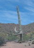
It was a steady incline going up Skunk Tank #247, and we noticed the tailings from Quien Sabe Mine on the south side of the trail. There was a large, upside-down steel basin in the drainage below Quien Sabe Spring...looks like that's been there for at least a few years [ photo ] , but it's now in the drainage and not on the trail anymore.

We turned onto Quien Sabe #250 and left the trail ~ four miles in. It was relatively tame off-trail hiking...a little rocky, but the brush is mostly of the non-sharp variety. The first half mile of off-trail was steeper as we made our way along the west side of the ridge before getting up on top, where it flattened out. The final stretch approaching the peak was very similar to hiking across Skull Mesa--flat ground, dry grass, and prickly pear mixed in with the rocks.

The views from the peak were very nice...the Superstition ridgeline and Weaver's Needle, Four Peaks, Skull Mesa, and downtown Phoenix visible to the SW through the haze. The summit register jar had two notebooks inside...looking back at comments on old triplogs, the now rodent-chewed notebook that @KingSnake placed a few years ago was one of them [ photoset ] [ image ] :). There was a second, newer notebook, and both had quite a few familiar HAZ names, with the most recent signature from almost a year ago, in February 2021. It sounds like the register and a summit cairn used to be located on the slightly lower peak just east of Quien Sabe, but the register is now on the actual peak, and there's no cairn on the other one.

[ youtube video ]

We ate lunch at the top and started back down. Instead of following the same route, we ended up descending straight down the steep hillside off the ridge to intercept Quien Sabe Trail a little earlier and avoid some of the off-trail. By late morning/early afternoon, the weather had warmed up and become very pleasant, and aside from those two hikers earlier in the day, we didn't see anyone again until we were within a quarter mile of the trailhead. After finishing up the hike, we stopped at Sears-Kay Ruins on the drive back--a nice bonus to finish the day.
 Culture
 Culture [ checklist ]
[ checklist ]  Summit Register Log
 Meteorology
 Meteorology [ checklist ]
[ checklist ]  Moon

dry Bronco Creek Dry Dry
water report recorded in the field on our app Route Scout

water 1 out of 5water 2 out of 5water less than maxwater less than max Seven Springs Wash Light flow Light flow
water report recorded in the field on our app Route Scout
 
193403
average hiking speed 2.18 mph
1, 2, 3, 4, 5 ... 7  Next

WARNING! Hiking and outdoor related sports can be dangerous. Be responsible and prepare for the trip. Study the area you are entering and plan accordingly. Dress for the current and unexpected weather changes. Take plenty of water. Never go alone. Make an itinerary with your plan(s), route(s), destination(s) and expected return time. Give your itinerary to trusted family and/or friends.

helpcommentissue

end of page marker