|
| | | |
| |
|
| Hiking | 13.04 Miles |
835 AEG |
| | Hiking | 13.04 Miles | 6 Hrs 30 Mns | | 2.01 mph |
| 835 ft AEG | | | | |
|
|
| |
| Linked |
|
none
[ show ]
| no linked trail guides |
| Partners |
|
none
[ show ]
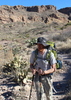
| no partners | | It's funny how different hikes can bring out different feelings. Last week I drove up to Prescott and jogged Willow Trail. After completing the run I felt charged, almost euphoric. Imagine a puppy dog with his tail wagging looking for his next treat. Today, after finishing Willow Springs via FW (mileage similar to last week's run) the sentiment was thank goodness  ...I made it. Now, where's the nearest QT, because I need to refuel. ...I made it. Now, where's the nearest QT, because I need to refuel.
When doing hikes that I'm not overly familiar with I'll try to plan appropriately. For this hike, I downloaded the route onto my Garmin, printed out Fritski's trail description even made sure I had my clippers in my car in case I needed to do any trimming of bushes. I got about 2 miles from the house and realized I didn't have everything I needed. I wanted to be prepared so I went back. Got to the FW Trailhead around 5:30. A little later than I wanted but not too bad. I beat the rush, as I was the first car there. Signed the trail register and noticed that Fritz had been out there on 8/2. I guess I got preoccupied wondering if that Fritz was my inspiration for the hike. I was .3 miles into my hike when I realized that my clippers never made it into my backpack...they were still sitting on the front seat of my car. ](https://hikearizona.com/dex2/images/smilies/eusa_wall.gif "Brick wall") Decision time. Continue on or go back. I've bushwhacked before without clippers; they're more of a luxury. So, "onward the Light Brigrade". I was about .9 miles down the trail (on the Dutchman by then) when I realized that I had left Fritzski's trail description at the trail register . Sometimes I really amaze myself. And this is me trying to be prepared Decision time. Continue on or go back. I've bushwhacked before without clippers; they're more of a luxury. So, "onward the Light Brigrade". I was about .9 miles down the trail (on the Dutchman by then) when I realized that I had left Fritzski's trail description at the trail register . Sometimes I really amaze myself. And this is me trying to be prepared  . Decision time. Continue on or go back. I had my Garmin with the downloaded route and a backpack with water, so "was there a man dismayed, not though the soldier knew". . Decision time. Continue on or go back. I had my Garmin with the downloaded route and a backpack with water, so "was there a man dismayed, not though the soldier knew".
Despite my incompetence when it comes to preparation for hikes once I get out there I tend to do all right. I had the track manger open most of the time early on because I wasn't sure where Parker's Pass was and the consequential turn off from the Dutchman, so my distances are rough approximations. From the FW Trailhead I'd say I was about 2.9 miles in when I came to Parker's Pass and the turn off. Initially, I didn't see the side trail and I did some legitimate bushwacking as I tried to "connect to that blue line on my Garmin." However, once I found the side trail, it really wasn't too bad. I followed it easily enough to O'Grady's Canyon. I did lose it briefly in the creek bed prior to climbing the slope to Tim's Saddle, but once I got back on I was able to get to West Boulder Canyon (WBC) without incident. This side trail was overgrown badly in several places, but I didn't feel that the Cat'c Claw or prickly pear was that bad. It was more Jojoba and other non-prickly vegetation. The spider webs were annoying though. Rough estimate: I would say it was about 1 mile from the Dutchman to WBC.
Once I got to WBC, the "trail" opened up quite a bit. There really wasn't a trail from this point on (I didn't see very many cairns to be honest...but there was a good-sized one where the trail from Tim's Saddle connects to the WBC), but the canyon was fairly expansive enough that I was able to navigate the terrain fairly "easily" without getting my feet wet or having to climb canyon walls. Yep, I said get my feet wet.  I followed WBC for almost 2.75 miles (this is based off my rough estimates of getting to WBC) and for 2 miles of it there was flowing water. Most of the time the water wasn't that deep so I was able to rock hop along the side of the stream. As I was doing this part of the hike it would have been nice to have had Fritzski's trail description and pictures. As I was hiking I kept trying to identify Fritzski's "notables". I didn't have a problem with the house sized boulder. That one I got. (Very cool area, by the way). But I couldn't for the life of me, pick out Willow Springs. I came across three places where cattails or even marsh reeds were growing. The spot where the marsh reeds were, looked the most like the picture, but I don't think there was a willow tree there. After the hike, but before doing this triplog, I read a previous write up and hikerdw from 2013 said the cattails/marsh reeds had been washed away by a monsoon storm. So it may be that the tree stands alone and I went right by it without even realizing it. Speaking of going right by... I went right by the Rudolph's rock corral. I was following the little blue line on my Garmin and it took me about .5 miles past the peninsula and the corral. The reason I know this, is because on the return trip I was very lucky to catch a glimpse of the corral. Talk about overgrown! I could just barely make out what I think was the described corral in Fritzski's trail description. It was just on the south side near the tip of the peninsula. I never saw the wire corral, though I did come across a bench with a "sticked" cairn that makes me think that might have been the place. On the way out, I retraced my steps. I was curious to see where I had lost the user trail at O'Gradys Creek and at the Dutchman juncture. I followed WBC for almost 2.75 miles (this is based off my rough estimates of getting to WBC) and for 2 miles of it there was flowing water. Most of the time the water wasn't that deep so I was able to rock hop along the side of the stream. As I was doing this part of the hike it would have been nice to have had Fritzski's trail description and pictures. As I was hiking I kept trying to identify Fritzski's "notables". I didn't have a problem with the house sized boulder. That one I got. (Very cool area, by the way). But I couldn't for the life of me, pick out Willow Springs. I came across three places where cattails or even marsh reeds were growing. The spot where the marsh reeds were, looked the most like the picture, but I don't think there was a willow tree there. After the hike, but before doing this triplog, I read a previous write up and hikerdw from 2013 said the cattails/marsh reeds had been washed away by a monsoon storm. So it may be that the tree stands alone and I went right by it without even realizing it. Speaking of going right by... I went right by the Rudolph's rock corral. I was following the little blue line on my Garmin and it took me about .5 miles past the peninsula and the corral. The reason I know this, is because on the return trip I was very lucky to catch a glimpse of the corral. Talk about overgrown! I could just barely make out what I think was the described corral in Fritzski's trail description. It was just on the south side near the tip of the peninsula. I never saw the wire corral, though I did come across a bench with a "sticked" cairn that makes me think that might have been the place. On the way out, I retraced my steps. I was curious to see where I had lost the user trail at O'Gradys Creek and at the Dutchman juncture.
This was a rough hike. Not so much because of the distance, but because of the nature of the trails. The Durchman and even the connector trails weren't that bad. But I think rocky nature of the WBC really took its toll. There was a lot of up and down and stretching and contorting that you don't typically do on most hikes. Plus, I must admit that I did end up walking a couple of miles in wet shoes. As unintentional as it was, the water did feel very nice and my shoes and socks did dry out fairly quickly. The other factor that made this a rough hike were the temps and humidity and very little wind. The air was stiffiling. . Due to my departure time, I had nice temps and shade for the first 5 miles but after that it was sun exposed the whole time. Wildlife included a horny toad, deer, a couple of snakes (one of which slithered away in inch deep water flowing down the WBC) a dozen lizards, a handful of frogs and hundreds of tadpoles. I didn't see any hikers while I was out and when I got back to the TH I was still the only car there. On the Dutchman, I did find a very nice hat (it was not a Steelers hat though), so if anyone knows of someone who lost a hat on the Dutchman please let me know. It is in nice shape, probably left on the trail for less than day. |
| _____________________
| | |
|
|
|
 Route Editor


 Plenty of water in many spots on the way in as well as lots flowing over the rocks from the pool formed at the spring. on the way back crossed Tim's saddle (completely off trail, couldn't find one) because I figured it had a name due to being a route of travel. I did find the trail on the Saddle and took it down to O Grady Creek, but I followed the creek thru the canyon because (once again) lost the trail. What a cool canyon! Little pools and waterfalls. Next trip I think I would try to climb the saddle near Wilow Spring and catch the view of the Needle from there. What a fun, if meandering and trailess, hike!!
 while
while  but that's my

