|
| | | |
| |
|
| Hiking | 16.20 Miles |
3,346 AEG |
| | Hiking | 16.20 Miles | 9 Hrs 14 Mns | | 2.36 mph |
| 3,346 ft AEG | 2 Hrs 22 Mns Break | 10 LBS Pack | | |
|
|
| |
| Partners |
|
none
[ show ]
| no partners | | Presidents' Day 2021, I had had my second Covid shot just a couple days before. I thought I would take something a little less adventurous than my usual lonely wilderness trip; do something with people around just in case, you know. 
I started at 7 am at the Area 9 trailhead for the Ford trail, and headed out, capturing a few nice pictures before the light got lousy. There are several Geocaches along this section as well, which was an additional incentive for doing this trip. I was amused by the map at the trailhead suggesting the section of Ford Canyon in the wash might be a little rugged, and the additional signs along the trail telling horses and bikers effectively, "I'd turn back if I were you."
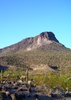
The canyon was beautiful. Truly shows how the White Tanks got their name. I had to stop at every pond and take a few pictures. You only get one in my photoset, though. I leapfrogged up the canyon with a couple of women about my age. I would stop for a picture or a Geocache, and they would go by. They would stop for a short break and I would go by. Finally lost them at the last couple Caches.
At the first pass at the top, after leaving the canyon, there is a nice rock just off to the left of the trail overlooking the valley and peaks, and a good place to refresh. From there, I could here voices carrying more than 1000 yards away from the Waddell and Mesquite trails (remember this, you noisy chatterers). Then down 250 feet and back up to the end of the Ford Canyon Trail at its intersection with the ends of the Mesquite Trail and Goat Canyon Trails.
I turned right on Goat Canyon, and headed toward Barry Goldwater Peak. Eventually, a couple of cairns mark the departure of the way trail to the peak from the Goat Canyon trail. The official log calls this a jeep trail. Not any more. It is a faint singletrack. I put waypoints in my track for some of the cairns along it. You will see in my track I diverged from it for a bit; it is easy to do. Maybe the waypoints will help you stay on task. The cholla is a constant threat in this section.
Eventually you hit the road to the summit. I have to say the summit is a little disappointing. Yes, from different vantage points, you can see forever in all directions. In fact, so forever the major peaks seem tiny. But the towers, the wires, and the noise from the A/C units, detract from the victory somewhat. I had my lunch on the pad of one of the towers. Forgot to look for the summit register.
I returned to my car via the Mesquite trail and Waddell trail. The farther down I got, the more people I saw. Probably altogether saw 45 people on the Mesquite Trail. The lower I got, the more they were huffing and puffing. I was astounded by the fences put up to protect the trail from people cutting switchbacks. I have never seen this before. It shows just how ill behaved some people are who hike this trail.
I'll give this trip 4 stars. Five stars for Ford Canyon and two stars for Mesquite Trail and the summit. |
|
Wildflowers Observation None
There is evidence of recent rain. The Ocatillo are just starting to green up. There is quite a bit of green grass. The flowers should be out soon. |
|
| | |
|
|
|
 Route Editor


 Now I need to do Quartz.


 up the hill (he called it "life coaching") whereupon we took a delightful break under a warm sun. The previous few miles had been uphill against a bone chilling wind that was doing its best to beat us back down. The break at the top under sunny skies with a wind break at our backs was simply wonderful.