|
| | | |
| |
|
| Hiking | 42.56 Miles |
7,000 AEG |
| | Hiking | 42.56 Miles | 3 Days 8 Hrs 56 Mns | | |
| 7,000 ft AEG | | | | |
|
|
| |
| Partners |
|
none
[ show ]
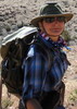
| no partners | | Four days unplugged and off the grid with my high school senior daughter--the caboose of our family--was just what the dr. ordered. Originally, we had planned to bring a few more family members, but jobs, school, and other commitments reduced this to a daddy-daughter trip, and it was one for the books.
Day 0: Travel up and Camp at Triple Alcoves TH
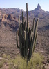
Thursday, we strolled out of town mid-morning, took lunch in Flag, and made a pit stop at Navajo Bridge. We knew it was a good omen when we saw two California Condors swoop in for a roost underneath the vehicle bridge. Then, taking advantage of our last official bathroom option, we headed down the Vermillion Cliffs to the Buffalo Ranch Road turnoff and 27-mile dirt road drive out to the eastern TH for the Nankoweap No. 57 trail. The road in was in pretty good shape--a little washboardy here and there, and one short, sandy spot in a wash crossing, but do-able in a sedan if you take it slow.
We arrived at the TH around 4:30 pm to find a surprising number of cars (10). Our plan was to spend the night near the TH to get an early start the next morning. The TH is in the middle of a burn area--not too scenic--and although certainly possible to camp there (or very close), it wasn't much on ambiance. Instead, we had scoped out a spot another 5 minutes drive beyond the NK 57 Trailhead, at the Triple Alcoves TH where we planned to set up camp for the night. Turned out to be a great choice. Triple Alcoves is just beyond the burn area, and there is a great little camp spot, complete with fire ring, directly across from the TH on a spur road. And, the main attraction for the evening, was that the TH provided a short 1/2 mile trail out to the edge of the rim with fantastic views of the Canyon, a nice stretch of the Colorado River and an excellent backdrop for the setting sun. We partook in just that adventure and enjoyed a beautiful, golden, sunset painted canyon as a primer for our backkpacking adventure the next morning. My separate triplog and photos for that short hike are here [ photoset ] .
Day 1: Hike to Our Basecamp on Nankoweap Creek
Friday morning, we were up before dawn, packed up camp, ate breakfast and backtracked the 5 minute drive back to the NK 57 trailhead. Arrived and got underway just as dawn was breaking on the horizon. Within the first half mile, we had our first incident. One of my daughter's hiking poles broke.  For those who've done this trail, you know having good hiking poles is definitely a plus--if not near mandatory. Oh well! I gave her one of mine and figured we'd survive! And it worked out fine. For those who've done this trail, you know having good hiking poles is definitely a plus--if not near mandatory. Oh well! I gave her one of mine and figured we'd survive! And it worked out fine.
From the TH at 6400 ft. the trail immediately rises 300 feet only to promptly give that 300 feet right back, as the trail drops steeply into the main drainage into Saddle Canyon. From there, I made a somewhat costly navigational error. Directly across from where the trail drops into the drainage is a trail that begins going up on the opposite side. Figuring that this was our trail, I began plugging up the trail, which climbs quite steeply. After a couple tenths of a mile and a couple hundred feet of AEG, I checked my GPS and realized that this was the trail to Saddle Mountain Summit, and that the NK 57 trail actually follows the creekbed in the drainage for awhile. So, we backtracked down our unnecessary additional AEG and got back on track. Gratefully, that was the last of our navigational errors for the trip.
However, I mentally underestimated the challenge of the ensuing ascent to the Nankoweap TH at the GCNP boundary. In that three-mile stretch, we gained over 1500 ft of elevation. With full packs, plus additional water for caching, it definitely got the heart and lungs pumping well before the Canyon ever came into view.
At last, we crested the saddle and within a few minutes arrived at the official TH. Others opt to knock out that initial 3 mi. ascent the evening before and camp at the official TH. Not a bad strategy, and there were several spots for decent camping.
We cached 2L of water near the TH, enjoyed our first views into the Canyon--which was a bit hazy, and then took the plunge below the rim.
After about 0.1 mi., the trail drops steeply down a break, giving you your first taste of the primitive trail. Then, it's on to the Supai traverse, with its seemingly endless undulations. Between the drop in and Marion Point, we began to pass a handful of groups coming out of the canyon. We chatted briefly with each, and they all shared that the past several days had been brutally hot. One group had decided to cut their trip a day short due to the heat. Another had made it to Mystic Falls on a day hike, and we were anxious for news (the Backcountry Office had no intel--in fact, the ranger told me she didn't know what Mystic Falls was??). They reported that the Falls were running, but that it was an absolute grind to get there. And the evidence of that grind was apparent on their heavily scratched up legs and arms.
We passed a couple more groups ascending from the Canyon before Tilted Mesa, and as it turns out, these groups constituted all of the 10 cars at the TH. So, we were in for some solitude! 
We stashed another 2 L of water at Marion Point camping area. BTW, there is a small flat camping area there, but not ideal, IMO. There is some shade, but not well placed or particularly comfortable. We took lunch there, but then realized that a better lunch spot lies another 100 yards or so beyond MP where the trail passes under a nice shaded overhang with plenty of flat rocks to stretch out on for a bit and enjoy the view.
As for exposure, we passed the old, storied sketchy spots (one before, and one after, MP) that I had seen in many photos and videos, but agreed that they were not all that sketchy for anyone with a reasonable tolerance for heights. The primary caution on the one past MP is to be "backpack aware," as there are a couple of rock outcroppings that need to be maneuvered around. All in all though, nothing to induce undue fear.
Eventually, we arrived at Tilted Mesa and the "Gates of Hell," which is promptly followed by the two downclimbs referenced in the hiking description. We took a longish break there in the shade and gave the feet a breather before starting our descent in earnest. Several good camping spots in this area, though I think the best were a little further down, including one spot for a small tent under a cedar tree where rocks had been built up to create a wind shelter. We cached our final 2L of extra water here, and were glad to have finally lightened our water load.
From Tilted Mesa, we finally started dropping elevation in earnest. That said, there is a fair amount of contouring even in this section, interspersed with several very loose and steep drops. Honestly, from an exposure standpoint, I felt that some of the spots in this area were more concerning than anything on the Supai traverse. But still, nothing to cause undue concern. In fact, we managed to make the entire trip up and down without taking a single fall. 
From Tilted Mesa, you can see Nankoweap Creek below, but it seems very far away and even after hiking and descending for some time, it didn't seem to be getting any closer, and we still seemed to have a lot of elevation to lose. Eventually, with about 1000 ft of drop in each of the three miles from Tilted Mesa, we pulled into Nankoweap Creek just before 4 pm, and were comforted to be near water again.
The area was deserted, and we were pleased to get what I consider the prime camping spot another 100 yards from where the trail meets the creek on the south side of the creek, up next to the south edge of the canyon. Lots of cottonwoods for shade (and my daughter's hammock), plenty of flat spots for tents, and a lot of good flat rocks for makeshift chairs, cooking, etc. This would be our home base for the next three nights.
Day 2: Granaries and exploring on the Colorado
After a relaxing evening in camp, we headed out the next morning for the presumptive highlight of the trip--a hike down to the river to explore the Granaries and the iconic views of the Canyon from that vantage point, as well as an exploration of the beaches and surrounding rapids along the river.
The trail-less travel down the creek was shaded in the morning, and other than the constant navigating of the rocky creekbed (a constant challenge for any exploring in this area), the hike down was pleasant. We passed a couple who had hiked in Buck Farm Canyon and packrafted 11 miles down river and were hiking out via Nankoweap. Cool idea, though I didn't envy their exit in mid day with no water cache on the way out.
We arrived at the granaries mid morning and I was worried that they would be taking the direct sun at that time, but was surprised and pleased to find that they had already taken all the direct sun they would get and were already in the shade. Also, while we saw a few rafts down at the rafters' beach, no one was at the granaries. So, we ascended and had the place to ourselves for a couple of hours.
And bonus, as we were making our final ascent to the granaries, another California Condor was gracefully weaving back and forth above us on the morning updrafts. Beautiful. As were the views from the granaries. With the river flowing clear and green, we could not have asked for a better backdrop, and we spent a couple of hours just relaxing, exploring, and taking it all in.
Eventually, several other rafting parties arrived and made their way up to the granaries. We had had our fill by that point, and made our way down to explore the beaches. Slightly further down river from the rafters' beach is another very nice beach that would be my destination as a backpacker if I intended to camp overnight. It's less popular with the rafters because it is slightly smaller and further away from the granaries, but it is an excellent beach with excellent camping options right on the river, with amazing views. My daughter and I hung out there and relaxed for another hour or so, playing in the water and beach.
After the beach, we wandered down river a way to some rapids and watched as several of the rafting parties ran the rapids in the afternoon.
Then, we explored back upstream and the other, larger (but unshaded) beach area north of the rafters' beach, before finally turning back towards our camp. On the way back to camp, we came across a group of 5 deer (3 adults and 2 fawns). They allowed us to get quite close before scurrying away. Looked like it had been a tough year for nourishment ...
Back at camp just before the sun dropped behind the canyon walls. That evening another couple arrived in the area and set up camp. But they were gone by 4:30 a.m. the next morning.
Day 3: Almost Mystic Falls
On day 3, we decided to make an attempt on Mystic Falls. Hoping that the group we had talked to made some poor navigational choices that led to their intense bushwhacking, we set off in the early morning. The creekbeds for the first three miles were pretty passable, with some brush and bushwhacking but not bad. However, beyond the junction where the route turns left between Seiber and Bourke Points, the creek becomes an absolute nightmare of choked trees and brush. As it turns out, the shelfs above the creek aren't any better. With only about a mile to go to the falls--but probably a 3-4 hour commitment to heavy bushwhacking, we made the decision to abandon the attempt, knowing that tomorrow morning we would be making the long climb out of the Canyon. It was slightly disappointing, but it was the right call for us on this trip and avoided making the return trip a real death march. As a consolation, we came across two stout bucks on the way back with good-sized racks, and told ourselves that this was worth the trip :-)
With the change in plans, we arrived back at camp in mid afternoon and had something I wasn't used to on a backpacking trip--several hours of relaxing down time! It was great to take a nap in my daughter's hammock--and I decided I need to get me one of those, as I slept much better than in my tent/pad.
The evening came with lots of good father-teenager conversation, and we hit the hay early, with a plan to get up at 4:30 to ready for the hike out. Once again, we had the camping area to ourselves.
Day 4: The Hike Out
We awoke dark and early. The temperatures generally had moderated from the week before, and the last night, while still pleasant, made me grateful I had opted to bring the sleeping bag, rather than just a liner.
Camp clean up, etc. took a bit longer than expected, but we were on the trail by 6 a.m. with the goal to be on Tilted Mesa before we got too much direct sunlight.
Those first three miles and 3K AEG are a challenge, but honestly, easier to go up than down, IMO. About half way up, we ran into a couple of hikers who had spend the night on the mesa and were descending to do a day hike to the granaries and back. We shared some thoughts and wished them luck.
We made the Mesa in decent time and retrieved our first water cache. After a short break, we continued on towards Marion Point, and took lunch in the overhang spot we had located on the way in. Passed another couple of hikers planning to spend a week in the canyon and then a solo hiker with a similar agenda who confirmed that it was only his car and ours at the eastern TH.
We were elated to get back to the official GCNP TH around 1:30 pm, and after taking at 20-30 min break realized that it was actually going to take us less time to hike out of the canyon than it did to hike in!
The decent from the saddle made me even more impressed with our initial climb on the first day. That final 300 ft climb out of the drainage with less than 1.4 mi to go was just sick and wrong! But we conquered it, retrieved our broken hiking pole from the side of the trail, and celebrated victory at the car shortly thereafter.
My daughter got some good dirt-road driving experience on the drive out.
We hit the showers at Marble Canyon Lodge ($2.50 in quarters), then headed to Flagstaff where we telephoned in a order for some pizza from NiMarco's in advance. It was hot and delicious when we arrived.
The drive home had one more twist for us, as we managed to get a flat tire just before the big climb out of Camp Verde. So, we got to have some lessons on tire changing as well.
Arrived home about 12:30 a.m., exhausted but feeling accomplished and with a backpack full of lifelong memories with my daughter, which I will forever cherish! |
| _____________________
| | |
|
|
|
 Route Editor


 , and the awesomeness of being in a place built a long time ago. I could have stayed here all day but there was beer to drink and a river to swim in.
 but once I reached that point, I knew I would see my kids again.

