username
X
password
register
for free!
help
ArticlesGuidesRoutes
 
Photosets
 
 Comments
triplogs   photosets   labels comments more
Santa Rita Mountains - AZT #5 - 19 members in 69 triplogs have rated this an average 3.4 ( 1 to 5 best )
1, 2, 3, 4  Next
69 triplogs
login for filter options
Apr 11 2025
avatar

 Guides 1
 Routes 14
 Photos 7,202
 Triplogs 5,208

68 male
 Joined Mar 16 2008
 chandler,az
Santa Rita Mountains - AZT #5Tucson, AZ
Tucson, AZ
Hiking avatar Apr 11 2025
johnlpTriplogs 5,208
Hiking13.31 Miles 1,657 AEG
Hiking13.31 Miles   4 Hrs   5 Mns   3.31 mph
1,657 ft AEG      4 Mns Break
 no routes
Linked   none no linked trail guides
Partners partners
trekkin_gecko
Road trip to the south to visit my daughter and get in some good hiking. Kelly had not completed segment #5 of the AZT, so to assist I dropped her off at the south end of the segment while I drove to the north end and then hiked in until we met. Then we hiked together back out to the car. We got started fairly early and got done before the warm weather settled in.
Fun to get back out on the AZT! :)
wildflower observationwildflower observationwildflower observationwildflower observationwildflower observation
Wildflowers Observation Isolated
_____________________
“Good people drink good beer.” Hunter S Thompson
 
Apr 11 2025
avatar

 Guides 10
 Routes 673
 Photos 7,281
 Triplogs 4,660

67 female
 Joined Nov 17 2008
 phoenix, az
Santa Rita Mountains - AZT #5Tucson, AZ
Tucson, AZ
Hiking avatar Apr 11 2025
trekkin_geckoTriplogs 4,660
Hiking14.89 Miles 1,892 AEG
Hiking14.89 Miles   4 Hrs   30 Mns   3.36 mph
1,892 ft AEG      4 Mns Break
 
1st trip
Linked   none no linked trail guides
Partners partners
johnlp
Route Scout Route Recorded  on Route Scout | Pop | Map | Popup | MapDEX
john arranged for us to spend a couple nights in vail
he also agreed to drop me off the start of passage 5 at gardner canyon road, then hike in to meet me from the north end
i got started around 0615
cool temps to start with
rolling grassland hills with a nice view of mount wrightson
half the hike on single track, half on double track or forest service roads
met up with john at just over eight miles in
finished up around 1045 as temps were warming up
didn't see anyone the entire hike, except for the two people staying at the b & b at kentucky camp
very pleasant segment
happy to get this one done
still need passages 1 and 9 to fill in some gaps in southern arizona
thanks for the assist, john, much appreciated!
 Culture
 Culture [ checklist ]
[ checklist ]  Pioneer Industry
_____________________
hazhole
  1 archive
Dec 06 2024
avatar

 Guides 187
 Routes 989
 Photos 12,068
 Triplogs 864

72 male
 Joined Jun 27 2015
 Tucson, Arizona
Kentucky Camp, AZ 
Kentucky Camp, AZ
 
Hiking avatar Dec 06 2024
markthurman53Triplogs 864
Hiking5.20 Miles 730 AEG
Hiking5.20 Miles   2 Hrs   29 Mns   2.14 mph
730 ft AEG      3 Mns Break20 LBS Pack
 
Linked   linked  
Partners partners
mamakatt22
Short hike from Greaterville, Morning Star Mine to Kentucky Camp. My Grandson wanted to go on another hike and I thought this might be a good one especially since he has an interest in old mines. Started out at the Morning Star Mine where we spent a little time exploring the area. The mines have been gated off and the old wood shack that use to stand over the mine is no longer there.

The trail to Kentucky camp (AZT #5) follows a dirt road, FR163. Steep climb from the Morning Star mine for the first .75 miles then downhill the rest of the way. There were a couple of through AZT hikers at Kentucky camp, no one else. It is deer season so there were hunters along the road in. Great day for hiking with cool temps but not cold.
_____________________
 
Mar 20 2024
avatar

 Photos 18
 Triplogs 3

male
 Joined Jan 08 2023
 
Santa Rita Loop, AZ 
Santa Rita Loop, AZ
 
Backpack avatar Mar 20 2024
Layne32Triplogs 3
Backpack30.00 Miles
Backpack30.00 Miles4 Days         
 no routes
1st trip
I got a lot of great help from user Jim_H to make my first visits to the Santa Ritas (this is my first triplog here, not sure if we can tag other users). I did 2 backpacks in a week there after bailing on my first trip due to getting caught in "severe gale force" winds and driving snow (Mar 14-15) at Baldy Saddle. My tent got blown down and I had to cowboy camp in 50+ mph sustained winds & sub-freezing temps. This report is mostly from my second trip.

AZT / Ditch Mountain
Be warned: the only commercially available map for the Santa Ritas (Green Trail Maps) shows the wrong location of the AZT, as does CalTopo. That caused problems for me on my first trip. Second trip I followed the old AZT routing starting from Apache Springs TH - down the Forest Road to Ditch Mountain Trail. Camped near Bear Spring.

Walker Basin / Gardner Canyon
Good climbs on these trails to go from the foothills of the Santa Ritas to the Crest. I didn't start to see snow on the trail until the upper reaches of Gardner Cyn Tr (~8000'). Looking around at north-facing slopes showed the snow level starting ~6500'.

Super Trail
The stretch of Super Tr from Gardner Cyn to Baldy Saddle was mostly snow covered. Fortunately the snow was still cold and hard-packed (Mar 21) so I was not post-holing. Another good climb, ~500' over a half mile. I didn't attempt Wrightson, it was completely snow covered, but some day hikers were doing it. Camped on a little exposed knoll above Baldy Saddle with great views - the same spot I got stormed out of a few days before.

Crest
Most of the Crest Tr was snow covered but it was entirely passable. I carried traction devices but didn't need them the whole trip. Snow was still cold and hard-packed (Mar 22) so I was not post-holing. As with all Sky Island crests - incredible views with many mountain ranges in the distance (Huachucas, Whetstones, Patagonias, Rincons, Catalinas, etc.)

East Sawmill Canyon
After Crest this was my second favorite Trail of the hike. Starts off a little confusingly by continuing to rise along the Santa Rita crest before dropping into East Sawmill Cyn. Beautiful forests up top, tight canyon in the middle, desert scrubland at the end.

Greaterville
My map showed the beginning and end points of this trail as about the same elevation so I thought it was going to be a mostly flat walk. Nope. Goes straight up a ridge then straight back down the other side. Greaterville Tr links to FR 165 which I took until connecting back with the AZT.

AZT
Road walk for a bit to Kentucky Camp where I stayed the night. Better camping back along the AZT than here at KY but there was water at KY. Finished up the trip along the AZT back to Apache Springs TH.


All in all the Santa Ritas were a great place to backpack. Trail system very nice and no problems navigating. Water was flowing everywhere except Baldy Spring which was covered in snow. Thanks again to Jim_H.
 
Mar 16 2024
avatar

 Routes 93
 Photos 7,758
 Triplogs 1,691

64 male
 Joined Mar 11 2003
 AZ
Santa Rita Mountains - AZT #5Tucson, AZ
Tucson, AZ
Hiking avatar Mar 16 2024
wallyfrackTriplogs 1,691
Hiking14.99 Miles 2,026 AEG
Hiking14.99 Miles   6 Hrs   21 Mns   2.50 mph
2,026 ft AEG      21 Mns Break
 no routes
1st trip
Linked   none no linked trail guides
Partners partners
DarthStiller
Andy and Ray both had injuries so they were out. I couldn't think of an excuse fast enough so I hiked. The drive down 587 (& parts of I10) was a bit foggy. I added a few miles by making a right turn at the stop sign when I should've went straight. Once I realized I was on the I10 ramp going the wrong way and not going to the bridge over the I10 it was too late. At least I'll remember the next time I can't see 20 feet ahead to think before proceeding. Chris was waiting for me at the Craycroft exit, probably a few seconds away from putting out a silver alert when I got there. After that things went ok.

The recent rain kept the dust down. We started about 8:20 am so the temperatureit was already in the 40s and not the low 30s. There was more cloud cover than expected and a breeze so it remained cool for most of the day. We saw some through hikers, day hikers and a lot of side by sides and cows. The trail was in good shape and the view of Mt Wrightson kept changing with the clouds and different angles. There were interesting stops along the way with the mines, camps and equipment.

It was a good day to be out on the trail. Both trailheads were busy and we got out just ahead of a horse/mule trailer which probably saved 20 minutes. Words, words, words,words, words words. Just a few extra words to make this count as a triplog.
_____________________
  4 archives
Mar 16 2024
avatar

 Guides 27
 Routes 669
 Photos 12,096
 Triplogs 856

56 male
 Joined Jul 05 2006
 Mesa, AZ
Santa Rita Mountains - AZT #5Tucson, AZ
Tucson, AZ
Hiking avatar Mar 16 2024
DarthStillerTriplogs 856
Hiking14.99 Miles 2,026 AEG
Hiking14.99 Miles   6 Hrs   21 Mns   2.50 mph
2,026 ft AEG      21 Mns Break
 
1st trip
Linked   none no linked trail guides
Partners partners
wallyfrack
Ray was a late scratch for this one due to a lingering leg injury, so Wally and I did this entire section as another shuttle hike. Lots of fog early on in the predawn drive to I-10 across part of the res. Wally made the wrong turn to get on I-10 and was headed the wrong way to the next to turn around. We agreed to me at the usual exit before the final leg down SR83 and I was waiting 20 minutes wondering if he had an accident before he showed up.

We drove down to the Apache Springs TH first and dropped off his vehicle. The lot had quite a few people there already and a trail maintenance/building crew was also there looking like they were ready to head out. We drove back up to the Oak Tree Canyon TH and hiked southbound back to Apache Springs.

Weather was mostly sunny all day, but with patchy clouds that would frequently cover the sun and provide cool temperatures. Mt. Wrightson was prominent again throughout this hike, and got more so as we hiked closer to it. Most of the morning the top was covered by clouds. There was fresh snow on it from the rain the night before. A few of the thru hikers we was hiking NOBO mentioned the rain the night before and they seemed much happier to be in sunnier and warmer weather. One thru hiker was in from Pittsburgh hiking the trail. I gave her the latest updates on the big week the Steelers had in free agency, only to get back later and find out even more had happened.

We stopped for lunch just below the Morning Star mine. After lunch, I noticed the road going up over there and we went and checked that out. Turns out right by the mine entrances would have been a much better place to have lunch rather than on the road as the ATVs rumbled by. The entrances to the mine are closed off, but you can get some interesting glimpses into it. Very interesting area.

Before we did this hike, I downloaded the history fact sheet from the AZT website for this passage and I’m glad I did. It gave information about the placer gold mining that took place in this area and the settlements that arose briefly to support that. It make it cooler to see things while we were hiking and have a better idea of what we were looking at. Kentucky Camp was another good example of this, although they do have several interpretive placards there and along the trail to tell what some things area. Also, I just discovered that these history sheets on the AZT site are written by @PrestonSands. Thank you, Preston.

Just south of Kentucky Camp we saw a father and son who were panning for gold in the gulch. The father told us he found a gold flake. When the trail crossed the gulch a little later, Wally kicked a few rocks looking for gold, but only found some pottery sherds, arrowheads, a grinding stone, etc. :whistle: This area also had a lot of mounds and depressions that were from a mining technique that invented the term “pay dirt”, which was interesting.

The water line at the south end of this passage coincides with the trail for a short segment as it was built on top the bedrock there. One area where it crosses a gulch the line was gone, but the leftover rocks and wood braces for the trestle for it were still there.

Got back to Apache Springs and made very good time. Scenery was nicer than the north end of AZT6, and the history and mining ruins also added some interest. :M2C:
_____________________
  2 archives
Dec 30 2023
avatar

 Guides 1
 Routes 1
 Triplogs 24

45 male
 Joined Feb 27 2012
 Cochise County
Greaterville Trail #79Tucson, AZ
Tucson, AZ
Run/Jog avatar Dec 30 2023
AndrewAZTriplogs 24
Run/Jog15.50 Miles 2,470 AEG
Run/Jog15.50 Miles
2,470 ft AEG
 no routesno photosets
1st trip
Partners none no partners
I parked at the Box Canyon TH and ran south on the AZT to join the Old Pueblo 50 course at Enzenberg Canyon. I ran up Enzenberg to Melendrez Pass, then up the Greaterville Trail over Jerry's Pass, down the trail to the junction with Sawmill, and then to Aliso Spring before turning around. I felt good when I hit Aliso Spring, but having to turn around and go back up the 2.5 miles to Jerry's Pass was a real :pk: kicker. I was out of gas for the remaining 5 miles from there back to Box Canyon TH.

I went up Enzenberg Canyon last January, and there was a lake at the tank that was big enough to block the 4x4 road along it. Zero water in the tank this year.

Part of the 4x4 road up Enzenberg shortly before Melendrez Pass is steep. Only a short stretch thankfully. The same is true of the first half-mile or so of the Greaterville Trail. It's so steep that even hiking it is a workout.

The views from Jerry's Pass (in both directions) are well worth it. Greaterville Trail was a bit overgrown with grass, but not thorny brush. Overall, much better trail than I expected all the way to Aliso.

I couldn't even believe the amount of water flowing down the canyon from Aliso Spring. One would never know this has been a dry year so far based on how much water was there. Nice campsites, too.

I saw one doe on the steep section of Greaterville Trail. I saw a trio of scouting hunters down the 4x4 road into Enzenberg Canyon from the Melendrez Pass side. I hope I'm now the "weird trail runner in the middle of nowhere" in a story.
_____________________
 
Nov 14 2023
avatar

 Guides 187
 Routes 989
 Photos 12,068
 Triplogs 864

72 male
 Joined Jun 27 2015
 Tucson, Arizona
AZ Trail Santa Rita Mountains, AZ 
AZ Trail Santa Rita Mountains, AZ
 
Hiking avatar Nov 14 2023
markthurman53Triplogs 864
Hiking9.18 Miles 1,205 AEG
Hiking9.18 Miles   4 Hrs   48 Mns   1.95 mph
1,205 ft AEG      6 Mns Break20 LBS Pack
 
1st trip
Partners partners
mamakatt22
Started from Helvetia road and headed south for 4.5 miles. The Arizona Trail from hope Camp to the north to this point along the Santa Ritas just keeps getting better with this hike being the most scenic. Love the juniper, oak, grassland surroundings. This section is also one of the more challenging (but not difficult) as it is a continuous uphill. Light overcast skies with wispy clouds made for a comfortable hike. We hiked to a point along the Arizona trail that we had hiked last year and returned the way we came.

The trail has seen some maintenance very recently and is in good condition. Only saw one other pair of hikers doing a two day along this stretch. Saw a couple of white tail deer in one of the canyons, they were doing their best to avoid the hunters as it is hunting season. The usual cattle along this section. No water along this trail
_____________________
 
Mar 31 2023
avatar

 Guides 1
 Routes 262
 Photos 864
 Triplogs 266

51 male
 Joined Mar 24 2021
 Tucson, AZ
Santa Rita Mountains - AZT #5Tucson, AZ
Tucson, AZ
Hiking avatar Mar 31 2023
JackluminousTriplogs 266
Hiking18.01 Miles 2,322 AEG
Hiking18.01 Miles   6 Hrs   41 Mns   3.04 mph
2,322 ft AEG      46 Mns Break
 
1st trip
Linked   none no linked trail guides
Partners none no partners
Route Scout Route Recorded  on Route Scout | Pop | Map | Popup | MapDEX
This was an unexpected journey.

I had set off to hike Mt Wrightson from Gardner Canyon. Unfortunately the Forest Service had other plans, as they were doing a prescribed burn along the road to the trailhead. I stopped to chat with some of the fire crew to see if the trailhead was open, and while technically it was, the road was choked with equipment and it was soon obvious that my original plan was not good for them or me. So I detoured to the closest accessible trailhead, which was the AZT.

I was pretty disappointed at first, as I had been looking forward to seeing snow and pine trees and enjoying a lung-busting incline. I had brought a puffy jacket and stove for a hot lunch and everything. Alas, I was confined to the lower elevations, and road-hiking no less.

Determined to cheer myself up, I decided to look on the bright side. If a murderous cow took me out on the road, it would be easier to recover the body. And I can hike faster on roads, so I don't have to spend as much time on them.

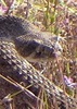
The scenery did a much better job at improving my spirits. I hiked nine miles without seeing a soul, and enjoyed the solitude. I saw lots of AZT hikers on the way back, all headed north, and that was fun, too. Everyone was enjoying their day, despite the fire going on. One hiker reported having gotten ash fall, like walking through snow. The AZT south of the Gardner Canyon trailhead was very close to the fire.

On the way back, the smoke from the fire was obscuring Wrightson and the Crest in a haze. As I returned to the trailhead, I got a great view of the flames and all the fire crews doing their work. The smoke had a faint vanilla odor to it.

Back at the car, I chugged a liter of coconut water while watching the fire for a bit, then headed home. Not the day I expected, but a good day nonetheless.
wildflower observationwildflower observationwildflower observationwildflower observationwildflower observation
Wildflowers Observation Isolated
A few here and there. This trail is probably not the best if you're into wildflowers.

water 1 out of 5water 2 out of 5water less than maxwater less than max FS 165 Stock Pond 26-50% full 26-50% full
Kinda green and slimy. Considering the proximity to Kentucky Camp and its tasty well water, it's tough to imagine getting water here.
 
Feb 17 2023
avatar

 Guides 59
 Routes 1,100
 Photos 1,191
 Triplogs 1,290

male
 Joined Jan 01 2023
 Arizona
Santa Rita Mountains - AZT #5Tucson, AZ
Tucson, AZ
Hiking avatar Feb 17 2023
pseudalpineTriplogs 1,290
Hiking14.81 Miles 1,872 AEG
Hiking14.81 Miles   6 Hrs   38 Mns   2.39 mph
1,872 ft AEG      26 Mns Break
 
1st trip
Linked   linked  
Partners none no partners
Route Scout Route Recorded  on Route Scout | Pop | Map | Popup | MapDEX
A nice day, well-spent 'living' with Rowdy & Widowmaker. Perhaps sometime soon we can tick off some of the other southern AZT passages. :-s
 Named place
 Named place [ checklist ]
[ checklist ]  Mount Wrightson
  4 archives
Jan 14 2023
avatar

 Guides 11
 Routes 123
 Photos 818
 Triplogs 257

62 male
 Joined Jul 14 2011
 Tucson, AZ
Santa Rita Mountains - AZT #5Tucson, AZ
Tucson, AZ
Hiking avatar Jan 14 2023
Mountain_RatTriplogs 257
Hiking15.68 Miles 1,952 AEG
Hiking15.68 Miles   5 Hrs   41 Mns   2.95 mph
1,952 ft AEG      22 Mns Break16 LBS Pack
 
no photosets
1st trip
Linked   linked  
Partners partners
miscbs

water 1 out of 5water 2 out of 5water 3 out of 5water 4 out of 5 Enzenberg Tributary Tank 76-100% full 76-100% full
Pretty full

water 1 out of 5water 2 out of 5water 3 out of 5water 4 out of 5 FS 165 Stock Pond 76-100% full 76-100% full
Mostly full & mostly green
_____________________
🥓🥓🥓
  1 archive
Apr 23 2022
avatar

 Guides 187
 Routes 989
 Photos 12,068
 Triplogs 864

72 male
 Joined Jun 27 2015
 Tucson, Arizona
AZ Trail #5 Box Canyon Rd, AZ 
AZ Trail #5 Box Canyon Rd, AZ
 
Hiking avatar Apr 23 2022
markthurman53Triplogs 864
Hiking7.90 Miles 1,128 AEG
Hiking7.90 Miles   3 Hrs   23 Mns   2.36 mph
1,128 ft AEG      2 Mns Break
 
1st trip
Linked   linked  
Partners partners
mamakatt22
Short hike today close to home to add a few more miles to our April stats. We hiked the Arizona Trail #5 from Box Canyon Road to Ophir Gulch. Pleasant walk through Oak grassland. The weather was perfect in the low 70's with a light breeze. Probably the last cool day for a while. This really is a pleasant hike along a good trail/road. This is the kind of hike you might take later in the day around sunset just to get out and enjoy the outdoors. The only water along the trail was in one of the cattle tanks (California Gulch Tank I think) and it looked pretty bad, probably could be filtered though. The other source of water was along a black plastic/rubber pipe that had a split in it, it was shooting water out. Not sure where the pipe was coming from or going to. I'm sure the nearby plants were grateful. Two or three Mariposa Lilies, one verbena and one Lupine, don't rush out to see the flower show.
 Named place
 Named place [ checklist ]
[ checklist ]  California Gulch Tank
_____________________
  1 archive
Apr 12 2022
avatar

 Guides 187
 Routes 989
 Photos 12,068
 Triplogs 864

72 male
 Joined Jun 27 2015
 Tucson, Arizona
AZ Trail Kentucky Camp, AZ 
AZ Trail Kentucky Camp, AZ
 
Hiking avatar Apr 12 2022
markthurman53Triplogs 864
Hiking7.58 Miles 1,055 AEG
Hiking7.58 Miles   3 Hrs   29 Mns   2.20 mph
1,055 ft AEG      2 Mns Break
 
1st trip
Linked   linked  
Partners partners
mamakatt22
Hike along the Arizona Trail #5 from Gardner Canyon to Kentucky Camp and return. Beautiful area in a oak/juniper grassland. Being it was a rather dry winter nothing was very green with the exception of the Mesquite trees that were just starting to put out leaves. Great views of the Santa Rita Mountains and Mount Wrightson, Whetstones and Mustang Mountains. To the south the Huachuca and Chiricahua Mountains. Trail conditions were excellent since it is the Arizona Trail. There was no water along the trail except at Kentucky camp and that is from a faucet.

Spent a little time at Kentucky Camp going through the restored buildings and the historic information on the camp. There is a Bed No Breakfast there, not sure how you make reservations for that but I'm sure on line you can get information. Great weather for hiking but a bit windy on the ridges on the return trip.
_____________________
 
Mar 28 2022
avatar

 Guides 187
 Routes 989
 Photos 12,068
 Triplogs 864

72 male
 Joined Jun 27 2015
 Tucson, Arizona
Rosemont Wasp Canyon, AZ 
Rosemont Wasp Canyon, AZ
 
Hiking avatar Mar 28 2022
markthurman53Triplogs 864
Hiking7.30 Miles 1,030 AEG
Hiking7.30 Miles   3 Hrs   20 Mns   2.21 mph
1,030 ft AEG      2 Mns Break
 
1st trip
Linked   linked  
Partners partners
mamakatt22
Ginny and I went on a short hike today in the Rosemont area. This 7.3 mile hike was up Wasp Canyon and returned on the northern portion of the Arizona Trail #5. Nice overcast day with temps in the low 60's. We saw a couple of people on the trail hiking through on the Arizona Trail. It was kind of an uneventful hike but still nice to get out. Very dry, only water was in a trough along the road in Wasp Canyon just up from the Rosemont Ranch. Flowers were sparse to non existent.
_____________________
 
Nov 11 2021
avatar

 Routes 7
 Photos 3
 Triplogs 35

51 male
 Joined Sep 12 2006
 Phoenix, AZ
Santa Rita Mountains - AZT #5Tucson, AZ
Tucson, AZ
Hiking avatar Nov 11 2021
kaiboxerTriplogs 35
Hiking3.72 Miles 364 AEG
Hiking3.72 Miles   1 Hour   38 Mns   2.45 mph
364 ft AEG      7 Mns Break
 
no photosets
1st trip
Linked   none no linked trail guides
Partners none no partners
Route Scout Route Recorded  on Route Scout | Pop | Map | Popup | MapDEX
NB from TH for two miles and back. Sunny and clear.
_____________________
 
Sep 04 2021
avatar

 Routes 137
 Photos 1
 Triplogs 105

44 female
 Joined Oct 21 2016
 Tempe, AZ
Santa Rita Mountains - AZT #5Tucson, AZ
Tucson, AZ
Hiking avatar Sep 04 2021
MAPTriplogs 105
Hiking14.44 Miles 1,601 AEG
Hiking14.44 Miles   7 Hrs   7 Mns   2.16 mph
1,601 ft AEG      26 Mns Break
 
no photosets
1st trip
Linked   none no linked trail guides
Partners none no partners
Passage 5 - the last of our southern southern passages to complete and the area sure put on a show that left us wanting to keep coming back! We camped at the Las Cienegas National Conservation Area campsite surrounded by views of mountains on both sides and a spectacular sunset Friday night. Woke up a little later Saturday expecting clouds and lower temps all day. It ended up being clear but low 60's & high mid-80's still felt like a treat after coming from Phoenix. After setting up the shuttle, we started hiking around 7 am. We were moving pretty slow from the TH to Kentucky Camp. My crazy friend is healing from a broken toe but insisted on hiking anyway. Also, the trail was covered in wildflowers and butterflies of all colors & of course, more growth means more barbs & thorns! We felt lucky to get to see this area in such an unusual state after all the recent rains and accepted our legs getting torn apart as we shoved through the thick growth covering the trail. Water was everywhere (and mosquitoes around the large ponds too!). Passage 5 was absolutely lovely and the rolling hills looked especially beautiful. Butterflies surrounded us the entire hike. Special day & special time to get to experience this passage in probably a rare state for this time of year.
wildflower observationwildflower observationwildflower observationwildflower observationwildflower observation
Wildflowers Observation Substantial
_____________________
 
Apr 08 2021
avatar

 Photos 71
 Triplogs 40

60 female
 Joined Jul 28 2015
 Gilbert, AZ
Santa Rita Mountains - AZT #5Tucson, AZ
Tucson, AZ
Backpack avatar Apr 08 2021
ttrettaTriplogs 40
Backpack13.85 Miles 1,942 AEG
Backpack13.85 Miles
1,942 ft AEG
 no routes
1st trip
Linked   none no linked trail guides
Partners none no partners
Day 2 of a 4 day journey through passages 4 - 7. Mostly uneventful trek until I made my way down to Bowman Spring. I intended to set up camp at there, which had plenty of water. But after seeing the bones strung up on a rope and hanging from a tree, plus all the bear scat, headed straight back to the trail and kept going. I found a wonderful oak tree in a pasture and camped for the night. The next morning I got to meet trail angel Cooper, who had just left chairs, water, snacks and a garbage bag at FR 62. Made my day! Kentucky camp was INCREDIBLE!!!
 Named place
 Named place [ checklist ]
[ checklist ]  Bowman Spring
wildflower observationwildflower observationwildflower observationwildflower observationwildflower observation
Wildflowers Observation Light

water 1 out of 5water 2 out of 5water less than maxwater less than max Bowman Spring Quart per minute Quart per minute
Full tank
_____________________
 
Feb 06 2021
avatar

 Guides 1
 Routes 269
 Photos 613
 Triplogs 1,360

50 male
 Joined Dec 22 2003
 Tucson, AZ
Santa Rita Mountains - AZT #5Tucson, AZ
Tucson, AZ
Mtn Biking avatar Feb 06 2021
RedwallNHopsTriplogs 1,360
Mtn Biking13.85 Miles 1,942 AEG
Mtn Biking13.85 Miles
1,942 ft AEG
 no routesno photosets
1st trip
Linked   none no linked trail guides
Partners none no partners
My first real ride. A bit over my head so I had to walk my bike a lot. Super fun and I'm hooked now!
_____________________
 
Jan 05 2021
avatar

 Guides 187
 Routes 989
 Photos 12,068
 Triplogs 864

72 male
 Joined Jun 27 2015
 Tucson, Arizona
Greaterville Kentucky Camp, AZ 
Greaterville Kentucky Camp, AZ
 
Hiking avatar Jan 05 2021
markthurman53Triplogs 864
Hiking5.13 Miles 683 AEG
Hiking5.13 Miles   2 Hrs   12 Mns   2.35 mph
683 ft AEG      1 Min Break
 
1st trip
Linked   linked  
Partners partners
mamakatt22
This was another late day short hike along a section of the Arizona Trail #5 from the Greaterville area to Kentucky Camp. I chose this hike to give Ginny a sample of southern Arizona rolling oak grasslands along with a sample of 1870's mining. I have hiked this area from the 1980s and never get tired of it. We started the hike at the Morning Star Mine near the site of the town of Greaterville and hiked along the Arizona Trail to Kentucky Camp. We returned the way we came.

A lot has changed here over the last 40 years. The road to Greaterville and the Morning Star Mine has been repositioned to no longer go along the creek upstream of the Greaterville site and the road conditions have improved. The Morning Star mine shack is no longer there and the mines have been sealed off with metal cages. Still a scenic hike though even if it is along a forest road. The drought of the last few years has left the area looking a bit dry. They have done a nice job of restoring historic Kentucky Camp.
 Culture
 Culture [ checklist ]
[ checklist ]  Vintage Hikers
_____________________
 
Oct 17 2020
avatar

 Guides 1
 Routes 14
 Photos 7,202
 Triplogs 5,208

68 male
 Joined Mar 16 2008
 chandler,az
Santa Rita Mountains - AZT #5Tucson, AZ
Tucson, AZ
Backpack avatar Oct 17 2020
johnlpTriplogs 5,208
Backpack29.70 Miles 3,650 AEG
Backpack29.70 Miles
3,650 ft AEG
 no routes
Linked   none no linked trail guides
Partners none no partners
Hiked AZT #5 from the north to south and back north over two days. It's about a mile to the AZT from where I parked along Hwy 83. The first day I hiked south spotting quite a few deer, three snakes, one hiker, and two mountain bikers. Outstanding views along the way featuring Mount Wrightson, the Rincons, and other southern Arizona ranges.
I planned to stay near Kentucky Camp after a 19 mile day. After hanging out there for a couple hours I got bored so I loaded up on water and hiked another five miles before finding a camp site for the night. Invasion of the moths ensued when it got dark.
I was up early the next morning, hitting the trail just before first light. Came across the thru hiker and his dog I had seen the day before. He is hoping for snow when they reach the Canyon. Reached the car before 8 AM and headed home. Fun trip. :)
foliage observationfoliage observationfoliage observationfoliage observationfoliage observation
Autumn Foliage Observation Isolated
wildflower observationwildflower observationwildflower observationwildflower observationwildflower observation
Wildflowers Observation Isolated
_____________________
“Good people drink good beer.” Hunter S Thompson
 
average hiking speed 2.35 mph
1, 2, 3, 4  Next

WARNING! Hiking and outdoor related sports can be dangerous. Be responsible and prepare for the trip. Study the area you are entering and plan accordingly. Dress for the current and unexpected weather changes. Take plenty of water. Never go alone. Make an itinerary with your plan(s), route(s), destination(s) and expected return time. Give your itinerary to trusted family and/or friends.

helpcommentissue

end of page marker