username
X
password
register
for free!
help
ArticlesGuidesRoutes
 
Photosets
 
 Comments
triplogs   photosets   labels comments more
Battleship - Grand Canyon - 17 members in 58 triplogs have rated this an average 4.5 ( 1 to 5 best )
1, 2, 3  Next
58 triplogs
login for filter options
Oct 21 2023
avatar

 Guides 59
 Routes 1,100
 Photos 1,191
 Triplogs 1,290

male
 Joined Jan 01 2023
 Arizona
Grand Canyon Corridor LoopNorthwest, AZ
Northwest, AZ
Backpack avatar Oct 21 2023
pseudalpineTriplogs 1,290
Backpack47.16 Miles 10,311 AEG
Backpack47.16 Miles3 Days         
10,311 ft AEG
 
1st trip
Route Scout Route Recorded  on Route Scout | Pop | Map | Popup | MapDEX
Yaki Point to Cottonwood Campground, The Transept (lower), Upper Ribbon Falls, Old Bright Angel Trail (SRim), BM 3702 and The Battleship area.
 Named place
 Named place [ checklist ]
[ checklist ]  Ribbon Falls
  7 archives
Apr 30 2022
avatar

 Guides 37
 Routes 556
 Photos 10,872
 Triplogs 1,052

43 male
 Joined Jan 21 2013
 AZ
Sinking ShipNorthwest, AZ
Northwest, AZ
Hiking avatar Apr 30 2022
FOTGTriplogs 1,052
Hiking11.00 Miles 2,900 AEG
Hiking11.00 Miles   10 Hrs   45 Mns   1.33 mph
2,900 ft AEG   2 Hrs   30 Mns Break
 no routes
1st trip
Partners none no partners
It was a nautical themed Saturday in the Grand Canyon, with The Battleship and Sinking Ship on the itinerary.

Our group of four started off from the Bright Angel trailhead for The Battleship at 6:45 in the morning. I feel the off trail approach to The Battleship has gotten more defined since my last time, but that could also just be a change in perspective since my last visit six years ago. The scramble to the top was as fun as I had remembered and we all enjoyed it. We spent a considerable time on the summit and had some fun with our Battleship themed props before heading back. We ended up on the lower use trail for our return to the trail and then returned the way we came on B.A. We finished up around 12:15.

We got to the parking spot for the Sinking Ship about a quarter after one and left shortly after. The Sinking Ship proved to be a pretty fun summit and packed quite the punch for a quicker, less committing one, just off the rim. We generally cruised to the edge of the rim through some nice open forest and easy terrain. A zig zagging, brushy, use trail drops you down from the rim to the saddle of Sinking Ship which further expedited the quick approach. The scrambling up the Ship was fun and engaging, with a couple of the usual heads up spots that tend to accompany these summits. We spent a little less time on Sinking Ship than Battleship, but still got our fill of the summit and great views before heading back. We brought a rope just in case, but never took it out of the pack. A few of the down climbs are attention getting, but nothing overly difficult with a spot and a little coaching. On our way back, we detoured to a set of Indian ruins I had visited in the area years ago. From there we gained the rim and then returned the way we came.

A grand day in the Canyon with a great crew and the perfect linkup. How did it take me 50 summits to finally do Sinking Ship?
_____________________
  1 archive
Oct 08 2021
avatar

 Guides 2
 Routes 10
 Photos 42
 Triplogs 893

58 male
 Joined Jul 12 2012
 Oro Valley, AZ
Battleship - Grand CanyonNorthwest, AZ
Northwest, AZ
Hiking avatar Oct 08 2021
SpiderLegsTriplogs 893
Hiking8.10 Miles 2,400 AEG
Hiking8.10 Miles   5 Hrs   45 Mns   1.41 mph
2,400 ft AEG
 no routesno photosets
1st trip
Linked   linked  
Partners none no partners
Day #2 of our trip was a bit more adventurous, decided to tackle Battleship. My hiking partner and I both have a fair amount of bushwhacking and peakbagging under our belt and we work well as a team. Saw the forecast for rain at the GC, so we hit the trail pretty early with an eye to the sky so we didn't get caught. Timed that part of the hike perfectly, the rain hit as we were eating lunch.

Bombed down to the 2 mile switchback in about 35 minutes and then poked around a bit until we picked up the trail. Sort of tough to find at the beginning, but easier to follow as you move along. Between Route Scout and cairns we slowly poked our way to the saddle of Battleship. Wasted about 15 minutes going back and forth trying to find the chimney to climb and finally agreed on something. Scooted up to the first ledge without too much issue. Then looked up and decided to leave our packs behind to attempt the chimneys. Easily got up the first chimney and then looked up at the crux on the second chimney. After a bunch of discussion about our AARP status, my buddy being responsible for signing 20 employee's paychecks every week and my will & estate planning still not completed, we bailed. Could have gotten up the crux with a little work, but decided it was too sketchy for us to try and get down on the return leg. Especially with the potential for a downpour headed our way in the next 90 minutes.

Fun climb as far as we got and had a blast. Turned around to head back and easily worked our way over to BA. All was going great and I was within 100 yards of the BA when an agave nailed me in the shin. Had an impressive gusher of blood for about a minute and quickly covered it up with a bandana. Propped the leg up for a few minutes and then dug out my first aid kit to cover it up. Shook it off and then cranked up BA in almost record time.

Then off for pizza, beer and a nap.
_____________________
See my pics on Instagram @tucsonexplorer
 
Apr 25 2021
avatar

 Guides 59
 Routes 1,100
 Photos 1,191
 Triplogs 1,290

male
 Joined Jan 01 2023
 Arizona
Battleship - Grand CanyonNorthwest, AZ
Northwest, AZ
Hike & Climb avatar Apr 25 2021
pseudalpineTriplogs 1,290
Hike & Climb7.40 Miles 2,941 AEG
Hike & Climb7.40 Miles
2,941 ft AEG
 • 3rd
 
no photosets
Linked   linked  
Partners none no partners
  2 archives
Dec 07 2020
avatar

 Guides 13
 Routes 38
 Photos 1,651
 Triplogs 577

60 male
 Joined Nov 15 2005
 Jackson, CA
Bright Angel - Tonto - South KaibabNorthwest, AZ
Northwest, AZ
Hiking avatar Dec 07 2020
toddakTriplogs 577
Hiking15.50 Miles 4,000 AEG
Hiking15.50 Miles   9 Hrs   30 Mns   1.63 mph
4,000 ft AEG
 no routes
1st trip
Counter-clockwise loop on a cool, breezy day. The new shade ramada at the S Kaibab Tipoff is very nice, the two 125-gallon rain collector barrels were about half full, water level just above the spigot height (not sure why they didn't put the spigots lower).

Side trip up the Battleship - what a fun, improbable route to the summit! Hard to say which battleship is better, GC or the Supes.

Bike shuttle along the Rim Trail between trailheads.

water 1 out of 5water less than maxwater less than maxwater less than max Burro Spring Dripping Dripping
trickling puddle at trail crossing

water 1 out of 5water 2 out of 5water 3 out of 5water less than max Pipe Spring Gallon per minute Gallon per minute
good flow in creek at trail crossing
_____________________
 
Apr 27 2019
avatar

 Photos 129
 Triplogs 6

38 female
 Joined Jul 17 2015
 Phoenix
Battleship - Grand CanyonNorthwest, AZ
Northwest, AZ
Hiking avatar Apr 27 2019
desertchildTriplogs 6
Hiking6.50 Miles 2,400 AEG
Hiking6.50 Miles
2,400 ft AEG
 no routes
1st trip
Linked   none no linked trail guides
Partners partners
cmatheez
we headed down BA around 5:45am and less than two hours later were hanging out at the summit. this was way easier than i thought it would be, and the climb up to the top was so fun! i had the route downloaded to a GPS, but everything was super straight forward. traversing over from the two mile switchback went quicker than expected, and once i found the duck formation we were up at the top in no time. after taking the views in we headed back down and did some exploring around the plateau. then it was the quick traverse across and the climb out of the canyon. i think the whole thing took us about 6hrs. we were't in any hurry - just took our time to enjoy the views and all the sunshine!
_____________________
 
Feb 02 2019
avatar

 Routes 5
 Photos 162
 Triplogs 18

31 female
 Joined Nov 26 2018
 Phoenix, AZ
Battleship - Grand CanyonNorthwest, AZ
Northwest, AZ
Hiking avatar Feb 02 2019
WalworthjordynTriplogs 18
Hiking20.00 Miles 5,600 AEG
Hiking20.00 Miles
5,600 ft AEG
 no routes
1st trip
Linked   none no linked trail guides
Partners none no partners
For my 8th time down into the canyon, I figured to add Battleship. I have seen it over and over but never explored the route. Went down South Kaibab, to the rest house at Bright Angel Campground, up Bright Angel to the 2 mile turnoff and then headed off trail.

The bouldering problem to the top of Battleship felt much more like a class 4 haha, a little narrow but so fun to top off a day. First people to have logged the book in almost a week (I am assuming due to weather) but the trail is pretty well marked but still had the route downloaded in case! Did not really check it until the north end of the Battleship to make sure I was in the right area to climb on up. The summit views are amazing! Made me buy the national geographic maps of the GC to start planning the next adventures....
  4 archives
Nov 11 2017
avatar

 Guides 3
 Routes 632
 Photos 8,235
 Triplogs 604

54 male
 Joined Apr 13 2011
 Gilbert, AZ
SK-BA Loop Old BA Battleship, AZ 
SK-BA Loop Old BA Battleship, AZ
 
Hiking avatar Nov 11 2017
ddgrunningTriplogs 604
Hiking20.07 Miles 11,028 AEG
Hiking20.07 Miles   9 Hrs   30 Mns   2.25 mph
11,028 ft AEG      35 Mns Break
 
1st trip
Former work colleague planned a SK-BA loop trip for Veterans Day and invited me to join. I told him it was a deal if I could bring my son along. :)

We arrived in the park on Friday around 4 pm and headed straight to Shoshone Point for a quick stretch of the legs and a little solitude on the rim.

As the sun was setting, we returned to the Shoshone Pt. TH and over to check in at Maswick Lodge for the night. The dining area was surprisingly full for dinner. Went with the pulled pork and mashed potatoes. Helpings were generous. I normally like the mashed potatoes, but they were a bit on the runny side this time around.

At 5:15 a.m., called the taxi/shuttle, which took us to the SK trailhead. The bus schedule suggested no bus service till 7 a.m., so we were a bit surprised to find a couple dozen hikers milling around the TH and a bus leaving the TH at about 5:45(?)

In any event, we jumped right on the trail and began our descent in the dark. It was a bit crowded at the start, but folks spread out within the first mile or so.

The wind (and blowing dust) was crazy at the top and continued to be a pain until we dropped below Cedar Ridge. From then on, the weather was fantastic! Shorts were the order of the day, with the temps in the bottom and up through Indian Garden and up top in the low 60s.

Some guy had set up his tent and camped at the Tip Off. Not sure whether he cleaned up camp before the ranger arrived ...

Saw a few bighorn sheep on the SK below Tip Off.

As we neared the Black Bridge and the River Trail junction, I was thinking of the news story earlier this summer of a ER doctor from Texas who "made a wrong turn" and ended up passing away from heat-related issues. I'm always saddened by such stories and left with many more questions than answers. :-(

On this day, however, heat was not an issue.

After crossing the Black Bridge, my son and I veered upstream to check out the gauging station, and the hand-powered tramline. It was worth a look.

Stopped for "second breakfast" (9:30 a.m.) at the picnic table past the restroom/water spigot on the way to the Silver Bridge. Read the sign indicating that water had been turned of at the resthouses on BA, so the only other water was at IG.

Hit the trail for the climb up. The Colorado was running a deep, beautiful green color.

At the bottom of Devil's Corkscrew, my son wanted to take Old BA, so up we went and then continued up the drainage to its intersection with the Tonto, before dropping in to Indian Garden. The Old BA is still fairly distinct in many stretches, but about 1/4 mi. short of the Tonto intersection, we lost track of the old trail, and just continued up the wash, knowing we'd hit the Tonto eventually.

At IG, we were feeling great and decided to follow through on a side-trip out to the Battleship on the way out. Neither of us had been out there. We had the HAZ route downloaded on Route Scout, which was helpful, but even so, we often found ourselves bouncing around above and below various ledges. Seems like we were consistently hovering around 5380 ft., but always seem to be tempted to go up, rather than down when given the choice. There are cairns here, there, and in various places that are moderately helpful, but it was difficult to string more than two or three of them together at any stretch. At some point, we just plodded through as best we could navigate. As expected, the going was a bit slow. Along the way, my son was attacked by a yucca and ended up with a 1/2" spine in his finger. :o Leatherman pliers came in handy ....

Once we hit the "bridge," the route was more clear until the turn up to the final climb up Battleship. Here, Route Scout was very helpful.

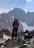
My son chimney-ed up the crack; I was able to climb up with out chimney-ing. I didn't think the exposure at this spot was concerning at all.

The views from the point of the Battleship were awesome. We signed the log book, rested a bit and then headed back. Hoped for a condor siting, but no dice this time. We made quicker time on the return trip, and it seemed that cairns were more helpful heading that direction.

By the time we got back to the 2 mi. switchback on BA, we were so happy to be done bushwhacking/route-finding that we happily tackled the remaining 1,400 ft. climb with gusto, knocking out the last two miles in a little over 20 minutes, each.

As we motored through the final tunnel about 1/4 mi. from the top, caked with 20 miles of grime, bobbing and weaving around those content to just dip their toe below the rim, and clearly on a mission to finish the trip, we still somehow managed to win the lottery and were selected by a couple of rim-hugging tourist to take their photo. My son graciously obliged, but I secretly held a little grudge, since our exit time was 9 hours, 30 min., rather than "sub-9:30." Ok, just joking. :lol: It was not that big a deal, but I really was surprised that of all the normal tourists, this gal asked the grimy, sweaty, hikers streaking to the top to stop and take their photo ...

After hot showers at Mather Campground, we packed up and headed back to the valley, another great GC adventure in the books.
_____________________
  2 archives
Mar 17 2017
avatar

 Guides 8
 Routes 12
 Photos 1,918
 Triplogs 662

39 female
 Joined Dec 02 2009
 Grand Canyon
Battleship - Grand CanyonNorthwest, AZ
Northwest, AZ
Hiking avatar Mar 17 2017
HippyTriplogs 662
Hiking7.50 Miles 3,200 AEG
Hiking7.50 Miles   5 Hrs      1.50 mph
3,200 ft AEG
 no routes
Linked   none no linked trail guides
Partners none no partners
Birthday butte with Jamie day before my birthday.
Popped a Guinness up top. Fun times!

Took "the high route" and found some seeps and springs in the Hermit contact area absolutely gorgeous.

Lots of bighorn evidence but no sightings this time.

Do not recommend the "high route" out from BA to the Ship's saddle unless you're down for some scree sliding excitement haha

Took the "middle route" back which is now the most traveled and obvious to follow.
First time I sailed the ship, 4 years ago??? Have I been here that long?! And nobody's tries to rescue me yet? ;)

Anyway, first time I did this butte the middle Trail was not nearly as defined.

Nowadays it's a single track with the occasional agave pointing the way!

Anyone else been up there lately?
_____________________
Canyon Freak Adventures!
 
May 15 2016
avatar

 Guides 1
 Routes 269
 Photos 613
 Triplogs 1,360

50 male
 Joined Dec 22 2003
 Tucson, AZ
Garden creek and Battleship, AZ 
Garden creek and Battleship, AZ
 
Hiking avatar May 15 2016
RedwallNHopsTriplogs 1,360
Hiking20.00 Miles 6,500 AEG
Hiking20.00 Miles
6,500 ft AEG
 no routesno photosets
1st trip
Partners none no partners
Nice weekend overnight. Descended Garden and stayed at BA campground. On the hike up, hiked up Battleship.
_____________________
 
May 08 2016
avatar

 Guides 37
 Routes 556
 Photos 10,872
 Triplogs 1,052

43 male
 Joined Jan 21 2013
 AZ
Battleship - Grand CanyonNorthwest, AZ
Northwest, AZ
Hiking avatar May 08 2016
FOTGTriplogs 1,052
Hiking7.18 Miles 2,500 AEG
Hiking7.18 Miles   3 Hrs   55 Mns   2.10 mph
2,500 ft AEG      30 Mns Break
 
1st trip
Linked   linked  
Partners none no partners
Who would have thought that I would see the top of this Battleship before the top of the one sitting in the middle of my beloved Supes? Although, I nearly missed seeing this summit over the weekend. I got snowed out and fogged out on Saturday and ended up having to bank on a relatively nice morning Sunday. Luckily, the conditions this morning were nearly perfect. Jackie stayed with the dogs on the rim and I hit Bright Angel about 20 minutes before six.

I was a little nervous using Route Scout for the hike, but it worked admirably. A quick wakeup hike down BA and then it was off the trail at the two mile switchback. The route is pretty well defined and cairned well, however, I did get a little high at points and found myself working back down towards the more established tread. The scramble up Battleship was a fun little challenge and the views were great. Whereas I was a little high on my route on the way in, I was a little low on the way out and actually came out on the switchback below the two mile switchback. Ooops. The route was cairned in spots and there was some semblance of tread, so I never thought to double check on my GPS, but it got me there, so nothing lost. Although, I should mention that route route does seem to expose one to a considerably higher amount of exposure than the official route, so I would just stick to that. Standard hike out and hail to accompany my final 2 tenths of a mile, like I said, nearly perfect conditions.
 Culture
 Culture [ checklist ]
[ checklist ]  Intrepid Back Shot
 Named place
 Named place [ checklist ]
[ checklist ]  The Battleship
_____________________
  3 archives
Jan 16 2016
avatar

 Guides 8
 Routes 12
 Photos 1,918
 Triplogs 662

39 female
 Joined Dec 02 2009
 Grand Canyon
Battleship - Grand CanyonNorthwest, AZ
Northwest, AZ
Hiking avatar Jan 16 2016
HippyTriplogs 662
Hiking13.00 Miles
Hiking13.00 Miles
 no routes
Linked   none no linked trail guides
Partners none no partners
Woke up early, or maybe late, I'm not sure. The sun wasn't up yet so I walked into the village from Tusayan via AZT which is a nice, what? 6 miles? *shrug*

So. Much. Snow. Whyyyyyy!!

Sun came up,had some coffee n baileys at BA Cafe then optes to head down BA until I felt like turning around.

Ended up at 2 Mile Corner, then ended up rebuilding the heart made of branches on the Battleship saddle and building a few tiny, melty snowballs.

I figured I'd walk out to the North point for photos but when I passed the uppass to the upclimb I ended up climbing up instead.

At one point my sister called delivering some bad news... "This is he call you've known was coming but never wanted to get"

My dad's scans and results came back...terminal. Weeks left.
Pardon the stains of my sorrow atop the Battleship.

And why do I mention this? Such a personal matter to the public that is HAZ?
Because the first part of mourning includes denial, beating denial is admitting the truth...next is acceptance.

Anyway. It was quite a calm, serene, peaceful place to receive such ugly news and I'm a hugger, I would've preferred having someone there to hug and let me cry on their shoulder.
But instead I had the Canyon, and that was just as calming.

Anyway...I climbed down, hikes out BA, hitched a ride to Tusayan with a Ranger friend and ended up being called in for a tour right as I got home...on my day off haha great day...overall... Beautiful day.
_____________________
Canyon Freak Adventures!
 
Sep 29 2015
avatar

 Guides 3
 Routes 569
 Photos 11,976
 Triplogs 1,634

50 female
 Joined Sep 18 2009
 Tucson, AZ
Phantom Ranch Ribbon Falls and Battleship, AZ 
Phantom Ranch Ribbon Falls and Battleship, AZ
 
Backpack avatar Sep 29 2015
GrottoGirlTriplogs 1,634
Backpack34.00 Miles 8,830 AEG
Backpack34.00 Miles3 Days         
8,830 ft AEG
 
1st trip
Met some friends at Phantom Ranch to share the 10 person cabin. The pipeline wasn't working so we didn't get to shower and we had to haul water to flush toilets. But that was a small price to pay to have AC when it's 103 out!

When Joel and I arrived most of our party had arrived. Two of our party didn't make it until after dinner. The fiancé had problems and was only hiking about 1 mile an hour. Unfortunately they had followed everyone else and had done the SK to Tonto to Bright Angel which is a lot for people not really used to hiking longer distances.

We stayed two nights and our middle day we hiked up to Ribbon Falls. The travertine dome is really cool! We stayed in the shade by the falls napping through the heat of the day.

During our trip we saw a few helicopters which reminded me of our fateful trip in November. It was hard to look at the rocks at the bottom of the gorge and not think of that night, as well. I figure over time things won't feel as raw.

Joel and I were to have spent two more nights in the Canyon but the heat would have been hard after getting used to the AC. So we climbed out with our full packets and dumped them for a side trip up Battleship. On the way we weren't on the main route and the going was slow. Joel almost stepped on a rattler. As we neared the route that goes up, Joel looked at one of the spots that wasn't the right one. He started towards it and I freaked out as it looked really hard and scared me. Thankfully, that was not the way and we found the correct class 3 route up which used a lot of caving moves. Soon we were on the top!

After our success, we went to dinner at the BA Lodge - had to wait FOREVER! Don't go! However, it was a good way to pass the time waiting for the couple who had a very slow ascent.

Overall, most of the group had a great time. It was a nice relaxing way to visit the Canyon. I can see why people like to stay in the cabins and have meals prepared for them :)
_____________________
 
Sep 29 2015
avatar

 Guides 1
 Routes 269
 Photos 613
 Triplogs 1,360

50 male
 Joined Dec 22 2003
 Tucson, AZ
Phantom Ranch Ribbon Falls and Battleship, AZ 
Phantom Ranch Ribbon Falls and Battleship, AZ
 
Backpack avatar Sep 29 2015
RedwallNHopsTriplogs 1,360
Backpack34.00 Miles 8,830 AEG
Backpack34.00 Miles3 Days         
8,830 ft AEG
 no routesno photosets
1st trip
It was hot.
_____________________
 
Apr 21 2015
avatar

 Guides 93
 Routes 397
 Photos 4,984
 Triplogs 4,124

49 male
 Joined Jun 20 2003
 Tucson, AZ
Battleship - Grand CanyonNorthwest, AZ
Northwest, AZ
Hiking avatar Apr 21 2015
fricknaleyTriplogs 4,124
Hiking7.28 Miles 2,012 AEG
Hiking7.28 Miles   4 Hrs   8 Mns   2.14 mph
2,012 ft AEG      44 Mns Break10 LBS Pack
 
1st trip
Linked   none no linked trail guides
Partners none no partners
i have wanted to do this for a long time. michelle got me a get out of jail free card and said go to the grand canyon so i did as i was told :)

i bounced between the upper and lower routes on the way out but it was still easy enough. really fun climb/scramble up to a fantastic summit. spent a good while up there. did a better job sticking to the lower route on the way back and motored back up to the top. weather was great.
 Culture
 Culture [ checklist ]
[ checklist ]  Summit Register Log
_____________________
hi
 
Dec 25 2014
avatar

 Guides 8
 Routes 12
 Photos 1,918
 Triplogs 662

39 female
 Joined Dec 02 2009
 Grand Canyon
Battleship - Grand CanyonNorthwest, AZ
Northwest, AZ
Hiking avatar Dec 25 2014
HippyTriplogs 662
Hiking6.50 Miles 2,400 AEG
Hiking6.50 Miles
2,400 ft AEG
 no routes
Linked   none no linked trail guides
Partners partners
cactuscat
What a great Christmas!!!
I'd always wanted to sail the Ship in the Supes with Cap'n Bootsie but 300miles prevents that from happening so...something even better!

I didn't want to stay home alone on Xmas day and I heard CactusCat was heading the same way as I was so at least I wouldn't be alone the entire trip!!

Microspikes ON until 2 mile corner. Met Matt and Dana two runners whom I share a mutual friend with. I breezed past them at the Cinch Up after sneaking past the mule train.

Set up my gopro at 2 mile corner and waited...why? No idea. I just did. Got some shots of the mules going by. Wrangler "Ted" asked me out for a drink :roll:

Not two minutes later I hear "Hippy?" Haha! CactusCat made it and after fruitcake and a photo with Matt & Dana who had also caught up, Cat and I were off.

Anything off the main trail is perfection to me and it was even better finally hiking with Cat after all these years!

The summit was easy as usual. Took some cool photos with the gopro, saw the ruins left behind by the tram workers back in the day, I'd never noticed those before!! Thanks Cat!!

Got snowed on. Had perfect lighting. Cat pulled a muscle early on on our way back but she went into beast mode and walked it off!
We reached BA and ran into Matt and Dana AGAIN and after a quick goodbye and having Cat promise to text when she was safe on the rim I flew uptrail...(due to her muscle and my time constraints I had to hike out asap)

Somehow I made it from 2 mile corner to the bar in Bright Angel Lodge in exactly 32 minutes. In the snow. I must've really wanted that post hike Margarita!!!

Thanks Cat for a great first hike and a Christmas hike too!!!
_____________________
Canyon Freak Adventures!
 
Dec 25 2014
avatar

 Routes 85
 Photos 3,718
 Triplogs 486

female
 Joined Oct 15 2002
 Rimrock, Arizona
Battleship - Grand CanyonNorthwest, AZ
Northwest, AZ
Hiking avatar Dec 25 2014
cactuscatTriplogs 486
Hiking6.50 Miles 2,400 AEG
Hiking6.50 Miles
2,400 ft AEG
 no routes
Linked   none no linked trail guides
Partners partners
Hippy
A few days ago I made plans for a Christmas day hike - a new friend was going to be on her way up from IG, so I was going to meet her at 2 mile corner and take her out to the Battleship.
Yesterday at work, Hippy mentioned that she was going to hike Battleship today. She was going to start a bit earlier than me, and as fast as she is I figured my buddy and I would cross paths with her out there on the route as she was on her way back.
I got bundled up this morning and started down the BA at around 9:15 in light snow flurries. Put on my microspikes right away ... saw a guy slip and fall on his pumpkin at the sign by Kolb studio. It was pretty icy, and there weren't many people on the trail - however I had the misfortune of starting down a few minutes after the mules ... I hung back a ways and took it slow since there isn't really a good place to pass them between Cinch-up and 1.5 mile resthouse.
I reached 1.5 mile and checked the time - 10:00, right when I was supposed to meet Constance at 2 mile corner ... so I hustled down. As I saw 2 mile from above, I could see someone sitting there, and assumed it was Constance. Nope - as I got closer, I could tell it was Hippy in a santa hat!
I called out "Hippy!" and after a moment she replied "Cat? You made it!"
We sat there and waited for about a half an hour, chatted with some passersby, and had some amusing trail commentary ... finally I got a text from Constance that she was just leaving the bunkhouse. I was like, well I can't wait that long in the cold - I'm hiking this one with Hippy! Lol - finally our first hike together after several years of being friends!
The hike out was great - some snow falling, but not too cold ... neither of us had done it in a while, but it only took a few seconds to remember how to negotiate the tricky climby parts. We hung out for a good long time on top goofing off and taking photos, and I showed her the little shelter up there, which she had never noticed before. It was beautiful up there, and a great way to spend part of Christmas!
On the way back to the trail I managed to tweak a thigh muscle, so that added a little pain and slowed me down a bit, but Ms. Schist was a good sport about it. When we reached the BA again, we ran right into a couple who we had chatted with on their way down in the same spot. I told Hippy to go ahead and jet up the trail - she had places to be, and I didn't even want to try to keep up.
I sat down and popped some Advil, sent a few texts, and chatted with another girl on her way up who we had said hi to earlier at 2 mile. After that, I got going and the thigh muscle was good ... I went slow but steady and barely stopped at all. Since I quit smoking, my cardio is improving and my Reynaud's is noticably better - my fingers are benefitting from the increased circulation and they don't get nearly as white and numb ... yay!
All in all, it was a great day and it was nice to finally hike with Hippy.
 Named place
 Named place [ checklist ]
[ checklist ]  The Battleship
_____________________
  2 archives
Sep 18 2014
avatar

 Guides 8
 Routes 12
 Photos 1,918
 Triplogs 662

39 female
 Joined Dec 02 2009
 Grand Canyon
Battleship - Grand CanyonNorthwest, AZ
Northwest, AZ
Hiking avatar Sep 18 2014
HippyTriplogs 662
Hiking9.30 Miles 2,635 AEG
Hiking9.30 Miles
2,635 ft AEG
 no routes
Linked   none no linked trail guides
Partners none no partners
They always tell you to exercise when you're feeling Ill...right?

So I did just that...but maybe they meant a short walk...not a short 9 mile hike in the Grand Canyon of all places.

I haven't posted my triplogs in MONTHS so time to play catch up starting with yesterday.
_____________________
Canyon Freak Adventures!
 
May 12 2014
avatar

 Guides 14
 Routes 9
 Photos 1,378
 Triplogs 287

61 male
 Joined Dec 20 2002
 Phoenix, AZ
GCNP Ribbon Utah Battleship, AZ 
GCNP Ribbon Utah Battleship, AZ
 
Backpack avatar May 12 2014
BarrettTriplogs 287
Backpack42.00 Miles 9,868 AEG
Backpack42.00 Miles4 Days         
9,868 ft AEG
 no routes
1st trip
Day 1 - 15.7 miles - After a breezy 44 degree night under the stars outside Tusayan, I entered the park early enough for it to be free and soon headed down the South Kaibab. Taking a break out on the Cedar Ridge end point, I let the Canyon sink into my brain for a bit before heading down to Phantom Ranch for lunch under a shaded picnic table. From there I continued up North Kaibab to Ribbon Falls, only to find it temporarily closed for a Zuni ceremony. I had to wait just around the bend from the falls with a guy named Randy from Macon, Georgia, who had been there 29 years ago with his brother. We lay on our backs in the shade, listening to the songs reverberate off the natural amphitheater overhead for an hour before we were allowed to finally enter. 8) Their creation story describes the first people emerging from the cave at the base of moss covered travertine monolith, and I personally can't think of a better place to call sacred than where we stood. I ducked into the cave, climbing to the window and poking my head out, the cold water a curtain in front of my view of the canyon beyond. :y:
Cottonwood Camp was only another 1.5 miles, so I set up camp and had dinner, returning for a sunset walk to the falls for some moonlight/LED photography. I can't say the pictures turned out very well, my sensor and LED's are too small and the falls are too big, but it made for an interesting adventure.
Day 2 - 8.6 Miles - After a morning trip to the falls, I cruised down North Kaibab to Phantom for another wonderful lunch under the shady tree before watering up (170 ounces) for my first trip up Utah Flats. The first half was like climbing a sand dune with a heavy pack, and Piano Alley was like climbing up a huge pile of (you guessed it) pianos with that same heavy pack. I found a nice flat spot at the saddle just southwest of the red rock basin, set up camp and soon was wandering around checking out the area. The small knoll just northeast of Piano Alley commanded awesome views in every direction, and I hung out there for the sunset. :D
Day 3 - 10.5 Miles - I had planned to bag Cheops Pyramid at dawn, but...
1) From where I stood, the southern ramp looked gnarly. My awesome wife K and I recently celebrated 25 years, and I'd like to be around to go for Gold.
2) My left heel, already sporting a whopper moleskin, did not like the look of that long off-camber talus approach one bit.
3) Bagging Cheops would mean I would miss the Golden Hour of light at the Utah Flats red rock basin.

Suffice to say I had a blast meandering around the sculpted forms with my new camera before breaking camp and heading back down. Another lunch at Phantom, this time under the shade tree just east of the stables near the silver bridge. From there it was up the Bright Angel, where I chatted up a group of Mung people in custom black silk uniforms ( :-k ), as well as joining Tom (Illinois), and Jenna (Tennessee) for the walk up to Indian Gardens.
At camp I met future HAZ member Roger from Phoenix, who had also planned his trip around the full moon. He was up for the trip out to Plateau Point for the sunset/moonrise, so we headed out and had a great time. After the sun went down, we had the place to ourselves, the conversation and beverages flowed. (simply mix Vodka with Indian Gardens water, add Smuckers Natural Concord Grape Jelly, shake vigorously until dissolved, and enjoy. Pretty Smuckin' good). The full moon walk back was the perfect last night in the Canyon.
Day 4 - 7.5 Miles - Roger headed out for a 26 mile dayhike to Granite Rapids (yeah, he'll fit in here on HAZ just fine), and I bopped up to the 2 mile switchback to access the Battleship route for my first trip there. Once again, my pack, though getting lighter, still made this less fun than it could have been. I carried it as far as the chimney, hoping it would be safe from critters for a few minutes while I went up. The climb was great, solid rock, little exposure, and a great summit. After taking in the scenery, I headed down, finding my pack undisturbed , and returned to the Bright Angel. The rim arrived soon, and I celebrated another safe return with the two Pyramid brews I had in my truck (still cool!), sitting below the edge along the Rim Trail by the Worship Site. 8)
A perfect trip. As always I'm torn between wanting to return to the same amazing places, or exploring new ones. Cheops looks much easier when viewed from the south, and someday I'll return. A dayhike from Bright Angel camp seems like a better way to do it.
Till then, I'll hike around Phoenix, and have some great adventures. But in the back of my mind, the Canyon will always call to me, a timeless sacred place that my words, my pictures, my videos will do no justice.

P.S. Not that I don't try. http://youtu.be/5O1toDCfdxI
 Flora
 Flora [ checklist ]
[ checklist ]  Utah agave
 Fauna
 Fauna [ checklist ]
[ checklist ]  Mule Deer
 Culture
 Culture [ checklist ]
[ checklist ]  Cag Shot  Ghost?
 Meteorology
 Meteorology [ checklist ]
[ checklist ]  Moon
_____________________
The past, the present, and the future walked into a bar.
It was tense.
 
May 07 2014
avatar

 Guides 8
 Routes 12
 Photos 1,918
 Triplogs 662

39 female
 Joined Dec 02 2009
 Grand Canyon
Battleship - Grand CanyonNorthwest, AZ
Northwest, AZ
Hiking avatar May 07 2014
HippyTriplogs 662
Hiking7.00 Miles 2,000 AEG
Hiking7.00 Miles
2,000 ft AEG
 no routes
Linked   none no linked trail guides
Partners none no partners
My afternoon tour was canceled because my riders weren't too happy with the "snow" so at 3pm I was cut loose. My manager and I rode our MTBs straight to BA TH and headed out.

The "snow" was sporadic and at times the sky seemed to froth and foam like a wicked sea!
Then all was calm... by the time we reached 2mile corner we opted for Battleship.
Two bighorns at the ships saddle!!! :D

Once we reached the up climb the calm sky broke open again with a brief torrent of puffy hail stones.
We decided to skip the summit but headed out to the North Pointe for a brief picnic on the edge in the rain.

The weather has been so strange, two weeks ago hot and calm. Then freezing and rainy, then freezing and windy, yesterday snowing with 50+ mph winds and today... sunny and warm with a gentle breeze.

Love it!!!
_____________________
Canyon Freak Adventures!
 
average hiking speed 1.77 mph
1, 2, 3  Next

WARNING! Hiking and outdoor related sports can be dangerous. Be responsible and prepare for the trip. Study the area you are entering and plan accordingly. Dress for the current and unexpected weather changes. Take plenty of water. Never go alone. Make an itinerary with your plan(s), route(s), destination(s) and expected return time. Give your itinerary to trusted family and/or friends.

helpcommentissue

end of page marker