|
| | | High Horton Knoll Babe loop, AZ | | | |
|
|
High Horton Knoll Babe loop, AZ
| | |
| |
|
| Hiking | 14.26 Miles |
2,529 AEG |
| | Hiking | 14.26 Miles | 6 Hrs 51 Mns | | 2.47 mph |
| 2,529 ft AEG | 1 Hour 5 Mns Break | | | |
|
|
| |
| Partners |
|
[ show ]
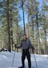
| partners | | Got started from the Hatchery trailhead to pleasant temps. East on Highline. Mostly easy rollercoaster the first few miles to Horton Spring. Plenty of shade. I lost my trekking pole along the way. Kind of bummed, but it was pretty beat up and probably due to be replaced (definitely not from REI) soon.
Took a break at Horton Spring, then headed up the steep Horton Spring trail straight up to the Rim. Steep, loose ground, not much shade, but at least I didn’t get bit by a dog on this trail this time around, so that was a plus. I took a million breaks. Kelly looked bored, but I had the vehicle key, so we all had to pretend breaks and breathing were a good thing.
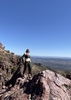
Once finally up top, we walked the Rim road over towards Knoll Lake. Took a break at a nice viewpoint at the edge of the Rim. Headed north on some road called Limestone something. Easy walking. Getting from that road over to the south end of Knoll Lake was a bit of an unknown. I had traced a route following an old road west, but wasn’t sure what the final descent down to the lake would look like. Turned out to be a pretty good track—the old road was good, and the final drop was easier and not as steep as expected.
At the lake, we had lunch at a campsite on the southern edge. Enjoyed the shade and watched the birds flying over the water. We finally left once some clouds started building. Headed south on Babe Haught. Cursed the one small climb. The descent off the Rim wasn’t too bad. The trail is very rocky, but okay when dry. We had a few sprinkles of rain, but nothing of concern. Smoke from the Preacher Fire had notably increased by the afternoon.
Good day for this loop, and fun company all the way around. |
| _____________________
| Stop crying and just go do the hike. |
| | |
|
|
|
 Route Editor


 Needless to say, it was enjoyable.
