|
| | | |
| |
|
| Backpack | 280.00 Miles |
70,000 AEG |
| | Backpack | 280.00 Miles | 25 Days | | |
| 70,000 ft AEG | | 40 LBS Pack | | |
|
|
| |
| Linked |
|
none
[ show ]
| no linked trail guides |
| Partners |
|
none
[ show ]
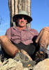
| no partners | | Did the John Muir trail northbound from cottonwood pass to yosemite village, ~ 280 miles 4 wks. We (myself and co-hiker) made 3 food stops at Independence (via Keasarge pass), "Muir trail ranch" , Mammoth (via mammoth pass, shuttle was down) We "summited" Whitney via the base of crabtree pass (getting down the pass is basically a slide down scree / sand). This is an off trail route involving an ascent of ~ 1k feet in pure granite sand and a 20deg + angle !! It was a one step ahead 3/4 step back deal. We finally made it to the Whitney portal trail after ~ 4 hrs. From there it seemed trivial to summit Whitney. My co-hiker didn't empty his boots in the sandy section and ripped the skin off the ball of his feet ! After a two day stop in Independence he decided to keep going against the advice of all he discussed it with. However he pushed on and made it. It's a hard route overall because of hikes up and down passes , almost one every day. Typically a 2-3k climb followed by a similar descent
immediately after. Every day amazing views, I find I prefer AZ scenery but it's definitely worth seeing the Sierras.
Weather was great except for the last two days involving a hail/lightning storm causing large fires a few days later but we were out just in time. The days were long because of the effort and starting too late ~ 9am and moving too slowly. The net result was
very little relaxation time which I did not like ! Guess I'll go back to solo backpacks. In any event it's a worthwhile effort if you're thinking about it. It's quite busy , saw about 20 people a day and camp spots can be busy so not really a 'wild' feeling. One night there were what sounded like huge explosions with ground tremors, probably rock fall. Another night I was sitting looking out and
a meteor passed by me at what seemed to be less than a mile away ! It was white hot in the front and blue in the back tail. After a. few seconds it broke into two pieces and then smaller 'sparks' appeared. It seemed to be headed for a nearby cliff but I didnt hear
a crash. I'll never forget that ! Did a little tenkara fishing, we caught about 6, all too small to eat but they pretty colors. I may do it again with my son before time runs out ! |
| _____________________
| | |
|
|
|
 Route Editor