 Route Editor

| Guide | ♦ | 14 Triplogs | 0 Topics |
details | drive | permit | forecast | 🔥 route |
stats |
photos | triplogs | topics | location |
| 204 | 14 | 0 |
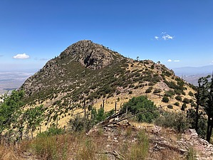
Once you go Mac, you just might go back by John10s  Overview OverviewPeak 8853, unofficially named 88 Mac, is one of several lower peaks located on the ridgeline near Crest Trail north of Mt. Wrightson. The 88 Mac nickname comes from a combination of the peak's approximate 8,800' elevation and its proximity to McCleary Peak (8,347') just to the north. The hike described here is an out-and-back route from Madera Canyon Trailhead, with most of the distance traveled on four trails: Pipeline, Kent Spring, Four Springs, and Crest. The final approach to the peak requires some relatively easy off-trail hiking with light scrambling; the hike's difficulty rating is primarily determined by the overall distance and AEG, with the vast majority of the route on well-maintained trails. Given the extensive network of trails in the Mt Wrightson Wilderness, there are many alternative routes to reach the peak and plenty of loop options available to extend the outing. 88 Mac won't be a main destination for most hikers, but it makes a nice addition to other hikes in the area.
From Madera Canyon Trailhead, start on Super Trail #134, then turn left onto Pipeline Trail #134 after about a third of a mile and continue gaining elevation while hiking next to the pipes that run alongside the trail. About a mile in, take a left onto Kent Spring Trail #157, which leads through a shady, forested area with some especially large sycamore trees near Sylvester Spring. At Kent Spring, turn right onto Four Springs Trail, which ascends through a single switchback and eventually turns to the northeast to climb through more switchbacks on a well-maintained, forested trail en route to Shovel Saddle, with improving views of Mt. Hopkins along the way. Approaching the saddle, Mt. Wrightson is visible through the trees, and there's an overlook a short distance off the trail northwest of the saddle that provides expansive views in that direction. The grade flattens out a little above the saddle as the trail leads north toward Armour Spring. The exit point for the social trail leading to McCleary Peak is located near the spot where Four Springs Trail turns east to circle the north side of Peak 8853. If you're looking for a more direct but steeper route to 88 Mac, you can leave the trail here and ascend the north side of the peak up to the summit. The official route described here continues east on Four Springs over to Crest Trail #144. Turn right (south) onto Crest and continue for roughly three-quarters of a mile to Pine Saddle, then leave the trail to start ascending the relatively gentle southeastern ridge leading to 88 Mac. The off-trail hike to the peak covers roughly a third of a mile and may require some light scrambling, but the rockiest terrain is easily avoidable. The flat-topped summit of 88 Mac offers 360° views that include Wrightson, Hopkins, and some of the lower peaks along the rocky ridgeline that extends south toward Wrightson. As of this writing, there's a summit register with entries dating back to the early 1990s. Once you're ready to start down, you can follow the same route back to the trailhead or consider extending the hike with various loop options or visits to nearby peaks such as McCleary, Mt. Ian, Rice Peak, or Wrightson. Check out the triplogs for potential route ideas. Check out the Official Route and Triplogs. Leave No Trace and +Add a Triplog after your hike to support this local community. | ||||||||||||||||||||||||||||||||||||||||||||||||||||||||||||||||||||||||||||||||||||||||||||||||||||||||||||||||||||||||||||||||||||||||||||||||||||||||||||||||||||||||||||||||||||||||||||||||||||||||


