Route Editor

| Guide | ♦ | 64 Triplogs | 0 Topics |
details | drive | permit | forecast | 🔥 route |
stats |
photos | triplogs | topics | location |
| 777 | 64 | 0 |
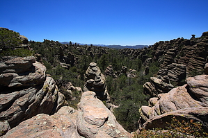
  Background BackgroundThe Chiricahua National Monument is not your typical sky island hike. Not by a long shot. This small section of the Chiricahuas is notable for its abundance of hoodoos. These natural wonders were formed by the Turkey Creek Volcano some 27 million years ago when eruptions melted together ash particles into layers of grey rock called rhyolite. Over the years, movement, weathering, and erosion worked up cracks, which let the weaker material wash away and leave us the gifts up the Monument...the hoodoos. The monument was established in 1924 to protect these formations wisely. In 1934 the Civilian Conservation Corps set to work building a set of trails to highlight the park's wonders. The park is very proud of this heritage and history. It should be; the CCC built an excellent set of trails that persists to this day. Looping together many of them in the high country by taking off from the Echo Canyon trailhead atop the Bonita Canyon Drive puts it all together into the beautiful Big Loop... the best of everything the park has to offer.
From the Echo Canyon trailhead parking lot, you can see the prominent, exposed Sugarloaf Mountain. To the northeast is the huge formation known as Cochise Head. To start the Big Loop, head down from the trailhead in the south end of the parking lot. You descend briefly and immediately comes to a signed intersection. Turn right onto the Echo Canyon Trail and get your camera ready. The trail immediately winds through hoodoo country, and there are hundreds of them in every direction from the get-go. The trail winds through them, around them, beneath them...wow! Views down Echo Canyon in particular are just amazing as you look southwest over thousands of hoodoos. The trail is easy to follow and is gently descending through here. Within about 1/4 mile, you come to the Grotto, where you can walk up to your right into a nice, small interconnecting covered maze of hallways. Afterward, the trail continues to descend into the canyon, passing by more amazing hoodoos. Soon after, you come to the narrow passageway known as Wall Street, another classic along the Echo Canyon Trail. After about a mile along the upper reaches of the trail, it descends more significantly into the forested canyon bottom as you reach Echo Park, a shaded fragrant forested wonderland. The trail is easy going through here. Pines, Arizona Cypress, and Arizona Madrone all lead you along. After a total of 1.6 miles on Echo Canyon, you reach a signed intersection for the Upper Rhyolite Canyon Trail and the Hailstone Trail. Descend onto the Upper Rhyolite Trail. There are huge views down Rhyolite Canyon on the upper reaches of this trail. The Rhyolite Canyon runs mostly west down all the way to the Visitor Center, which you can almost see. Initially, the trail runs beneath the rim up the canyon east, with fabulous views into the high country. A little over 1/4 mile, it swings back west and descends to the canyon floor, and enters the forest. This pine needle-littered and fern-flanked trail run along the wash, crossing over frequently. Heavily shaded, this trail is lined by pine, cypress, and some of the largest madrones I have ever seen. So sweet, it is sad to see the Upper Rhyolite Trail ends after 1.1 miles at an intersection with the Lower Rhyolite Canyon Trail and Sarah Deming Trail. Turn left onto the Sarah Deming trail, which will climb up the aptly named Sarah Deming Canyon for a total of 1.6 miles southeast back into the monument's high country. The higher you get, the better the views again become. You will climb about 800-900 feet along this trail, mostly on the south side of the canyon, then crossing over it near the top and climbing north away from the canyon and up towards the Heart of Rocks. As you top out near the Heart of Rocks, you will get your first view of Big Balanced Rock over the treetops. Whoa! At 6860 feet and the signed end of the trail, you will be at the junction with the Big Balanced Rock trail and Heart of Rocks trail. Take a left onto the 1.1 mile Heart of Rocks Loop. The Heart of Rocks Loop is worth the drive to the park itself. Only 1.1 miles in length, this trail offers many miles worth of scenery in such a short distance. It climbs up and mingles intimately with unbelievable hoodoos, including Pinnacle Rock, Camel Head, Old Maid, Thor's Hammer, and Punch and Judy. There are long, long views out to the Chiricahua Mountains and east towards the San Simon Valley. The path can be a little hard to follow. There are small red-painted footsteps to lead you along. At the end of the Heart of Rocks, you are back at the junction with the Big Balanced Rock trail. Head east on the Big Balanced Rock trail. Almost immediately, it passes its namesake Big Balanced Rock, an impossibly huge boulder balanced upside down on its pointy bottom. It doesn't even look possible, but there it is. Lunch here is not a bad idea. Beyond the rock, the trail continues east along mostly open country with nice views south towards the Chiricahua mountains. There's a lot of manzanita along the way. The trail is mostly level. After about 1 mile, an intersection with the Mushroom Rock Trail and Inspiration Point trail is reached. The Inspiration Point Trail is a short 0.5-mile spur out to an overlook offering great views. The Mushroom Rock Trail runs north and west as it descends about 600 feet along Hunt Canyon. This is a nice, shaded section of trail that offers nice hoodoo views up through the trees. About halfway along this trail, a small sign on the ground directs your gaze up through the trees to the magnificent Mushroom Rock. Perched high above the trees, it balances impossibly along the canyon top. After 1.2 miles, the Mushroom Rock trail crosses over the wash bottom and shortly climbs to the intersection with the Ed Riggs Trail and Hailstone Trail. Take a right on the Ed Riggs Trail and climb north back towards the Echo Canyon Trailhead. The lower Ed Riggs Trail passes through some neat hoodoos, one of which sits right next to the trail rising high above you. As you walk past it, you realize it is no more than a couple of feet wide. Ed Riggs was an instrumental character in the construction of the park, trails, and establishment of the Monument as a whole, and it is fitting that this last leg of the trail is named after him. The Ed Riggs trail will climb almost 400 feet back to the trailhead. Check out the Official Route and Triplogs. Leave No Trace and +Add a Triplog after your hike to support this local community. | ||||||||||||||||||||||||||||||||||||||||||||||||||||||||||||||||||||||||||||||||||||||||||||||||||||||||||||