| |
| White Mtn-Supes- partial, AZ | | -
-
-
-
| |  |
|
1 |
|
| | White Mtn-Supes- partial, AZ | | | |
|
|
White Mtn-Supes- partial, AZ
| | |
|
| Hiking | 9.02 Miles |
2,183 AEG |
| | Hiking | 9.02 Miles | 5 Hrs 18 Mns | | 2.03 mph |
| 2,183 ft AEG | 52 Mns Break | | | |
|
|
| |
| Partners |
|
[ show ]
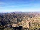
| partners | | The plan for today was to hike to White Mountain with Lee, then I would return to Rogers Trough, while Lee continued north on Reavis, finishing at the north trailhead. We got started around 7:00, and made good time up to the saddle. Plenty of flowing water along the way, but all crossings were easy. From the saddle, we headed up towards White Mountain. After a while, we decided that making the summit would put Lee too far behind schedule to finish his hike at a decent hour, so we took a snack break, then headed back down. I'm guessing we were 1/2 mile, maybe less, from the summit? I debated heading to the summit by myself while Lee turned around, but decided I really didn't care and chose to follow him back to the saddle. We headed our separate ways, and I took my time back to the trailhead. The bright sunlight didn't allow me to get good pics of the water, but I spent some time trying. I got back to my car a little before 12:30. Didn't see anybody else on the trail today, but the road on my way our was BUSY.
As far as the road, it is in what I would consider to be pretty typical condition. It has obviously received some maintenance since the last rain, as the heavy equipment tracks are still visible nearly the entire way. In my opinion, the worst section of the road is about 3.5-4 miles in on 172--that rocky section right after driving through the creek bottom for a short distance. Once you clear that short section, the rest of the road is rough, but not terrible. |
| _____________________
| Stop crying and just go do the hike. |
| | |
|
|
|
|
|
| |
 Route Editor


