| | -
| |  |
|
3 |
-
-
-
-
-
-
-
-
-
| |  |
|
3 |
-
-
-
-
-
|
| | |
|
| Hiking | 7.40 Miles |
1,971 AEG |
| | Hiking | 7.40 Miles | | | |
| 1,971 ft AEG | 15 Mns Break | 8 LBS Pack | | |
|
|
| |
| Partners |
|
none
[ show ]
| no partners | | This little Fitness Friday, pre-work hike should be named the Goodwin Fire Up Close and Personal. I have hiked this loop many times in the past and today was a shocker. 65 Degrees for my 545am launch.
Grapevine Canyon Road (which is just east of Milepost 274 on Highway 69) was washed out in places. 4WD and/or HPV necessary in a couple spots. Thats a new issue. I was to meet up with a guy from the Prescott Hiking Group, he was not comfortable crossing and I apparently was too occupied playing air guitar to AC/DC hauling pumpkin on the ride in to miss passing him.
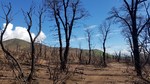
The forest road (87A) from the parking lot trailhead is unrecognizeable in many places... washed out or filled in ashy sand bars. It was nice to see the scrub oaks and the holly already growing lots of saplings from their burnt trunks throughout the affected fire area. Manzanitas were toast with no re-growth, buts only been a month.
The former Bulletin Board for Trail #4 has been burned down. No remants of the board though, wondering if the PNF salvaged it before the fire came through.
The entire hike there was that putrid musty water on a camp fire smell.
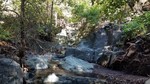
After taking a break on top of Battleship Rock atop Big Bug Mesa I began my freestyle drop down into the canyon. With much of the area devasted from the fire, you could hear the sounds of the water falls, which I overshot about 1/2 mile west, the drainage had deep cuts from the flooding (I was chasing the waterfall sounds). Tyson chased a pack of deer and was gone like a bullet. I had startled a baby deer which he missed. We reconvened in the drainage.
With the fresh rains Grapevine Creek was running good. Entire swaths of Trail #4 were washed away with exposed roots of the previous vegetation OR was covered over with flows of sandy mud and rock. Mother nature was pretty fierce on changing the water flow of the Grapevine Creek drainage. Previously all the springs fed into the Grapevine Falls, now the water drains on both sides with deep cuts and erosion throughout the area. The flooding must have been fiece. Much of the area was unrecognizeable. I estimate 1/2 mile from TH going WEST of the Grapevine Riparian Protected Habitat was completely burned...as you meander west up towards the springs that it was only slightly affected. More noted on photo comments.
The pictures do no justice. Come on up and check out this former "Baby Fossil Creek"... Highway 69 turnoff at Interstate 17 is Milepost 262, Grapevine Canyon Road is just before Milepost 274, then just a 2 mile meander to the TH. |
| _____________________
"Before there was a trail..... there was no trail" |
| | |
|
|
|
|
|
| |
 Route Editor


