| | -
-
-
-
| |  |
|
2 |
-
-
-
-
-
-
-
-
-
-
-
|
| | |
|
| Hiking | 7.43 Miles |
1,267 AEG |
| | Hiking | 7.43 Miles | 4 Hrs 57 Mns | | 1.65 mph |
| 1,267 ft AEG | 27 Mns Break | | | |
|
|
| |
| Partners |
|
[ show ]
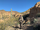
| partners | | Hiked up to Dome Mountain from Bulldog Trail Head. A couple years ago I attempted hiking up via the east slope to the saddle south of Dome Mountain, that was a nightmare. I headed back down not making it to Dome Mountain. I have since heard there was a route to Dome Mountain along the East Ridge and went that route on this hike. Nice route, easy to follow. May be easy to follow but it is steep. My plan was to do the loop that passes over Dome Mountain then head north along the ridge and back to the saddle east of Dome Mountain. I am not sure of the route from Dome Mountain north and east, all I had was a GPS route. Not sure weather this would be a hard bush whack or a route similar to the route up to dome. I was having second thoughts of dragging Ginny through this without knowing what I was getting into. I was even questioning getting her this far (she actually did really well, only fell once on the way down on the roller bearing rocks). My plan was to not hit dome summit but skirt around it just below the summit. When we got just below the summit we opted to not do the rest of the hike and return the way we came (it was noon). This decision was not totally because of Ginny, I was pretty pooped. To many flat lander hikes in Texas I guess or maybe I'm just getting old, I'm going with the former.
The views from this trail are fantastic from the get go at Bulldog Trail Head. Very colorful yellow lichen on the rocks on the way up to the saddle. Red and white arrows marking the already fairly obvious route are pretty faded now and won't be long before they area bad distant memory. Today was really clear and four Peaks showed up crisp and clear. |
| _____________________
| | |
|
|
|
|
|
| |
 Route Editor


