| | -
-
-
-
| 1 label | 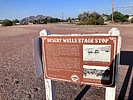 |
|
|
-
-
-
-
|
| | |
|
| Hiking | 4.91 Miles |
10 AEG |
| | Hiking | 4.91 Miles | 1 Hour 15 Mns | | 3.93 mph |
| 10 ft AEG | | | | |
|
|
| |
| Linked |
|
none
[ show ]
| no linked trail guides |
| Partners |
|
none
[ show ]
| no partners | | | Second hike of the daily double. Wanted to continue to work this connector trail. I parked on Hawes Rd and had to do some backtracking as I hiked up to Riggs Rd and then hiked over to Horseshoe Park and Equestrian Centre. After tagging these two areas I dropped down onto the horse path that acted as green belt as it made its way northwest through residential communities. This horse path was lower down than the surrounding terrain so I felt somewhat removed from suburbia. It was a dirt path which made it nicer to walk on and there was a decent number of trees and brush providing a little more isolation from the nearby homes. Felt like a lot of wildlife, but it was mainly rabbits. I lost count after 20. I did see a roadrunner which was too fast for me to get a picture. Went up to Sossaman Rd. and turned around. Interesting historical note. At the corner of Sossaman and Chandler Heights there is a historical site for an old stagecoach stop. There are still remnants of the building standing. On the way back I took the paved path which runs along the berm of the green belt. Saw about 10 users along the way. All of them were using the paved path. |
| _____________________
| | |
|
|
|
|
|
| |
 Route Editor


