| | -
-
-
-
-
-
| |  |
|
1 |
|
| | |
|
| Hiking | 7.70 Miles |
|
| | Hiking | 7.70 Miles | 1 Hour 59 Mns | | 3.88 mph |
| | | |
| |
| Linked |
|
none
[ show ]
| no linked trail guides |
| Partners |
|
none
[ show ]
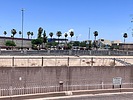
| no partners | | | Midday hike. I didn’t start moving until late in the day so decided to pick up where I left off on my last visit to the canal. Got to the Cactus parking lot near McDonalds around noon. Went from 51st Ave to the I-17. There are actually two canals (one is the cemented diversionary channel that is almost always dry and then there is the Arizona Canal flowing with water) that are very apparent on this segment. And there are walking paths that border each side of these channels. The path that is located between the dry channel and the flowing canal is the ideal path, primarily because it has designed underpasses at all the major road crossings. (If you walk either of the outer paths, you are forced to do road crossings and the most northern path is lost a couple of times to businesses or residences). However, the underpasses may not be the way to go as they are almost always home for squatters. I did the underpasses a couple of times and then decided to cross the roads thereafter. As expected, the views were underwhelming. Homes and businesses on both sides. In fact, I noticed one home had coiled barb wire along their fence which tells you all you need to know about the area. There were actually two bridges along this segment. The first was .3 miles in from 51st Ave and crossed the water canal. The second was about .85 miles in and crossed both waterways, probably because of a nearby school. Had the path to myself except for one biker and a couple of homeless people. Wildlife was minimal: ducks and a surprisingly active fish population in the canal. |
| _____________________
| | |
|
|
|
|
|
| |
 Route Editor


