|
| | | Cibola-Jordan and Soldier-Brins Mesa Loop, AZ | | | |
|
|
Cibola-Jordan and Soldier-Brins Mesa Loop, AZ
| | |
| |
|
| Hiking | 6.12 Miles |
1,296 AEG |
| | Hiking | 6.12 Miles | 3 Hrs 31 Mns | | 1.93 mph |
| 1,296 ft AEG | 21 Mns Break | | | |
|
|
| |
| Partners |
|
[ show ]
| partners | | After a fun nite with the Glacier Chatters, good nites sleep, breakfast and a beautiful drive on 89a to Sedona, we were at the TH. The road to the Jordan TH is pretty rough the last 1/4 mile or so but doable in a sedan; need to take it easy though. The TH seemed full but there are actually spots on the north end that don't have any No Parking signs so we picked one of those.
We had cloud cover most ot the day and the wind would pick up as we went up the pass. There would be quite a few people until after coming down from the Arches. I have to say, that's the most people I've ever seen when I've hiked there, which has only been two times; I thot I had hiked it three times. The scenery hits you in the face the minute you head north on Cibola Pass Trail looking at the Mitten Rock formation landmark. I remembered there was a bit of elevation gain to Cibola Pass. Fortunately, I had to stop and take a few pictures including of some pretty Paintbrush.
We hiked around and on some bedrock below the Sphinx and Morning Glory Spire to the Devil's Kitchen sinkhole of the 1880s. There were all sorts of people here. It is quite a marvel though. We spent a few minutes walking around it and observing. Continuing on the Soldier Pass Trail, next up, via lots of people and one red jeep, we made our way over to the Seven Sacred Pools that actually had water in them. The water looked dirty but photographed fairly nicely. Lots of people were taking it all in. Sadly, you really can't see the seven all at one time without trying to find a higher viewpoint and the right angle.
From there we headed through some forest with lots of AZ Cypress; love those trees. I didn't mark the Arches junction, but figured with all these people we should find it okay. Well it's not actually marked except for a sign that says trail and I think that's for the main trail. I did remember the big slab of bedrock (saw on satellite view) that you hike up on to start the rather rugged and somewhat dicey hike to the Arches. However, all sorts of people of all sizes and shapes were hiking it. Fortunately it is a not too long of an up, but there are also lots of people to navigate.
I took a different path than Kelly and I think it was better as it took you to the most northern alcove/arch first. It was really a cool geologic feature  . Kelly came down from where she was and went up in the alcove. Next we headed up and over to the main attraction, eventually climbing up to the ledge. I did need a boost as one rock was really hard to get up and I have a bum right leg. I asked a gal behind to give my behind a push and I was finally able to get up. It was worth the trouble and Kelly and I made our way to the other end. I got one really awesome photo among the several I took. The Arches were crowded, but everyone was kind. . Kelly came down from where she was and went up in the alcove. Next we headed up and over to the main attraction, eventually climbing up to the ledge. I did need a boost as one rock was really hard to get up and I have a bum right leg. I asked a gal behind to give my behind a push and I was finally able to get up. It was worth the trouble and Kelly and I made our way to the other end. I got one really awesome photo among the several I took. The Arches were crowded, but everyone was kind.
And now to make our way back down through the continous line of people still coming up. I think going here in the late afternoon would probably be the best light and maybe less people. We headed up the trail and the wind really picked up. I even had trouble getting my jacket on. I was worried that it would be even windier on the mesa where we wouldn't get any protection, but it wasn't too bad.
Once on the Brins Mesa Trail, we only saw two other people on the mesa itself. The trail is rocky from time to time and there is a slight rise. I usually do the hike over to the Knob. Kelly hasn't so she hiked on over while I found a comfortable seat on a downed tree from the fire of 2006. We finished off the mesa and started the trek down. There are about 3 steep and slightly slippery sections involving large step-offs. Luckily, there is plenty of scenery to enjoy. You just can't walk and gawk until you get to the bottom where the tread becomes much more reasonable.
We enjoyed our beers inside the warm comfort of Tonto 3 before heading to Sedona for lunch at the Pumphouse; but it was closed until dinner so we ate at Colt. We love the chairs there and the food is good too. I had a "I'll be your Huckleberry" but it wasn't very huckleberryish.
WATCH 5.41 mi, 9:32AM-1:03PM burning 1281 calories, 4612-5299 elevation. 124 avg bpm/157 max. Temp was a cool and windy 57.9 under cloudy skies and 48% humidity. |
| _____________________
For me, sometimes it's just as much about the journey as the destination.
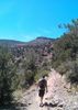
Oh, and once in awhile, don't forget to look back at the trail you've traveled. |
| | |
|
|
|
 Route Editor


 . Perfect weather, awesome hike, not too hard, not too easy