|
| | | Bryce Sunrise Point north, UT | | | |
|
|
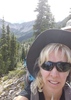
Bryce Sunrise Point north, UT
| | |
| |
|
| Hiking | 2.27 Miles |
325 AEG |
| | Hiking | 2.27 Miles | 1 Hour 1 Min | | 2.52 mph |
| 325 ft AEG | 7 Mns Break | | | |
|
|
| |
| Partners |
|
none
[ show ]
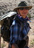
| no partners | | I was on the road to Montana but had planned to run up to Bryce before my drive north. I didn't want to do anything too long or hard so this was my choice. The great thing about hiking north from Sunrise Point is most of the people traffic goes right (south), thus I only ran into half dozen hikers for my hike.
The first thing that caught my eye was the trail riders going down the Queen's Garden Loop; they sure kicked up a lot of dust. After watching that for a bit I continued on my way. I took two little off-shoot trails along the way. As I rounded a corner I could see a rise and decided that would be my goal so I would get a little AEG.
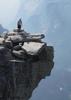
Even though it was slightly overcast, it felt warm and humid. However, the broken sky would provide for some interesting light which would make this place even more surreal. I remark in the video, "I wonder if there is any other place on earth like this?". I also noted that it's one thing to see hoodoos from a distance but even a better experience here because you can almost touch them. Everywhere you look is fascinating and it's hard to keep walking.
Coming back down the hill the light was changing so the scenery looked a little different. I headed over to the platform at Sunrise Point near where all the people gather. I took a quick look around and then headed back to the parking lot. An older gentleman said he and a few others were curious about my license plate so I told them the story of how Tonto got its name. By this time, it was very crowded and I was glad to be on my way. For my reference: https://www.usgs.gov/geology-and-ecolog ... ional-park
The drive out was really pretty as well so I continued to snap pictures and took a little video. I guess it would be nice to come up here for the day to hang out. Today, however, I had several hundred miles to drive. I would make it to Idaho Falls. Along the way I would see two different fires outside of Fillmore, UT so I snapped quite a few pictures. Even though there were only two fires, there were several plumes of smoke.
It really is a beautiful drive that I had just done in late May with cousin Connie. The other standout item was Gunsight Peak, part of the Malad Range (Clarkston Mountains). Oh, the clouds were pretty cool-looking for part of the day as well.
I tried to ID the mountains along the way but I'm not sure how well I did. When making the video, I would ask google to show me the mountain ranges around a certain city and try to ID them that way. Some of the peaks were easier to ID as I could change the terrain on google maps and try to line them up with my photos.
The other thing I learned while looking for hotels on my android auto is the prices listed are online prices so when I called a few of the hotels while driving, they would quote higher prices. Finally one hotel told me that the prices I'm seeing are online. So, at Idaho Falls, I pulled into the parking lot of Wendy's and made the reservation for Super 8 online and got the $105 price vs the $140 the hotel was charging.
As to fuel, if you are a member of Costco, you'll save a lot of money so it's a good idea to know where they are at along the route. I only made one boo-boo where I stopped at the corner on Highway 20 at the Sinclair where the price was the highest I paid. I noticed that Sinclair's prices seem to run higher than most stations.
Videos:
89 and 89A to Hatch, 12 to Bryce, first part of Bryce hike [ youtube video ]
second part of Bryce hike and Highway 12 [ youtube video ]
Highway 89, Highway 20, I-15 to Payson UT including Fillmore area wildfires (Panguitch, Little Creek and Sandy Peaks, Black Mountains, Tushar Mountains, Mineral Mountains, Pahvant Range, Fillmore fires (Halfway Hill and Dry Creek), Sunset Peak, Canyon Mountains, Mount Nebo, San Pitch Mountains, Owens Corning at Nephi, Clover Creek Solar at Mona UT, Wasatch Mountains.) [ youtube video ]
I-15 Payson to Inkom, ID (Payson, Wasatch Mountains, Spanish Fork, Brigham City, Malad Range (Clarkston Mountains), Gunsight Peak, Oxford Ridge, Boulder Mountains, Bannock Range, Portneuf Range) [ youtube video ] |
| _____________________
For me, sometimes it's just as much about the journey as the destination.
Oh, and once in awhile, don't forget to look back at the trail you've traveled. |
| | |
|
|
|
 Route Editor