username
X
password
register
for free!
help
ArticlesGuidesRoutes
 
Photosets
 
 Comments
triplogs   photosets   labels comments more
Canelo Hills West - AZT #3 - 19 members in 70 triplogs have rated this an average 3.3 ( 1 to 5 best )
1, 2, 3, 4  Next
70 triplogs
login for filter options
Mar 11 2025
avatar

 Guides 1
 Routes 262
 Photos 864
 Triplogs 266

51 male
 Joined Mar 24 2021
 Tucson, AZ
AZT Section Hike Episode 4: Pass to Highway, AZ 
AZT Section Hike Episode 4: Pass to Highway, AZ
 
Backpack avatar Mar 11 2025
JackluminousTriplogs 266
Backpack18.95 Miles 1,321 AEG
Backpack18.95 Miles   8 Hrs   56 Mns   2.70 mph
1,321 ft AEG
 
1st trip
Linked   linked  
Partners none no partners
Route Scout Route Recorded  on Route Scout | Pop | Map | Popup | MapDEX
Corey and I woke at dawn, made our breakfast, and set off by 7:30. With just the two of us, we were much better able to pack up and hit the trail. We chatted away the time, and kept a good pace. While the scenery on Passage 3 felt desolate and full of cow poop for long stretches, we had an enjoyable time. We encountered our first wildlife (other than a squirrel in the Huachucas) on this passage, a javelina very focused on munching a prickly pear growing beside the trail. It didn't seem interested in moving aside for us, so we found a way to go around it and leave it to its lunch.

We stopped at Red Bank Well to filter water, eat some calories, and for me to change my socks. My toe-socks were pretty rank, so this morning I'd tried hiking in my sleep socks. It didn't work so well, so I wound up changing back to my toe-socks to avoid getting blisters.

The first ten miles went pretty smoothly. The next five started getting hard. I have an old injury in my right leg that started acting up, and Corey was having trouble with his lower back. It was very sunny and hot, and there is pretty much minimal shade on this passage. We both felt the pressure to get to the parking lot by 5 so we could be home to our families in time for dinner.

We allowed ourselves a couple short breaks, the last about three miles from the end. Then we resolved not to stop until we made it to Keith at the parking lot. So we did. Then, at 4:30 on the nose, there it was, our gleaming chariot in the form of a white minivan! I wanted to hug it, but I settled for Keith instead. He had chips and water for us. Keith, you're the best!

On the drive home, I think I forgot how to walk...

water 1 out of 5water 2 out of 5water 3 out of 5water less than max Down Under Tank 51-75% full 51-75% full
water report recorded in the field on our app Route Scout Brown murky pond with lots of cow poo. Cement dam .1 mi NOBO has spigot and recent reports suggest clear water from it, but it was open and nothing coming out. Slimy pool below with more cow poo.

water 1 out of 5water 2 out of 5water 3 out of 5water 4 out of 5 Red Bank Well 76-100% full 76-100% full
water report recorded in the field on our app Route Scout Plenty of water here. Fill from the spigot in the open trough.
 
Jan 18 2025
avatar

 Routes 31
 Photos 4,724
 Triplogs 187

50 male
 Joined Mar 14 2016
 Gold Canyon, AZ
Canelo Hills West - AZT #3Tucson, AZ
Tucson, AZ
Hiking avatar Jan 18 2025
00blackoutTriplogs 187
Hiking19.25 Miles 1,292 AEG
Hiking19.25 Miles   7 Hrs   40 Mns   2.51 mph
1,292 ft AEG
 no routes
1st trip
Linked   none no linked trail guides
Partners partners
DarthStiller
mt98dew
wally
Chris invited me to head south yesterday to hike passage 3 of the Arizona Trail. With Wally and Brian joining we did a key swap with them starting at the Casa Blanca TH and Chris and I starting at the Canelo Pass TH. The temperature was in the upper 20s when we started just before 8 am. The first mile of the trail climbs a couple hundred feet to a small saddle then it's rolling hills for the next several miles. We passed Wally and Brian at 8 miles in, practically running up the trail :worthy:. I hit a 'wall' at 9 miles so we stopped for lunch at 9.5 miles and continued. At 11.5 miles the trail climbs around a ridge and has a couple of small ups and downs before ascending into a canyon. At the 16-mile mark, I hit another 'wall' and was fighting it for the rest of the hike as my feet were screaming at me at this point :cry:. Got to the Casa Blanca TH, changed out my shoes for flip-flops, and enjoyed a relaxing three-hour ride home. We came across two through hikers down in the canyon and besides a couple of deer and cattle that was it. Thanks, Chris for the invite and good seeing Wally again even though it was only for 5 minutes. :lol:

Note: I'm pretty sure RS is still broken when it comes to accumulating AEG, it was higher earlier in the day but as we down hill it declined. Chris's GPS came in at 1,800 AEG.

dry Cott Tank Exclosure - Red Rock Cyn Dry Dry
Nothing at the faucet.

water 1 out of 5water 2 out of 5water 3 out of 5water less than max Down Under Tank 51-75% full 51-75% full
Full but with all the cattle in area, I would strongly against filtering it.

_____________________
Hiking is just walking where it’s okay to pee. :y:
  2 archives
Jan 18 2025
avatar

 Routes 93
 Photos 7,758
 Triplogs 1,691

64 male
 Joined Mar 11 2003
 AZ
Canelo Hills West - AZT #3Tucson, AZ
Tucson, AZ
Hiking avatar Jan 18 2025
wallyfrackTriplogs 1,691
Hiking19.10 Miles 2,728 AEG
Hiking19.10 Miles   6 Hrs   1 Min   3.32 mph
2,728 ft AEG      16 Mns Break
 no routes
1st trip
Linked   none no linked trail guides
Partners partners
00blackout
DarthStiller
mt98dew
wally
Chris had a good plan for this shuttle hike and the weather was great. Brian and I hiked north to south and even thought we gained an extra 1091 feet AEG the average grade was about 3%. The trail is in good shape, there a few spur trails to avoid and several cow mines. We saw Chris & Jason on our mile 11 about 10:49am. Although I never saw it, I'm pretty sure there was a bear chasing us because Brian was cruising and I has keeping up. I haven't hiked this far at this pace in a long time. (the Wally of old) :lol: We stopped to talk to a couple that had dropped a shuttle vehicle and were during an overnight hike on this section and saw another couple hiking in as we neared the finish. I left most of my snacks on the kitchen table ](*,) so we only took about a 10 minute break to refuel. Brian had some leg cramps toward the end so I took the lead (still no shame). We finished about 1:35 and since we both had keys to both vehicles we brought the Xterra over to the north TH for Chris & Jason when they finished and started back. Great weather, good company and one heck of a pace.
_____________________
  2 archives
Jan 18 2025
avatar

 Guides 27
 Routes 669
 Photos 12,096
 Triplogs 856

56 male
 Joined Jul 05 2006
 Mesa, AZ
Canelo Hills West - AZT #3Tucson, AZ
Tucson, AZ
Hiking avatar Jan 18 2025
DarthStillerTriplogs 856
Hiking19.20 Miles 1,645 AEG
Hiking19.20 Miles   7 Hrs   52 Mns   2.58 mph
1,645 ft AEG      25 Mns Break
 
1st trip
Linked   none no linked trail guides
Partners partners
00blackout
mt98dew
wallyfrack
This was the first key exchange hike I've ever done. Wally and I drove, and Jason and Brian were the passengers/company. Wally and Brian started from the Casa Blanca Canyon TH and headed south, Jason and I started from the Canelo Hills TH and headed north.

Jason and I had a good 8 miles of driving to go when I got the text from Wally letting us know they were starting to hike. Between that and their faster hiking pace, we met them on the trail when we got 8 miles in they were over 11 in. Brian was visibly in "go mode" and Wally actually seemed a little exasperated trying to keep up. Jason was ahead of me the whole time and he was already gone and past them. I met him a half hour later and we had lunch before finishing up.

Jason and I made pretty decent time for us, but we were no match for Wally and Brian who finished hiking at 1:30pm and had enough time to drop off the Xterra at the Casa Blanca Canyon TH where we finished. The key exchange saved everyone time and I was home by 7. Most of the drive home was in the daylight, which I hadn't expected. Wally was waiting in his garage for us when we got back to his place when I dropped off Jason and we swapped back the extra sets of keys.

Weather was very cool the entire time, which really helps on longer hikes like this. Jason and I saw 2 SB thru hikers and Wally said he and Brian saw a couple groups of NB thru hikers, who were either ahead or behind us because we never saw them. Meadow Vally had the nicest scenery at the start. Typical rolling hills from there on out, but still very peaceful and remote. Lots of roads we followed on this segment, making me think that one day I'll need to go back to rehike if they re-route as they say they will to convert everything to singletrack.
_____________________
 
Jan 18 2025
avatar

 Guides 69
 Routes 37
 Photos 3,010
 Triplogs 2,387

55 male
 Joined Oct 24 2010
 Phoenix,Az
Canelo Hills West - AZT #3Tucson, AZ
Tucson, AZ
Hiking avatar Jan 18 2025
mt98dewTriplogs 2,387
Hiking19.10 Miles 2,728 AEG
Hiking19.10 Miles   6 Hrs   1 Min   3.17 mph
2,728 ft AEG
 no routes
1st trip
Linked   none no linked trail guides
Partners partners
00blackout
DarthStiller
wallyfrack
Sometimes I am my own worst enemy. I headed out to southern Arizona with Chris, Jason and Wally to knock out another section of the Arizona Trail. We all met over at Wally’s as our rally point. Wally and Chris were going to drive to separate ends of the trail and we were going to do a key exchange when we passed each other. This really is a great way to handle some of these longer sections. However, in my haste to exchange vehicles I forgot a couple of key components. My Garmin, and even worse…….my hiking shoes! ](*,) ](*,) I was wearing a pair of Sketchers. Honestly, I already hated these shoes going into the hike. At best, these are house shoes. They certainly have no business being on a trail. :lol: Not having the Garmin was disheartening, but not nearly as debilitating. I was hiking with Wally who had the route and I could get the stats from others on the hike. Sigh.

Wally and I got started from the Temporal Gulch TH around 7:40. In a way, not having my Garmin is rather “freeing”. I usually spend quite a bit of time trying to note various features of a trail: when you cross a road, pass through a gate, join a dual track. Not the case today. My goal was to try to do this hike as quickly as possible. I figures the less time spent on my feet the better. :lol: There is a short connector trail to get to the Arizona Trail and then, turning south, we quickly went under the 82. From here the trail did a great job in meandering in a southeast direction, frequently avoiding the hills and taking the path of “least elevation.”The trail was pretty easy to follow and was well signed for the most part. There were several roads, cow paths and even official trails that intersected the Arizona Trail, but frequently there was a carsonite marker or a gate emblazoned with the AZ trail logo within .25 miles of the intersection to let you know that you were on the right trail. We were about 7 miles in when we junctured with the Hathway(?) Trail. Unsure about the name, but the juncture had a signed map. We probably crossed and/or joined a half a dozen roads. All interactions were well signed, except 1 (near a water tank), where Wally caught the trail leaving the road. (It was a heavily trafficked cow area, so you had to be paying attention). I’m guessing around 13 miles in, there were remnants of an old homestead. The brick walls still stood fairly tall. Hard to believe anyone making a life in that setting. Shortly after that we came to a relatively modern water tower. It had solar panels and a non-working water faucet.

I did pretty well for most of the hike, considering the circumstances. The feet started complaining about 12 miles in and then my quads started to cramp around mile 17. The last two miles I did my best to try to keep my feet and quads from rebelling. All things considered, a nice hike. A little chilly at first, but that probably helped numb the foot discomfort. Nice hiking with Wally. Good company and definitely makes for a quick hike. Including Chris and Jason, only saw 6 other hikers on the trail. Sadly, no wildlife on the trail, though I did see 3 deer and a good sized javelina on the drive.
_____________________
  3 archives
Nov 30 2024
avatar

 Guides 187
 Routes 989
 Photos 12,068
 Triplogs 864

72 male
 Joined Jun 27 2015
 Tucson, Arizona
Canelo Hills West, AZ 
Canelo Hills West, AZ
 
Hiking avatar Nov 30 2024
markthurman53Triplogs 864
Hiking12.43 Miles 1,457 AEG
Hiking12.43 Miles   7 Hrs   33 Mns   1.86 mph
1,457 ft AEG      53 Mns Break20 LBS Pack
 
1st trip
Linked   linked  
Partners partners
mamakatt22
Ginny and I have been doing sections of the Arizona Trail for the last 2 years. One of the sections we haven't done is the Canelo Hills West, east end. We started at Canelo Pass and headed west a little over 6 miles before heading back. When I did this section of the AZT back in 2013 I was really impressed with the area, beautiful country. The trail has been rerouted since then in some areas especially on the far west end. This portion we did today hasn't changed.

Very dry on this trip with water in the Down Under Tank and a small trickle in the creek just a quarter mile downstream from it, dry every where else, even at Cott Tank although the faucet there had water. We ate lunch at an old windmill just about a half mile from Red Rock Canyon. Returned the way we came.

Saw two AZT southbound through hikers on the way in, they didn't appear to be together. Couple of vehicles glassing the area for I guess the upcoming deer season (We saw two pretty good size white tailed). Stopped and talked to a couple that were in one of those small off road vehicles and asked how they got into this area, turns out the forest service has opened a new route (Meadow Valley Road) along the Harshaw road in the northern part of the San Rafael Valley . Looked on line for more info but couldn't find a map. Will have to do more research because it would be a good way to access the middle portion of the Arizona Trail Canelo Hills West. Terrific hike with excellent weather.
 Named place
 Named place [ checklist ]
[ checklist ]  Cott Tank

dry Cott Tank Exclosure - Red Rock Cyn Dry Dry
Faucet there had water but the creek was dry

water 1 out of 5water 2 out of 5water less than maxwater less than max Down Under Tank 26-50% full 26-50% full
_____________________
 
Nov 11 2024
avatar

 Routes 386
 Photos 49
 Triplogs 792

43 female
 Joined Jun 23 2015
 Phoenix, AZ
Canelo Hills West - AZT #3Tucson, AZ
Tucson, AZ
Hiking avatar Nov 11 2024
emilystardustTriplogs 792
Hiking19.82 Miles 1,436 AEG
Hiking19.82 Miles   8 Hrs   7 Mns   2.70 mph
1,436 ft AEG      47 Mns Break
 
no photosets
1st trip
Linked   none no linked trail guides
Partners none no partners
Route Scout Route Recorded  on Route Scout | Pop | Map | Popup | MapDEX
Dayhiked passage 3 as a plan c. Soft rolling hills and not too challenging aside from mileage. We only saw about 7 southbound thru hikers in terms of people for the day.
_____________________
 
Apr 27 2024
avatar

 Guides 1
 Routes 61
 Photos 604
 Triplogs 79

male
 Joined May 28 2019
 Phoenix, AZ
Canelo Hills West - AZT #3Tucson, AZ
Tucson, AZ
Hiking avatar Apr 27 2024
kyleGChikerTriplogs 79
Hiking22.17 Miles 4,227 AEG
Hiking22.17 Miles   9 Hrs   17 Mns   2.59 mph
4,227 ft AEG      44 Mns Break20 LBS Pack
 
1st trip
Linked   none no linked trail guides
Partners none no partners
Sorry for the lack of triplogs recently. In the last year, I've been laid off from my job twice, got engaged in December and married in July (honeymoon was in Banff National Park, Canada!), not to mention several trips for foreign countries for ministry and volunteer work.

Anyway, this hike was a few months ago, but I still wanted to write a brief triplog and include a GPS track and photoset.

Mom and I are continuing to check off the Arizona Trail passages. We hiked #3 and #4 over a weekend. It was a tough weekend doing both of them back to back, but for hikers in reasonably good shape, it is still doable. Between the two passages, both were incredibly beautiful, but what really stood out from passage 3 was the great wildlife. We saw several flocks of wild turkey, a snake, and also lots of wildflowers.
wildflower observationwildflower observationwildflower observationwildflower observationwildflower observation
Wildflowers Observation Moderate
Cacti in full bloom
 
Jan 20 2024
avatar

 Guides 12
 Routes 192
 Photos 863
 Triplogs 356

42 male
 Joined Nov 30 2015
 Phoenix, AZ
Patagonia loop, AZ 
Patagonia loop, AZ
 
Run/Jog avatar Jan 20 2024
ShatteredArmTriplogs 356
Run/Jog20.00 Miles 2,000 AEG
Run/Jog20.00 Miles   5 Hrs   35 Mns   3.60 mph
2,000 ft AEG      2 Mns Break
 no routesno photosets
1st trip
Linked   linked  
Partners none no partners
Weather seemed nice to check out some of the rerouted AZT, so I headed down to Patagonia with the plan to do a loop utilizing the rerouted part of Passage 3. Didn't feel great, feel like I might be sick. Decided to get Harshaw Road out of the way first, which went quickly enough. Several cars parked at the Harshaw TH, which gives me hope that the connector won't be totally abandoned.

The trail that's now the Harshaw Connector was prettier than I recalled, and offered the best scenery of the day. Saw a couple of hikers and MTBs on this stretch. Then onto the new section, which heads north and after a flat mile or so, starts a gradual climb up to a pass. One stretch along a south-facing slope looks like a ton of work had to go into it.

Was hoping the downhill would be pleasant, but in true MTB-trail fashion, they can't have it go downhill for too long without putting in some minor ascents. That would make it too hard to ride in the uphill direction. At any rate, by the time I got to the ranch boundary, I was ready to be done. All told, I wasn't a huge fan of the rerouted section, although I understand the goal to get the trail off of Harshaw Road.

Found the Railroad Grade Trail right at the highway culvert, which was unmarked but obvious. The section of trail was basically flat, not overly sinuous, but still pretty miserable because at this point I was hurting, feeling worse than at the start, and clearly not in good enough shape for a 20 mile run. To my pleasant surprise, the existence of this trail (which has AZT signs here and there) made it possible to almost entirely avoid the highway, since it pops out right at the Sonoita Creek bridge in Patagonia.
_____________________
  1 archive
Mar 31 2023
avatar

 Guides 1
 Routes 1
 Triplogs 24

45 male
 Joined Feb 27 2012
 Cochise County
Huachuca Mountains - AZT #1Tucson, AZ
Tucson, AZ
Backpack avatar Mar 31 2023
AndrewAZTriplogs 24
Backpack51.60 Miles 8,140 AEG
Backpack51.60 Miles2 Days         
8,140 ft AEG
 no routesno photosets
1st trip
Partners none no partners
I was dropped off at Montezuma Pass on 3/31 with the goal of getting to Casa Blanca Canyon TH on 4/1 at 7pm. I started walking at 7:45am. 35 hours would be enough time for 52 miles, right?

The first 2 miles up to the juniper point reminded me why I go in from Miller Canyon for my Huachuca hiking if I can. Some blowdowns and snow between there and the Miller Peak turnoff. I've done Miller Peak several times, so I passed this time given the time constraints. About 3/4 of a mile of snow after Miller, and then a good stretch of mud.

Passed 2 thru-hikers, Bonnie and Clyde, at Bathtub Spring. The Crest Trail was scenic as always. A drainage just past the Ida Canyon trail junction had flowing water--never seen that before.

My memory from doing the whole AZT a decade ago was that Sunnyside was an immediate descent and quick stroll to the wilderness border. I award my memory half points. It's definitely a sharp drop, but a much longer walk along the canyon then I remembered. No complaints about that longer walk since there was flowing water from before the stone wall until the wilderness boundary. Very different than on my thru-hike (a few algae pools is all I recall seeing). I first passed another 2 thru-hikers, Regular Guy and Baby, in this stretch, and then we leap-frogged several times.

After the wilderness boundary, my memory was a long network of annoying dirt roads to get to Parker Canyon Lake TH. Zero points for my memory. I had no memory of Scotia Canyon, so I'm glad I did it again and got to enjoy it. Even with the controlled burns going on (a very good idea--so much fuel out there), it was a lovely walk. A bit of dirt roads (and a large, full-to-bursting windmill tank off to the left), and then I was at Parker Canyon Lake TH.

I met a couple there doing trail magic, and trail support for their daughter. They had all kinds of beverages and treats, but I limited myself to some water and a homemade snickers bar (although the canned iced coffee was so tempting). Very generous of them.

I made it to Parker Canyon (more flowing water) and then took a wrong turn down the creek to get some bonus miles. I figured out my error but decided to call it a day since there were good campsites and I knew any future campsites for the next few miles would be dry. I camped near another thru-hiker, Noah, but we didn't talk much. According to my old databook, I had done about 22 miles. Not a bad start.

I was rolling at 6am on 4/1. Perfect walking temperature before the sun was on me. My memory said AZT #2 was a never-ending series of hills, and it was correct this time. So many hills, and the climb to the high point was a hot one. A fast descent to the Canelo Hills TH, and AZT #2 was done. I had loaded up on water from Parker Canyon, but topped off a little from the TH cache.

I remembered the views along #3 being some of my favorite on the southern stretch of the trail, and they delivered again. Big sweeping views of grasslands + many mountains = perfect. It helped that all the grass and thorn brush had been thoroughly whacked away from the trail. Yay for trail crews.

I first passed an 83yo thru-hiker in this stretch (didn't get his name), and we leap-frogged for several hours. I hope I'm still out hiking like him at that age.

I remembered not being a big fan of the 4x4 road walking last time, but it was much improved this time by having water everywhere (to the point that some wash crossings were tricky). A totally different trail experience from a decade ago. People thru-hiking it this year are so lucky.

I stopped for more water at Red Bank Well. It no longer sprays out the side like it used to, but pressing the float on the trough worked. I probably could've made it to the end with what I had, but I didn't have the mileage numbers for the new trail stretch and decided to play it safe. Shortly after Red Bank, I saw a flock of 12 turkeys off to the side of the trail.

I left Red Bank around 2:30 and was feeling the time crunch, especially since I didn't know the exact distance to the end. I hit the sign where the old & new trail split, and was thrilled to discover it had zero mileage information on it (aside from a scale which was obviously inaccurate). I was also thrilled to discover the new trail appeared to have a bad case of the meanders.

Granted, I was trying to make miles, but I was less than impressed with the new stretch. Meandering, dry (a feat given all the water out there right now), and meandering. Not a section I'll feel the need to repeat soon.

I rolled into Casa Blanca Canyon TH at 6:45pm. I had enough time to rearrange my gear, drink some water, and then my ride was there at 7pm. About 30 miles in 13 hours for the second day, and 52 miles total in 35 hours. I can live with that.

Misc:

--I was surprised how big the packs were on the thru-hikers I saw. My gear isn't particularly small, but I was super-ultralight in comparison. Even if I had gear for a longer thru instead of an overnight, I would've only had another 1.5 pounds or so.

--a nice amount of poppies in the stretch between Red Bank and the trail split, but no mariposa lilies yet.

--so much water, and much better signage than a decade ago. It felt like easy mode compared to the AZT I remember.
_____________________
 
Mar 11 2023
avatar

 Guides 11
 Routes 123
 Photos 818
 Triplogs 257

62 male
 Joined Jul 14 2011
 Tucson, AZ
Canelo Hills West - AZT #3Tucson, AZ
Tucson, AZ
Hiking avatar Mar 11 2023
Mountain_RatTriplogs 257
Hiking19.23 Miles 1,782 AEG
Hiking19.23 Miles   7 Hrs      2.88 mph
1,782 ft AEG      20 Mns Break14 LBS Pack
 
no photosets
1st trip
Linked   none no linked trail guides
Partners none no partners
Official reroute as of sometime in 2022.

water 1 out of 5water 2 out of 5water 3 out of 5water 4 out of 5 Cott Tank Exclosure - Red Rock Cyn 76-100% full 76-100% full
Spigot is on an the water is great

water 1 out of 5water 2 out of 5water 3 out of 5water 4 out of 5 Down Under Tank 76-100% full 76-100% full
Full, as usual. Stream to the west is intermittent all the way to Cott Tank

dry Gate Spring Dry Dry
No sign of it

dry Lampshire Canyon Dry Dry
Damp sand is about it.

water 1 out of 5water 2 out of 5water 3 out of 5water 4 out of 5 Red Bank Well 76-100% full 76-100% full
Overflow pipe was running, so the tank is pretty full. Who knows when that could change. This could be last chance water until Patagonia right now.

water 1 out of 5water 2 out of 5water less than maxwater less than max Redrock Canyon Light flow Light flow
Just dirt west of Lampshire Canyon. Intermittent stream to the east.
_____________________
🥓🥓🥓
 
Jan 29 2023
avatar

 Guides 187
 Routes 989
 Photos 12,068
 Triplogs 864

72 male
 Joined Jun 27 2015
 Tucson, Arizona
AT3 Harshaw Road to Gate Spring, AZ 
AT3 Harshaw Road to Gate Spring, AZ
 
Hiking avatar Jan 29 2023
markthurman53Triplogs 864
Hiking12.24 Miles 2,007 AEG
Hiking12.24 Miles   7 Hrs   8 Mns   1.79 mph
2,007 ft AEG      17 Mns Break
 
1st trip
Linked   linked  
Partners partners
mamakatt22
It has been a bad January for me as far as hiking goes, only 29 miles this month. Between The Navajo Rug weaving and work around the house I haven’t got much hiking in, I finished the rug and the roof work is done so maybe February will be a better month for hiking. Ginny and I did the western portion of the Arizona trail in the Canelo Hills from Harshaw Road to near Gate Spring. Good weather for this hike, Monday Through Wednesday it is supposed to rain.

This is a scenic hike through Oak, Mesquite grassland with riparian areas along Redrock Canyon. I always considered the Conelo hills trail to be rather easy walking and not much elevation gain but this section of trail does have a lot of AEG as you pass by Kunde Peak. I noticed that a section of the Arizona Trail was rerouted to move the trail out of the Redrock creek just prior to Gate Spring. We returned along the old trail which is pretty much gone now. January isn’t the best time to hike this area because all the growth is dormant, the upside is the weather is cooler this time of year. I noticed a sign indicating the Arizona Scenic trail that branches off from the Arizona Trail after following it from the east. It leaves the AT, heads in a northerly direction toward Patagonia. Looks like another trail I will have to check out.
Light flow in sections along Redrock Canyon, usually where the bedrock surfaces along the creek.
_____________________
 
Nov 15 2020
avatar

 Guides 10
 Routes 673
 Photos 7,281
 Triplogs 4,660

67 female
 Joined Nov 17 2008
 phoenix, az
Azt #2 & #3, AZ 
Azt #2 & #3, AZ
 
Backpack avatar Nov 15 2020
trekkin_geckoTriplogs 4,660
Backpack30.20 Miles 3,800 AEG
Backpack30.20 Miles2 Days         
3,800 ft AEG
 no routes
1st trip
Partners partners
johnlp
two day backpack of azt passages two and three
john and i utilized ken's shuttle service to go from patagonia to parker canyon lake

day one:
got going around 0815 sunday morning
canelo hills east was scenic with rolling hills, distant mountain views and a variety of trees
we stopped for a coffee break about halfway to canelo pass
think we saw three thru-hikers on this part
public water was available at the trailhead, so we grabbed a couple of liters
after a short break, we continued on canelo hills west, intending to filter at down under tank and then find a place to camp
the trail is nice for a couple miles, then catclaw encroaches on the trail and covers the hillsides
several miles of this passage were not very pretty
went on to the cott enclosed area, and got four liters from the spigot before the solar powered pump stopped working due to lack of sun
between lack of appealing campsites and not having quite enough water, we continued on to red bank well, which had good water amid a lot of cows
found a campsite just after that, leaving us with about half an hour to set up
the stars were unbelievable without any moonlight, and even the milky way was visible
temps dropped quickly, so we settle into our tents early
my coffee filter had ice crystals on it in the morning :o
survived the night in my 30 degree bag, wearing a short sleeve, long sleeve, fleece, puffy and beanie
could use some base layer pants under my nylon ones
good learning experience - always like to practice backpacking

day two:
coffee and oatmeal, packed up and set out around 0715
cold in the drainage, and still not very nice trail
things warmed up and the scenery improved after a couple of miles
good views of red mountain and the santa ritas at times
saw a few thru-hikers and three day hikers
dropped down to harshaw road
not the most exciting finish, but at least there wasn't much traffic
finished up and headed for the cafe in sonoita
good green chile burger and sweet potato fries - highly recommended :)

i like the shorter second days
new gear for this trip included a smart wool beanie and a mont bell wind shirt
nice to get a couple more passages done
thanks john, another great trip!

*route scout mileage seemed a little high again, so i'm using stats from guthooks and the haz description page
there has been a slight reroute on passage #3 and the official route is just a bit off

water 1 out of 5water 2 out of 5water 3 out of 5water less than max Cott Tank 51-75% full 51-75% full
pump is solar powered
no sun = no water

water 1 out of 5water 2 out of 5water 3 out of 5water less than max Down Under Tank 51-75% full 51-75% full
good enough water
cows trample around the edges

water 1 out of 5water 2 out of 5water 3 out of 5water less than max Parker Canyon Creek @ AZT 2 Medium flow Medium flow

water 1 out of 5water 2 out of 5water 3 out of 5water less than max Parker Canyon Lake 51-75% full 51-75% full
just a guess, i don't know how full it should be
_____________________
hazhole
  4 archives
Nov 15 2020
avatar

 Guides 1
 Routes 14
 Photos 7,202
 Triplogs 5,208

68 male
 Joined Mar 16 2008
 chandler,az
Azt #2 & #3, AZ 
Azt #2 & #3, AZ
 
Backpack avatar Nov 15 2020
johnlpTriplogs 5,208
Backpack30.20 Miles 3,800 AEG
Backpack30.20 Miles2 Days         
3,800 ft AEG
 no routes
1st trip
Partners partners
trekkin_gecko
Finally knocked these two AZT segments out. Been on the list since the crazy adventure I had with JJ doing segment #1 in 2012. Kelly and I secured a shuttle from Patagonia up to Parker Canyon Lake Sunday morning. Saw an antelope, a bunch of deer, and about 15 turkeys on the ride there.
We got started hiking Sunday morning to very nice cool temps on segment #2 Canelo Hills East. The miles passed by quickly. We stopped to brew some fresh coffee and chat with a few thru hikers who were excited to reach Mexico soon.
Water was available for public consumption at the Canelo Pass #2/#3 trailhead, which was nice as it has been so dry. We pushed on into segment #3 to reach at least the halfway mark of our backpack. We passed Down Under Tank through a gauntlet of catclaw. We grabbed some water at the Cott well, but it stopped pumping while we were there as the sun left the solar panels. Red Bank was the next water so off we went. The water at Red Bank is tasty though getting to it amid the mass of cow pies is nasty.
Shortly after we found a camp site as the sun had set and daylight would be soon gone. Awesome cold starry night.
Following breakfast, we packed up and headed out for Patagonia. Most of the rest of segment #3 is a little lacking in trail quality and scenery. We arrived in Patagonia late morning as temps had warmed 50 degrees since we started.
Another fun backpack with the gecko. Thanks Kelly. :)
_____________________
“Good people drink good beer.” Hunter S Thompson
 
Apr 18 2020
avatar

 Guides 1
 Routes 15
 Photos 520
 Triplogs 38

46 male
 Joined Oct 01 2005
 Queen Creek, AZ
Huachuca Mountains - AZT #1Tucson, AZ
Tucson, AZ
Hiking avatar Apr 18 2020
adv_trevTriplogs 38
Hiking20.60 Miles 5,090 AEG
Hiking20.60 Miles
5,090 ft AEG25 LBS Pack
 
1st trip
52 miles in 49 hours hiking the Arizona Trail sections 1, 2, and 3. Starting in the Mexican border and to Patagonia where my motorcycle is waiting for me. Thanks Logan for the shuttle ride. AZT 2 has been rerouted and my map has the updated cords.

On day one I started at the Mexican border and followed the ridge line of the huachucas until I dropped down to Parker canyon lake.
Day two was in the hills and a really long hard day. I was running low on water and found this cattle pond. I really didn't want to get water there but I haven't seen water for a while. I attempted to get water but the mud was too deep. I tried stepping on some drag marks thinking they might be more sturdy but I couldn't do it. I started hiking down the canyon and saw what made the drag marks. It was a dead cow. Maybe a lion dragged it out of there. So glad I didn't drink that water.
Half day three was the easiest and pretty uneventful except I think I found a meteorite 🤞
I saw a kit fox, mearns quail, cous, and a Gould Turkey. Not one snake until I got home and there was one in my driveway.
 Named place
 Named place [ checklist ]
[ checklist ]  Bathtub (Tub) Spring
wildflower observationwildflower observationwildflower observationwildflower observationwildflower observation
Wildflowers Observation Isolated

water 1 out of 5water 2 out of 5water less than maxwater less than max Bathtub (Tub) Spring Quart per minute Quart per minute
Good flow, fresh water. I didn't filter and it tasted great.

water 1 out of 5water less than maxwater less than maxwater less than max Scotia Canyon Pools to trickle Pools to trickle
Hit and miss, but plenty of water

water 1 out of 5water less than maxwater less than maxwater less than max Sunnyside Canyon @ AZT Pools to trickle Pools to trickle
Hit and miss, but plenty of water
_____________________
 
Mar 21 2020
avatar

 Routes 137
 Photos 1
 Triplogs 105

44 female
 Joined Oct 21 2016
 Tempe, AZ
Canelo Hills East - AZT #2Tucson, AZ
Tucson, AZ
Hiking avatar Mar 21 2020
MAPTriplogs 105
Hiking26.52 Miles 2,964 AEG
Hiking26.52 Miles   13 Hrs   32 Mns   2.10 mph
2,964 ft AEG      55 Mns Break
 
no photosets
1st trip
Linked   linked  
Partners none no partners
What can I say about this hike that may be useful to others? Probably nothing haha. This was my best friend's birthday hike, an incredibly uncertain time of Covid ((March 21) one friend getting texts the whole hike saying life was about to shut down & we were all going into lock down - obviously that didn't happen), the hardest I have laughed & most fun camping night I have had in longer then I can remember, the last time I hugged people I don't live with, those cinnamon hills, chubby coati, finally getting a trail name! and...so many happy memories in one hike! I guess this trail log will have to serve as one of happy trail memories instead of useful information. : wink :
_____________________
 
Dec 07 2019
avatar

 Guides 44
 Routes 162
 Photos 24,766
 Triplogs 2,411

75 male
 Joined May 04 2004
 Mesa, AZ
AZT #3 from Harshaw TH, AZ 
AZT #3 from Harshaw TH, AZ
 
Hiking avatar Dec 07 2019
CannondaleKidTriplogs 2,411
Hiking8.60 Miles 1,908 AEG
Hiking8.60 Miles   4 Hrs   7 Mns   2.22 mph
1,908 ft AEG      15 Mns Break20 LBS Pack
 no routesno photosets
1st trip
Linked   linked  
Partners partners
trixiec
Out & back from Harshaw TH. Nice weather, no wildlife, no humans, nothing special. Just adding a few more AZT miles for Tracey.
_____________________
CannondaleKid
 
Oct 27 2019
avatar

 Guides 13
 Routes 38
 Photos 1,651
 Triplogs 577

60 male
 Joined Nov 15 2005
 Jackson, CA
Canelo Hills West - AZT #3Tucson, AZ
Tucson, AZ
Hiking avatar Oct 27 2019
toddakTriplogs 577
Hiking29.00 Miles 4,000 AEG
Hiking29.00 Miles   11 Hrs   30 Mns   2.52 mph
4,000 ft AEG
 no routes
1st trip
Linked   linked  
Partners none no partners
Day 2 of 3 to finish the AZT. After a rest day at the very relaxing Spirit Tree Inn, continued SOBO combining the wonderful Canelo Hills passages on a very windy day. Water: Down Under and Trap Tanks close to full with intermittent flows in the drainages below.
 Named place
 Named place [ checklist ]
[ checklist ]  Down Under Tank

water 1 out of 5water 2 out of 5water 3 out of 5water 4 out of 5 Down Under Tank 76-100% full 76-100% full

water 1 out of 5water 2 out of 5water 3 out of 5water 4 out of 5 Trap Tank - Canelo 76-100% full 76-100% full
_____________________
 
Mar 10 2019
avatar

 Triplogs 43

70 female
 Joined Jan 01 2019
 Sierra Vista
Canelo Hills West - AZT #3Tucson, AZ
Tucson, AZ
Hiking avatar Mar 10 2019
clyde_joelleTriplogs 43
Hiking16.20 Miles 1,550 AEG
Hiking16.20 Miles
1,550 ft AEG
 no routesno photosets
1st trip
Linked   none no linked trail guides
Partners none no partners
  7 archives
Mar 01 2019
avatar

 Guides 8
 Routes 12
 Photos 1,918
 Triplogs 662

39 female
 Joined Dec 02 2009
 Grand Canyon
Arizona Trail 2019, AZ 
Arizona Trail 2019, AZ
 
Backpack avatar Mar 01 2019
HippyTriplogs 662
Backpack152.00 Miles
Backpack152.00 Miles17 Days         
 no routesno photosets
1st trip
Started at Mexico March 1st.
C/p'd below are notes from my journal.

Surprisingly clean toilet at Montezuma Pass.
2 Border Patrol agents dayhiked to Miller, guy with cool mustache his dad works as Head Boiler Tech at El Tovar. Neat.
Running out of light, stopped early. Absolutely gorgeous views Mexico! Beautiful San Pedro Valley. Shoes working out great!
Met hikers “Steady”(f), “Golden” (m, hasher name “Golden Pee Showers”), “Stump”(m) and “Mandolin”(f) (last two shared our campsite).
Walk the Moon Avalanche song stuck in head.


March 2
met “Gourmet”(f) who did PCT in 2017 and Adam who is doing sections of AZT to train for PCT! stopped at Bathtub Spring together.
Waited for Jamie (he did Miller Peak) at Carr Jct, met up here 1:30pm. Still so windy. Absolutely stunning juniper sheltering two or three other trees, amazing! Old rusty stuff and some saw marks on juniper. Someone must have used her branches for firewood. But she is still huge. Gorgeous tree, she is sheltering our tent tonight. Will thank her properly tonight and in morning. SO windy, very chilly. Shoes and socks soaked from snow, so cold. Temp was 40° at 3am, wind-chill lowered it but inside the tent was 45°!
Neil Young's Old Man’ stuck in my head today.


March 3
Happy birthday Tavi (my daughter) no signal yet, will call her tomorrow even though I called her before we left on March 1st.
Hike 11.8 miles. Camp is Calm, no wind, warm, barely need a puffy coat, perfectly flat, right next to a gentle trickling creek, we'll have morning sun, there was a perfect little firering we made a very small fire in just to enjoy the scent and aesthetically pleasing flickering flame as the sun sunk low over the horizon. I am relaxed. Coyotes tonight.


March 4
Hiked 12 miles. There's a point when you've been walking in silence...thinking...and suddenly you think you've thunk every thought there was to think! Then you ponder on that and go down another rabbit hole of wonderment.
Running low on cheez-its Jamie's looking mighty tasty today.
If you want to train for a couple Grand Canyon rim to rim's, training on the Arizona Trail would definitely be wise. Conversely if you want to train for the Arizona Trail a couple rim to rims would be wise.


March 5, 2019
Day 5
Hiked 13.3 miles. Really don't want blister to deal with yet! Feet. On. Fire. Hotspot on right foot is getting way worse,why is it always the same spot?? Lots of breaks to dry out foot, taped it up too. Note to self- injinji toe socks. Must. Have.


March 6


March 7, 2019
Day 7
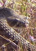
Hiked 11-12 miles Gonna mail food ahead to Colossal Cave. Saw another hiker outside wearing a Moenkopi shirt! He had a sexy Aussie accent and told us about his 21 day private trip, his backpack was massive. Jamie thinks I want to see him again just to hear his voice, he's not wrong. Found an old toilet in the forest. Saw two cow calfs nursing,the black baby cow stopped to look at us and had a big white milk mustache! So adorable.


March 8, 2019
Day 8
Hiked 10.8 miles Cloudy day so much wind almost zero sun hitting us all day. Water flowing great in garden Cyn creek. Lots to drink!! Fell asleep within 30mins of setting up tent.


March 9, 2019
Day 9
Hiked 15.5 miles
Brrrrr. Birds making every sound imaginable when sun hit tree tops. Nice waking up to such innocent wildlife again.
Ran into “Two Step” he was SoBo section told us there's food at Kentucky Camp. “Warden” passed us while we breaked a mile from KC said his knee was bum so he's taking it easy. Nice guy from Alaska. Met Matt B. (Shin splints guy) at Kentucky Camp, shared salami with him hiked a while with TikTok(m), Cookie and Cashmere (f & f) a badass trio.
Will is gonna meet us at Twin Tanks and Emily Hansen is gonna ride by and say hi (she also brought me some injinji toe socks!)
Gorgeous views of rolling hills today decent wind but not too bad. Sunset was spectacular!
Tonight the northern horizon glows a soft salmon pinkish orange like a sunset 3 hours late.
I got up to pee and was struck by the darkness of the night sky above me. Every star imaginable seems out tonight. The gentle glow of Tucson to the north stopped just low enough to allow the stars to POP on their own. The entire 360° view from camp tonight is like some sort of long exposure photo from sunrise to darkness and star light. I've tried to describe it best I can with words but only having stood beside me and having seen it with your own eyes would make you understand. It was beautiful.


March 10, 2019
Day 10
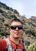
Hiked 14 miles. Camped at Twin Tanks azt mile 100. 10mi a day average feels good and comfortable. Had some longer days with easier terrain and shorter days with exhausting uphill and snow. Met “One Step” he's from Maine. Met “Ridge Route”(m) and “Shortcut”(f) from San Diego. Will found us about 2 miles from Twin Tanks! He brought fried chicken haha Will is awesome and super glad to have him along! His trailname is Ullward (Ullward and upward! I would yell every day we were together)
“One step” and another guy are camped nearby. Lots of cows.


March 11,2019
Day 11
Hike 6mi to Sahuarita hwy83 jct.
Arch hurts. Met “Cake” (m), “Warden”, and Shin Splints Matt showed up too. Emily Hansen is gonna come find us when she finishes her bike ride and drive us somewhere. Wonder how many ppl we can fit in her truck haha
Cake said he has two friends who are gonna work at the North Rim, John and Ellen. Can't wait to meet them. Trying to convince him to come up too haha Met “Rainbow Dash”(f) at Trailhead here she's hitching up to Tucson too.
Staying at fancy schmancy Omni Resort in Tucson with Will (he's amazing! I really enjoy hanging with him I hope he knows that), Emily Hansen joined us too. Zero day tomorrow thank goodness, my left arch is really hurting me. It's swollen and flat, like the arch collapsed or something. After 100 miles I'd collapse too...lol Emily is my hero. I cannot thank her enough for her kindness and support.
Shin Splints Matt crawled into the BearBox at Sahuarita JCT and I laughingly called him "Bear Box", that's his trailname now.
After we met "Rainbow Dash" someone mentioned thinking her name was Lightning Princess, shortly thereafter BearBox gave me my trailname of "Lightning Princess".

((Note BearBox had to pull off trail later on north, he took the summer off then returned to finish the AZT NoBo, he caught up with Jamie and I while we were working on the North Rim and attended our annual Halloween party up there. Cool reunion))


March 13, 2019
Day 13
Hiked 6.4 miles to Cienega Creek, camp below beautiful cottonwood atAZT mile 113.1
Great water source. Right next to railroad tracks.
Annette Feagans dropped us of at trailhead 1pm!!
“Stump” and “Mandolin” were dropped at same time.
Made it to the snake tunnel shortly and met “Worm” aka Mike. We saw him in Kentucky camp earlier too. Got some great photos of Ullward (Will). He's so fun to hike with. Went a few miles further to creek setup camp early at 4:30, today is a great day for my foot so took it easy. New inserts doing good so far. “Golden” showed up in Cienega Creek just now, he's gonna camp by us cool! He said he's shooting for Oracle by Monday wow! Big days ahead. He's not a fan of snow on the mtns either. We'll see.


March 14
Day 14
Hiked 13.3 miles to camp in Rincon creek at azt mile 126.3
Camping with Bluebird & Tiny Dancer, Mandolin & Stump. Good group!
Met Good Name/Ole Gramps(?) At Colossal Cave. I took a 45 min tour with Guide Savannah it was $18 and tax. I had margaritas...i want to then give the whole trail and report back on every margarita that is accessible from the trail. Camped at Rincon creek with Tiny Dancer, Bluebird, Mandolin and Stump.


March 15,2019
Day 15
Hiked 9 miles. Camp at Grass Shack Campground at azt mile 135.3
Left foot hurts so bad I was having dreams about walking and falling and rolling my ankle. Absolutely ridiculous. Contemplating getting off trail for a few days and bunking up in Oracle somehow...managed to.hike to.grass shack really well. Right around 9 miles foot starts swelling and really hurting. Limped into camp, very beautiful camp. Will was happy to stop too,that was a haul up and it got chilly fast. Tent pitched, I nooked up and dove into a book faster than necessary. Also ate too much and threw up in the toilet up trail...oops.


March 16
Day 16
Hiked 8.9 miles, camp outside Saguaro NP boundary at amazing overlook at AZT mile 144.2
Met “Snow” (f) she mentioned something cookie shop in Summerhaven. Must get Choco chip cookies! She is traveling is with “Barrel”(m). They passed us and moseyed on down trail at a charge.
First 2 miles up to Manning from Grass Shack was okay last 2 to Manning destroyed my foot SO much pain.
Another two to summit then two down to NP boundary and just beyond to awesome campsite. It's tight fit snug for two tents but whatever we're all friends here.


March 17
Day 17
Hiked 8 miles to Redington Pass.
Really struggling with left foot. Emptied water from pack to lighten load. Ate as much food as possible this morning to lighten load. Foot has CBD balm on it, wrapped, no blisters, downhill for 8 miles which you'd think would be a blessing but any weight at all causes agony to the left foot. Can I just chopped it off and clone my right foot?


As of March 17 I hiked 152 miles of the AZ Trail before I jury caused me to leave trail. I spent the rest of March, April and May babying the left foot. It was not until July 2019 that the foot could handle miles and weight again. Unfortunately by then i was working full time at Glen Canyon NRA for the National Park Service and it was as hot as Phoenix up there and I worked all sorts of crazy hours.

I'm editing his log in early November, that left foot of mine is much better and ready to get back at it. Let's hope it stays in shape while I train it with a pack this winter.


Jamie and I spent the next week with Will (Ullward) and I spiraled into a post-hike/failed attempt depression. I'm sure I wasn't very fun to be around though I tried to stay positive.
We traveled southern AZ from the Chiricahuas to Picacho to Tombstone then found ourselves in Kanab, Utah to retrieve our vehicle and belongings thanks to Will. He's a wonderful Friend and I'm happy to have spent the time we did together and hope we all get together again soon.


_____________________
Canyon Freak Adventures!
  3 archives
average hiking speed 2.41 mph
1, 2, 3, 4  Next

WARNING! Hiking and outdoor related sports can be dangerous. Be responsible and prepare for the trip. Study the area you are entering and plan accordingly. Dress for the current and unexpected weather changes. Take plenty of water. Never go alone. Make an itinerary with your plan(s), route(s), destination(s) and expected return time. Give your itinerary to trusted family and/or friends.

helpcommentissue

end of page marker