|
| | | |
| |
|
| Snowshoeing | 4.69 Miles |
235 AEG |
| | Snowshoeing | 4.69 Miles | 3 Hrs 51 Mns | | 1.83 mph |
| 235 ft AEG | | | | |
|
|
| |
| Partners |
|
none
[ show ]
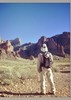
| no partners | | After burning through whatever energy my legs had by breaking trail Saturday, I opted to head for the Rim Lakes area on Sunday. I was going under the assumption that somebody would have been up there and run FR300 in a snowmobile, packing down a track for easier snowshoeing along the rim. As it turned out, nobody had been there.
But a couple minutes after arriving, a big toy hauler pulled in after driving up from Chandler. He had three snowmobiles and was going to head out, so I thanked him and informed him that I'd be following in his tracks. While impatiently waiting for them to get their stuff together, I might've had it out with some idiot camping in the parking lot who seemed to think that blasting Christmas music across the forest was normal/acceptable/reasonable/seasonal?
Anyway, snowshoeing was pleasant in the tracks, but my thought of going all the way to Woods Canyon Lake was quickly put to rest, and we swung out toward the rim near military sinkhole to enjoy the solitude and views.
On the return, the Rim Lakes parking area was an absolute pooeyshow of people and I couldn't get away from it soon enough. The drive home was no less entertaining, with the Beeline highway littered with people who have never seen snow before, or somehow thought that parking on a 65mph highway shoulder was a good idea. Or sledding into it.
I felt bad for the kids whose parents brought them to the area between four peaks and sycamore creek to go sledding. It must be awful to be sliding on snow through catclaw bushes, only to come to a complete stop in a prickly pear!
There was a virtual parking lot of instagram photographers capturing the elusive shot of the four peaks with snow on them. From the highway. Because, yay. I wonder if this is the real reason why people from colder climates hate winter so much? It's not actually the snow, it's the people! It freezes their brains!  |
| _____________________
| I'm not sure what my spirit animal is, but I'm confident it has rabies. |
| | |
|
|
|
 Route Editor