|
| | | AZT: Mormon Lake to Utah, AZ | | | |
|
|
AZT: Mormon Lake to Utah, AZ
| | |
| |
|
| Backpack | 260.25 Miles |
25,126 AEG |
| | Backpack | 260.25 Miles | 17 Days | | |
| 25,126 ft AEG | | | | |
|
|
| |
| Partners |
|
none
[ show ]
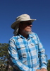
| no partners | | I'm not even sure how to approach a triplog of this magnitude, so I'll try to keep it short and focus on the highlights/lowlights.
The hike took place between May 31st and June 16th. We had 2 zero days (one in Flagstaff, one in Tusayan), and one "nero" out of Tusayan. We averaged 25 - 30 miles a day, except for in the Grand Canyon. This trip started out with a few hiccups (feet, gear, fires, heat...) but after Tusayan we had the kinks worked out and I felt like a well oiled long distance hiking machine.
Hightlights
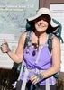
Humphrey's Summit Side Trip
We decided to include a side trip to Humphrey's Peak. It was a great way to escape the hottest part of the first weekend and let things cool down below 9000ft, even if the summit was swarming with gnats and people.  On the way back down, I met @joebartels and @the_eagle. Very cool! Nice to have met you both! On the way back down, I met @joebartels and @the_eagle. Very cool! Nice to have met you both!
Grand Canyon
The Grand Canyon Rim-to-Rim was AMAZING. The scenery had my jaw on the ground nearly the entire time! I was extremely nervous about doing this passage in June and thought it was nearly impossible to score walk-in permits, but the stars aligned and we had no issues grabbing permits for both campgrounds.
We did it over 3 days to beat the heat, camping at Bright Angel and Cottonwood campgrounds, moving only between the hours of 5am - 9am. Soaking in Bright Angel Creek made the heat tolerable, and it was a nice change of pace compared to the 25 - 30 mile days we were doing above the rims.
One of the rangers issuing the permits gave us some dire warnings about "130 degrees in the sun", and how "nobody has fun down there this time of year." I even asked him about soaking in the creek to ward off the heat and he made it sound like it was only mildly effective. Contrary to what he said, it probably never got above 105 in the sun and sitting in the creek was actually extremely relaxing.
We took the short side trip to Ribbon Falls and it was totally worth it. What a neat little oasis in the canyon! We saw a beaver in the creek between Bright Angel and Cottonwood campgrounds, I never expected to see that.
The climb out of the Canyon from Cottonwood to the North Rim was well graded, and we topped out in about 2 hours 45 mins.
There is definitely a lot more Grand Canyon hiking in my future come fall/winter/spring.
North Rim + Kaibab Plateau
It was so nice to get a break from the hot temperatures when we topped out on the North Rim. They didn't last for long, though. As soon as we were back down around 7000 ft it was getting warm again.
The aspen and fir lined meadows were also a nice change of scenery. Easy going, dreamy hiking. It was also cool starting the day at Cottonwood and within a few hours being in a drastically different environment.
We ran out of food just before highway 89A, so we went in to Jacob Lake for a small resupply and also had a great breakfast at the restaurant. We probably had less than 2000 calories per day from the North Rim to Jacob Lake, needless to say the hiker hunger was strong when we reached Jacob Lake.
Finishing the AZT
Damn did it feel good.
Lowlights
Feet Issues
On day one I had a nasty blister form on the bottom of my foot due to AZ rocks tearing up the tread on my one month old Altra shoes. When we reached Flagstaff I initially tried to remedy the problem by buying thicker insoles (SuperFeet) for my shoes and taping up my foot with climbing tape. I was apprehensive about getting new shoes because I've always had issues with breaking in new shoes, even trail runners. The tape and thicker insoles worked for about half of a day. I think the tape actually might have made matters worse. I decided the next day after leaving Flag to hitch back into town from Snowbowl Rd in order to pop the blister and let it heal with a zero day. We got a ride by the first vehicle that I thumbed!
Popping the blister and staying off of it for a day helped, but after our Humphrey Summit and a couple more days of hiking the blister was back with a vengeance by the time we reached the Babbit Ranch passage. I was very nervous about going forward from Babbit Ranch because it would mean committing to about 60 miles before any relief in Tusayan. I nearly walked out to the highway from the TH and called for pickup. But after sleeping on it, I sucked it up and continued. Eventually, after hiking on it for another 40 miles, it stopped hurting so much.
When we reached Tusayan I decided to bite the bullet and take a shuttle back to Flagstaff to get some new shoes. I bought some Brooks Cascadia 11's, swapped out the insoles with the SuperFeet I bought, and never had a single foot issue the rest of the trip.
Gear Issues
Sleeping pad got punctured and I lost my sunglasses the very first night. These items were replaced on the first visit to REI in Flag. Somewhere along the way, the "stay bar" in my backpack ripped through the bottom of my pack again and went missing.
Fires
The nearby fires on the rim made the miles into Flagstaff smokey. It was particularly bad on the second day when we woke up at the Horse Mesa Trailhead with thick smoke to hike through til Marshall Lake. Those were some lightheaded, oxygen deprived miles.
Heat
When I planned this trip, I expected the highs to be in the high 70s to low 80s, actual highs were in the high 80s to low 90s for the entire trip, expect for the North Rim and Kaibab Plateau South & Central passages. As expected, it reached low triple digits in the Grand Canyon. We combated the heat by taking a long 2 hour break during the hottest part of the day under a cedar or pine. If there was a good enough breeze, usually we could still hike in the heat. We were also consuming up to 2 gallons of water a day.
Final AZT Thoughts
In my opinion, the Grand Canyon takes the cake for the most scenic passage of the trail. That being said, I believe that below the Mogollon Rim the AZT is way more scenic per-mile than on top of the plateau. It's easy to keep motivated below the Rim when you're getting drowned in gorgeous wide open views in every direction, and hard to keep motivated above the Rim when all you're seeing most of the day is the next ponderosa or ceder 10 yards ahead of you. Just my opinion, though.
AZ rocks with eat up your shoes.
If I was to ever attempt a thru-hike of the trail, I would most likely start in the early fall and head south. The terminus in Utah isn't a terrible place to end, but Miller Peak and Mexico would have been a much grander ending. |
| _____________________
| | |
|
|
|
 Route Editor


 )
)
 . I knew I must have left it somewhere during a break but couldn't remember where. It was too late to turn back as I would need to make camp soon but didn't have a permit to stay in the park (my plan was to stay at the NR hiker's campground which usually has spots). I continued on to the campground and spent a near sleepless night racking my brain as to where the inReach could be. My coughing and gas-passing neighbor (the campsites are very close together) didn't help much. About 33 miles for the day.


