username
X
password
register
for free!
help
ArticlesGuidesRoutes
 
Photosets
 
 Comments
triplogs   photosets   labels comments more
Ballantine Trail #283 - 24 members in 100 triplogs have rated this an average 3 ( 1 to 5 best )
1, 2, 3, 4, 5  Next
100 triplogs
login for filter options
Apr 27 2025
avatar

 Guides 44
 Routes 162
 Photos 24,766
 Triplogs 2,411

75 male
 Joined May 04 2004
 Mesa, AZ
Ballantine Trail #283Phoenix, AZ
Phoenix, AZ
Hiking avatar Apr 27 2025
CannondaleKidTriplogs 2,411
Hiking7.40 Miles 1,759 AEG
Hiking7.40 Miles   3 Hrs   55 Mns   1.97 mph
1,759 ft AEG      10 Mns Break18 LBS Pack
 no routes
1st trip
Linked   linked  
Partners partners
trixiec
We hadn't hiked this to our usual lunch spot near Boulder Flat since late November 2022 so we were due for a repeat to see if/how much it has recovered since the last fire.

We began with the long climb up Trail #280 to get that out-of-the-way, following #283 around the mountain on the return trip.

My memory seems to be a bit foggy on this (yep, that old age thing) as I simply did not remember this many ups-and-downs... every time I thought we'd completed the last climb another one popped up. But no matter, with no pain to speak of, today was one of the good days. Even though the only breaks were to let Tracey catch up due to taking so many flower photos, I never felt out-of-breath or overly stressing either hips or knees on the steep rocky and many times loose ascents/descents. But then again, we barely hit 3,000' as opposed to the 6-7K elevations we had in the Chiricahuas.

We could not have asked for a better day for a hike, with the temp ranging from 64° to 70° along with gusty winds to keep from feeling too warm in the direct sun.

HR Avg/Max = 101/145

FYI: No, Tracey was not running back and forth constantly taking photos to rack up 10 miles, or the 3K+ AEG, she just used the default stats for the whole Ballantine Trail.
_____________________
CannondaleKid
 
Apr 27 2025
avatar

 Routes 1
 Photos 264
 Triplogs 22

69 female
 Joined Jun 12 2010
 mesa,az
Ballantine Trail #283Phoenix, AZ
Phoenix, AZ
Hiking avatar Apr 27 2025
trixiecTriplogs 22
Hiking10.00 Miles 3,484 AEG
Hiking10.00 Miles
3,484 ft AEG
 no routes
1st trip
Linked   none no linked trail guides
Partners none no partners
While this trail isn't a favorite since the fires, we figured it was close by and we'd see how the landscape had changed in the past few years. Trail hadn't changed, but I don't recall ever seeing such a variety of wildflowers in the past. So my goal was to document each one. I may have missed a few, don't know the names of several, some photos are blurred as my camera had a difficult time focusing... kind of like me some days. It ended up being a beautiful hike.
_____________________
 
Jan 18 2025
avatar

 Guides 12
 Routes 192
 Photos 863
 Triplogs 356

42 male
 Joined Nov 30 2015
 Phoenix, AZ
Ballantine Cabin & CorralPhoenix, AZ
Phoenix, AZ
Run/Jog avatar Jan 18 2025
ShatteredArmTriplogs 356
Run/Jog8.35 Miles 2,205 AEG
Run/Jog8.35 Miles   3 Hrs   9 Mns   2.74 mph
2,205 ft AEG      6 Mns Break
 no routesno photosets
1st trip
Partners none no partners
Decided to head back the Ballantine area after a long absence, with the goal of getting to the cabin, and a stretch goal of doing the boulders loop. Turns out I'm really out of shape, because I was feeling pretty tired by the time I got to Boulder Flat, and figured there's no way I'd actually do the boulders. The fire hit some of the lower parts of the trail pretty hard, but it also did a pretty good job clearing away some of the thornier vegetation.

The catclaw got pretty bad right before the cabin - which it turns out had burned down in on of the recent fires. Bummer, I never got to see it! Poked around for a few minutes, then started back.

On the way down, I actually saw a group of a few hikers. That's a first for me on Ballantine Trail.
_____________________
  1 archive
Nov 10 2024
avatar

 Guides 59
 Routes 1,100
 Photos 1,191
 Triplogs 1,290

male
 Joined Jan 01 2023
 Arizona
Boulder Mountain / Whorled WallPhoenix, AZ
Phoenix, AZ
Climbing avatar Nov 10 2024
pseudalpineTriplogs 1,290
Climbing14.72 Miles 4,732 AEG
Climbing14.72 Miles   8 Hrs   4 Mns   2.19 mph
4,732 ft AEG
 
••• Dk Drag Solo 4thTrad
Route Scout Route Recorded  on Route Scout | Pop | Map | Popup | MapDEX
You'll need to work for this summit, which is one of the best in the Mazzies, hands down. It isn't boring Ord, it's more difficult than both Catherine and Peeley. Not sure about Mazatzal Peak yet, as I'll hold my opinion until sometime next week. And there's no silly register at the top. Just Ladybugs and one giant bear turd. :-k The Pine Creek Loop and lower Ballantine Trails are 90% burnt. It'll be decades before this area returns to what it once was. The Pipeline Trail is becoming more obscure but still there's evidence of some badass fat tire motorcyclist utilizing it. No water anywhere, but that was expected this time of year. Just right of A-Frame (east of the southern prow) of Whorled Wall is the most direct route to the summit. It's loose in the first third but surprisingly solid through the upper two thirds. There's a huge dead Agave stalk marking the top out. Yeah, it'll eventually fall over but there are several more Agaves growing in the same place that may continue to mark the route.
  15 archives
Jun 15 2024
avatar

 Guides 27
 Routes 669
 Photos 12,096
 Triplogs 856

56 male
 Joined Jul 05 2006
 Mesa, AZ
Ballantine to Boulder FlatPhoenix, AZ
Phoenix, AZ
Hiking avatar Jun 15 2024
DarthStillerTriplogs 856
Hiking9.97 Miles 2,206 AEG
Hiking9.97 Miles   6 Hrs   30 Mns   1.62 mph
2,206 ft AEG      20 Mns Break
 
Partners none no partners
Went in 5 miles and turned around. I almost hiked this 2 weeks ago and I'm very glad I didn't due to the fire. 5 miles in it looked like the burn ended there but at my turnaround point it was still burnt at the trial. The last quarter mile before I turned around I lost the trail due to the burn. I could see further up where I stopped where the trail went. Past Boulder Flat the trail was much fainter and harder to follow.

The heat wasn't too bad, but I'm still very slow going uphill, even with moderate warmth. Once I stopped for lunch, it wasn't hot at all. By the time I got back to the car it was hot, but I was going downhill.

Saw a desert tortoise halfway up. He was dusty but still seemed healthy and moved pretty well. Interesting to see how this area looks so recently after a burn. It also seemed like the safest area to hike with the recent wildfires around and still get some elevation gain with a bit of relief from the lower valley heat.
 Fauna
 Fauna [ checklist ]
[ checklist ]  Desert Tortoise
_____________________
 
Apr 07 2024
avatar

 Routes 255
 Photos 8
 Triplogs 261

54 male
 Joined Feb 19 2015
 Phoenix
Ballantine Trail #283Phoenix, AZ
Phoenix, AZ
Hiking avatar Apr 07 2024
bjonsonTriplogs 261
Hiking10.12 Miles 2,241 AEG
Hiking10.12 Miles   4 Hrs   37 Mns   2.27 mph
2,241 ft AEG      9 Mns Break
 
no photosets
1st trip
Partners none no partners
Route Scout Route Recorded  on Route Scout | Pop | Map | Popup | MapDEX

water 1 out of 5water 2 out of 5water 3 out of 5water less than max Camp Creek Medium flow Medium flow

water 1 out of 5water 2 out of 5water 3 out of 5water less than max Camp Creek Spring Gallon per minute Gallon per minute

water 1 out of 5water 2 out of 5water 3 out of 5water less than max Pine Creek Medium flow Medium flow
_____________________
 
Mar 27 2023
avatar

 Guides 8
 Routes 70
 Photos 3,208
 Triplogs 273

59 male
 Joined Oct 07 2017
 Chandler, AZ
Pine Creek Loop #280Phoenix, AZ
Phoenix, AZ
Hiking avatar Mar 27 2023
YoderTriplogs 273
Hiking8.60 Miles 2,300 AEG
Hiking8.60 Miles   3 Hrs   59 Mns   2.42 mph
2,300 ft AEG      26 Mns Break10 LBS Pack
 no routes
1st trip
Linked   linked  
Partners none no partners
We decided to do the Pine Creek Loop (#280) along with some of the Ballantine Trail #283. Were the Ballantine drops south, we decided to follow the trail North up on for a bit. After going up the side of the mountain (about 200ft elevation gain), it drops back down into a valley and meets up with what is titled the Pipeline Trail on the map application I have. The Pipeline Trail appears to be more of a road. Walked up it a little and turned back.
 Fauna
 Fauna [ checklist ]
[ checklist ]  Turkey Vulture
wildflower observationwildflower observationwildflower observationwildflower observationwildflower observation
Wildflowers Observation Light
_____________________
J. Yoder
 
Feb 18 2023
avatar

 Guides 59
 Routes 1,100
 Photos 1,191
 Triplogs 1,290

male
 Joined Jan 01 2023
 Arizona
Ballantine to Boulder FlatPhoenix, AZ
Phoenix, AZ
Hiking avatar Feb 18 2023
pseudalpineTriplogs 1,290
Hiking7.14 Miles 1,634 AEG
Hiking7.14 Miles   2 Hrs   54 Mns   2.64 mph
1,634 ft AEG      12 Mns Break
 
no photosets
Partners none no partners
Route Scout Route Recorded  on Route Scout | Pop | Map | Popup | MapDEX
Trail is overgrowing again (slightly). Still too early for wildflowers.
  3 archives
Jan 21 2023
avatar

 Guides 1
 Routes 14
 Photos 7,202
 Triplogs 5,208

68 male
 Joined Mar 16 2008
 chandler,az
Ballantine Cabin & CorralPhoenix, AZ
Phoenix, AZ
Hiking avatar Jan 21 2023
johnlpTriplogs 5,208
Hiking11.47 Miles 2,693 AEG
Hiking11.47 Miles   4 Hrs   45 Mns   2.69 mph
2,693 ft AEG      29 Mns Break
 no routes
Partners partners
trekkin_gecko
Kelly suggested hiking Ballentine to the cabin, and maybe adding on some extra with the Pipeline trail.
We got started to chilly temps, with some frost and ice in places. Once we got to the cabin it was nice and warm.
We hiked down to Pine Creek on a motorcycle trail instead of Pipeline. The creek was flowing good. Very scenic. In fact, the whole hike is scenic. Mountains, boulders, saguaros, and lots of running water.
Good day. Thanks Kelly. :)
 Named place
 Named place [ checklist ]
[ checklist ]  The Boulders
wildflower observationwildflower observationwildflower observationwildflower observationwildflower observation
Wildflowers Observation Isolated
_____________________
“Good people drink good beer.” Hunter S Thompson
 
Jan 21 2023
avatar

 Guides 10
 Routes 673
 Photos 7,281
 Triplogs 4,660

67 female
 Joined Nov 17 2008
 phoenix, az
Ballantine Cabin & CorralPhoenix, AZ
Phoenix, AZ
Hiking avatar Jan 21 2023
trekkin_geckoTriplogs 4,660
Hiking11.47 Miles 2,611 AEG
Hiking11.47 Miles   4 Hrs   45 Mns   2.69 mph
2,611 ft AEG      29 Mns Break
 
Partners partners
johnlp
hit john up to hike ballantine trail to the cabin
hadn't been on this hike in nine years
we got going around 0700 or so
chilly temps, but fine going uphill
took the southern piece of pine creek loop, then ballantine to boulder flat
up and over the ridge toward the cabin
we had planned to add some mileage on pipeline trail but ended up on a motorcycle? trail that went northwest to pine creek
we turned around there since we didn't see any way to stay dry crossing the creek
took a little break at the cabin on the return
makes for a nice destination
back through the scenic boulder terrain, finishing on the other half of pine creek loop
i like this hike although i find some of the footing challenging
thanks for hiking and for driving john - good times :)
it's been fun revisiting some hikes i haven't done in a few years
_____________________
hazhole
 
Jan 19 2023
avatar

 Guides 1
 Routes 23
 Photos 579
 Triplogs 45

male
 Joined Jan 10 2014
 Fountain Hills,
Ballantine Cabin Lasso Loop, AZ 
Ballantine Cabin Lasso Loop, AZ
 
Hiking avatar Jan 19 2023
GeeEssTriplogs 45
Hiking8.00 Miles 2,195 AEG
Hiking8.00 Miles   4 Hrs   45 Mns   1.68 mph
2,195 ft AEG
 
1st trip
Partners none no partners
Just wanted a bit of a workout today without getting too cold or driving too far, and this seemed to fit the bill. Nice flat parking area immediately off of SR 87, so easily accessible to all, and a reasonably well-maintained trail nearly all the way to the cabin. All in all, a bigger workout than I was expecting, and more time consuming as well, largely due to the uphill portions of the trail. Plenty of cactus and great views on the way up, and plenty of running water. Agaves and Dudleya are found in fair quantities near the cabin.
_____________________
 
Dec 07 2022
avatar

 Routes 154
 Photos 1,505
 Triplogs 266

31 male
 Joined Jun 02 2019
 Phoenix, AZ
Boulder Mountain, AZ 
Boulder Mountain, AZ
 
Hiking avatar Dec 07 2022
LJWTriplogs 266
Hiking24.63 Miles 5,300 AEG
Hiking24.63 Miles   11 Hrs   43 Mns   2.41 mph
5,300 ft AEG   1 Hour   30 Mns Break
 
Route Scout Route Recorded  on Route Scout | Pop | Map | Popup | MapDEX
Early end to 2022, and for my customary Mazzy year-ender I went back to Boulder. Started the year by looping Pine Mountain, so there was some poetry in ending by looping its little brother. Followed in the 2014 footsteps of @BiFrost and sent their route to RS. Timed right, this route is one of the best ways to spend a day in Central AZ. Jumped on this one as the cold front finished up. Went CCW an hour and a half before sunrise.

Wrote about this in January, but Ballantine is largely no good past the corral. So it was creek bed until the climb out, where the trail picks up until the ridge. After that, got off track before Rock Tank. Gets easier to follow after as the trail heads into the pines toward the AZT connector.

The very top of the connector is gone, so I headed straight up to the road. There's a barbed wire fence the way I went, but it seemed easier than the alternatives. Clouds passed overhead and storms built to the west as I walked the road. Decided if the ridgeline wasn't covered in clouds by the time I got there, there was no way I would turn back. The sky was cloudy and darkening over everywhere but Boulder, so I took it as a sign and headed up the ridge.

It's a bushwhack around the boulders until the first saddle. Then the route enters the Bush Fire perimeter. The only burned pines are around the first saddle. The mountainside is a nice and easy walk under the green, green pines until the third saddle, where in years prior to 2020 the route became a significant bushwhack. Maybe the only good thing to come out of that fire is that the brushy sections of the Boulder Mountain ridgeline mostly burned. It was almost disappointingly easy. Still tough so many miles in. There's one notable scramble before the final climb to the summit. Other than that the terrain wasn't too bad, mostly piney or burned away.

Made the summit, and like in 2019 I only go to enjoy it for about a half hour before the rain clouds started to roll in. By the time I made Pipeline, the mountain and ridgeline were swallowed up. Took a break at the cabin, and proceeded to Ballantine and down. Awesome cloudy sunset made for a great finish.

water 1 out of 5water 2 out of 5water less than maxwater less than max Ballantine Canyon Light flow Light flow

water 1 out of 5water 2 out of 5water 3 out of 5water 4 out of 5 Rock Tank 76-100% full 76-100% full
Medium-light flow

  7 archives
Apr 30 2022
avatar

 Guides 25
 Routes 376
 Photos 5,897
 Triplogs 346

40 male
 Joined Mar 01 2018
 Chandler, AZ
Ballantine Cabin to Boulders LoopPhoenix, AZ
Phoenix, AZ
Hiking avatar Apr 30 2022
John10sTriplogs 346
Hiking17.46 Miles 3,533 AEG
Hiking17.46 Miles   12 Hrs   23 Mns   1.76 mph
3,533 ft AEG   2 Hrs   29 Mns Break
 
1st trip
Partners partners
TboneKathy
Route Scout Route Recorded  on Route Scout | Pop | Map | Popup | MapDEX
I'd passed the Ballantine Trailhead along Highway 87 many times without knowing much about what the trails had to offer, and we decided to give it a try today. The trailhead itself is fairly nondescript, but the geology to the east is fantastic. There were two other cars in the lot, and we were on the trail before 7AM.

There's a lot of highway noise along the first stretch heading north, but that fades as the trail turns to the east ~3/4 of a mile in. It's a steady climb from the beginning...not overly steep, but not many breaks from the consistent uphill. The boulder piles, balancing rocks, and windows are very impressive, with geology reminiscent of Wonderland of Rocks in Joshua Tree. I couldn't help but leave the trail once or twice to scramble around on some of the interesting formations.

Ballantine Cabin is about four miles in, and we were able to avoid the worst of the catclaw surrounding the cabin, so the approach wasn't too bad. The cabin is in pretty good shape aside from some open spots in the roof and the typical Arizona bullet holes. There's a picnic table inside and the usual collection of random food items that seem to get left behind in most of the old cabins. As we continued east, I found a random pot sherd along the trail, and that continued throughout the day...in total, I found close to 10 pieces at various points along the route.

The steady uphill climb continued along the loop, and the trail was easy to follow the vast majority of the way, though there were quite a few steeper sections with loose gravel. catclaw was common but not so thick that we couldn't go around the worst of it. The geology continued to impress throughout the loop. That was the good part...

The not so good part: it ended up being a slower, more "interesting" hike than anticipated. Around seven miles in, TboneKathy started feeling weak and lightheaded, so our pace slowed considerably and we took frequent breaks, especially on the steeper uphill stretches. We still had a lot of miles to cover, and I was concerned that if she didn't start feeling better, we could be headed for a rescue situation. Cell reception was probably out of the question that far out, and there were too many miles to cover to carry her all the way to the trailhead. We had plenty of food and water, and it wasn't especially hot, which helped.

We made slow progress around the loop, and during one of her breaks, I took a short detour off the trail to check out a stone corral. In places, the big rectangular enclosure looked a lot like native ruin walls. It's certainly more modern, though I did find a few pot sherds in the middle, which made me wonder. A little further along the southern portion of the loop, we passed two other small walls of stacked rock...they were too small to be corrals or dwellings, so I'm not sure what purpose they served.

We finally made it back to Ballantine Cabin, and TboneKathy did well pushing through the last four miles to make it out before dark despite not feeling well. It was a beautiful area, but the situation was concerning, and I spent much of the hike very thirsty, conserving a lot of my water in case I needed to leave some behind with TboneKathy to go get help.

Fortunately, it turned out okay...just a longer day and a more uncomfortable hike than expected, but it could have been a lot worse. We didn't see anyone on the trails all day, and there were a lot of wildflowers blooming in different colors throughout the route. Wildlife included some toads, a horned lizard, a deer, a light-colored snake, and plenty of birds. Seeing the cabin and the bonus pot sherds was interesting, and the benefit of the late finish was seeing the sunset on the drive home.
wildflower observationwildflower observationwildflower observationwildflower observationwildflower observation
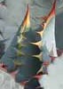
Wildflowers Observation Substantial
Blooming cacti, globemallows, Mariposa lilies, and many more that I couldn't identify :)

water 1 out of 5water less than maxwater less than maxwater less than max Upper Pine Creek & Tributaries Pools to trickle Pools to trickle
water report recorded in the field on our app Route Scout
 
Feb 26 2022
avatar

 Guides 27
 Routes 669
 Photos 12,096
 Triplogs 856

56 male
 Joined Jul 05 2006
 Mesa, AZ
Ballantine to Boulder FlatPhoenix, AZ
Phoenix, AZ
Hiking avatar Feb 26 2022
DarthStillerTriplogs 856
Hiking10.72 Miles 2,087 AEG
Hiking10.72 Miles   5 Hrs   17 Mns   2.04 mph
2,087 ft AEG      2 Mns Break
 
Partners partners
joebartels
The_Eagle
Midweek I was leaning towards hiking South Mountain since I haven't been there in a while. Then on Thursday after the clouds cleared from the previous day's rain, it revealed snow on Four Peaks and the ridgeline north of it. I knew I wanted to go up there. I looked over the HAZ map for planning and on the satellite photos I saw a singletrack from the cabin north of Boulder Flat head northwest down to FR1704. I traced it out with a track until I lost it, then I saw it was already traced out on OpenTopo. OpenTopo also showed another singletrack loop east of the cabin, but that looked quite a bit longer.

I was the first one at the Ballantine TH and headed up just as no headlamp was needed. About a half mile up I looked down and saw another car pulling in. Around the 2.5 to 3 mile mark, I heard someone make a calling noise. I turned to look and no one was visible. I turned around again and the exact same call was made. Still not visible. Someone was messing around. I turned and started walking again. The trail took a turn and I had an opportunity to go off trail and up a hill to see who it was before they knew I was off trail. Instead I turned around again since I hadn't heard a 3rd call and the hikers showed themselves. Soon enough I was able to see it was Joe and Bruce, which I kind of suspect it might be.

"Are you guys doing the 32 mile loop today?"
"What? Oh. No, just 18."
"Ah."

Bruce had also discovered the loop east of the cabin and he and Joe were on a similar mission as me, but different trails, nearby. Funny how that worked out. They quickly left me for dead and we were on our separate ways.

I forgot how far it is up to Boulder Flat and how much work it is. I was thinking I might be able to knock out the entire unmarked trail and head back uphill to the cabin. I soon figured this would too much in a day. My plan was then to get to 5 miles and possibly turn around, making a respectable 10 mile hike. At the 5 mile mark, I had already descended close to 1000' from the highpoint saddle above the cabin. and the unmarked trail was very steep and loose in spots. Hiking the entire trail would put me at the 7.5-8 mile mark. I decided to do that and then hike the Beeline back to Ballantine. I wasn't really thrilled about hiking the Beeline, but I was less thrilled at hiking back uphill another 1000' and then making it down Ballantine, which would take time. I was also enjoying hiking a new trail I've never done and hiking downhill after a 2000'+ climb in 4 miles.

The unmarked trail is basically used and probably made by dirt bikers. The tire treads are visible pretty much the entire way. At the Pine Creek crossing I saw 3 dirt bikers who had stopped to rest by the stream. Some sections had a deep groove similar to that made on equestrian trails. Other spots were very rocky. I've been on worse trails, but this one obviously didn't have hikers in mind.

The views on the unmarked trail and Ballantine were amazing all day. Just enough snow at the high point of my hike to say I hiked in snow that morning, but didn't get my feet cold and wet. Temps were cool and breezy all day, making less of a need for water. Blue skies and clear air, perfect weather all around. Fun to see Joe and Bruce who had the same train of thought I did.
_____________________
 
Feb 26 2022
avatar

 Guides 41
 Routes 1,626
 Photos 14,983
 Triplogs 2,760

69 male
 Joined Jan 20 2009
 Far NE Phoenix,
Ballantine Boulder Loops, AZ 
Ballantine Boulder Loops, AZ
 
Hiking avatar Feb 26 2022
The_EagleTriplogs 2,760
Hiking20.22 Miles 3,849 AEG
Hiking20.22 Miles   10 Hrs   32 Mns   2.15 mph
3,849 ft AEG   1 Hour   7 Mns Break15 LBS Pack
 
no photosets
1st trip
Route Scout Route Recorded  on Route Scout | Pop | Map | Popup | MapDEX
The last time we were in the area 5 years ago, I noticed a very obvious track from the NE corner of our loop. When I got home, I traced out the loop using the satellite view. I had no idea how it would work out. It's been sitting in my files since then. With perfect weather forecasted, I through this out to a less than enthusiastic response.

We started at the Ballantine TH with one other car in the lot. That happened to be the Stiller mobile.

We ran into Chris at the 2.5 mile mark and hiked and chatted with him for a bit. He was on a different mission for the day, also on undocumented ground.

We made the turn off the Ballantine #283 on the unnamed western portion of the Ballantine Cabin Loop. We got off trail a bit following a wash and paid with our first blood letting of the day in thirsty virgin catclaw.

The Ballantine Cabin appears to have been cleaned up recently. Maybe in preparation for a VRBO guest?

We cashed some liquid and started our climb up the new (for us) trail. More than 80% of this trail is in great shape. I'm guessing the majority of the traffic on this loop are from motorcycles. But it does not see a lot of action. The nice part of the cycles going through there is that they leave a decent trail to follow and where there is catclaw, they've nicely removed a large portion of the claws from the catclaw.

Both loving the geology out there, we took way too many photos. There is a higher concentration of balanced rocks out there, than I've seen anywhere in the state. This loop adder really worked out quite well. Great views of Boulder Mountain to the north, snow covered Pine Mountain to the south and Red Mountain to the west and the other Red Mountain to the south.
YouTube -> [ youtube video ]

After finishing this new portion of the loop, we went up the western leg of the Ballantine Cabin Loop to make our way to the Ballantine Trail #283. This is the last time I'll try this one until it's been cleared. It was a total blood letting cluster chuck and is death by a thousand cuts.

The area around the corral on the Ballantine Trail looks totally different after the fire and subsequent flooding. The catclaw on the Ballantine down to where the western portion of the Ballantine Cabin Loop takes off, is also disappearing and prickly.

All said, I'd like to get out to this new loop portion again, but would defiantly bypass Upper Ballantine Trail and the eastern portion of the Ballantine Cabin Loop.

All washes were running on the day, perfect temps and Bluebird skies.
wildflower observationwildflower observationwildflower observationwildflower observationwildflower observation
Wildflowers Observation Light
Dichelostemma capitatum, Fairy Duster and a few poppies
_____________________
There is a very fine line between "hobby" and "mental illness."
Dave Barry 🦅
  2 archives
Feb 26 2022
avatar

 Guides 264
 Routes 2,797
 Photos 14,494
 Triplogs 5,894

55 male
 Joined Nov 20 1996
 
Ballantine Boulder Loops, AZ 
Ballantine Boulder Loops, AZ
 
Hiking avatar Feb 26 2022
joebartelsTriplogs 5,894
Hiking18.66 Miles 4,368 AEG
Hiking18.66 Miles   10 Hrs   31 Mns   2.01 mph
4,368 ft AEG   1 Hour   13 Mns Break
 
1st trip
Route Scout Route Recorded  on Route Scout | Pop | Map | Popup | MapDEX
We headed out clockwise on Pine Creek Loop #280. Just under four trillion Desert Hyacinth in the first couple of miles. Chris was hiking in the area by chance so that was the second highlight of the day.

Super pleasant hike until just before the cabin where Bruce decided to cross a field of catclaw. Continued up to the NE corner of the classic Ballantine Cabin & Corral. An annual or goto by several but I just find it okay.

Now into the heart ( loop part ) of Ballantine Cabin Boulders Loop we found ourselves pointing out balancing boulders and whatnot often. Patchy snow and recent moisture helped in areas I imagine are less easy to keep traction when dry. The primary users are motorcycles, so deeply grooved stretches on steep grades are part of the package deal. Like many trails in the Bradshaws, the bonus side of that deal is catclaw/brush maintenance by cycles plowing through it.

There was some bad catclaw on the return along a portion of Ballantine Trail #283 and the crossover to the cabin.

Synopsis
Bruce hemmed and hawed on this hike he drafted long ago. I twisted his arm and set him straight to give it a chance. Perfect weather for patchy snow. In rare fashion, I purposely traveled in the snow for traction. It was some of the best snowball snow I recall since I was probably 7 years old.
 Named place
 Named place [ checklist ]
[ checklist ]  Granite Mountain
wildflower observationwildflower observationwildflower observationwildflower observationwildflower observation
Wildflowers Observation Light
Substantial Fairy Duster and Desert Hyacinth along Loop #280

water 1 out of 5water 2 out of 5water less than maxwater less than max Upper Pine Creek & Tributaries Light flow Light flow
_____________________
- joe
 
Jan 11 2022
avatar

 Routes 154
 Photos 1,505
 Triplogs 266

31 male
 Joined Jun 02 2019
 Phoenix, AZ
Pine Mountain Loop, AZ 
Pine Mountain Loop, AZ
 
Hiking avatar Jan 11 2022
LJWTriplogs 266
Hiking19.50 Miles 4,500 AEG
Hiking19.50 Miles   8 Hrs   55 Mns   2.63 mph
4,500 ft AEG   1 Hour   30 Mns Break
 
1st trip
Route Scout Route Recorded  on Route Scout | Pop | Map | Popup | MapDEX
Finally got around to reaching Pine Mountain summit and completing the Ballantine Trail. Did it as a loop and checked off the rest of the 143 connector I hadn't done. Added in new ground east and south of Ballantine Cabin, and it ended up a day of new places in a familiar area, and my first trip back around since the Bush Fire.

Parked along the loop on 143 and started with the connector trail. It seemingly gets most of its traffic from dirt and mountain bikers heading to the cabin. For this it is easy to follow but eroded in the middle. Slippery with crushed granite. Clear water sliding over the sand in the many washes.

Over the ridge at Boulder Flat and to the Cabin. Went SE straight to the corral along the old ranching tracks. There are some cairns and the grade is there in places but it is a bushwhack with a healthy amount of catclaw. Breaked on a boulder and started the climb.

Ballantine Trail before the climb out of the Canyon to Rock Tank is almost entirely gone for the fire. Opted to stay in the mostly flat and sandy creek bed along the light flow of water. There was some quicksand, and I sank my leg in to my knee. It was fairly easy going and minimal bushwhacking. Where the trail still existed along/above the banks was obvious.

The trail for the climb out is in good shape, or at least it is easy to follow. The trail finds its way back to the creekbed shortly after Rock Tank. From Rock Tank to the saddle there was minimal fire damage. The trail from the Pine Connect #80 jct to the saddle is probably the most beautiful portion, as it climbs through the dense forest of old orange pines. It is very difficult to follow for this section, however. From top to bottom Ballantine has about as diverse of scenery of any trail I've been on.

From the saddle went up to the summit. Stayed farther north coming down and had an easier time in the open terrain under the pines. Way better views than expected. Four Peaks look much better from Pine Mountain than vice versa. Ballantine between the saddle and Cline TH is easy to follow but in appalling shape. Super eroded and slippery, a little overgrown. Roadwalked back and was passed by a few cars. Didn't see any hikers all day.

water 1 out of 5water 2 out of 5water less than maxwater less than max Ballantine Canyon Light flow Light flow

water 1 out of 5water 2 out of 5water less than maxwater less than max Picadilla Creek @ FR 143 Crossing Light flow Light flow

water 1 out of 5water 2 out of 5water less than maxwater less than max Rock Creek Light flow Light flow

water 1 out of 5water 2 out of 5water 3 out of 5water 4 out of 5 Rock Tank 76-100% full 76-100% full
Flowing strongest on Ballantine at Rock Tank and up
  5 archives
Jan 05 2022
avatar

 Guides 59
 Routes 1,100
 Photos 1,191
 Triplogs 1,290

male
 Joined Jan 01 2023
 Arizona
Ballantine to Boulder FlatPhoenix, AZ
Phoenix, AZ
Hiking avatar Jan 05 2022
pseudalpineTriplogs 1,290
Hiking9.01 Miles 2,232 AEG
Hiking9.01 Miles   5 Hrs   40 Mns   2.15 mph
2,232 ft AEG   1 Hour   28 Mns Break
 
no photosets
Partners none no partners
Pruned all the way to El Oso Rodeo (excluding the one thousand and one ankle biters).
  4 archives
Mar 25 2021
avatar

 Guides 99
 Routes 1,484
 Photos 16,072
 Triplogs 1,374

male
 Joined Jan 07 2017
 Fountain Hills,
Pine Mountain 6236 - MazatzalsPhoenix, AZ
Phoenix, AZ
Hiking avatar Mar 25 2021
DixieFlyerTriplogs 1,374
Hiking6.30 Miles 2,151 AEG
Hiking6.30 Miles   4 Hrs   38 Mns   1.87 mph
2,151 ft AEG   1 Hour   16 Mns Break
 
1st trip
Linked   linked  
Partners none no partners
This hike has been on my radar screen for a while, so I decided to check it out.

The ride in on FR 143 was much better than I thought that it would be. An SUV could get to the Cline TH I believe.

I had always taken El Oso Rd off of 188 when going to Four Peaks, thinking that FR 143 would be a terrible drive. Unless the drive on 143 gets a lot worse past the Cline TH, I'll start taking FR 143 to Four Peaks.

The first 1.5 miles on the Ballantine Trail was heavily burned in the Bush Fire, but at least there was no overgrowth on the trail. After about 1.5 miles, the trail was unaffected by the fire. Unfortunately the trail hasn't been maintained in some time, so the trail was a bit brushy until I turned off to head up to Pine Mountain. The route up to the summit had also been burned, so there was no bushwhacking to deal with on the ascent.

At the summit I located the benchmark, one reference mark, and saw some height-of-light remnants. It was getting a bit windy at the summit and it was getting a late in the afternoon, so I did not spend much time looking for the other reference mark. The azimuth mark was south of the summit in a brushy unburned area, so I did not make an attempt to find it either.

This hike won't make my top ten list, but I enjoyed exploring an area that I had not been to before.
 Flora
 Flora [ checklist ]
[ checklist ]  Manzanita
 Named place
 Named place [ checklist ]
[ checklist ]  Four Peaks  Pine Mountain
_____________________
Civilization is a nice place to visit but I wouldn't want to live there
  2 archives
Feb 07 2021
avatar

 Guides 3
 Routes 25
 Photos 2,216
 Triplogs 237

63 male
 Joined Apr 22 2012
 Fountain Hills,
Pine Creek Loop #280Phoenix, AZ
Phoenix, AZ
Hiking avatar Feb 07 2021
KBKBTriplogs 237
Hiking6.63 Miles 1,621 AEG
Hiking6.63 Miles   3 Hrs   45 Mns   2.17 mph
1,621 ft AEG      42 Mns Break11 LBS Pack
 no routes
Linked   linked  
Partners none no partners
My wife and I hiked the Pine Creek Loop and part of the Ballantine Trail on Feb 7. This was our first hike in this area since the Bush Fire devastated the area. The portions I saw were at least 75% burned. My estimate of the amount burned was a lot higher until I saw a mostly untouched area of desert on the north bank of Pine Creek on the way back.

The rocks were still cool to see, but it was really sad to see all the burnt cacti and other vegetation. This used to be one of my favorite hikes; I'll probably wait a good while before doing it again.

Aside from everything being burnt, the condition of the trail is pretty good, not too much different from before the fire. There used to be a few places where you'd have to avoid a bush or some other vegetation; that's not a problem any longer. On the other hand, there were a few places where I had to look for the trail; in the past these areas were vegetated enough that it was obvious that you just went through the gap in the vegetation. Even so, route finding is still pretty easy.

As noted earlier this used to be one of my favorite hikes. I can't really recommend it now.
_____________________
 
average hiking speed 2.22 mph
1, 2, 3, 4, 5  Next

WARNING! Hiking and outdoor related sports can be dangerous. Be responsible and prepare for the trip. Study the area you are entering and plan accordingly. Dress for the current and unexpected weather changes. Take plenty of water. Never go alone. Make an itinerary with your plan(s), route(s), destination(s) and expected return time. Give your itinerary to trusted family and/or friends.

helpcommentissue

end of page marker