|
| | | |
| |
|
| Hiking | 9.20 Miles |
1,570 AEG |
| | Hiking | 9.20 Miles | 3 Hrs 26 Mns | | 2.68 mph |
| 1,570 ft AEG | | | | |
|
|
| |
| Partners |
|
[ show ]
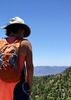
| partners | | There's like five Thumb Butte hike descriptions on Haz, most of which describe various connector trails. Despite that, there are even more trails -- numbered and otherwise -- out there than are listed here. I am not entirely sure what numbers we were on. Even after I post my route, it won't reveal numbers as MyTopo is mostly dashed line free.
Anyway, prescottstyle and I started off from somewhere west of the Prescott Shopping Center on Gurley St. We took a trail past several holes of the abadoned Troon golf course. And prescottstyle -- who knows an amazing amount of Prescott gossip -- filled me on who owned it, how they went broke, etc. He also knows plane models, minerals, trees, animals. Blows my mind! 
So, we wandered up to Thumb Butte itself, but the summit is closed until July 15 due to peregrine falcon nesting. (Which, if I was Hindu, would be what I would choose to reincarenate as.) No big deal, great views of the Prescott area were had, including several peaks I plan on hiking this summer: Tritle, Maverick, Union, Davis, etc. We may even do Little and big Granite, as the anniversary of that fire is only about three weeks away. Lots of beetle damage could be seen west of town.
Prescottsyle had some beer which he shared, and at 6.0% I could actually feel the effect for about 10 minutes. 
First four miles flew by, which is rare, and we eventually ended up finishing exactly at noon. AEG was barely noticeable.
Lots of cars heading north on 17, and *lots* of cops along 69 and 17 as well. Just on the south bound lanes, I saw five DPS between Cordes Junction and Deer Valley Rd. Guess they are getting an early start on this weekend's quota of drunks ...
-----
Video: https://www.youtube.com/embed/1OLO6DjSCy ... autoplay=1 |
|
Wildflowers Observation Light
|
|
| _____________________
| http://prestonm.com : Everyone's enjoyment of the outdoors is different and should be equally honored. |
| | |
|
|
|
 Route Editor