|
| | | |
| |
|
| Hiking | 26.77 Miles |
5,265 AEG |
| | Hiking | 26.77 Miles | 9 Hrs 55 Mns | | 2.86 mph |
| 5,265 ft AEG | 34 Mns Break | | | |
|
|
| |
| Partners |
|
none
[ show ]
| no partners | | I've been doing an annual R2R for the past dozen years or so. It's always a highlight of my hiking year, but I generally look for ways to shake up the route a bit--side hikes to ribbon falls or upper ribbon falls; taking the old devil's corkscrew and old BA alignment into Indian Garden; and one year, starting down the Old Bright Angel trail from the North Rim.
This year, I decided to try the Miner's Route on the south rim. I enjoyed it and am glad I did it, but it's probably not for everyone.
The initial ascent from where the route departs from the River Trail is particular steep and loose. And though the general direction of the route is not in question at this point (up the drainage), signs of an actual trail don't seem apparent for the first 150 feet up or so. Then some faint switchbacks appear, along with some alternate options for continuing the climb.
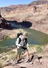
Once at the first saddle, as described in the guide, the views directly down on the Silver Bridge, up to Phantom Ranch, and over to the Black Bridge are awesome--A perspective that I don't think you can capture from any other trail location.
Just beyond the saddle is a second outcropping that provides another nice and similar view point. After taking the veiw in again, I made my most significant navigational error. I had the GPS route downloaded to RS (which was helpful), but- at this point the route took a sharp right turn and then seemed to loop up and then back to the alignment I was on already. Meanwhile, the actual landscape presented with some sheer cliff faces that could be navigated from below (walking along their base), which seemed to be the logical option on the route. Add to that a faint use trail heading towards the base of the cliff face, and I figured the sharp right on the gps track, which circled back, was probably either a gps glitch, or a false attempt that was corrected by the original hiker. Well, I figured wrong.
As you can see on my route, I ended up backtracking back and forth a bit, until I figured out that the route wasn't a glitch, but that I needed to get on top of the cliff face. As I got back to the point where I had gone off track, I saw a narrow chute that headed directly up. After climbing a bit, I rediscovered the faint signs of a trail, and once in that chute, the route was obvious again.
Other than that, I managed to stay on the route pretty well.
Once I topped out at the Miner's Cairn, I was feeling accomplished, and glad to have the scrambling mostly done. In my mind, connecting up with the Tonto from there was just a matter of a relatively flat and short 100 yard jaunt through the sagebrush. Again, wrong assumption. Getting up to the Tonto involved more elevation gain that I had figured. Nothing overly strenuous, but it was more than what I was mentally anticipating.
In any event, I finally did make the connection and was happy to be back on established trail. I passed by the Skeleton Route up to the SK trail, and flagged that for another time. It was mid-day and above 90 degrees, and I had a 4-mile shadeless walk ahead of me to connect with the Bright Angel trail, so I'll tackle that one another time.
I had not hiked this section of Tonto (except the far wester endge connecting old BA with new BA alignment). It was as enjoyable as the Tonto generally gets. I didn't realize you could seek Phantom Ranch from the Tonto. Also, the riparian areas by Burro Spring, and Pipe Spring were welcome and refreshing--(plenty of water at both, though more at Pipe Spring).
Saw only one other person from when I departed the River trail till I reached the Bright Angel trail--a single female hiking on the Tonto between Pipe and Burro Springs.
Once I hit the BA just below Indian Garden, I was back in familiar territory. I saw a helicopter fly low overhead and wondered if a rescue was underway. No. Apparently, there was some shuttle of supplies going on from or to IG.
Due to an earlier pipeline break and water conservation measures, the water was turned off at 3 mi. and 1.5 mi. resthouse, so the last water stop was IG, and I actually had to wait in line behind a dozen or so people to fill up my reserve liter bottle (which I didn't end up needing). I learned that there are quite a few people who lack any semblance of proficiency in using a water tap.
Unneeded water secured, I looked at my watch and realized I had less than two hours to get out of the Canyon, if I wanted to get a shower in a Mather Campground. [Another casualty of the water restrictions is that the showers at Mather campground close at 4pm]. Given the extra exertion on the Miner's route and 4 miles in the afternoon sun and the fact that it was 100 degrees at IG, I wasn't sure I had it in me, but resolved to give it the ol' college try.
Thankfully, the body cooperated, and I made it from IG to the top in 1 hour and 45 minutes. I zipped over to the campground and got in just under the wire. There's nothing like a hot shower after a full day in the Canyon!
After dinner at Maswick Lodge, our group headed back to Phoenix, and I arrived home a little after midnight. Tired, but fulfilled with another set of good memories from our local natural wonder of the world. |
|
Wildflowers Observation Moderate
|
|
| _____________________
| | |
|
|
|
 Route Editor


 Start getting ready 4:30 am, in car at 6 and on shuttle at 6:30.
 Switchbacks, steps and double your AEG within the last few miles.