|
| | | |
| |
|
| Hiking | 9.70 Miles |
1,741 AEG |
| | Hiking | 9.70 Miles | 4 Hrs | | 2.65 mph |
| 1,741 ft AEG | 20 Mns Break | | | |
|
|
| |
| Linked |
|
none
[ show ]
| no linked trail guides |
| Partners |
|
none
[ show ]
| no partners | | | apparently this member prefers to keep an air of mystery... | | _____________________
| | |
|
|
|
|
|
| | | |
| |
|
| Hiking | 6.00 Miles |
250 AEG |
| | Hiking | 6.00 Miles | 3 Hrs 20 Mns | | 1.95 mph |
| 250 ft AEG | 15 Mns Break | | | |
|
|
| |
| Linked |
|
none
[ show ]
| no linked trail guides |
| Partners |
|
none
[ show ]
| no partners | | | Pleasant easy hike with some early views. |
| _____________________
| | |
|
|
|
|
|
| | | |
| |
|
| Hiking | 4.70 Miles |
1,605 AEG |
| | Hiking | 4.70 Miles | 4 Hrs 15 Mns | | 1.61 mph |
| 1,605 ft AEG | 1 Hour 20 Mns Break | | | |
|
|
| |
| Linked |
|
none
[ show ]
| no linked trail guides |
| Partners |
|
none
[ show ]
| no partners | | | Was very windy and cold... |
| _____________________
| | |
|
|
|
|
|
| | | |
| |
|
| Hiking | 4.20 Miles |
450 AEG |
| | Hiking | 4.20 Miles | 3 Hrs 45 Mns | | 1.40 mph |
| 450 ft AEG | 45 Mns Break | | | |
|
|
| |
| Linked |
|
none
[ show ]
| no linked trail guides |
| Partners |
|
none
[ show ]
| no partners | | | Nice moderate hike... felt like more than 450' elevation change. |
|
Autumn Foliage Observation Isolated
|
|
|
Wildflowers Observation Isolated
|
|
| _____________________
| | |
|
|
|
|
|
| | | |
| |
|
| Hiking | 4.60 Miles |
480 AEG |
| | Hiking | 4.60 Miles | 3 Hrs 30 Mns | | 1.67 mph |
| 480 ft AEG | 45 Mns Break | | | |
|
|
| |
| Linked |
|
none
[ show ]
| no linked trail guides |
| Partners |
|
none
[ show ]
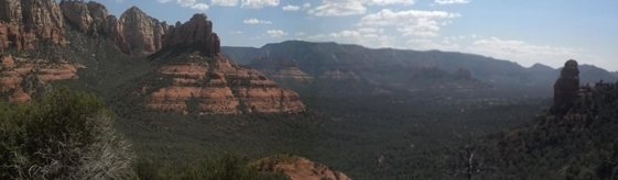
| no partners | | My most favorite hike in Sedona to date (have yet to hike Oak Creek).

Devils Kitchen, the largest sinkhole in the Sedona area, the Seven Sacred Pools (there were maybe 2.5 pools this day) and overall beauty made this a great hike.

I made it a loop with the Brins Mesa Trail... added less than a mile to the hike and was worth it:
 |
| _____________________
| | |
|
|
|
|
|
| | | |
| |
|
| Hiking | 3.50 Miles |
870 AEG |
| | Hiking | 3.50 Miles | 2 Hrs 30 Mns | | 1.56 mph |
| 870 ft AEG | 15 Mns Break | | | |
|
|
| |
| Linked |
|
none
[ show ]
| no linked trail guides |
| Partners |
|
none
[ show ]
| no partners | | Finding the Grape Vine Road turn off is 'easy' (heading west from I-17) if you follow mile markers....if you pass mile marker 274 you missed the turn by 200 feet... south side of 69. Look for the 'Do Not Enter' sign on the south side of the road. Grape Vine Road is 100 feet east from this sign (see photo):
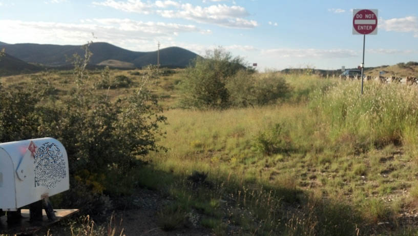
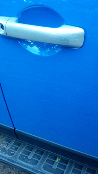
Only high clearance 4x4 vehicles can get to the trailhead....also, expect "Arizona Pinstripes" (scratched paint)... It's a rough road.... Kinda fun if you have a jeep or something similar.
Again: The last 1.5 mile drive to the "trail head" is only possible if you have both a high-clearance and 4X4 vehicle. No exceptions. Your paint job won't quite be the same afterwards either:
The trail itself is pleasant and not well-traveled . Hikers will need bug spray.
See photos:http://hikearizona.com/photo.php?ZIP=283996 |
|
Autumn Foliage Observation Isolated
|
|
|
Wildflowers Observation Isolated
|
|
| _____________________
| | |
|
|
|
|
|
| | | |
| |
|
| Hiking | 4.60 Miles |
810 AEG |
| | Hiking | 4.60 Miles | 3 Hrs 30 Mns | | 1.67 mph |
| 810 ft AEG | 45 Mns Break | | | |
|
|
| |
| Linked |
|
none
[ show ]
| no linked trail guides |
| Partners |
|
none
[ show ]
| no partners | | Beautiful hike.

 |
| _____________________
| | |
|
|
|
|
|
| | | |
| |
|
| Hiking | 6.00 Miles |
400 AEG |
| | Hiking | 6.00 Miles | 3 Hrs 30 Mns | | 2.18 mph |
| 400 ft AEG | 45 Mns Break | | | |
|
|
| |
| Linked |
|
none
[ show ]
| no linked trail guides |
| Partners |
|
none
[ show ]
| no partners | | | Awesome hike... Fisher Point was very unique and a pleasant surprise. |
|
Wildflowers Observation Substantial
|
|
| _____________________
| | |
|
|
|
|
|
| | | |
| |
|
| Hiking | 10.00 Miles |
1,950 AEG |
| | Hiking | 10.00 Miles | 7 Hrs | | 1.60 mph |
| 1,950 ft AEG | 45 Mns Break | | | |
|
|
| |
| Linked |
|
none
[ show ]
| no linked trail guides |
| Partners |
|
none
[ show ]
| no partners | | | I think I did this hike out of season.... pretty warm in August. |
| _____________________
| | |
|
|
|
|
|
| | | |
| |
|
| Hiking | 5.80 Miles |
500 AEG |
| | Hiking | 5.80 Miles | 6 Hrs 30 Mns | | 1.93 mph |
| 500 ft AEG | 3 Hrs 30 Mns Break | 20 LBS Pack | | |
|
|
| |
| Linked |
|
none
[ show ]
| no linked trail guides |
| Partners |
|
none
[ show ]
| no partners | | | apparently this member prefers to keep an air of mystery... |
|
Wildflowers Observation Isolated
|
|
| _____________________
| | |
|
|
|
|
|
| | | |
| |
|
| Hike & Climb | 2.00 Miles |
600 AEG |
| | Hike & Climb | 2.00 Miles | 1 Hour 20 Mns | | 1.50 mph |
| 600 ft AEG | | | | |
|
|
| | |
| Linked |
|
none
[ show ]
| no linked trail guides |
| Partners |
|
none
[ show ]
| no partners | | | presumably took memories and left without a trace... | | _____________________
| | |
|
|
|
|
|
| | | |
| |
|
| Hiking | 8.20 Miles |
1,700 AEG |
| | Hiking | 8.20 Miles | 4 Hrs 45 Mns | | 2.05 mph |
| 1,700 ft AEG | 45 Mns Break | | | |
|
|
| |
| Linked |
|
none
[ show ]
| no linked trail guides |
| Partners |
|
none
[ show ]
| no partners | | First time doing this hike... this trail doesn't appear to end with the typical 'hike to the top and you're done'...
The 'Little Granite Mountain Loop' was much more scenic. |
| _____________________
| | |
|
|
|
|
|
| | | |
| |
|
| Hiking | 5.00 Miles |
685 AEG |
| | Hiking | 5.00 Miles | 3 Hrs 45 Mns | | 1.54 mph |
| 685 ft AEG | 30 Mns Break | | | |
|
|
| |
| Partners |
|
none
[ show ]
| no partners | |  Boynton Canyon - Sedona - Memorial Day 2012 Boynton Canyon - Sedona - Memorial Day 2012
Did the Vista Trail Vortex-thing... ] ](https://hikearizona.com/dex2/images/smilies/eusa_wall.gif "Brick wall")
...then to the end of Boynton Box Canyon...
..and back.
|
| _____________________
| | |
|
|
|
|
|
| | | |
| |
|
| Hiking | 6.40 Miles |
900 AEG |
| | Hiking | 6.40 Miles | 4 Hrs 20 Mns | | 1.79 mph |
| 900 ft AEG | 45 Mns Break | 25 LBS Pack | | |
|
|
| |
| Linked |
|
none
[ show ]
| no linked trail guides |
| Partners |
|
none
[ show ]
| no partners | | This Mother's Day hike was a bit more challenging than I anticipated... could see smoke from the forest fires just to the south. Was going to try to loop it back but I was done going up.  |
|
Wildflowers Observation Isolated
|
|
| _____________________
| | |
|
|
|
|
|
| | | |
| |
|
| Hiking | 9.00 Miles |
1,700 AEG |
| | Hiking | 9.00 Miles | 5 Hrs 30 Mns | | 1.80 mph |
| 1,700 ft AEG | 30 Mns Break | 20 LBS Pack | | |
|
|
| |
| Linked |
|
none
[ show ]
| no linked trail guides |
| Partners |
|
none
[ show ]
| no partners | | | presumably took memories and left without a trace... | | _____________________
| | |
|
|
|
|
|
| | | |
| |
|
| Hiking | 6.70 Miles |
1,370 AEG |
| | Hiking | 6.70 Miles | 5 Hrs 30 Mns | | 1.49 mph |
| 1,370 ft AEG | 1 Hour Break | 20 LBS Pack | | |
|
|
| |
| Linked |
|
none
[ show ]
| no linked trail guides |
| Partners |
|
none
[ show ]
| no partners | | Started this loop at the Iron Springs Road trailhead and took the loop counter-clockwise. This was my first significant Prescott hike since moving here.
Very impressive hike. Very beautiful granite rock gardens. Vistas were outstanding. |
|
Wildflowers Observation Light
|
|
| _____________________
| | |
|
|
|
|
|
| | | |
| |
|
| Hiking | 10.10 Miles |
1,967 AEG |
| | Hiking | 10.10 Miles | 6 Hrs | | 2.24 mph |
| 1,967 ft AEG | 1 Hour 30 Mns Break | | | |
|
|
| |
| Linked |
|
none
[ show ]
| no linked trail guides |
| Partners |
|
none
[ show ]
| no partners | | Did this loop counter clockwise with overcast and mild weather.
I never seen so many mountain bikers on a trail before. |
| _____________________
| | |
|
|
|
|
average hiking speed 1.8 mph
WARNING! Hiking and outdoor related sports can be dangerous. Be responsible and prepare for the trip. Study the area you are entering and plan accordingly. Dress for the current and unexpected weather changes. Take plenty of water. Never go alone. Make an itinerary with your plan(s), route(s), destination(s) and expected return time. Give your itinerary to trusted family and/or friends.
 Route Editor