| |
| Peak 3595 - Mineral Mountain Quad, AZ | | -
-
-
| 1 label | 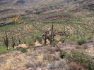 |
|
|
-
| 1 label | 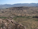 |
|
|
-
| 1 label | 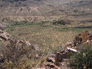 |
|
1 |
-
-
| |  |
|
4 |
-
-
-
-
-
| 1 label | 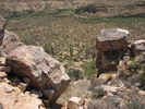 |
|
|
-
| 1 label |  |
|
|
-
| |  |
|
2 |
-
|
| | Peak 3595 - Mineral Mountain Quad, AZ | | | |
|
|
Peak 3595 - Mineral Mountain Quad, AZ
| | |
|
| Hiking | 0.91 Miles |
585 AEG |
| | Hiking | 0.91 Miles | 1 Hour 2 Mns | | 1.11 mph |
| 585 ft AEG | 13 Mns Break | 22 LBS Pack | | |
|
|
| |
| Linked |
|
none
[ show ]
| no linked trail guides |
| Partners |
|
none
[ show ]
| no partners | | Next climb for the day... After noting the burned area on this peak while on my first climb of the day, I spent some extra time driving back and forth on Telegraph Canyon Road scanning for the best approach from the road. Initially I had planned on ascending the spine of the ridge from the north (the Picketpost end) but I was leary of the terrain in the aftermath of the fire. Although I decided on an approach from the SE, I parked a bit farther north with the idea of climbing up to the rocky part, then traversing southward across the slope with an eye out for an easier shot at the summit.
I wasn't very far from the rocky part when I could see an opening that may or may not provide an alternate route. When I reached the area I found a nice chute through the steep lower section of the rocks. Once through the chute there was another 250-300 feet to go and although there was brush to grab onto, it was very steep. The type of area I don't mind climbing but I absolutely hate them on descents.
I was so focused on my footing that I was almost caught by surprise when I reached the summit. I had expected it to be farther north into the burned area along the ridge. I took a 360 pan video then some photos while checking out the extent of the fire. Although supposedly only 208 acres went up in smoke, it appears the fire burned all the way down the western slope of 3595 and across right up to the Arizona Trail, where it stopped. Thankfully that's as far as it got.
While at the summit I scanned over at Peak 3540, the next 'possible' peak on my list less than a mile to the south. Whether I dropped down the 'back' of the peak I was on to head over that way or back down to the road to drive closer, I did not care at all for the terrain. While I could not see the western slope of 3540, I had a feeling it may be the best option. But it would entail driving well past it and hiking a few miles back on the AZT before I began the climb. So I put it off for now. As it turned out, when I got to the last summit of the day on Peak 3950 I had a clear view of the western slope and it is, in fact the best option. I'll be back soon.
Now I've got the fun descent through the loose terrain... oh yeah, and the knees and ankles are both complaining already today. But with extra care it wasn't long and I was heading down through the chute followed by a bee-line across the lower slope to the car. Although I had expected this climb to take more time than the first during my planning stages, it turned to take half the time... a pleasant surprise.
Photos are posted on HAZ as well as my web site:
Peak 3595 photos
My 90-second 360-degree pan video from the summit is here:
Peak 3595 summit panorama |
| _____________________
| | |
|
|
|
|
|
| |
 Route Editor


