| | -
-
-
-
-
-
-
-
-
-
-
-
| |  |
|
4 |
-
-
-
|
| | |
|
| Hiking | 8.80 Miles |
2,130 AEG |
| | Hiking | 8.80 Miles | | | |
| 2,130 ft AEG | | 22 LBS Pack | | |
|
|
| |
| Linked |
|
none
[ show ]
| no linked trail guides |
| Partners |
|
none
[ show ]
| no partners | | Note: I still have a smudge on the right side of my camera lens, so some images are blurry (thought I got it cleaned!)
This past weekend (12/19 - 12/21), I made my final backpacking trip for 2014. My basic route was:
Day 1: hike the Derrick Trail to the Highline Trail, head East on the Highline trail and camp near Chistopher Creek
Day 2: hike the See Canyon Trail up to FR300, hike West along FR300 for a few miles, then take the Horton Creek trail down the rim and make camp near Horton Creek
Day 3: hike back to car
This loop has been on my “to-hike” list for a couple years now, and I'm glad I finally hiked it. It is a great connection of trails less than 2 hours from Phoenix.
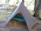
Day 1: given last week's weather, I had no idea how much snow to expect on the trail, so I came prepared to hike and camp in several inches of the stuff. Starting off on the Derrick Trail, I saw almost no snow and felt over-prepared. However, as I got closer to the rim and met up with the Highline Trail, the snow increased and so did the mud. Both of these made this section of the Highline Trail much more interesting than I remember it. Hiking was smooth and generally easy, but with about half a mile to reach Christopher Creek, my shoes reached terminal mud. I am certain my shoe weight quadrupled. Thankfully the trail dried out a little more as I descended to Christopher Creek. I found a nice spot on the East side of the creek, setup camp, and managed to get a fire going (which was difficult given that all the wood was soaked). I went to bed shortly after dark (thermometer already read 35F) having seen no one the entire day except at the trailhead. Around 8 pm, I woke up to someone walking around my tent and shining a flashlight on it. I said “hello” and received no response. Strange...And then around 11 pm, I was again woken up to flashlights on my tent by people on the other side of the creek, I presume looking for a camp site. They gave up and left after a few minutes.
Day 2: in order to make the long 13+ hour winter nights bearable, I get up early, eat breakfast, and pack up in the dark so that I am ready to go near first light. This morning was a cozy 28F, made apparent by the sparkly interior of my frosty tent. To warm up, my dog and I set off on the beautiful See Canyon Trail. If I were to repeat this loop, I would not camp near the Highline Trail and Christopher Creek; instead, there is a nice spot to camp just a 1-2 minute walk North of the See Canyon trailhead which should be much more private. An even better option for backpackers may be the small camp site just past the intersection with the trail that goes off to See Spring. As I hike along the See Canyon trail, gradually climbing, I think I am making good time and will be at the top of the rim soon. After all, the sign only said “2 miles”. Pretty soon though, I am walking through more and more snow and the trail gets significantly steeper. The path is fairly well-marked and I only lost the trail a half dozen times or so. Whenever I lost the trail, I just looked for sawn logs, which are the most obvious man-made feature when everything is covered in snow. My dog is also pretty good at sniffing out where to go.
Eventually, I reach FR300! Upon stepping foot on the road, I immediately see a car and think that it will be a long few miles avoiding vehicle traffic. But that would be the only car I'd see the entire time. My dog and I walk along the snow-covered road at a brisk pace, making good time thanks to the compacted snow in the tire tracks. After the climb up to the rim, I am glad for some easy miles. FR300 actually makes for quite the pleasant hike in the winter time. Pretty soon, we reach the Horton Creek Trail sign and begin our descent. I had no idea if this trail even really existed and I was happy to find it pretty well maintained. It was easier to follow than the See Canyon Trail and there was less snow. I think this trail is more frequently traveled by Elk than by people – there was tons of Elk poop along almost the entire length. The descent is steep, but we reach Horton Creek, check out the spring, have some food, and then hike on another mile or so. I manage to find a nice spot on the East side of Horton Creek and set up camp. As I am eating dinner, a group of around 12 Elk walk within 50 feet of me. They seem not to care about me or my dog. As soon as I greet them with a “Hello Elk!”, they all trot away up the hill.
Throughout the night, I would occasionally hear the sound of wood snapping and rocks tumbling as elk made their way along the nearby game trail. It was a cold day and I went to bed early (my thermometer read 34F at 3pm!). The only person I saw the entire day was the lone car on FR300.
Day 3: not much here. The temperature only dipped to 30F over night. I eat breakfast and pack up in the dark again, then quickly hike out the remaining few miles to the car, again seeing no one. |
| _____________________
| | |
|
|
|
|
|
| |
 Route Editor


