| | -
| 2 labels |  |
|
|
-
-
-
-
-
| 1 label | 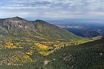 |
|
|
-
| 2 labels | 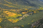 |
|
|
-
-
| 2 labels | 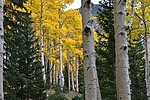 |
|
|
-
-
|
| | |
|
| Hiking | 14.04 Miles |
4,051 AEG |
| | Hiking | 14.04 Miles | 12 Hrs | | 2.16 mph |
| 4,051 ft AEG | 5 Hrs 30 Mns Break | | | |
|
|
| |
| Partners |
|
none
[ show ]
| no partners | | A friend and I went out and back, sort of, up Fremont to get a look over the fall color. South side of the mountain is dragging this year, so we started from Lockett and hoped the recent storm sped things up at least in the Inner Basin. Got going around 6am.
Passed a couple people straight away and then saw no one until coming back down the steeper parts of Inner Basin Trail. Never seen the IB switchbacks in full glow, wasn't the day for it. Upper IB is at peak. Not too much green left and not too many leaves on the ground.
Weatherford to Fremont (the upper) Saddle for the split ascent up the ridge. Made the summit below cloudy skies. Eventually they cleared and Inner Basin started to glow. The turn in IB is mostly just higher up, so all the nearest stands were shining. Three and a half hours on the summit soaking it in, tossed out any plans at adding anything else to the day.
Down toward Doyle Saddle and cut down a rock/ash slide to save a mile. Awesome views as the sun got low. Digging heels in could practically ski down the mountain.
Went a different way through IB. Took a use trail to the sort-of-secret meadow south of the trail. Better colors there than on the trail proper. Got down to the waterline jct and took it south through the yellow toward Sugarloaf. Got down too late and decided to skip the trip up.
40-60s, not too many people there even for a weekday. Lots of campers. |
|
Autumn Foliage Observation Moderate
Inner Basin peaking up top, starting down low, waterline green where it meets IB, peak south of IB |
|
| | |
|
|
|
|
|
| |
 Route Editor


