| | -
-
| 1 label | 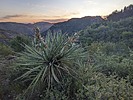 |
|
|
-
-
-
-
-
| 1 label | 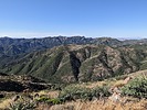 |
|
|
-
| 4 labels | 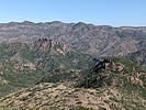 |
|
|
-
| 1 label |  |
|
|
-
| 1 label | 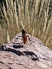 |
|
|
-
| 1 label |  |
|
|
-
|
| | |
|
| Hiking | 11.80 Miles |
3,196 AEG |
| | Hiking | 11.80 Miles | 5 Hrs 3 Mns | | 2.59 mph |
| 3,196 ft AEG | 30 Mns Break | | | |
|
|
| |
| Partners |
|
none
[ show ]
| no partners | | In regard to the Bull Basin Trail, the same as what Ms. Stardust said previously. Essentially a one-off in its current lousy condition. I regularly thought I was going to step on a viper or come face-to-face with a bear tunneling through the vegetation from about miles three through six (CW loop ascending). Gritty and painful chaparral slogging with not many views. Don't plan on making good time through this section. I had researched FOTG's and some others routes for Government Hill and was strongly drawn to bailing from the Bull Basin Trail on GH's western side and traversing over the top, but stuck it out like a bull because I wanted to complete the whole trail and not have to go back and repeat the torture again. Once reaching the Haunted Canyon Trail, the hiking was more enjoyable and quicker. I ascended/descended the standard Government Hill route, which was surprising good (practically zero bushwhacking). The views were better than expected also. The descent of Paradise was unique and quite pretty with plentiful water sources still. Someone has pruned recently, but there is one massive deadfall that blocks the whole trail on the lower section. One of the best highlights was two small yellow/black birds (orioles?) that were battling a Hau'Pal on the trail in front of me. Another significant observation was all the bear scat and tracks throughout the loop. The cypress groves are also neat and remind me of Stewart Pocket. Yup, Supes hiking in mid June!  |
| |
|
|
|
|
|
| |
 Route Editor


