| | -
-
| 1 label | 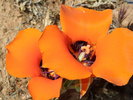 |
|
|
-
| 1 label | 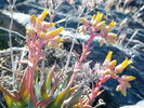 |
|
|
-
| 1 label | 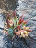 |
|
|
-
| 1 label |  |
|
|
-
-
-
-
-
|
| | |
|
| Hiking | 13.00 Miles |
3,223 AEG |
| | Hiking | 13.00 Miles | 5 Hrs 30 Mns | | 2.36 mph |
| 3,223 ft AEG | | | | |
|
|
| |
| Partners |
|
none
[ show ]
| no partners | | With tax season over, I headed out to hike the new trail to Tom's Thumb that the McDowell Sonoran Preserve had been building.
I started from the parking lot for the Horseshoe Trail to the Windgate Pass Trail. When the Gateway Visitor Center opens on May 2, you should start from there. The new trail up the west slope to Tom's Thumb leaves the Windgate Pass Trail at approximately 3 miles and is well marked. It is past the Desert Park trail junction and before Inspiration Point. These new trails look like they were engineered to accomodate mountain bikers. At 4.5 miles I was amazed by the water flowing from a spring. I met a steward who told me this was Frasier's Spring. MapSource Topo shows this as Mountain Spring. The steward showed me where the petroglyphs are but I'm not revealing that here - only to reputable 'glyphers who email me. The steward also told me she was hiking a loop today with the East End Trail. Shortly after the Spring, the trail begins the real climbing and switchbacking up to Tom's Thumb. Just before Tom's Thumb, there is a junction with the Lookout Trail. I had my new Binos so I took this 1/2 mile trail to the Lookout, ate lunch and glassed Scottsdale and Fountain Hills. Back to the trail, I decided to make a loop by continuing east on the trail to the East End Trail. There is quite an intersection where the old Tom's Thumb Trail comes in. I expect Scottsdale will put in a stop light and photo radar here someday. I proceeded south on the East End Trail. Very expansive views. This trail intersects the Windmill Trail so I turned west and hike about 1/10th mile to the Windgate Pass - Bell Pass Junction. You could combine this with the Bell Pass Trail and make a real big loop. Today I hiked in on the Windgate Pass Trail. 13 miles 3,223 AEG 5.5 hours. |
|
Wildflowers Observation Light
|
|
| _____________________
Anybody can make a hike harder. The real skill comes in making the hike easier.
life is like a roll of toilet paper. The closer it gets to the end, the faster it goes. Andy Rooney |
| | |
|
|
|
|
|
| |
 Route Editor


