username
X
password
register
for free!
help
ArticlesGuidesRoutes
 
Photosets
 
 Comments
triplogs   photosets   labels comments more
Bulldog Cyn to Salt River - 8 members in 29 triplogs have rated this an average 3.3 ( 1 to 5 best )
1, 2  Next
29 triplogs
login for filter options
Jan 04 2025
avatar

 Guides 2
 Routes 31
 Photos 902
 Triplogs 50

male
 Joined Sep 19 2020
 Phoenix
Top Hat LoopPhoenix, AZ
Phoenix, AZ
Hiking avatar Jan 04 2025
ScottHikaTriplogs 50
Hiking10.00 Miles 1,500 AEG
Hiking10.00 Miles
1,500 ft AEG
 
1st trip
Partners none no partners
I was privileged to be invited on a Goldfields summit trip by a tough group of fast hikers. We arrived just before dawn to witness an amazing sunrise over Bulldog Canyon at Wolverine Gate. The usual ATV off-road gang had not arrived yet, so we began a dust-free morning with temperatures around 50 degrees. Our first target was the summit of Weeks Benchmark, locally known as Top Hat Hill. The nickname is fitting as it indeed resembles a top hat when approached. We expected some sort of lollipop or barbell loop back.

I had not been to either summit before. We took more-or-less the official Top Hat route, a clockwise loop from the west. There is a 1958 USCGS summit benchmark there, without an elevation mark, but it seems to be around 2520 feet. Some of us signed the summit register, grabbed some photos, and then quickly headed off in a northerly direction. Afterward, we took a short trip to “Palo Verde Arch,” which is also known as “Pedestal Arch” or “Picture Arch”—we weren't sure of the exact name. It's a beautiful arch with a small window at the bottom. Looks great from both sides. We made our way down the northern slope towards our next target, an obscure peak at 2531 feet.

The Goldfields have many similar peaks, making it a challenge to log them all, but it would be a big accomplishment to bag them all. Most of the terrain was grassy, not too overgrown, mostly stable, moderately sloped, and composed of volcanic tuff. No injuries or falls for the day, which was awesome. I did get a little turned around, so I need to spend more time there. Summit 2531 is less prominent than Top Hat but has a similar elevation. We had a snack, took more photos, and enjoyed some social time before the road walk back.

We crossed paths with one hiker and a slew of OHV enthusiasts. We made quick time over the well-maintained roads. It was somewhat dusty on the way back due to the vehicles, as expected. We went over the mountain on the way up and around it on the return. We walked up to the lot around noon, 10 miles later and slight 1500 ft. gains. The lot was packed, and trucks lined the road out. There was even a FS truck monitoring the entrance. It was another good day with a tight group and cool people.
 Geology
 Geology [ checklist ]
[ checklist ]  Natural Arch
  6 archives
Apr 14 2024
avatar

 Guides 1
 Routes 14
 Photos 7,202
 Triplogs 5,208

68 male
 Joined Mar 16 2008
 chandler,az
Dome Mountain 3381 - Goldfield MtnsPhoenix, AZ
Phoenix, AZ
Hiking avatar Apr 14 2024
johnlpTriplogs 5,208
Hiking8.30 Miles 2,280 AEG
Hiking8.30 Miles
2,280 ft AEG
 no routes
Linked   linked  
Partners partners
trekkin_gecko
We set out to hike Dome Mountain, then add on something. We chose Peak 3269. We overshot 3269 and ended up on 3238 first which was fortunate because we spooked a herd of bighorn sheep. Counted nine. There may have been a few more.
We headed back to Peak 3269 before returning to Dome and descending the steep trail.
Kelly loved the sidehill off trail and the steep loose trail to Dome Mountain as well.
Good wildflower display. Foxtail are drying out and will become intolerable soon.
Fun day. Thanks Kelly. :)
 Flora
 Flora [ checklist ]
[ checklist ]  Dudleya
wildflower observationwildflower observationwildflower observationwildflower observationwildflower observation
Wildflowers Observation Moderate
_____________________
“Good people drink good beer.” Hunter S Thompson
 
Jan 08 2023
avatar

 Guides 21
 Routes 1,182
 Photos 36,858
 Triplogs 1,570

69 female
 Joined Feb 26 2004
 Phoenix, AZ
Bulldog Canyon - Blue Ridge Loop, AZ 
Bulldog Canyon - Blue Ridge Loop, AZ
 
Hiking avatar Jan 08 2023
tibberTriplogs 1,570
Hiking6.77 Miles 928 AEG
Hiking6.77 Miles   3 Hrs   33 Mns   2.04 mph
928 ft AEG      14 Mns Break
 
Route Scout Route Recorded  on Route Scout | Pop | Map | Popup | MapDEX
Cousin Jaelyn cut her South America trip short and ended up at her mom's house in San Tan Valley and texted me for a hike. I called Deborah who was also in town and I picked this hike that I took Jaelyn's sister on Dec 2021 [ photoset ] . Weather was perfect. The road walk was VERY noisy until making the turn on FR 10 to the north. From then on we only saw horseback riders.

As we came down the hill, to the NW I could see what looked like a stone wall. I had never noticed it before. It looks natural and there is a pullout below it. Even though I hiked us past the wash turn, misreading RS, we didn't get close enough to investigate. We headed back to the wash, took the obligatory picture by the tall chollas and continued to our first destination: Cyclops. Jaelyn took the lead and nailed the cairned route on the way up. We took our pictures and enjoyed the always beautiful view :) . We got to see a red-tailed hawk in flight as well. Jaelyn removed her first cholla from her shoe.

We headed back down and Jaelyn kept heading east while we went down the way we came up. We headed toward the bedrock area of the wash looking for reflections in the water but the horses had been through so the water was a little mucky in most of the little pools. It's still a little hard to follow the trail from time to time so sometimes, we probably hiked more through the wash. However, the sand was somewhat hardened in many areas so it wasn't bad. I do like staying above the wash for the views. And since this was Jaelyn's first time in this area (she's only done Picacho with me on this very same day 12 years ago [ photoset ] ), I wanted her to have a good visual.

I tried to point out the various peaks and we reviewed some of the flora. She's a bit of a gardener so likes to know about the desert; doesn't quite compare to Kona, but our desert was showing off with all its puffy chollas and various other plants including Jojobas and Foothill Palo Verdes not to mention the Saguaros that she couldn't get enough of; especially their interior when it was exposed. Deborah also likes the desert flora.

Keeping an eye out for the cairns is still a bit tricky. As we meandered along I noticed the horses went off to the south from the wash. After checking HAZel, I knew this wasn't the right way but we decided to be adventurous and follow where it would lead us as long as it kept going the way I needed it to. The horse people have been out trimming so we tossed the clippings off the trail which was quite narrow in this particular section. Well this is definitely NOT a main trail so eventually I needed to veer east, but first we had to get up on a hill so I could get a good visual.

We walked on the top and enjoyed our views. I found a good route down and we took that and with a little jig and jag via FR 1356 I got us on a rough road that would take us up another tall and long hill. Now I just had to hope we could hook up with Blue Ridge ridge area. Believe it or not, the road turned into a single track and was even heading in the right direction. So the only question remaining was whether or not we would have to go down to go up. I pointed out the views to Top Hat, the Four Peaks, Weavers and the Flatiron as we continued on our way. And wha la, we were able to merge to the next ridgeline that would take us on the Blue Ridge.

We got over to the main area where you can look toward the alcove below. The lichen was glowing per normal and is a sight to see if you're not used to seeing such masses of it. Walking around this volcanic tuff is pretty at every turn. It's a little different than volcanic tuff that Jaelyn has in Kona but at least she could somewhat feel at home :lol: ; especially since Kihlauea is at it again. Now it was time to negotiate that slippery section coming down from the Blue Ridge. It's still slick but fortunately, short. I am still amazed that horses traverse that.

We finished off the hike by getting to see some deer grazing on the side of the hill so that was nice. It's a little tricky getting back to the TH once you're near the wash and though I apparently missed the trail, we made it to the road with no problem. I think some of these trails in here are hard to see because of the rain we've had.

We finished our day at Los Gringos where Jaelyn and I enjoyed a Grande Waborita with our food. (FYI, the poblano chicken enchiladas and poblano rice are so good).

WATCH: 1:24-4:57PM, 6.46 miles, 2102-2513 feet. 134 avg bpm, 166 max. 31% Zone 5 max, 54% Zone 4 anaerobic, 15% Zone 3 aerobic burning 1450 calories. Temp 63.8 sunny and 36% humidity.
_____________________
For me, sometimes it's just as much about the journey as the destination.
Oh, and once in awhile, don't forget to look back at the trail you've traveled.
 
Sep 25 2022
avatar

 Guides 27
 Routes 669
 Photos 12,096
 Triplogs 856

56 male
 Joined Jul 05 2006
 Mesa, AZ
Bulldog Canyon / Lower Bulldog CanyonPhoenix, AZ
Phoenix, AZ
Hiking avatar Sep 25 2022
DarthStillerTriplogs 856
Hiking10.68 Miles 996 AEG
Hiking10.68 Miles   4 Hrs   32 Mns   2.36 mph
996 ft AEG
 
1st trip
Linked   linked  
Partners none no partners
Started from the north end by Blue Point along the Bush Highway. Hiked in about 5.3 miles and turned around. I had shade for most of the first 3 miles then had to put my hood up. It seemed kind of hot at first once the sun hit, but then it seemed not so bad once the sun drenched everything.

I was the only hiker for this one, just saw people in side by sides, 4WDs, and one mountain biker. Once you get into the heart of the canyon the scenery really becomes nice. the power lines detract from it a little, but not too much.

Once I was done there was a group of Forest Service Law Enforcement cars at the trailhead that were starting to escort 3 Mercedes bus limos up FR10. The one officer asked me if I saw any snakes.

Nothing big or notable happened, other than cooler than expected temps, which was very welcome.
_____________________
  1 archive
Jan 29 2022
avatar

 Routes 93
 Photos 7,758
 Triplogs 1,691

64 male
 Joined Mar 11 2003
 AZ
Windy Dome Bushwhack Loop, AZ 
Windy Dome Bushwhack Loop, AZ
 
Hiking avatar Jan 29 2022
wallyfrackTriplogs 1,691
Hiking12.29 Miles 3,110 AEG
Hiking12.29 Miles   8 Hrs   4 Mns   1.75 mph
3,110 ft AEG   1 Hour   2 Mns Break
 no routes
1st trip
Partners partners
joebartels
The_Eagle
I was loving the Goldfields until I wasn't. :o The start was a cool 51 degrees with the wind blowing away. The road hiking was easy and the first wash was choked but relatively easy to navigate. The wash up to the saddle was ugly and the traverse up to on ball bearing gravel into the wind tunnel was down right annoying. The cairned route up to Dome Mountain with the wind at our backs was a welcome relief. The guzzler was an interesting distraction and the lunch spot top notch. The ridgeline over to the high point of the hike was well the high point and it went down hill from there. Even the wildlife wasn't anywhere to be found in the thicket. For a while I was thinking this should have been called the Dumb Dumb route but I fell for it. :doh: We were glad to finally find the trail and it was easy going back. There was good and bad. It was nice to get out with Joe & Bruce and I got to see more of The Goldfields. In the end I'm glad I hiked this route and I'm equally glad it's over.
_____________________
  1 archive
Jan 29 2022
avatar

 Guides 41
 Routes 1,626
 Photos 14,983
 Triplogs 2,760

69 male
 Joined Jan 20 2009
 Far NE Phoenix,
Windy Dome Bushwhack Loop, AZ 
Windy Dome Bushwhack Loop, AZ
 
Hiking avatar Jan 29 2022
The_EagleTriplogs 2,760
Hiking12.69 Miles 3,005 AEG
Hiking12.69 Miles   8 Hrs   4 Mns   1.82 mph
3,005 ft AEG   1 Hour   6 Mns Break14 LBS Pack
 
1st trip
Route Scout Route Recorded  on Route Scout | Pop | Map | Popup | MapDEX
I like to try new things, and I have not spent much time in the Goldfields. I know that Joe prefers traveling across the valley to do the Goldfields over he Supes, loves bushwhacking and give him a high wind condition, and he is as happy as a clam. Who am I to deny him all this. Wally joined us and Denny was a now show because he was hitting up the Night Club and beach scene in Miami for the weekend.

I cobbled together a bunch of tracks to take us on a tour of the Goldfields including both Dome Mountains.

We walked through the unlocked and open gate around 7:30 and immediately talked to a hiker who said he was just returning from hiking to Dome Mountain. Joe got all excited when he commented at how windy it was.

FR10 was a nice way to warm up the joints for the climb later. We passed a few people camping but only one Jeep on the move. We hit up a minor cave and a couple of small arches before making our climb up the drainage up the west side to the saddle of the Domes. It's a steady climb, lots-o-bolder hopping and prickly stuff to avoid. It's very slow going. Joe was happy as a clam all the way up. I think he sang every Disney song in the catalog.

Up at the saddle, we took a break out of the wind and contemplated our next move. We ditched the idea of climbing to the lower Dome Mountain. It was into the strong wind. We were afraid that Joe would go all Sally Fields on us, turning into the Flying Nun and whisk his way off the mountain.

We hit up Dome 3381 to the north before retreating down to the Tiki Bar guzzler called Goldfield Two.

After lunch and Joe's conversation with a crow, we started the ridgeline portion of this hike. This was much better (and easier) than expected.

Now we got to the part that got Joe most excited. We got to a point where we decided to take a shortcut. Joe needed to get home for his Saturday afternoon waxing. (I did not ask) We cut down a canyon that was easy peazy to begin with. It got thicker, steeper, pokier and rockier. I've never seen Joe happier.

At the bottom of the canyon he wanted to stretch the hike info some thing longer, but Wally and I talked him out of it.

We finally hit some nice trails the roads for the return to the TH. The Goldfields really have some excellent views and options. I would not be surprised if this was the new daily Piestewa hike for him.
 Fauna
 Fauna [ checklist ]
[ checklist ]  Millipede
_____________________
There is a very fine line between "hobby" and "mental illness."
Dave Barry 🦅
  2 archives
Jan 29 2022
avatar

 Guides 264
 Routes 2,797
 Photos 14,494
 Triplogs 5,894

55 male
 Joined Nov 20 1996
 
Windy Dome Bushwhack Loop, AZ 
Windy Dome Bushwhack Loop, AZ
 
Hiking avatar Jan 29 2022
joebartelsTriplogs 5,894
Hiking12.29 Miles 3,110 AEG
Hiking12.29 Miles   8 Hrs   4 Mns   1.75 mph
3,110 ft AEG   1 Hour   2 Mns Break
 
1st trip
Partners partners
The_Eagle
wallyfrack
Route Scout Route Recorded  on Route Scout | Pop | Map | Popup | MapDEX
My heart wasn't in this from the get-go. Traveling across the entire valley to Usery or the Goldfields is stopping short of hikes I prefer. Nobody likes bushwhacking and the wind is my nemesis. On the bright side, a different pair of wind goggles worked much better than what I'd been using.

This was my first visit to the Bulldog vicinity so it was good to finally see where throngs of valley hikers explore. It was my assumption the area was a trashed wasteland. Everything I saw was leaps and bounds better than anticipated.

We hiked FR10 to the westside of the Dome peaks with a mini foray into Bulldog Canyon along the way to cutout road walk. The twin Dome mountains never caught my attention being just a half-mile apart. It makes sense though, the north is in Stewart Mtn topo and the south is in Apache Junction topo.

We hiked Satan's Windtunnel Backyard to the saddle between the peaks. Skipped the south/3269/3239 and headed for the north/3381. The route is well cairned and we were on top much quicker than anticipated (from the saddle). I'm sure it's great and all but I just wanted to leave.

When all seemed hopeless, we dropped down to the guzzler. Out of the wind, it seemed odd this might be the highlight of the day but boy was I happy to travel with full vision. Then up to a saddle for lunch with a crow serenading. After lunch, the pace finally picked up roller coastering mini high points of a ridge. Kinna like highjacking a preschool edition to the motherlode (at warp speed, the peaks are maybe 50 ft tall... lol).

Somebody suggested cutting down and over. Like any ignorant wide-eyed group of fools, we agreed in unison to give it a go. Now into the flipside of Satan's Backyard and sick on the poisoned lure with the stupidity of real men don't backtrack, Bruce sold it as a tibber track so we forged onward.

With another option to change the course we wearily voted on another shortcut. After a short break to pray for forgiving terrain, we gave it a go. Luck finally kicked in and it was a freeway route to the Official Route.
_____________________
- joe
 
Jan 27 2022
avatar

 Guides 116
 Routes 337
 Photos 11,399
 Triplogs 894

63 male
 Joined Dec 20 2010
 Sunnyslope, PHX
Bulldog Cyn to Salt RiverPhoenix, AZ
Phoenix, AZ
Hiking avatar Jan 27 2022
kingsnakeTriplogs 894
Hiking10.11 Miles 707 AEG
Hiking10.11 Miles   3 Hrs   32 Mns   2.86 mph
707 ft AEG
 no routes
1st trip
Linked   none no linked trail guides
Partners none no partners
There’s so many diverse places to hike in Arizona that — other than the Mogollon Rim — I figure I am doing well if I hike them once a year. Today was my annual trip to the Goldfield Mountains.

The last time I hiked from Wolverine Gate, in Apache Junction, was an aborted attempt at climbing Dome Mountain in 2015. I’m a much stronger hiker now, so I better do Dome Mountain soon, before I get too old.

On FR 10, I saw three OHVs, all travelling a reasonable 10 mph, due to the ruggedness of the road. Ironically, the first “vehicle” that crossed my path was a mountain bike. 🚵🏻‍♀️

There are campsites all along FR 10, but because the middle of Bulldog Canyon is so rugged, the RVs are concentrated along the northern two miles, with a few scattered near the southern ½ mile.

Dome Mountain is to the right, and the morning sun creates areas of light and deep shadows on its west flank. Opposite Dome Mountain, on the west side of Bulldog Canyon is a beautiful cliff band that I had a very hard time getting a decent photo of because it was directly lit.

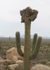
Besides the beautiful rock formations, the other highlight of Bulldog Canyon is the many prolific saguaro.

Almost two miles into Bulldog Canyon, I spied a sign on my left for Deer Tanks Trail. Not having noticed it during my planning, I figured I should at least scout it. 200 yds. up Deer Tanks Trail, is a catchment area. The upper half of the tin-roofed catchment was bone dry. However the overflow box was 100% full of light green, but otherwise clear, water.

After Deer Tanks Trail, FR 10 enters the middle section of Bulldog Canyon. Bearing in mind that the whole hike only accumulates 528 ft. of elevation gain, there are still some steep & rocky sections. Fine gravelled descents are always the trickiest, and I slipped several times. Thankfully, no falls. ⛷

Although FR 10’s high point is near the two mile gate, around five miles is the visual “saddle” of Bulldog Canyon. That is where Fountain Hills, Fort McDowell and the Mazatzal Mountains hove into view.

FR 10 crosses FR 3554 in a wide, sandy, wash. Like every other wash crossing in Bulldog Canyon, it was bone dry. The two miles between FR 3554 and Bush Highway, are car drivable, so not the most enchanting part of the hike. 😑

I arrived at Bush Highway, just after noon. After playing Frogger across the road, I started up a wash towards the Salt River. As I was hiking, I pulled out my phone to let my wife know I was about 15 minutes away from Blue Point Picnic Area. My wife had left me a message that the gate to it was locked, and she was parked next to the highway. Good thing I checked!

Hike Video: https://vimeo.com/671647249
 Flora
 Flora [ checklist ]
[ checklist ]  Saguaro
 Named place
 Named place [ checklist ]
[ checklist ]  Bulldog Canyon  Dome Mountain
wildflower observationwildflower observationwildflower observationwildflower observationwildflower observation
Wildflowers Observation None
Nyet.

dry Bulldog Canyon Dry Dry
I did not witness any water in the canyon bottom, but then I did not search for it either. HOWEVER, the catchment overflow box next to Deer Tanks Trail was 100% full of light green, but otherwise clear water.
_____________________
http://prestonm.com : Everyone's enjoyment of the outdoors is different and should be equally honored.
 
Dec 13 2020
avatar

 Guides 27
 Routes 669
 Photos 12,096
 Triplogs 856

56 male
 Joined Jul 05 2006
 Mesa, AZ
Wolverine Pass TrailPhoenix, AZ
Phoenix, AZ
Hiking avatar Dec 13 2020
DarthStillerTriplogs 856
Hiking4.90 Miles 553 AEG
Hiking4.90 Miles   2 Hrs   24 Mns   2.06 mph
553 ft AEG      1 Min Break
 
1st trip
Partners none no partners
Finally got a chance to take the family out for a hike in the nicer weather. This one is very close by and I hadn't got a chance to hike the Wolverine Pass Trail. We did a loop, starting on Wolverine Pass, headed north on the Bulldog Canyon Road and returned on the Deer Tanks Trail. Looks like we just missed Brian, who started hiking before us and hiked out and back to The Mask. We didn't see all the wildlife he did, either. Once we got back to the trailhead, we took the unmapped trails up into the rock formations and a little closer look at some of those. Short and uneventful hike, but very nice to get out in the morning and do an easy hike with the family. Weather was cool and breezy the entire time.
_____________________
 
Aug 15 2020
avatar

 Guides 27
 Routes 669
 Photos 12,096
 Triplogs 856

56 male
 Joined Jul 05 2006
 Mesa, AZ
Bulldog Cyn to Salt RiverPhoenix, AZ
Phoenix, AZ
Hiking avatar Aug 15 2020
DarthStillerTriplogs 856
Hiking7.97 Miles 1,116 AEG
Hiking7.97 Miles   3 Hrs   58 Mns   2.05 mph
1,116 ft AEG      5 Mns Break
 
Linked   linked  
Partners none no partners
With the even higher than normal temperatures forecasted for today, I wanted to do a hike that was closer to home and get a jump on the earlier part of the day. I also wanted something that didn't have too much elevation gain. I decided on the southern end of the Bulldog Canyon Road, although that ended up having more elevation gain than I had intended. It still wasn't too bad.

I hiked to where I left off several years ago when I hiked the north half (and then some) of the road. On my way back, I noticed that the road was intersected by the track for Idaho Road to The Mask. I hiked to the north end of the wash, but decided not to hike up to The Mask. There was absolutely no sign of any trail, and the steep and sketchy looking terrain didn't look very inviting as the heat started to bear down. On my way back, I noticed a cairn on the side of the wash that marked a single track. I started to follow that for a bit and then saw a brown vinyl marker. I figured this would likely take me back to the road, which it did. It also went back into the wash a few times before it went up over a saddle to the road.

I had intended to try to hike the route back to the Idaho TH and hike the Wolverine Pass Trail over back towards where I parked. However, once back on the road, I was beyond where that intersection was, and was up a bit higher. I decided to take the road back the TH and call it a day. Looks like quite few other trails and ATV roads to explore out here.
_____________________
 
Apr 04 2020
avatar

 Guides 3
 Routes 2
 Photos 1,156
 Triplogs 338

53 male
 Joined Aug 22 2003
 Mesa
Bulldog Cyn to Salt RiverPhoenix, AZ
Phoenix, AZ
Mtn Biking avatar Apr 04 2020
te_waTriplogs 338
Mtn Biking9.00 Miles 350 AEG
Mtn Biking9.00 Miles
350 ft AEG
 no routes
1st trip
Linked   none no linked trail guides
Partners none no partners
Intended to make this a mountain bike / backpacking trek through a shallow canyon, so I rode my bike about 4 miles and stashed it amongst the bushes and proceeded to hike half a mile through a lightly overgrown canyon to the base of some cliffs below Dome mtn. where there is a seasonal waterfall. Unfortunately even though I carried all my overnight gear the only water I saw was a small puddle filled with mosquitoes. Decided to call it, returned to my bike and ride back down Bulldog Canyon to my car. It was a nice ride and saw a few jeeps and razors here and there but not too crowded. Tons of cars along the Bush Highway though. A nice little Nine Mile Excursion into the Goldfields, which never disappoint!
wildflower observationwildflower observationwildflower observationwildflower observationwildflower observation
Wildflowers Observation Moderate
_____________________
squirrel!
 
Feb 18 2020
avatar

 Guides 187
 Routes 989
 Photos 12,068
 Triplogs 864

72 male
 Joined Jun 27 2015
 Tucson, Arizona
Bull Dog Canyon Twin Arches, AZ 
Bull Dog Canyon Twin Arches, AZ
 
Hiking avatar Feb 18 2020
markthurman53Triplogs 864
Hiking14.60 Miles 2,333 AEG
Hiking14.60 Miles   8 Hrs   4 Mns   2.52 mph
2,333 ft AEG   2 Hrs   16 Mns Break15 LBS Pack
 
1st trip
Partners none no partners
Bull Dog Canyon, Twin Arches

My original plan was to hike down Bull Dog Canyon then up over Dome Mountain and then head over to Twin Arches. Got down Bull Dog Canyon but when I started heading up the side canyon that leads up to Dome Mountain Saddle my legs weren’t cooperating. After a couple stumbles on loose rocks and a trip I decided to call this portion off. Must be my body rebelling after all that flat land walking in Lubbock. I decided to head back and follow Bull Dog Canyon back to the Rock House Trail and head up to Twin Arches then return along the Blue Ridge Trail.

On my way down Bull Dog Canyon I followed a route I downloaded which follows the wash at times then over some low lying hills and then along the Bull Dog Canyon 4WD road. On the return trip I just followed the wash, seemed a bit easier and much more interesting. A few pools of water where Bull Dog Canyon makes its turn north but would only drink it if it were treated. Every animal in the area probably visits these pools. The rocks that make these pools possible are quite interesting looking and enhanced by the water polishing them. Once at the junction of the Rock House Trail it was 1 mile to the route to Twin Arches.

Had lunch along the Rock House Trail and then headed up to the arches. Pretty straight forward getting to the Arches even though there is no trail on the western side approach. The return on the eastern side has a trail marked by cairns. The arches are interesting but I think the best part of this portion of the hike were the views of the four Peaks to the east and the Superstitions to the south. I managed to get stung by a bee while coming down from the arches. Just some random bee that my hand must of hit. This was my first bee sting ever, only hurt for a few minutes after removing the stinger. Poor bee gave up his life for no reason. Since I had never been stung before I was thinking this is a hell of a place to find out if you are allergic to bees. I guess I’m not, I’m still here. Once back down on the Rock House Trail I took the Blue Ridge Trail back to where I started. I’m glad I had a GPS route for this portion because there are multiple trails leading in different directions, not sure where they all went. I still managed to make wrong turns because I didn’t check the GPS enough and had to back track.

Nice hike but the mid 70’s temperatures made it a bit warm. The two quarts of water I carried was enough but probably could of used more. Sparse showing of wild flowers, a few that couldn’t wait a couple more weeks.
_____________________
 
Feb 20 2018
avatar

 Guides 7
 Routes 187
 Photos 2,318
 Triplogs 909

74 male
 Joined Dec 10 2016
 Gold Canyon
Bulldog Cyn to Salt RiverPhoenix, AZ
Phoenix, AZ
Hiking avatar Feb 20 2018
DaytripperTriplogs 909
Hiking7.50 Miles 1,100 AEG
Hiking7.50 Miles   4 Hrs   15 Mns   2.14 mph
1,100 ft AEG      45 Mns Break20 LBS Pack
 no routesno photosets
1st trip
Linked   none no linked trail guides
Partners none no partners
Parked at the south bulldog canyon gate and started walking north, turned up into the bulldog canyon wash. Noted the cave and arches,hiked up out of the wash towards panorama peak , did not find any reasonable route this way,steep grade and loose rocks were plentiful.Turned back and hiked to the gate, not much traffic on road today.
_____________________
Navy31 Army13
 
Feb 24 2017
avatar

 Triplogs 72

41 female
 Joined Feb 14 2017
 Prescott Valley,
Bulldog Cyn to Salt RiverPhoenix, AZ
Phoenix, AZ
Hiking avatar Feb 24 2017
sleepybear929Triplogs 72
Hiking2.30 Miles 643 AEG
Hiking2.30 Miles
643 ft AEG
 no routesno photosets
1st trip
Linked   none no linked trail guides
Partners none no partners
Only did 2.3 miles in then back out again. Lots of road traffic. Took dogs, they loved it.
_____________________
 
May 21 2016
avatar

 Guides 5
 Routes 29
 Photos 605
 Triplogs 880

55 male
 Joined Mar 05 2011
 Pocatello, ID
Bulldog Cyn to Salt RiverPhoenix, AZ
Phoenix, AZ
Hiking avatar May 21 2016
WoodsnativeTriplogs 880
Hiking6.70 Miles 600 AEG
Hiking6.70 Miles   3 Hrs   15 Mns   2.06 mph
600 ft AEG
 no routesno photosets
1st trip
Linked   none no linked trail guides
Partners none no partners
_____________________
If you don't run, you rust.
-T. Petty
 
Apr 01 2015
avatar

 Guides 1
 Routes 136
 Photos 22,415
 Triplogs 1,041

77 male
 Joined Feb 28 2003
 Tucson, AZ
Great Western Trail-Tonto FR 10, AZ 
Great Western Trail-Tonto FR 10, AZ
 
4x4 Trip avatar Apr 01 2015
rwstormTriplogs 1,041
4x4 Trip8.00 Miles
4x4 Trip8.00 Miles
 no routes
1st trip
Linked   linked  
Partners none no partners
I had wanted to drive this road for a long time and finally got around to it. Perfect conditions and with it being Spring, there was an abundance of bloom action. :) This is a pretty easy road, with just a few spots where you need the high clearance. As I expected, it is very scenic in there, and it was enjoyable getting some different views of familiar landmarks along the way. When I finished up at Blue Point, I gave @AZLumberjack a call to let him know I was in the area. We met up at Handlebar Pub & Grill in AJ for some beer and conversation.
wildflower observationwildflower observationwildflower observationwildflower observationwildflower observation
Wildflowers Observation Substantial
_____________________
  1 archive
Feb 01 2015
avatar

 Guides 21
 Routes 1,182
 Photos 36,858
 Triplogs 1,570

69 female
 Joined Feb 26 2004
 Phoenix, AZ
Bulldog Canyon Loop - OOPS, AZ 
Bulldog Canyon Loop - OOPS, AZ
 
Hiking avatar Feb 01 2015
tibberTriplogs 1,570
Hiking7.49 Miles 991 AEG
Hiking7.49 Miles   4 Hrs   26 Mns   2.24 mph
991 ft AEG   1 Hour   5 Mns Break
 
Partners partners
desertgirl
Ambika said she had time to do something short so I thot we'd try the other side of the Bulldog Canyon Loop. I checked many other possibilities out there but nothing that would be shorter. I also found a side excursion to the Mask. I loaded this loop up on HAZtraks (still haven't figured out how to get the topo to stick) & Scout II revised edition. I told Ambika we would meet at the Park (as we had planned to meet there a few weeks ago for this loop but chose to go to the Desert Survival Class instead). Somehow she thot Superstition Museum and she thot I had done this Loop with Kelly.

We eventually got together once I got KemoSabe to function after driving to Fry's in AJ from Prospector Park. This cell phone stuff is still a little frustrating to me. Anyway, we had time for the planned hike even though we would be starting an hour later than planned.


We arrived at the trailhead area but had to park short of it due to all the horse trailer activity. It was a very nice morning as we started out and headed west. I showed her where the playground area was up on the Blue Ridge to our east (still editing pics from that awesome hike). We climbed a hill to get a better view of the lingering fog to the south and east of us.

Back down on the road after some ATVers had passed we continued our hike. About four horseback riders came by; one of the horses was wearing ankle high booties instead of shoes. That must be something new because I don't remember that being an option back in my day. I don't know how the booties work if the horse is trotting or galloping :-k . We saw the roof of what we eventually figured out must be an animal water catchment area. We ended up walking past the turn on FR10 but not too far because I looked at my HAZtraks route to make sure so we backtracked THIS time.

Previously on this part of the hike we had views of the Dome Mountains, Four Peaks and Top Hat. Now we were heading north and would be going over a hill (where there was a FS gate) and continuing up down and around on the road. There would be a few vehicles that we would have to pull over for. Part of the road got a bit rutty but I'm sure the drivers enjoyed the challenge. I believe it was not too far from this area that we should have hung a right. I got it in my head that this hike was all road so we stayed on the road ](*,) even though HAZtraks said we were veering north when we should be going more to the east. I just figured the track was off and that we would eventually join back with it. THAT of course did NOT happen. We kept on the road going up and down and admiring the many colors of Dome Mountain on our right.

We had lunch above the wash and picked up some trash to haul out before continuing on hoping that the road would be heading right once we got down toward this declining ridgeline. We ended up going down the wash for a bit but it didn't look promising. Ambika made the call to turn around so we did. I did have a write up with me and after reviewing that a couple times, it did seem we were off course (the write up was the opposite way we were going so it's always a bit more difficult to process that :stop: ). Once back to the road I wanted to climb up to the top of the road to see what we could see (I did a similar thing with Kelly the month before). There was another very steep hill in front of us that is now closed, thankfully, to rec vehicles so we decided to tackle that. I'm a little leery of steep hills right now but it was short.

The views from the top were quite nice :DANCE: . We could see the fog still trying to lift above the Superstitions. Back down the hill we went and headed on FR10. We came to an area that we thot was the turn and way pointed it but it's actually a little further; by the cairn that we totally missed; mostly because I had it in my head that this was a road walk ](*,) . So if you get to the wash with the telephone pole (heading northwestish) you've gone too far. During this hike, it was surprising how hilly (little hills) it was. You think you've hit the last hill and another one shows UP. We didn't really see anybody for the rest of the day after we came down the hill from where the gate is so that was nice.

We ended up doing a longer hike than we planned but it was pretty and I got a better lay of the land. We're looking forward to coming back and really doing the Loop. Of course we finished our day at Los Gringos with some guacamole fresco and other food.

http://youtu.be/OhvO1Z...
_____________________
For me, sometimes it's just as much about the journey as the destination.
Oh, and once in awhile, don't forget to look back at the trail you've traveled.
 
Feb 01 2015
avatar

 Guides 20
 Routes 13
 Photos 3,189
 Triplogs 451

female
 Joined Mar 31 2002
 Chandler, AZ
Bulldog Canyon Loop - OOPS, AZ 
Bulldog Canyon Loop - OOPS, AZ
 
Hiking avatar Feb 01 2015
desertgirlTriplogs 451
Hiking7.49 Miles 991 AEG
Hiking7.49 Miles   4 Hrs   26 Mns   2.24 mph
991 ft AEG   1 Hour   5 Mns Break
 no routes
1st trip
Partners partners
tibber
Moral of the day: Be fully awake and pay attention to what the track says!
Adventures with tibber grows in legend ...
I did not pay attention to what Angela had said as meet up point was -- she said at the Park ( Prospector Park which she had been to recently & I never knew it existed), my brain registers Museum :? and we spend an hour trying to connect in an area with 4G cell reception! (Misbehaving phone + misbehaving mind)

We get off in a tear to burn up the loop trail -- Angela firmly informs me that this is a road hike ...so off we go heads down,feet kicking up dust ...blow way past our turn point (we should have been watching for a trail that takes off from the road at 1.5 miles) and then begin a few hours of road walking, hiking up dead ends ( all pretty & fun), climbing up some really steep ground, seeing what we believed was the mask and hiking some more ....walked up a beautiful wash but then eventually managed to agree we were no longer on the planned hike but just on a hike in the Goldfields. The area was beautiful & it was fun to hike looking back at the Superstitions, a few flowers were starting to pop up. We hauled up a steep hill with some great views, lunched and looked out at "Angela's Playground" and made future plans of an explore day up there and we road hiked our way back to TH .. With it being Superbowl Sunday the ATV crowd had cleared out fast so our walk back was rather tranquil compared to the ATV & horse traffic of the morning

We stop in for the usual Los Gringos fix and part ways ...for me only to come home & get riveted by the rather nail biter of a finish for the game! :y: Fitting end to a day of unusals...
 Culture
 Culture [ checklist ]
[ checklist ]  Balloon
wildflower observationwildflower observationwildflower observationwildflower observationwildflower observation
Wildflowers Observation Isolated
Desert Marigold, Brittle Bush, Poppies and a few assorted belly flowers
_____________________
 
Dec 25 2013
avatar

 Guides 177
 Routes 249
 Photos 10,213
 Triplogs 2,215

74 male
 Joined Feb 12 2002
 Gold Canyon, AZ
Bulldog Cyn to Salt RiverPhoenix, AZ
Phoenix, AZ
Hiking avatar Dec 25 2013
AZLOT69Triplogs 2,215
Hiking8.30 Miles 643 AEG
Hiking8.30 Miles
643 ft AEG
 no routesno photosets
Linked   none no linked trail guides
Partners none no partners
Nice day, a few others out there.
_____________________
It's best for a man to remain silent and be thought a fool, than to open his mouth and remove all doubt.
--Mark Twain
 
Nov 11 2012
avatar

 Guides 1
 Routes 38
 Photos 3,193
 Triplogs 467

55 male
 Joined Jul 26 2008
 San Tan Valley,
Bulldog Cyn to Salt RiverPhoenix, AZ
Phoenix, AZ
Hiking avatar Nov 11 2012
TheNaviG8RTriplogs 467
Hiking8.30 Miles 630 AEG
Hiking8.30 Miles
630 ft AEG
 
no photosets
1st trip
Linked   none no linked trail guides
Partners none no partners
Had the wife drop me off at the Southern TH and off I went. I called her with approximately 1 mile to go and she left home to pick me up at the Northern Bulldog Canyon TH. It was a beautiful morning to be out hiking.
_____________________
 
average hiking speed 2.14 mph
1, 2  Next

WARNING! Hiking and outdoor related sports can be dangerous. Be responsible and prepare for the trip. Study the area you are entering and plan accordingly. Dress for the current and unexpected weather changes. Take plenty of water. Never go alone. Make an itinerary with your plan(s), route(s), destination(s) and expected return time. Give your itinerary to trusted family and/or friends.

helpcommentissue

end of page marker