username
X
password
register
for free!
help
ArticlesGuidesRoutes
 
Photosets
 
 Comments
triplogs   photosets   labels comments more
Tortilla Super Loop - 8 members in 17 triplogs have rated this an average 3.8 ( 1 to 5 best )
17 triplogs
login for filter options
Feb 24 2024
avatar

 Guides 94
 Routes 840
 Photos 22,055
 Triplogs 1,993

52 male
 Joined Sep 18 2002
 Tempe, AZ
Holy Bacon Peter, AZ 
Holy Bacon Peter, AZ
 
Backpack avatar Feb 24 2024
chumleyTriplogs 1,993
Backpack25.44 Miles 4,298 AEG
Backpack25.44 Miles2 Days         
4,298 ft AEG
 no routes
1st trip
Needed to get outside again. A warm Feb weekend, with temps in the mid 70s was softened by cloudiness both Sat and Sun.

Bland scenery on Hoolie with the fire scar taking its toll, though the views were distant. Red Tanks through upper La Barge is rough but a highlight of scenery on the loop. Dutchman is a highway in this stunning supes canyon.

FOTG had claimed the best campspot along the creek, so we settled for option 2 not wanting to encroach on a romantical weekend in the woods. ;)

We took an afternoon jaunt up Trap, which was a real treat, and one I'd like to explore the rest of the way. Unfortunately, sunset forced a turnaround and we headed back to camp for the night. A full moon lit up the sky and temps dropped to 41, about 10 lower that we had expected, but somehow we managed to survive the night.

FOTG stopped by for a few minutes in the ayem on his way out before we headed our own way down toward Charley and Peter. Climbing up to the mesa reintroduced fire damage and the mesa was a mess. The catclaw is prolific and the tread is tough to follow in some places. The five red-spray-painted rocks along the way were instrumentally important in finding the way. :-k :doh:

The last two miles along upper Tortilla is a treat with cool geology and plenty of water right now. On the drive out we passed a Jeep Liberty heading up the 213, and I'm pretty sure they were on an intentional one-way trip. Best wishes to those folks and whoever's car they stole. :sweat:
 Named place
 Named place [ checklist ]
[ checklist ]  LaBarge Spring

water 1 out of 5water 2 out of 5water less than maxwater less than max LaBarge Spring Quart per minute Quart per minute
No need for the spring, as the creek was flowing nicely. But there was nice flow from the pipe and a full springbox. It's an overgrown mess to get up to it though, and not easy to find if you don't know it's there.

water 1 out of 5water 2 out of 5water less than maxwater less than max Oak Spring Quart per minute Quart per minute
Didn't go up to the source, but there was a visible flow in the drainage at the trail crossing.

water 1 out of 5water 2 out of 5water less than maxwater less than max Peters Mid-Upper Along Trail Light flow Light flow
Peters was flowing the entire length

dry Tortilla Well Dry Dry
No sign of water at the well or trough. Plenty in the adjacent creek however.

water 1 out of 5water 2 out of 5water less than maxwater less than max Trap Canyon Light flow Light flow

water 1 out of 5water 2 out of 5water 3 out of 5water less than max Trap Canyon Spring Gallon per minute Gallon per minute
Didn't find the actual spring source ... plenty of flow in the canyon.

water 1 out of 5water 2 out of 5water less than maxwater less than max Upper LaBarge Box Canyon Light flow Light flow

water 1 out of 5water 2 out of 5water less than maxwater less than max Whiskey Spring Canyon Light flow Light flow
_____________________
I'm not sure what my spirit animal is, but I'm confident it has rabies.
  3 archives
Dec 16 2023
avatar

 Guides 3
 Routes 633
 Photos 8,249
 Triplogs 605

54 male
 Joined Apr 13 2011
 Gilbert, AZ
Tortilla Super LoopPhoenix, AZ
Phoenix, AZ
Hiking avatar Dec 16 2023
ddgrunningTriplogs 605
Hiking26.60 Miles 3,720 AEG
Hiking26.60 Miles   10 Hrs   12 Mns   2.75 mph
3,720 ft AEG      31 Mns Break
 
1st trip
Route Scout Route Recorded  on Route Scout | Pop | Map | Popup | MapDEX
I didn’t have the rock crawling skills to drive to the Peters trail TH, so I parked and started from the Tortilla TH, which added another 7 miles round trip.

Peters Trail—Now I know where the term “peters out” comes from. 😄 This trail does so early and often. Nature is reclaiming this one, and in my view, having a gps track is essential. There were periodic cairns, but standing at the cairn, it was often difficult to figure out which direction to go from there. Most of this trail is pretty blah by Superstition standards, with the exception of the initial jaunt through a brief canyon, and then on the back end, as you descend to the Dutchman junction.

From there, I tacked on a quick side trip to Charlebois Spring, which was showing its fall colors and full of water, per usual. Met my first fellow traveler at the spring, a solo backpacker on his second night. We visited and he graciously guided me to the petroglyph panel. Cool to see.

From there, I headed down Dutchman and the first section of Red Tanks, both of which were smooth sailing. Enjoyed some fun fall colors at the springs.

Upper La Barge Box was a highlight. Overgrown in spots but not too bad as far as route finding goes.

Hung a left at the Hoolie Bacon junction and was concerned about a repeat of the Peters Trail route finding issues. But, while the trail is indistinct in many places and a bit brushy here and there, it is very well cairned and route finding was rarely an issue. Not particularly scenic though.

Finished the loop, and with the 3.5 mile road walk left, I knew I’d be fighting for daylight. Enjoyed a lovely sunset and threw on the headlamp for the last half mile.

Tons of solitude to be had on this loop. Long pants are a must, to keep the lacerations to a minimum. On that note, don’t wear clothes that you care about, as the desert pokies are unavoidable and will extract their cheese-grater dues.

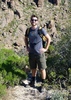
A full day in the Supes!
_____________________
  2 archives
Nov 30 2022
avatar

 Guides 59
 Routes 1,100
 Photos 1,191
 Triplogs 1,290

male
 Joined Jan 01 2023
 Arizona
Tortillita, AZ 
Tortillita, AZ
 
Hiking avatar Nov 30 2022
pseudalpineTriplogs 1,290
Hiking24.98 Miles 4,188 AEG
Hiking24.98 Miles   10 Hrs   23 Mns   2.54 mph
4,188 ft AEG      34 Mns Break
 
1st trip
Sarcastically diminutive title for a relentlessly brutal and endearing route. Almost every one of the linked trail sections are all about The Rippin' and the Tearin', just not in the same context as Hedo Rick! Unless the catclaw rips ones lip or tears ones sack. :o You'll also likely have some cactus spines that one of your significant others can help remove afterwards. Nitty Gritty Slitty Kitty!
 Flora
 Flora [ checklist ]
[ checklist ]  Saguaro
 Named place
 Named place [ checklist ]
[ checklist ]  La Barge Box  La Barge Canyon
  19 archives
Feb 19 2021
avatar

 Routes 154
 Photos 1,505
 Triplogs 266

31 male
 Joined Jun 02 2019
 Phoenix, AZ
Tortilla Mountain Loop, AZ 
Tortilla Mountain Loop, AZ
 
Hiking avatar Feb 19 2021
LJWTriplogs 266
Hiking23.12 Miles 5,081 AEG
Hiking23.12 Miles   8 Hrs   51 Mns   2.85 mph
5,081 ft AEG      45 Mns Break
 
1st trip
Route Scout Route Recorded  on Route Scout | Pop | Map | Popup | MapDEX
Had originally planned on Black Mountain but switched on a whim. Started around 7:30 and went counterclockwise starting with Tortilla Mountain.

Road walk for a mile up 213 before a couple guys in an off-roader offered me a ride to the trailhead. Declined, and changed my mind about going all the way down the road. Had a look at the grassy ridgelines to the west toward Tortilla Mountain and decided to cut corners on the loop and go for that summit instead. Left the road and went down to the creek and then up. It's steep, but there's no bushwhacking on the slopes and ridges, only crossing the two drainages.

Eventually made my way to the Tortilla Peak Ridgeline and the fun started. Good scrambling and some sense of exposure, particularly where the ridgeline is broken north of the peak. Distant views. Very poor man's Brown's - Brother traverse. Best part of the hike. Summit is up high off the ridgeline something like Cathedral Rock in the Catalinas, only no rope or reason to have one.

Have a hard time enjoying a summit not knowing how I'll get down. Did no research in advance, and on the maps the west side of the peak looks less cliffy. Didn't stay long before heading to the little subpeak to the south and working my way down. Cliffed out a few times, and I had to head farther south than planned, toward the drainage that cuts E/W across Tortilla Mountain. Ended up hopping down the creek to Peter's Canyon and found the trail.

Peter's trail toward Black Mountain and thought what's the point in doing that. Looks like more of an achievement from Charlebois. Saw the only people of the day on Peter's trail. They were running from Canyon Lake and had dropped a car at Tortilla TH. Had a brief chat during which they explained they knew which car was mine at the TH and mentioned I should go to Herman's Cave. Didn't end up going, sorry guys. Thanks for not keying my car.

Dutchman, Red Tanks, Hoolie Bacon. Only water I remember was at Larbarge Spring, in La Barge Creek by Whiskey Spring Canyon, and in the Box.
wildflower observationwildflower observationwildflower observationwildflower observationwildflower observation
Wildflowers Observation Isolated
Few at higher elevation

water 1 out of 5water 2 out of 5water 3 out of 5water less than max LaBarge Spring Gallon per minute Gallon per minute

water 1 out of 5water 2 out of 5water less than maxwater less than max Upper LaBarge Box Canyon Light flow Light flow
  3 archives
Jan 26 2018
avatar

 Routes 1
 Photos 356
 Triplogs 31

43 male
 Joined Nov 23 2007
 Tempe, AZ
Tortilla Super LoopPhoenix, AZ
Phoenix, AZ
Backpack avatar Jan 26 2018
bballardTriplogs 31
Backpack23.00 Miles 3,500 AEG
Backpack23.00 Miles2 Days   12 Hrs      
3,500 ft AEG
 no routes
1st trip
Linked   none no linked trail guides
Partners none no partners
I came back for some unfinished business on these trails after getting rained out a few years ago. An incredible, remote backpacking loop in the Superstitions! Friday night was a late night start hiking FR 213 which put me camping at the Cedar Basin area on the Hoolie Bacon Trail. From there the next day it was following the loop clockwise, hitting the very scenic view at Horse Ridge saddle before dropping into Horse Camp Basin. After joining the Red Tanks trail, the upper LaBarge Box never disappoints. Then it was cruising along the dry stream bed- hardly a drop of water to be seen in any of the creeks which is crazy for this time of year. LaBarge and Charlebois are thankfully dependable of course.

After topping off, I huffed it up to a high knob on the Peters Trail to make my second night camp with a wonderful panoramic view centered on Bluff Springs Mt. A fierce windstorm complimented the very full moon that night. Then it was off to explore Peter's canyon for the first time. This is a beautiful experience in the Supes, offering a lot of variety in terrain. Backpacking solo allows one a great chance to reflect and take in the subtle details of the environment. Only one group of three gentlemen were encountered. Highly recommended!

dry Brads Canyon Dry Dry


water 1 out of 5water 2 out of 5water 3 out of 5water 4 out of 5 Charlebois Spring Gallon + per minute Gallon + per minute


water 1 out of 5water 2 out of 5water 3 out of 5water less than max LaBarge Spring Gallon per minute Gallon per minute


water 1 out of 5water less than maxwater less than maxwater less than max Peters Mid-Upper Along Trail Pools to trickle Pools to trickle
_____________________
 
Dec 27 2016
avatar

 Photos 281
 Triplogs 222

45 male
 Joined Aug 03 2008
 Chandler, AZ
Tortilla Super LoopPhoenix, AZ
Phoenix, AZ
Hiking avatar Dec 27 2016
knmurphyTriplogs 222
Hiking17.80 Miles 3,500 AEG
Hiking17.80 Miles   8 Hrs   24 Mns   2.38 mph
3,500 ft AEG      55 Mns Break
 no routesno photosets
1st trip
Great hike, perfect weather today. There is water everywhere, all the creeks are flowing.
_____________________
 
Feb 06 2016
avatar

 Guides 6
 Routes 183
 Photos 5,612
 Triplogs 1,647

male
 Joined Mar 12 2004
 Scottsdale, AZ
Tortilla Super LoopPhoenix, AZ
Phoenix, AZ
Hiking avatar Feb 06 2016
John9LTriplogs 1,647
Hiking23.76 Miles 4,147 AEG
Hiking23.76 Miles   10 Hrs   25 Mns   2.66 mph
4,147 ft AEG   1 Hour   30 Mns Break
 no routesno photosets
1st trip
Met up with Kyle for another trek on the Tortilla Super Loop. This is our third time making this loop and probably not the last. We parked right off the 88 hwy around 7:20am and started hiking the road. This part flies by and we hit the JF trail opting for a clockwise loop. The hike up Hoolie Bacon went well and we dropped down to Red Tanks Trail. We made good time as the miles poured by and took our lunch at La Barge Spring. Here we talked to a pair of guys making a loop from Peralta and were exiting the Whiskey Spring Trail. They were asking how much time they had back to the trailhead. I guessed 3-5 hours. We continued on and headed up the Peters Trail. This portion of the hike started to take it's toll on us. We were both getting tired and route finding kept our heads on a swivel. We took a break at a creek and filtered some water. From there we had one more small climb and then all downhill back to the Tortilla TH. Some trail maintenance has been completed through here and made for quick travel. Once back to the TH we flew down the road and were back to the vehicle around 5:40pm. This was a long day but I'm glad we did it. This is a great hike that doesn't get a lot of traffic. Thanks Kyle for suggesting this one and driving.
_____________________
 
Feb 06 2016
avatar

 Routes 67
 Photos 2,708
 Triplogs 755

89 male
 Joined Mar 28 2008
 Phoenix, AZ
Tortilla Super LoopPhoenix, AZ
Phoenix, AZ
Hiking avatar Feb 06 2016
Tough_BootsTriplogs 755
Hiking23.40 Miles 3,869 AEG
Hiking23.40 Miles
3,869 ft AEG
 no routesno photosets
1st trip
Our third time doing this loop and I always forget how tough Peters Trail can be-- every time I thought the climbing was over there was more climbing. There's tons of water out there still. It was a beautiful day for a death march and we only saw a handful of people.
_____________________
 
Feb 05 2016
avatar

 Guides 13
 Routes 38
 Photos 1,651
 Triplogs 577

60 male
 Joined Nov 15 2005
 Jackson, CA
Tortilla Super LoopPhoenix, AZ
Phoenix, AZ
Hiking avatar Feb 05 2016
toddakTriplogs 577
Hiking22.00 Miles 4,500 AEG
Hiking22.00 Miles   9 Hrs   30 Mns   2.32 mph
4,500 ft AEG
 no routesno photosets
1st trip
Tough loop, went clockwise, with a side out-and-back on WST #238 (because it was there and I hadn't been). Upper La Barge box is very scenic. Peter's Trail follows a nice route but most of it is in pretty bad shape. Plenty of water everywhere. Mountain biked between Hwy 88 and the trailhead.
_____________________
  1 archive
Mar 22 2014
avatar

 Guides 6
 Routes 183
 Photos 5,612
 Triplogs 1,647

male
 Joined Mar 12 2004
 Scottsdale, AZ
Hoolie Bacon - Peters Trail LoopPhoenix, AZ
Phoenix, AZ
Hiking avatar Mar 22 2014
John9LTriplogs 1,647
Hiking23.25 Miles 4,417 AEG
Hiking23.25 Miles
4,417 ft AEG
 
Big loop with Kyle. Went counter clockwise and saw six people all day.
_____________________
 
Nov 02 2013
avatar

 Routes 5
 Photos 58
 Triplogs 46

49 male
 Joined Apr 18 2002
 Phoenix, AZ
Tortilla Super LoopPhoenix, AZ
Phoenix, AZ
Hiking avatar Nov 02 2013
rehlersTriplogs 46
Hiking17.80 Miles 3,500 AEG
Hiking17.80 Miles   10 Hrs   15 Mns   1.74 mph
3,500 ft AEG
 no routesno photosets
1st trip
Partners none no partners
I have wanted to get this loop in for years now. Finally with a Jeep it was possible without the extra 6 miles along the road. Ran into Hike Arizona member Larry on the drive back to the road and gave him a lift back to the TH. He looked like he got into a fight with a catclaw bush and lost .. badly :)

I did this counter clock wise, and I'd probably recommend it that way. First, the Peter's Trail is harder to follow and seems like it would be steeper ascent coming from the other way.

Trail Conditions
Peter's Trail - On many parts of the trail you feel like you are right on the edge of losing it, but can just follow. It wasn't too overgrown on average, except near the area around Peter's Canyon.
Dutchman - Easy to follow and not overgrown. Love the springs area with all the trees, it is like walking into another world for that short section.
Red Tanks - Surprisingly easy to follow for the most part. Not too much bushwhacking
Hoolie Bacon - Again, pretty easy to follow and not much overgrowth.
_____________________
 
Jan 19 2013
avatar

 Guides 6
 Routes 183
 Photos 5,612
 Triplogs 1,647

male
 Joined Mar 12 2004
 Scottsdale, AZ
Hoolie Bacon - Peters Trail LoopPhoenix, AZ
Phoenix, AZ
Hiking avatar Jan 19 2013
John9LTriplogs 1,647
Hiking23.00 Miles 4,255 AEG
Hiking23.00 Miles   9 Hrs   52 Mns   2.68 mph
4,255 ft AEG   1 Hour   18 Mns Break
 
Kyle and I headed out to Tortilla with plans to make the Hoolie Bacon - Peters Loop. We started driving up the road and I was not crazy about the obstacles. We had a quick look and decided to dump the jeep and wrack up a bunch of miles.

The walk up the road flew by. We found ourselves at the true trailhead within the hour. We connected on JF to Hoolie Bacon and followed the trail down towards Red Tanks. Once on the Red Tanks we proceeded west. I really enjoy this portion of trail. Along the way we crossed paths with Fricknaley & Azdesertfather. We continued on and had lunch at La Barge Spring. From there we continued north and ran into more HAZ members, Slowandsteady and BiFrost. We had a nice chat and then continued.

Once on Peters Trail we started making the climb up. Our progress slowed but we pushed on. Along Peters we passed four separate backpacking groups. Most of them were heading to Charlebois. After a while we returned to the parking area and then hiked back on the road and back to the jeep.

This was a long day but well worth. I'm really glad we checked out this area of the Supes and I didn't mind the extra mileage. I look forward to returning to this area again someday.
_____________________
 
Mar 20 2011
avatar

 Guides 1
 Routes 148
 Photos 9,925
 Triplogs 3,654

63 male
 Joined Apr 02 2005
 Mesa, AZ
Tortilla Super LoopPhoenix, AZ
Phoenix, AZ
Hiking avatar Mar 20 2011
Tortoise_HikerTriplogs 3,654
Hiking18.70 Miles 3,922 AEG
Hiking18.70 Miles   8 Hrs   53 Mns   2.11 mph
3,922 ft AEG
 no routes
1st trip
Partners partners
wallyfrack
Wally was nice enough to take me down forest road 213 so I could do a couple of the many trails in the Supes I haven't done yet.The road lived up to it's fame.Wally would be hiking with only a couple hours sleep so I could stay within a quarter mile of him. :D We went out Peters Trail and back Hoolie Bacon.Lots of places to get water in the creeks.We checked out Peter's Mesa,The Wall,Charliebois Spring and the Spanish Map.We saw a couple Whitetail Deer and a Diamondback.Lots of great views and the weather was overcast and pleasent.Thanks for driving Wally!!Great weather,Great Hike,Great company! :D
 Culture
 Culture [ checklist ]
[ checklist ]  HAZ Rides
_____________________
Tortoise Hiking. Stop and smell the Petrichor.
 
Mar 20 2011
avatar

 Routes 93
 Photos 7,758
 Triplogs 1,691

64 male
 Joined Mar 11 2003
 AZ
Tortilla Super LoopPhoenix, AZ
Phoenix, AZ
Hiking avatar Mar 20 2011
wallyfrackTriplogs 1,691
Hiking18.70 Miles 3,922 AEG
Hiking18.70 Miles   8 Hrs   53 Mns   2.11 mph
3,922 ft AEG
 
Linked   none no linked trail guides
Partners partners
Tortoise_Hiker
Denny wanted to complete some new trails and I wanted another run down FR213. The drive was fun as always. Peters trail is in ok shape. It was easy to follow and not as overgrown as I remembered it to be in the past. WE stopped to see the lawn chairs I found in 2007 were still around and yes they are. The fauna was out as we saw a red-tailed hawk two white-tailed deer and a diamondback to spice up the trail. The hazy sky kept the sun at bay and with the breeze going it stayed nice all day. We added a side trip up Peters Mesa and another to Charlebois Spring for adventure. We also found a note at the Hoolie Bacon/JF intersection and fowarded the message. Nice day on he trail. Thanks for coming out Denny.
_____________________
  2 archives
Mar 08 2009
avatar

 Guides 3
 Routes 4
 Photos 8,687
 Triplogs 931

46 male
 Joined Mar 28 2005
 Gilbert, AZ
Tortilla Super LoopPhoenix, AZ
Phoenix, AZ
Hiking avatar Mar 08 2009
VapormanTriplogs 931
Hiking24.30 Miles 3,800 AEG
Hiking24.30 Miles   12 Hrs   15 Mns   1.98 mph
3,800 ft AEG
 no routesno photosets
1st trip
Partners none no partners
This was a redux of an attempt to hike this loop last winter that ended up being a Peters Trail-Peters Canyon-Thumbing a ride from Tortila Flats back to the Tortilla TH. :lol:

I of course walked FR213 into the THs and did this loop clockwise this time to avoid the mistake last time of following Peters Canyon too long... Hoolie Bacon is in pretty good shape and only lost the trail a couple times. I brought a pair of hand pruners this time and cleaned both Hoolie and the Red Tanks trails up a bit, but didn't have enought time to do anything on the slightly overgrown Peters trail... This loop is thru one of the less scenic sections of the Supes, but it certainly has it moments going around Herman Mountain and down thru the upper La Barge Box, hiking along La Barge Creek towards Charlebois, hiking towards Peters Mesa and viewing upper Charlebois & Music Canyons, and Peters Canyon just south of Tortilla Mountain. I had two rattlers coil up on me only 3-4 feet away, which scared the crap out of me. :o I also saw two deer near Peters Canyon and a coyote on FR213 as I hiked out during dusk. Most of the trails are easy enough to follow, but that Peter trail needs the most amount of work trimming back the plant life and making more cairns.
wildflower observationwildflower observationwildflower observationwildflower observationwildflower observation
Wildflowers Observation Light
_____________________
Yea, canyoneering is an extreme sport... EXTREMELY dramatic!!! =p
 
Dec 24 2007
avatar

 Guides 107
 Routes 249
 Photos 2,067
 Triplogs 514

male
 Joined Nov 18 2005
 Phoenix, AZ
Tortilla Super LoopPhoenix, AZ
Phoenix, AZ
Hiking avatar Dec 24 2007
nonotTriplogs 514
Hiking
Hiking
 
no photosets
1st trip
Linked   none no linked trail guides
Partners none no partners
Logged under Peters Mesa
_____________________
http://hikearizona.com/garmin_maps.php

Hike Arizona it is full of sharp, pointy, ankle-twisting, HAZmaster crushing ROCKS!!
Hike Arizona it is full of sharp, pointy, shin-stabbing, skin-shredding plants!
Hike Arizona it is full of striking, biting, stabbing, venomous wildlife!
 
May 05 2007
avatar

 Routes 93
 Photos 7,758
 Triplogs 1,691

64 male
 Joined Mar 11 2003
 AZ
Tortilla Super LoopPhoenix, AZ
Phoenix, AZ
Hiking avatar May 05 2007
wallyfrackTriplogs 1,691
Hiking24.30 Miles 3,500 AEG
Hiking24.30 Miles   11 Hrs      2.21 mph
3,500 ft AEG
 
Partners none no partners
I decided to take advantage of a cool day with a nice breeze and hike the superstitions one more time before the heat rolls in. The weather was perfect. Since I was in a car I parked at the end of FR213 and hiked the 3.1 miles in to the JF trailhead. The trail is lightly used but was easy enough to follow. A few times I got off trail but after backing up a few feet the route was easy to find. The Hoolie Bacon Trail starts about .8 miles from the JF TH and the intersection is marked with signs. The trail gradually gains elevation as it winds through the desert. I saw two white tailed deer but was unable to get photos as they pranced off and stopped it the distance to look back. I did a little side trip into the north end of Trap Canyon but turned back when the bouldering got tricky. I continued on to the Red Tanks trail and headed around Herman's mountain into Upper LaBarge Box. The saguaros are tall and the terrain is wild. I took another side trip up to Hermans Cave and then back down the Red Tanks trail to the Dutchman Trail. Once on the Dutcman trail I decied to check out LaBarge spring which was flowing and the trough was full. I noticed a friendly diamond back as I realized I was just previously standing right next to it but it never rattled or seemed upset in anyway. I took a few photos and left the spring. I pasted the intersection with Peters trail and went into Charlebois Canyon for a look around. I was running out of steam so I cut this trip short and headed back to Peters trail. Once on Peters Mesa the turn around seemed too familiar so I back tracked just to make sure I was on the right trail. The trails were in decent shape and the bush was fairly tame. I wore long pants and sleeves so my wounds were very light. The side trips and road hiking added about 8.2 miles to my route. I was glad to finally make it to FR213 and finish the last 3.1 miles back to the car.
_____________________
  2 archives
average hiking speed 2.36 mph

WARNING! Hiking and outdoor related sports can be dangerous. Be responsible and prepare for the trip. Study the area you are entering and plan accordingly. Dress for the current and unexpected weather changes. Take plenty of water. Never go alone. Make an itinerary with your plan(s), route(s), destination(s) and expected return time. Give your itinerary to trusted family and/or friends.

helpcommentissue

end of page marker