|
| | | |
| |
|
| Hiking | 8.50 Miles |
1,387 AEG |
| | Hiking | 8.50 Miles | 3 Hrs 30 Mns | | 2.43 mph |
| 1,387 ft AEG | | | | |
|
|
| |
| Partners |
|
none
[ show ]
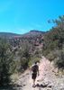
| no partners | | The century plants were in glorious bloom through the hike, with the best example right in the parking lot at the Jordan Road Trailhead. (As it is referred to on Google Maps; signage at the trailhead refers to it as the Jim Thompson Trailhead.) After taking a few pictures, I headed out, hiking clockwise.
After a brief misdirection on Jordan Trail, I got on Cibola Pass Trail. The “pass” itself, is barely 125 ft. above surrounding terrain. (Which makes the saddle behind my house look like the Khyber Pass.) The most mitten-like view of The Mitten, came very quickly, while still on its easterly side, before reaching the top of Cibola Pass.
The best views of Morning Glory Spire some as Cibola Pass Trail reconnects to Jordan Trail, where the route crosses slickrock as it approaches the Devils Kitchen Sinkhole. Even when on normal dirt trail, other than a few century plants, flowers were quite rare.
After checking out the sinkhole, I made my first planned diversion, heading west on Teacup Trail, which starts as jeep trail. According to the map, Teacup heads southwest, fairly straight for a half mile before Skidmark Trail splits off from it. Instead, Teacup was perhaps the twistiest trail I’ve ever been on. Given all the mountain bike tracks, Teacup had obviously been rerouted and optimized for MTBs. (More twists = more gradual elevation gain.) It was actually a mile to reach the intersection, which is located at a small boulder pile. Skidmark Trail is not obvious, but it is there. You just have to look close. As the views of Coffee Pot Rock were no better up close, and time was a factor, I headed back to Devils Kitchen.
Whereas from Teacup, Coffee Pot looks just the face of a cliff, from Soldier Pass Trail, it instead looks like a series of tilting dominoes. You can see Coffee Pot is composed of four or five separate spires.
The most scenic part of Soldier Pass Trail is the Seven Sacred Pools, a series of pothole cascades in a short gulley worn through the slickrock. The water was not flowing, but lining the Seven Sacred Pools up with Coffee Pot Rock makes for a great photograph, if shot in vertical mode. (As I found on Google image search, I was not the only one to have this realization.)
Just before the trail begins climbing to the top of Soldier Pass, I instead turned up a side trail towards the Soldier Pass Arches. Soon after that, I bailed. I was close to the arches, but keeping an eagle eye on my time, and it was getting short. I had started at about 7:40 a.m., with a hard end-ex of 12:15 p.m. It was already 10:50 a.m. and I had almost three miles to go.
I soon connected to Brins Mesa Trail, and booked across Brin Mesa’s burn area. Most of the trees were killed off in 2006, while the shrubbery have recovered, but the few survivors provided welcome relief. (The temp when I started was a pleasant 75, with a high -- at 3pm -- of 92 predicted, but it was already around 95!)
The descent down Brin Mesa’s east slope is across a half mile of steep slick rock, before re-entering the tree line. With .75 miles to go, I took another quick break, texting ahead to my always patient wife to let her know I would be back at the Jordan Road Trailhead in about 15 minutes. In the end, it took my old pumpkin about 20 minutes, despite what felt like hauling pumpkin. I arrived about 12:25, had a quick pee, rehydrated, threw my gear in the back, and off we flew to our lunch date up Oak Creek Canyon at Indian Gardens.
Hike Video: [ youtube video ] |
|
Wildflowers Observation None
Could count 'em on one hand. |
|
| _____________________
| http://prestonm.com : Everyone's enjoyment of the outdoors is different and should be equally honored. |
| | |
|
|
|
 Route Editor


 . Perfect weather, awesome hike, not too hard, not too easy