username
X
password
register
for free!
help
ArticlesGuidesRoutes
 
Photosets
 
 Comments
triplogs   photosets   labels comments more
Tom's Thumb TH to Gateway TH - 7 members in 13 triplogs have rated this an average 3.4 ( 1 to 5 best )
13 triplogs
login for filter options
Sep 16 2024
avatar

 Guides 59
 Routes 1,100
 Photos 1,191
 Triplogs 1,290

male
 Joined Jan 01 2023
 Arizona
McDowell Mountains / Tom's ThumbPhoenix, AZ
Phoenix, AZ
Climbing avatar Sep 16 2024
pseudalpineTriplogs 1,290
Climbing16.84 Miles 3,897 AEG
Climbing16.84 Miles   5 Hrs   36 Mns   3.17 mph
3,897 ft AEG
 
•• West Corner Solo 4th
Route Scout Route Recorded  on Route Scout | Pop | Map | Popup | MapDEX
No nutrition waist channels were signed into the summit register for 05-May,'18, so the Linked trail guide one did for that day is a lie. It would be fun to research how many more they've embellished. :-s I digress, but at 5:41am the mindless greyhounds all crushed onto the Gateway Loop Trail, so I chose the more mellow Desert Park start. The rat race was avoided because none of them were seen again for the rest of my hike and double T solo. The East End ascent was hot and humid, then some nice breezes and cloud cover helped immensely. I need to remember that the Tom's Thumb TH doesn't have water because two liters was slightly inadequate. :sweat:
 Named place
 Named place [ checklist ]
[ checklist ]  Tom's Thumb
  18 archives
Jan 17 2024
avatar

 Guides 116
 Routes 337
 Photos 11,399
 Triplogs 894

63 male
 Joined Dec 20 2010
 Sunnyslope, PHX
Tom's Thumb TH to Gateway THPhoenix, AZ
Phoenix, AZ
Hiking avatar Jan 17 2024
kingsnakeTriplogs 894
Hiking7.74 Miles 2,565 AEG
Hiking7.74 Miles   3 Hrs   30 Mns   2.21 mph
2,565 ft AEG
 no routes
1st trip
Linked   linked  
Partners none no partners
I wanted to avoid the official Maricopa Trail route, as I’d hiked all the component trails before, some multiple times. The official route is a 1,300 ft. climb to Windgate Pass, then miles of boring flats. Instead, I hiked the Tom’s Thumb Trail alternate, whose elevation gain is one long, steady, climb. After today, I consider myself to have done the full official Maricopa Trail route, even if not all at once. 😇

Gateway Loop Trail and Windgate Pass Trail were mostly in shade due to overcast, and the shadow cast by McDowell Peak. It was quite chilly.

At least in winter, the main attraction is the many saguaro. It is not the slowly encroaching mega mansions of Silverleaf — including Arizona’s most expensive home, "Altitude".

At the 2¾ mile mark, I turned left off the official Maricopa Trail, onto Tom’s Thumb Trail. It's a steady climb near the canyon bottom until TT 11, at the 4¼ mile mark. There, the trail gets much steeper, switchbacking many times over the course of the next mile.

Not many people, though one couple passed me going up & down. 😆

I ate lunch at TT9. (A to-go BLT from The Breakfast Joynt on Bell & Thompson Peak.)

On either side of the trail's high point (3,795 ft.), it was a bit muddy, and there were small patches of icey snow.

Past the junction with East End Trail, Tom’s Thumb Trail passes through a boulder field full of rock climbing locations such as “Glass Dome”, it begins descending in earnest, 900 ft. in just over a mile to Gateway Trailhead. From Tom’s Thumb on down, it is quite crowded.

I’ve now completed 210.85 miles of Maricopa Trail. Three more segments to go!

Rumble Video: https://rumble.com/v48ee90-maricopa-tra ... lhead.html
Vimeo Video: https://vimeo.com/904968722
 Culture
 Culture [ checklist ]
[ checklist ]  HAZ - Selfie  HAZ Food
 Named place
 Named place [ checklist ]
[ checklist ]  East End  Tom's Thumb
 Meteorology
 Meteorology [ checklist ]
[ checklist ]  Snow
wildflower observationwildflower observationwildflower observationwildflower observationwildflower observation
Wildflowers Observation None
Zilch. Zero. Nada.
_____________________
http://prestonm.com : Everyone's enjoyment of the outdoors is different and should be equally honored.
 
Sep 24 2022
avatar

 Guides 2
 Routes 31
 Photos 902
 Triplogs 50

male
 Joined Sep 19 2020
 Phoenix
Tom's Thumb TH to Gateway THPhoenix, AZ
Phoenix, AZ
Hiking avatar Sep 24 2022
ScottHikaTriplogs 50
Hiking13.00 Miles
Hiking13.00 Miles
15 LBS Pack
 no routes
1st trip
Linked   none no linked trail guides
Partners none no partners
I hiked Inspiration Point from Gateway with friends and on a whim, solo to Toms Thumb and back. Toms Thumb of course was named after Tom Kreuser the rock climber. My mileage came in around 13 with the side trips I took. It’s still hot in the 90s so was pushing it a bit by the end.

This was sort of a homecoming hike for me and perhaps my favorite MSP area. I moved to Scottsdale in the early 80s after college and worked real estate generally Pinnacle Peak up to Carefree. I first hiked the McDowell Mountains during this time, long before Scottsdale took over. The mountains were owned largely by Kemper Marley a rancher and former partner of Brownie Brown of the Brown’s Ranch. I heard about a place locals called “Kemper Marley’s well”. It was described as a year round mountain spring and I found it one sunny day forty years ago. (aka Indian Spring, Military Spring, Fraser Spring, Mountain Spring) No maps and pre internet, the closest road was Pima and I parked at Pima Acres a subdivision bordering the road. Overland I went towards the mountains. I found the hidden trough (still there) and pipe and followed it all the way up the canyon to the source. There was no trail as we know it back then. The spring was running out the end of a pipe and crystal clear fresh water, something I later was glad to find as my canteen was almost empty. I went on to summit Thompson Peak for the first time via hard bushwhack that day. This area was once known as Brown’s lower ranch and Kemper had a colorful reputation, often in the newspaper. It was an ancient place before that, and petroglyphs still decorate the canyons. I visited a few sites this time and also took a long memorial drink straight from the pipe.

Monsoons have greened the mountains and the Wolfberries are ripe. At the thumb, steward Jack socialized with hikers and was quick with the camera. Having someone up top to tell stories, take pictures and help is a great asset to the preserve. All in all a good trip back to an area that I have not been to in years.
 Geology
 Geology [ checklist ]
[ checklist ]  Mica  Quartz
 Meteorology
 Meteorology [ checklist ]
[ checklist ]  Cirrus Cloud
wildflower observationwildflower observationwildflower observationwildflower observationwildflower observation
Wildflowers Observation Light

water 1 out of 5water 2 out of 5water 3 out of 5water less than max Mountain Spring Gallon per minute Gallon per minute
More overgrown than I've eve seen it.
  2 archives
Nov 28 2018
avatar

 Guides 8
 Routes 70
 Photos 3,208
 Triplogs 273

59 male
 Joined Oct 07 2017
 Chandler, AZ
Hog Heaven Loop - McDowell MountainsPhoenix, AZ
Phoenix, AZ
Hiking avatar Nov 28 2018
YoderTriplogs 273
Hiking10.80 Miles 2,600 AEG
Hiking10.80 Miles   6 Hrs   5 Mns   2.20 mph
2,600 ft AEG   1 Hour   10 Mns Break10 LBS Pack
 
1st trip
Partners none no partners
Wanted to do a loop, and avoid most of the crowds. Determined that if I combine:
1. Hog Heaven
2. Parts of Toms Thumb TH to Gateway TH
3. Parts of Toms Thumb TH to Sunrise TH
I could get a good 11 mile figure-8 hike. and avoid crowds most of the day if I get started real early, on Hog Heaven, and save the Tom's Thumb to the trailhead as the last section. This approach worked great. We only saw one other couple the whole time until we got close to Tom's Thumb.

We started at 6:40am and got some fantastic views of the east along with great a great sunrise.

I'll upload the GPS if anyone wants to do this compiled route. A few notes on the hike.

1. Hog Heaven is a climbers trail, and is pretty thin, it gets fainter and fainter as the hike progresses. Finally near the end of this section, it almost completely disappears in some sections. I would highly recommend a GPS, or at least bring the map with you so you know what direction to keep going. Although this is the toughest part of the hike, it is also has the absolute best views. The rest of the trails on the hike are dead easy to follow.

2. Toms Thumb TH to Gateway TH (partial). We start this at the mid point of the figure 8 of this hike and it has a steep drop-off with multiple switch backs down into the valley. eventually the grade starts going back up as you have a pleasant walk to Windgate Pass. Continue on the trail until you reach the intersection of Toms Thumb Trail.

3. Now on the Toms Thumb trail, you are heading N.E. and the pitch begins to pick up a bit and continues mostly unabated until you are at the same level as Toms Thumb. Continue past Toms Thumb to the end of the hike!

A great hike.
wildflower observationwildflower observationwildflower observationwildflower observationwildflower observation
Wildflowers Observation Isolated
a few early Poppies
_____________________
J. Yoder
 
Apr 07 2015
avatar

 Photos 5,768
 Triplogs 259

59 female
 Joined Jan 04 2012
 scottsdale, AZ
Marcus Landslide Trail - MSPPhoenix, AZ
Phoenix, AZ
Hiking avatar Apr 07 2015
New2hykTriplogs 259
Hiking5.20 Miles 550 AEG
Hiking5.20 Miles
550 ft AEG10 LBS Pack
 no routes
Partners none no partners
Day was beautiful and saw lots of flora, fauna to photograph. :y: Enjoying myself until I started to smell skunk by the landslide. Looked around and saw a piece of skunk but it looked very old. Couldn't figure out the reason for smell until I got home and looked it up. Apparently the smell can last for 30days after death :o . Decided not to go there for at least a month :)
wildflower observationwildflower observationwildflower observationwildflower observationwildflower observation
Wildflowers Observation Moderate
_____________________
  1 archive
Feb 16 2015
avatar

 Photos 5,768
 Triplogs 259

59 female
 Joined Jan 04 2012
 scottsdale, AZ
Marcus Landslide Trail - MSPPhoenix, AZ
Phoenix, AZ
Hiking avatar Feb 16 2015
New2hykTriplogs 259
Hiking5.20 Miles 550 AEG
Hiking5.20 Miles
550 ft AEG10 LBS Pack
 no routes
Partners none no partners
Wildflowers have started. Saw a rattlesnake.
 Culture
 Culture [ checklist ]
[ checklist ]  Aircraft
wildflower observationwildflower observationwildflower observationwildflower observationwildflower observation
Wildflowers Observation Light
_____________________
 
Jan 10 2015
avatar

 Guides 14
 Routes 115
 Photos 4,830
 Triplogs 3,536

male
 Joined Oct 29 2005
 Scottsdale, AZ
Tom's Thumb Loop off Windgate Pass TrailPhoenix, AZ
Phoenix, AZ
Hiking avatar Jan 10 2015
topohikerTriplogs 3,536
Hiking32.39 Miles 4,736 AEG
Hiking32.39 Miles   12 Hrs   58 Mns   2.85 mph
4,736 ft AEG   1 Hour   36 Mns Break
 
no photosets
Fan and I did a loop with the Gateway TH and the Tom's Thumb TH.

We started at the Gateway TH and took:
- Saguaro trail
- Gateway Loop trail
- Bell pass trail
- Prospector trail
- Dixia Mine trail
- Pemberton trail

Fan And took a break and split up for a bit. Fan would do a shorter loop by continuing down the Pemberton to the Rock Knob intersection.

I did a longer loop by taking:
- Pemberton trail
- Granite trail
- Delsie trail
- County Park Connector
- Saguaro Nest trail
- Gooseneck trail
- Rock Knob trail (meet up with Fan)
- Marcus Trail
- Tom's Thumb Trail
- Windgate Pass Trail
- Gateway Loop trail
- Saguaro trail

Things of interest
- We saw a guy on a unicycle about 2 miles in. He only rode the unicycle on the smooth sections.
- I saw a deer in one of canyons on the south side of the McDowell’s.

It rained on us twice during the day.

I like the new Scottsdale McDowell Sonoran Preserve trails. I'll be back to check out more of them.
_____________________
"Everywhere is walking distance...If you have the time"
-Stephen Wright
  1 archive
Apr 26 2014
avatar

 Guides 41
 Routes 1,626
 Photos 14,983
 Triplogs 2,760

69 male
 Joined Jan 20 2009
 Far NE Phoenix,
McDowell Meander, AZ 
McDowell Meander, AZ
 
Hiking avatar Apr 26 2014
The_EagleTriplogs 2,760
Hiking19.89 Miles 6,371 AEG
Hiking19.89 Miles   8 Hrs   14 Mns   2.65 mph
6,371 ft AEG      44 Mns Break14 LBS Pack
 
The Weather that never happened cancelled the original plans, so it was time to play close by with multiple bailouts if it ever happened.

Got rained on lightly 3 times, only once hard enough to put on the rain coat. The wind was relentless. At the end of the Lookout trail and the top of Thompson Peak you could barely stand. Finally got to hit a ridgeline off the prospector Trail that has always interested me. Took a break in the fold up lawnchair that is stashed up there.

3 Videos if you are bored....

The Lookout and Tom's Thumb area
http://youtu.be/mO70fFXFH7E

The Ogre's Den
http://youtu.be/b64Mcdu6LCM

Thompson Peak
http://youtu.be/hBUJZPP3m-E
wildflower observationwildflower observationwildflower observationwildflower observationwildflower observation
Wildflowers Observation Light

water 1 out of 5water 2 out of 5water 3 out of 5water 4 out of 5 Mountain Spring Gallon + per minute Gallon + per minute
Does it ever not flow?
_____________________
There is a very fine line between "hobby" and "mental illness."
Dave Barry 🦅
 
Mar 17 2014
avatar

 Routes 36
 Photos 2,658
 Triplogs 1,347

67 male
 Joined Jul 28 2004
 Scottsdale, AZ
Tom's Thumb Trail - MSPPhoenix, AZ
Phoenix, AZ
Hiking avatar Mar 17 2014
mazatzalTriplogs 1,347
Hiking12.00 Miles 2,260 AEG
Hiking12.00 Miles
2,260 ft AEG
 no routes
Mesquite :next: Feldspar :next: Tom Thumb :next: The Thumb :next: East End :next: Coachwhip :next: Pemberton :next: Boulders :next: Marcus :next: End

Took my nephew out for a hike. Great loop we saw 20+ folks on TT trail but after we started down EE descent we saw no one until 3 people in the last mile. Very nice loop for a weekday trip.

Nephew is a micro brewery guy so we headed E and S to an appropriate Gilbert brewery :) St Paddy's day and a couple of good beers and food to finish a great day :y:
wildflower observationwildflower observationwildflower observationwildflower observationwildflower observation
Wildflowers Observation Moderate
_____________________
  1 archive
Mar 14 2014
avatar

 Guides 27
 Routes 61
 Photos 2,620
 Triplogs 700

69 male
 Joined Jan 23 2008
 Phoenix, AZ
Tom's Thumb Trail - MSPPhoenix, AZ
Phoenix, AZ
Hiking avatar Mar 14 2014
AZWanderingBearTriplogs 700
Hiking7.10 Miles 2,843 AEG
Hiking7.10 Miles   3 Hrs      3.09 mph
2,843 ft AEG      42 Mns Break10 LBS Pack
 no routes
1st trip
Got up early (not so much) and hit the fancy schmantzy trailhead at the crack of noon. Hate to admit I've lived in the Valley for more than 20 years and never done this iconic hike. MJ had been pushing to go do this one. I have to say the scenery, on and off the trail, was worth the drive over.

Hiked up Tom's Thumb Trail and out to the Thumb, the on to Lookout Trail and had some refreshments. Went down and then up part of the East End Trail. Took the Feldspar and Mesquite Canyon Trails back to the TH just because.

Interesting weather with some sun and then some cloud shade with cool breezes. Hit some rain showers on the drive home. Been a weird week weather wise.
 Named place
 Named place [ checklist ]
[ checklist ]  Tom's Thumb
wildflower observationwildflower observationwildflower observationwildflower observationwildflower observation
Wildflowers Observation Light
_____________________
All you have is your fire...
And the place you need to reach
  2 archives
Feb 22 2014
avatar

 Guides 1
 Routes 1
 Photos 75
 Triplogs 46

45 male
 Joined Aug 07 2003
 Queen Creek, AZ
Tom's Thumb TH to Gateway THPhoenix, AZ
Phoenix, AZ
Hiking avatar Feb 22 2014
soren2004Triplogs 46
Hiking8.50 Miles 2,400 AEG
Hiking8.50 Miles   5 Hrs      1.70 mph
2,400 ft AEG
 
1st trip
Linked   none no linked trail guides
Partners none no partners
First trans-mcdowell hike with Peter, Troy, and Don. Tom's Thumb TH was nearly empty at 7:30am and the trail was very quiet. Took about an hour to reach the thumb. The gateway side of the trail was very busy when we walked out at 12:30pm.

Perfect hiking weather early in the morning. Wouldn't want to do this later in the afternoon.
_____________________
 
Dec 16 2012
avatar

 Guides 20
 Routes 81
 Photos 542
 Triplogs 409

60 male
 Joined Feb 02 2010
 Scottsdale, AZ
Tom's Thumb TH to Gateway THPhoenix, AZ
Phoenix, AZ
Hiking avatar Dec 16 2012
paulshikleejrTriplogs 409
Hiking8.50 Miles 2,400 AEG
Hiking8.50 Miles   4 Hrs   44 Mns   2.28 mph
2,400 ft AEG   1 Hour    Break10 LBS Pack
 no routesno photosets
1st trip
Partners partners
sarahrebeccalee
Great hike with MeiMei, Byron, and Sarah. We went from the new Tom's Thumb Trailhead to the Gateway Access Trailhead. We visited Tom's Thumb and Inspiration Point. We couldn't find the Ogre's Den after a bit of searching, but we found another potential living area a bit before getting to the thumb. This was my first hike after busting up my knee last Saturday. Near the end it started to feel unusual, but no pain. I think I healed up/am healing up pretty well.

water 1 out of 5water 2 out of 5water 3 out of 5water 4 out of 5 Mountain Spring Gallon + per minute Gallon + per minute
Where Tom's Thumb Trail crosses the flow of this spring at (33.672309, -111.823656), we saw a flourishing of green in a sea of brown. Quite unexpected. Based on the lushness of the growth, this must flow fairly constantly or (at the very least) very regularly. Not sure about the flow rate, but it was flowing well.
_____________________
Decisionmaking and action should only be informed by, not subject to, healthy, reasonable concern.
That being said, anything worth doing is worth doing to excess.
  1 archive
Apr 06 2012
avatar

 Guides 21
 Routes 1,182
 Photos 36,858
 Triplogs 1,570

69 female
 Joined Feb 26 2004
 Phoenix, AZ
Tom's Thumb Loop off Windgate Pass TrailPhoenix, AZ
Phoenix, AZ
Hiking avatar Apr 06 2012
tibberTriplogs 1,570
Hiking13.00 Miles 3,125 AEG
Hiking13.00 Miles   7 Hrs   12 Mns   2.46 mph
3,125 ft AEG   1 Hour   55 Mns Break
 
Since I've gone out to the Supes every weekend but one this year AND I didn't have anyone to hike with :( which I prefer on longer hikes in the Supes;
I decided to stay closer to home and give this hike a whirl. I was a little apprehensive 8-[ as the last time I had tried a loop in the McDowells in October, the last part of the hike was almost too much for me even though the hike, technically, wasn't too much.


I started off at 7:10AM and hoped to finish the hike in 6 1/2 hours. I noticed fairly quickly, as the trail elevation gradually rose, that with the backpack on it seemed to slow my gait a tad. I was, however, enjoying the new boots I had bot the day before with my REI dividend and 20% off :) . These Alamosa boots have two areas on top to clip your shoelaces. I only laced up to the first level and didn't tie them very tight for my hike up.

At 2.6 miles you come to the junction with the Tom's Thumb trail. The Lookout Trail is 2.6 miles to go.
Finally a new trail to enjoy and I gladly headed NNE. You can see part of this trail as you come up from the Gateway Junction. As I came around a corner closer to a wash/drainage, I saw a big ole ocotillo and some huge chunks of quartz. I pulled the camera out for the first time to take a scenery photo.

And before you knew it I was already at Mountain Spring. I was hoping it was further up so I could take my mid morning break but that wasn't going to be the case. So I walked to the spring and up further to go look for the pipe I had seen in photos. There is one nasty bush you have to step around to get up to that area. I spent a few moments there eating a couple of my blueberry donut holes before heading back out on the trail. I figured I could make this a destination after-work hike to go look for the glyphs.

I took a little more movie and pics before heading back up the trail. I had seen a hiker behind me and she eventually caught me. I made the comment about it being a big climb and she said, "Yes, but it's beautiful". Well at this point "beautiful" was not quite what I was thinking. However, as you turn up the drainage canyon to those sharp back and forth switchbacks, I could finally say, "this is pretty".
I did have a moment before starting those switchbacks where I suddenly felt sick :-k . I think it was just a flashback to October. I momentarily thot, if you gotta turn around this is the spot. But I continued on and was fine for the rest of the hike... well kind of.

I don't mind switchbacks so much as they usually level out from time to time to give you a chance to catch your breath or take a photo or take in the view. I had 3 people behind me who I thot would catch me but I would see that they stopped as much as me ;) . It really is a pretty area you switchback to and as you get closer to the top, the topography is lots of fun. I had hoped to make it to the top by 10AM. I made 5.4 miles (from the parking lot) and almost 2100 feet to the Lookout Trail junction by 10:03. Whoo hoo!

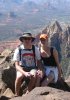
I didn't read anywhere that you go to the Lookout by going up, up, and up before you get to the over and then up again. I saw 7 people on this trail as I crossed over including 2 of the guys that had passed me toward the beginning of Tom's Thumb Trail. We all commented about the haze being pretty thick :( . Nonetheless, I took some photos and a 360 movie. I walked around the Lookout Point area before heading back to try and find a scenic viewpoint to enjoy my light lunch.

Well trying to find shade and scenic didn't quite work out as believe it or not, with all those house-size boulders on the way to the East End Trail, none provided the right kind of shade at this time of day. So I ended up eating underneath the two boulder bridge (I have a photo in my photo set). It was a bit breezy under there but I was in shade. Ambika told me on my longer hikes where it might get hot it is best to sit in shade.

Surprisingly, my hip joints were killing me :( . I don't know if it was the new boots as the hiking wasn't anything out of the ordinary, even with the climbing up the switchbacks. I am trying to take bigger strides but it's hard to say. I enjoyed my snack and got back on the trail again despite the strong desire to take a nap ;) . I took a couple ibuprofen for my hip flexors, tightened and strapped up my boots to the next level in preparation of the descent.

The East End trail is indeed as steep as they say but WOW, what a scenic one :DANCE: . Needless to say I wasn't disappointed that I had to take my time as there was so much to see between the flora and the lizards and the buzzards and the boulders :y: . I encountered 3 hikers on their way up. I can't imagine having to come up and up and up this steep trail. With my new boots, I was sticking pretty good!

1.4 miles later or so I was at the intersection with the Windgate Trail. I drank some more of my Propel and had a couple donut holes for some energy to go this next .9 miles to the Pass. This is where I started struggling in October when it took me awhile to get up this measly hill as the temperature was rising quickly. This time, in spite of hiking 3 miles further, with the cool temps and slight breeze, it was not difficult at all altho I saw a nice rock to sit on for a couple minutes.

1/2 hour later I was sitting at the Pass eating the last of my snack. The name of this trail was living up to its mantra "Wind" gate. But I didn't mind as other than my hip joints, all was going according to plan though a little behind schedule. I got distracted coming down East End :) . I took a couple more ibuprofen and started with the next 4 miles. I wanted to pull out the chrome dome but because of the wind, I ended up waiting until the junction with the Gateway Saddle Trail.

And yes, the chrome dome really gets the looks but I love using it cuz I don't have to wear a hat and it expands my shade area. One fellow says he thot he was seeing a spaceship :sl: . I was glad there was a stiff breeze for much of this hike. I didn't quite make the time I wanted. I have to do some soul searching to decide if a time goal is as important as taking my time in my own way to enjoy these hikes :-k . Today, I was concerned about the heat though so keeping up the pace : rambo : to beat the afternoon heat seemed like a good idea.

A little less than 1 3/4 hr later from Windgate Pass, I arrived at the Gateway Center looking forward to my piece of pizza and coke at Basha's. But I have to say how nice the restrooms are here. Wow.
I couldn't even finish my pizza, not sure why. Anyway, the day before when I walked out of the office I saw that our resident owl had a baby so I wanted to stop by there on my way home to see if I could get a picture. Unfortunately the baby wasn't up so I just got a little movie and a picture of momma. I'll take the camera to work on Tues to see if the baby is up and about.

Here is a video from the hike and a bonus footage of the owl: http://www.youtube.com/watch?v=Ov9d70x9azI
 Geology
 Geology [ checklist ]
[ checklist ]  Quartz
 Named place
 Named place [ checklist ]
[ checklist ]  Mountain Spring
wildflower observationwildflower observationwildflower observationwildflower observationwildflower observation
Wildflowers Observation Isolated

water 1 out of 5water 2 out of 5water 3 out of 5water less than max Mountain Spring Gallon per minute Gallon per minute
_____________________
For me, sometimes it's just as much about the journey as the destination.
Oh, and once in awhile, don't forget to look back at the trail you've traveled.
 
average hiking speed 2.34 mph

WARNING! Hiking and outdoor related sports can be dangerous. Be responsible and prepare for the trip. Study the area you are entering and plan accordingly. Dress for the current and unexpected weather changes. Take plenty of water. Never go alone. Make an itinerary with your plan(s), route(s), destination(s) and expected return time. Give your itinerary to trusted family and/or friends.

helpcommentissue

end of page marker