username
X
password
register
for free!
help
ArticlesGuidesRoutes
 
Photosets
 
 Comments
triplogs   photosets   labels comments more
Superstition Peak 5057 Loop via Hiero - 21 members in 66 triplogs have rated this an average 4.1 ( 1 to 5 best )
1, 2, 3, 4  Next
66 triplogs
login for filter options
Jan 31 2025
avatar

 Guides 41
 Routes 1,626
 Photos 14,983
 Triplogs 2,760

69 male
 Joined Jan 20 2009
 Far NE Phoenix,
Superstition Peak 5057 - Balanced Rock LoopPhoenix, AZ
Phoenix, AZ
Hiking avatar Jan 31 2025
The_EagleTriplogs 2,760
Hiking7.22 Miles 3,042 AEG
Hiking7.22 Miles   5 Hrs   50 Mns   1.44 mph
3,042 ft AEG      50 Mns Break5 LBS Pack
 
1st trip
Partners partners
johnlp
LindaAnn
trekkin_gecko
Route Scout Route Recorded  on Route Scout | Pop | Map | Popup | MapDEX
I threw out three choices to Linda, and she countered by choosing none of them. However, her counter worked out, as I hadn’t been there in a couple of years. Needing witnesses to document the abuse I endure for a future court date, I invited Speedgoats, Kelly, and John.

As Google advertised when we pulled into the lot, there was no parking structure, but there were gender-neutral bathrooms (porta-johns). We made our way to a mostly empty parking lot with a temperature of 39 degrees.

The approach to the Petroglyphs is my least favorite part of this hike, but does afford good views of our target. It's the part that 98% of people come for, but it’s rocky and boring. We passed a few people coming out as we were starting.

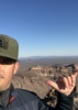
We enjoyed the empty Petroglyph area for a few moments until a clueless trio approached, not having a clue which mountain they were going to climb. That was the last time we saw them. After stopping John from creating his own drawings, we started our climb to the Balanced Rock area. The use trail was mostly easy to follow until we reached the rock. There was a finger trail that led us astray for a bit, until we consulted Route Scout. We lingered around the rock for a while and then began our ascent again. The last obstacle was a 15-foot climbing maneuver up a chute, then it was clear sailing to the magical, powder-free Fliver Disk.

After a short break, John got antsy, and we started our descent. We passed one solo hiker on his way up, then a mass of female hikers coming up from Carney.

On the ridgeline, we saw our first indications of the burn scar. For the most part, it stayed north of the trail.

Now on the Hieroglyphics Trail, it was an easy downhill follow. Approaching the Hieroglyphics area, we began to see the masses milling about—some asking if we made it to the top, some posing for the 'gram, and some wandering aimlessly.

We finished with a mostly full parking lot. Great temps throughout the day and bearable company.

Fauna seen:

0 snakes
0 deer
0 rabbits
0 javelinas
0 chipmunks
0 bears
0 honey badgers
numerous cougar
_____________________
There is a very fine line between "hobby" and "mental illness."
Dave Barry 🦅
 
Jan 16 2025
avatar

 Guides 93
 Routes 397
 Photos 4,984
 Triplogs 4,124

49 male
 Joined Jun 20 2003
 Tucson, AZ
Superstition Peak 5057 Loop via HieroPhoenix, AZ
Phoenix, AZ
Hiking avatar Jan 16 2025
fricknaleyTriplogs 4,124
Hiking13.25 Miles 3,893 AEG
Hiking13.25 Miles   6 Hrs   16 Mns   2.52 mph
3,893 ft AEG   1 Hour    Break10 LBS Pack
 
13 years since I last hiked this loop. Kind of forgot how fantastic it is. Hieroglyphic canyon is just beautiful and relentlessly steep to go up. Glorious hike up the canyon. Pretty cool to be on the ridgeline again too. there is some burn damage up there. chilled on 5057 for a good while. great weather, great day, great hike
_____________________
hi
 
May 15 2024
avatar

 Guides 59
 Routes 1,100
 Photos 1,191
 Triplogs 1,290

male
 Joined Jan 01 2023
 Arizona
Superstition Peak 5057 Loop via HieroPhoenix, AZ
Phoenix, AZ
Hiking avatar May 15 2024
pseudalpineTriplogs 1,290
Hiking12.28 Miles 3,699 AEG
Hiking12.28 Miles   5 Hrs   7 Mns   2.59 mph
3,699 ft AEG      22 Mns Break
 
Route Scout Route Recorded  on Route Scout | Pop | Map | Popup | MapDEX
I've recorded this loop five times and have probably completed it more than ten. I suppose it was time to publish a guide for it then. :-s Hieroglyphic Spring was still slightly trickling, but funky like usual. I'd guess the families and kids that only make it this far still think it's everything is awesome. It was enjoyable ascending the canyon for once without an obscene number of cairns along the way. Perhaps people are catching on that a duck every five feet really isn't necessary (reference the Wave Cave arrows erased for more context). It also was nice to experience the Supes in mid-May with all the wildflowers and fresh leaf outs. The heat usually keeps me away, but today had substantial wildflowers. The flaming yellow and red Dudleya stalks were peaking. I reached the summit in two hours and speaking of culmination, there was an entomology orgy of flying ants, bee flies and tarantula hawks circling. The former two groups were dive bombing and getting spunky with each other, where the ants were antisocial and not crossing over to the other species. :-k I was at the West Boulder Saddle before eight, about three hours into the hike, where there was still some good shade at the pass. After this brief and final break, the stretch dash got hot. Along Goldmine was the only place I saw another person, which was south of Turks Head. She had just turned around, informing me that half her water supply was gone, and she wouldn't be finding the bygone gold mine. Definitely a better, more diverse, scenic and challenging loop than the intensive forest bath of the [ Derrick - Horton Loop ]
 Fauna
 Fauna [ checklist ]
[ checklist ]  Bee Fly
wildflower observationwildflower observationwildflower observationwildflower observationwildflower observation
Wildflowers Observation Substantial
  15 archives
Dec 28 2023
avatar

 Guides 25
 Routes 376
 Photos 5,897
 Triplogs 346

40 male
 Joined Mar 01 2018
 Chandler, AZ
Hieroglyphic - 5057 - 3 Sisters - Shaka Loop, AZ 
Hieroglyphic - 5057 - 3 Sisters - Shaka Loop, AZ
 
Hiking avatar Dec 28 2023
John10sTriplogs 346
Hiking15.25 Miles 3,889 AEG
Hiking15.25 Miles   10 Hrs   41 Mns   1.73 mph
3,889 ft AEG   1 Hour   53 Mns Break
 
1st trip
Route Scout Route Recorded  on Route Scout | Pop | Map | Popup | MapDEX
Schedules finally aligned to get a hike in with ishamod before the end of the year. I usually try to avoid repeats, but I hadn't been to 5057 in almost four years, so when he voted for this one, I was in. We started just before sunrise from Hieroglyphic Trailhead with a few vehicles arriving just as we pulled up. Two hikers were already heading back as we approached the petroglyphs, so we had that area to ourselves, and there were some small pools but no flowing water.

I'd forgotten how well-defined the route is up Hieroglyphic Canyon--there was practically a trail much of the way and a nice path cut through some of the brushier spots. There was a little water in the bottom of the canyon and a few trickles in places, and the spires and scenery were great on the way up. We were finally in sunshine once we got up on the ridgeline and worked our way over to 5057.

The summit register that was there a few years ago is gone, but I did notice one of the reference marks I hadn't spotted last time, kind of oddly placed on top of a rounded boulder. We got there just in time to have the peak to ourselves for a while and eat at the top, then a group of three was heading up from the Balanced Rock route, and another solo hiker beat them to the top as we were about to start down. As we got back on the ridgeline route, we saw another solo hiker heading up toward 5057. [ youtube video ]

We detoured over to Three Sisters on the way down and enjoyed the views. There must've been 20+ vehicles at the Wave Cave lot, even on a weekday. On the way back to the ridgeline we passed a group of four approaching Three Sisters, then saw two more hikers down near the Boulder Creek origin, where there were some larger pools.

After hiking down Carney Spring and detoured over to Shaka Cave before finishing off the loop. We'd seen quite a few hikers all day--probably 10+ groups or individuals along the loop--but it was relatively quiet around the Wave Cave, and we managed to complete that final stretch without anyone asking us for directions to the cave. That might be the first time I've set foot anywhere near that trail and not been asked at least once...I think we should win a prize. Over the last mile or two, five or six powered paragliders were flying around.

We kept a pretty leisurely pace all day and took a lot of breaks at various spots along the way, so we finished just before sunset, but it was nice getting back up to 5057 after a few years and great catching up with ishmod again and getting one more hike in before the end of the year.

water 1 out of 5water less than maxwater less than maxwater less than max Boulder Creek Origin - Ridgeline Route Pools to trickle Pools to trickle
Small pools in the creek bed
 
Sep 13 2023
avatar

 Guides 59
 Routes 1,100
 Photos 1,191
 Triplogs 1,290

male
 Joined Jan 01 2023
 Arizona
Superstition Peak 5057 Loop via HieroPhoenix, AZ
Phoenix, AZ
Hiking avatar Sep 13 2023
pseudalpineTriplogs 1,290
Hiking12.23 Miles 3,628 AEG
Hiking12.23 Miles   6 Hrs   12 Mns   2.29 mph
3,628 ft AEG      51 Mns Break
 
Route Scout Route Recorded  on Route Scout | Pop | Map | Popup | MapDEX
This morning's plan was to hike something easier in the Supes than this loop. I hadn't hiked for about a week, recovering from a debilitating :sk: Strep throat infection and also had to work some. :( On the early drive east, one of the US60 road signs was displaying AZ88 closed - rocks on the road. :doh: (perhaps it displays that always). I suppose we're not doing any hikes from the Canyon Lake area. As sunrise broke, one could see that the NW Supes were getting some action, lots of lightning and rain. I settled on the Hieroglyphic TH because I had my car. We chose CCW because the lightning was very active up on the ridgeline. Usually I'd complete this great hike at a brisker pace, but Dese and I had to shelter three times total, as each wave of rain rolled through with the accompanying and uncomfortably close lightning strikes. The final wave soaked us to the bone, but the sun emerged quickly afterwards. We dried out nearing the 5057 summit. It would of been nice to relax longer there, but swarming termite orgies just aren't my thing. On the descent, a large Coatimundi band crossed in front of us. There were at least three, small young ones (so cute) in the group and they all bristled orange. I've never been able to get a good pic of Coatimundi. Another large adult and one baby crossed behind us after we passed. They look like little monkeys easily scrambling the Supes' rocky terrain. This was a tough hike for Dese, but she powered through. She'll get a good rest this weekend because she isn't allowed to hike in the Grand.
 Meteorology
 Meteorology [ checklist ]
[ checklist ]  Fog
  4 archives
Feb 05 2023
avatar

 Guides 1
 Routes 15
 Photos 520
 Triplogs 38

46 male
 Joined Oct 01 2005
 Queen Creek, AZ
Superstition Peak 5057 Loop via HieroPhoenix, AZ
Phoenix, AZ
Hiking avatar Feb 05 2023
adv_trevTriplogs 38
Hiking13.90 Miles 3,800 AEG
Hiking13.90 Miles   7 Hrs   59 Mns   2.03 mph
3,800 ft AEG   1 Hour   9 Mns Break12 LBS Pack
 no routes
1st trip
It was a great day to hit Superstition. I started at Carney (wave cave) trail and went counter clockwise. I did a side excursion and to the three sisters and the 5057 summit. It was nice seeing a fair amount of people up there tackling the harder stuff. There was a fair amount of water. I wish I had brought my water filter, because I did run out. It was toward the end, so not a big deal.
wildflower observationwildflower observationwildflower observationwildflower observationwildflower observation
Wildflowers Observation Isolated

water 1 out of 5water less than maxwater less than maxwater less than max Boulder Creek Origin - Ridgeline Route Pools to trickle Pools to trickle

water 1 out of 5water 2 out of 5water less than maxwater less than max Hieroglyphic Spring Quart per minute Quart per minute
_____________________
  1 archive
Nov 05 2021
avatar

 Guides 59
 Routes 1,100
 Photos 1,191
 Triplogs 1,290

male
 Joined Jan 01 2023
 Arizona
Superstition Peak 5057 Loop via HieroPhoenix, AZ
Phoenix, AZ
Hiking avatar Nov 05 2021
pseudalpineTriplogs 1,290
Hiking12.27 Miles 3,867 AEG
Hiking12.27 Miles   4 Hrs   56 Mns   2.66 mph
3,867 ft AEG      19 Mns Break
 
Third time was counterclockwise on this wild loop!
  4 archives
Mar 28 2021
avatar

 Guides 59
 Routes 1,100
 Photos 1,191
 Triplogs 1,290

male
 Joined Jan 01 2023
 Arizona
Superstition Peak 5057 Loop via HieroPhoenix, AZ
Phoenix, AZ
Hiking avatar Mar 28 2021
pseudalpineTriplogs 1,290
Hiking12.30 Miles 3,860 AEG
Hiking12.30 Miles
3,860 ft AEG
 
  1 archive
Mar 24 2021
avatar

 Guides 59
 Routes 1,100
 Photos 1,191
 Triplogs 1,290

male
 Joined Jan 01 2023
 Arizona
Superstition Peak 5057 Loop via HieroPhoenix, AZ
Phoenix, AZ
Hiking avatar Mar 24 2021
pseudalpineTriplogs 1,290
Hiking12.30 Miles 3,858 AEG
Hiking12.30 Miles
3,858 ft AEG
 
  2 archives
Dec 20 2020
avatar

 Guides 1
 Routes 447
 Photos 4,407
 Triplogs 938

68 male
 Joined Mar 09 2012
 Gilbert, AZ
Superstition Peak 5057 Loop via HieroPhoenix, AZ
Phoenix, AZ
Hiking avatar Dec 20 2020
rayhustonTriplogs 938
Hiking11.98 Miles 3,830 AEG
Hiking11.98 Miles   9 Hrs   44 Mns   1.62 mph
3,830 ft AEG   2 Hrs   20 Mns Break
 no routes
1st trip
Partners none no partners
Very nice loop. I’ve done all segments before, but was missing the Lost Goldmine trail portion.

I acquired some hiking partners, Chuck, Elisa and Courtney, at the saddle above Hieroglyphic Canyon. They had peak 5057 in their sights but were unsure of the route and asked if they could tag along. I took them the rest of the way.

At the summit, I mentioned the big loop I was doing and told them they were welcome to join me. They agreed. They made coffee and Mountainhouse beef stew for lunch, so the break up top was quite long.

Afterwards we continued along the ridge line to west boulder saddle where we took another long break. The trail in between is as good as I’ve seen it. Of course the fire destroyed all the brushy, prickly stuff you used to avoid.

Everyone was chatty and having a great time until the descent from WB saddle. Though not that long, it’s steep and difficult. I prefer this over the scree nightmare near the top of Hiero, but not everyone would agree.

Once down on Lost Goldmine, the previous happy and chatty group was tired and ready for this hike to be over. It was very quiet the last couple of hours. In hindsight I should have taken them back the way we came. I very much enjoyed this hike, but I felt bad for them.

That said, they all were happy to have accomplished this big hike and even asked if we could hike again sometime. I said sure and exchanged phone numbers with Elisa (mom). I’ll try to find something a little easier.

At the end of a very long day, I stopped at the Walgreens at Hwy 60 and picked up some chocolate milk and Pringles, my favorite post big hike pick me up.
 Culture
 Culture [ checklist ]
[ checklist ]  Ray Bain de Soleil
_____________________
 
Nov 30 2019
avatar

 Guides 41
 Routes 1,626
 Photos 14,983
 Triplogs 2,760

69 male
 Joined Jan 20 2009
 Far NE Phoenix,
Hiero - Balanced Rock - 5057 - 3 Sisters Loop, AZ 
Hiero - Balanced Rock - 5057 - 3 Sisters Loop, AZ
 
Hiking avatar Nov 30 2019
The_EagleTriplogs 2,760
Hiking14.56 Miles 3,856 AEG
Hiking14.56 Miles   9 Hrs   46 Mns   1.66 mph
3,856 ft AEG      59 Mns Break14 LBS Pack
 
1st trip
Route Scout Route Recorded  on Route Scout | Pop | Map | Popup | MapDEX
First car in the Hieroglyphics lot, just before daylight.

The water was flowing good at the Glymphs site.

We ultimately took the well cairned/used route, up past the Balanced Rock. This is a steady climb to the top. We saw a good sized ram just before the toughest part of the climb. I'd definitely take this route to 5057 again. Good views and a tad challenging.

We saw our first hikers on top of 5057. Views to the North and east to the Mazzies and Supes, showed off the previous days snowfall.

Next stop was to visit the sisters for lunch. From our lunch spot you could hear the voices of the visitors to the wave cave below.

Down the West Bolder Saddle Trail, my least favorite trail in the Supes, was slippery from the previous days rain/snow.

Some would find the Lost Goldmine Trail a bit boring, but it's a great trail to take in the views, without having to constantly look at your feet.

Great temps and water everywhere on this loop.
 Named place
 Named place [ checklist ]
[ checklist ]  Pivot Rock - Hiero

water 1 out of 5water 2 out of 5water 3 out of 5water less than max Boulder Creek Origin - Ridgeline Route Medium flow Medium flow
water report recorded in the field on our app Route Scout Looking good
_____________________
There is a very fine line between "hobby" and "mental illness."
Dave Barry 🦅
 
Apr 13 2019
avatar

 Routes 93
 Photos 7,758
 Triplogs 1,691

64 male
 Joined Mar 11 2003
 AZ
Superstition Peak 5057 Loop via HieroPhoenix, AZ
Phoenix, AZ
Hiking avatar Apr 13 2019
wallyfrackTriplogs 1,691
Hiking11.80 Miles 3,858 AEG
Hiking11.80 Miles   5 Hrs   55 Mns   1.99 mph
3,858 ft AEG
 
1st trip
Partners none no partners
With the break in the weather still keeping the temperature moderate I decided to to get out in the western Supes one more time. To keep up the crowd avoidance policy I choose Peak 5057 and it worked out well. I started up Hieroglyphics Trail about 6:30 am and only saw 3 hikers all before the balancing rock turn. The Hieroglyphic Canyon was quiet and I could hear the wings of the raven gathering vegetation for some building. The last time I hiked up here was a rainy new years hike. I think JJ & LP nearly froze. Good Times! :lol: The sun didn't hit me until the ridgeline and then only for part of the way. I was on Peak 5057 by 9 am and it hadn't warmed up yet. At that point I decided the loop would give me a better chance of seeing a gila monster so that was the exit plan. Coming down past Carney Spring about a few hundred yards before the Wave Cave turn off I saw a small gila monster on the trail. The hike back wasn't too bad. It was warm in the sun but the breeze was cool so a really nice day on trail.
 Fauna
 Fauna [ checklist ]
[ checklist ]  Gila Monster
_____________________
  3 archives
Jan 03 2019
avatar

 Routes 61
 Photos 1,008
 Triplogs 224

44 male
 Joined Aug 19 2009
 The Basin
Hieroglyphics Trail #101Phoenix, AZ
Phoenix, AZ
Hiking avatar Jan 03 2019
survivordudeTriplogs 224
Hiking6.47 Miles 2,432 AEG
Hiking6.47 Miles   4 Hrs   24 Mns   1.63 mph
2,432 ft AEG      26 Mns Break
 
1st trip
Partners none no partners
Ive been slacking on adding the trips but better late than never.. After the cold and weather the past week I wanted to see if I could find some snow close by. As I was driving east I saw the top of 5057 covered in snow and decided to take a new route for me up Hieroglyphic Canyon. Temps were in the low 30s at 8AM and all layers were needed on the beginning of the hike. The trail climbed very gently over the hills towards the mountain. As I got to the glyph section, there were a few people already there so I figured I would check them out in more detail on the way back out, thinking maybe there would not be anyone there. :sl: This is where the trail kicks into high gear and really starts to impress. The canyon is wide on the sides but still narrow enough to feel closed inside. The landscape was fantastic. There was water flowing the entire time. The trail is always easy to follow either the path or numerous cairns lead the way. There are a few areas where there is a bit of scrambling needed but nothing too serious. As I gained elevation, I started coming across more and more snow. Some areas where the footing was not so good was made more tricky by all the small seeps that had turned into mini slip n slides. As I finally got to the top of the ridgeline I felt great satisfaction. The plan was to go up to 5057 but as I went on the northeast side of the first peak towards 5057, the snow and ice was just too slippery for me without the proper foot gear, so I had to turn around and almost ski on one foot back down to the saddle. It was super cool to see the Supes covered in snow and experience the canyon the whole time pretty much by myself. Only when I got back to the glyph area, did I realize how popular this place is. I could not believe the amount of people on that trail below the glyphs, on a weekday even! It is still fresh but I think this is my new favorite way up to the top now.
 Named place
 Named place [ checklist ]
[ checklist ]  Weavers Needle
_____________________
“There is nothing that exists outside the thought of the immediate moment.”
  3 archives
Dec 27 2018
avatar

 Guides 7
 Routes 187
 Photos 2,318
 Triplogs 909

74 male
 Joined Dec 10 2016
 Gold Canyon
Superstition Peak 5057 Loop via HieroPhoenix, AZ
Phoenix, AZ
Hiking avatar Dec 27 2018
DaytripperTriplogs 909
Hiking12.87 Miles 3,800 AEG
Hiking12.87 Miles   7 Hrs   45 Mns   1.82 mph
3,800 ft AEG      40 Mns Break15 LBS Pack
 no routes
1st trip
Linked   none no linked trail guides
Partners none no partners
Give yourself plenty of time to do this one, admittedly glad to see the parking lot when I returned. Nice hiking here in cooler weather , I don’t think the temperature made it above 50F today and the stiff breeze on the ridgeline didn’t invite lingering there but did provide entertaining passing clouds, took my longest break at West Boulder saddle out of the wind.The pools of water at the petroglyphs had a slight trickle and even some water noted in the upper canyon pools, traction was a little slippery with the recent rain. Met 3 hikers doing the ridgeline just below the steep scree section , on the way down to west boulder passed one guy , two groups of 3 young ladies and further down two couples with a youngster hope they all made the summit ok. Having just hiked the Lost Goldmine a week ago sort of zoned out along here but did notice a sagauro when rounding Turks Head ,probably older than Arizona, laying across the trail maybe from the Christmas night storm and a couple of cairns constructed to mark the entrance to Chuparosa. Only saw 2 mountain bikers today. I think I’ll take it easy tomorrow.
_____________________
Navy31 Army13
 
May 28 2018
avatar

 Guides 38
 Routes 182
 Photos 1,602
 Triplogs 232

40 male
 Joined Dec 09 2014
 Gilbert, AZ
Superstition Peak 5057 Loop via HieroPhoenix, AZ
Phoenix, AZ
Hiking avatar May 28 2018
jacobemerickTriplogs 232
Hiking13.34 Miles 4,188 AEG
Hiking13.34 Miles   7 Hrs   9 Mns   2.10 mph
4,188 ft AEG      47 Mns Break
 
no photosets
1st trip
Linked   linked  
Partners none no partners
This weekend had more epic plans involving Midnight Mesa, but that all fell through on Sunday when we were 10 miles from Sheep Bridge and I realized that I forgot my boots. Can't do much in the Mazzies with only flip flops. ](*,) So I decided to do this loop, mostly to burn the legs out

Hieroglyphics Trail
Started with the sunrise with a few groups of hikers, lots of families out early in the morning. Saw one small pool at the bottom of the drops, only a few inches in it. Won't be long before the whole canyon is dry. Stayed in the wash to check the 'marked' location of Hieroglyphics Spring, nothing special to see there. Jumped back on trail above. I swear this route gets more defined every time I'm on it, easier to track than the ridgeline trail above. The pools near the saddle were dry (I pulled water from them in Jan 2017) and there is a re-route above them that avoids some of the sheer rock slab. Much easier on the ankles now.

Ridgeline Trail
Not much has changed here. Awesome views and slight breeze. Remembered to avoid the spur trail at the saddle and steered clear of the nasty scree. Easy haul up to 5057 summit, new log for 2018. Rolled down the hill to Three Sisters and hit two of them. Got some good views down to the little one, have some ideas on how to get on it, didn't want to do it today. Continued down to saddle and considered pushing on to Roost and Cave Trail. However, it was hot and I'm lazy and the less time I can spend on Lost Goldmine the better.

Carney and Lost Goldmine
The descent down to Carney just gets less and less fun. Felt like there was a lot more washouts, steep drops, and loose gravel to dealt with than before. Next time I might try to drop near Wave Cave just to make this trail more appealing. Anyways, trailhead here was semi-full, summer temps starting to thin the crowds. And then it was time for the long return on the [s]Hot Oven[/s] Lost Goldmine Trail. It's in good shape, noticed a lot of spur trails heading south, mostly unmarked, and the main trail was consistently flagged w/ those plastic signs. Only saw two groups of hikers on here. Quiet day out here.
_____________________
 
Jan 09 2017
avatar

 Routes 1
 Triplogs 2

74 male
 Joined Dec 28 2013
 Gold Canyon, AZ
Superstition Peak 5057 Loop via HieroPhoenix, AZ
Phoenix, AZ
 Hiking avatar Jan 09 2017
lostgoldmanTriplogs 2
 Hiking7.50 Miles 2,948 AEG
 Hiking7.50 Miles   7 Hrs      1.35 mph
2,948 ft AEG   1 Hour   26 Mns Break25 LBS Pack
 
no photosets
1st trip
Linked   none no linked trail guides
Partners none no partners
Four of us hiked from Cloudview trail head for the Hieroglyphic Spring Trail. We followed the well defined trail past the spring and up the wash. If you go right of the small cave just past the spring you will find a trail leading onward. This trail will eventually take you up to the Ridge Line left of Superstition Mountain Peak. This trail does not have high use so sometimes you really have to look around to see Cairns or other evidence of the trail. The trail continues up along the right side of the wash until you reach the last part of the ascent.

Until you get to the Ridge Line this hike is a continual climb uphill. There are very few places where the trail is close to flat for very long. Because the trail is lightly used, thee are times when the foliage gets in the way. I got more Cholla spines this trip than I have ever gotten before. Since the hike is along side the wash all the way up, all the interesting views are forward or backward until you get to the Ridge Line. However, the views back down the wash and out over the Gold Canyon area are beautiful.

I have been to the Ridge Line several times now. Nonetheless, the views when you get there are awesome. I love the fact that you can look north into the teeth of the Superstition Wilderness or south over Gold Canyon and on into greater Phoenix.

Once you get to the Ridge Line the hike becomes flatter except for a few ascents along the way. There is one place where you climb straight up for about 30 feet. Once you get to the base of the peak you have another hundred feet or so of ascent with the last 50 climbing almost straight up to the peak. If the views from the Ridge Line are awesome, the views from the peak are even better. 360 degrees of the Superstitions. Make sure to sign the log book in the blue ammo box and take plenty of pictures. Since cell reception is great at the top you can take a moment for a social media check in there.
_____________________
 
Feb 06 2015
avatar

 Photos 3,883
 Triplogs 169

80 male
 Joined Mar 18 2012
 mesa,az
Superstition Peak 5057 Loop via HieroPhoenix, AZ
Phoenix, AZ
Hiking avatar Feb 06 2015
jameslcox44Triplogs 169
Hiking9.00 Miles 3,800 AEG
Hiking9.00 Miles   10 Hrs      0.90 mph
3,800 ft AEG
 no routes
1st trip
Linked   linked  
Partners none no partners
A group of Forest Service Volunteers and friends joined to do this hike. Ages 60 to 81, the 8 person group wanted to begin on the hieroglyphic trail, move up past the balanced rock, then move up to 5057. As we cross the ridge just to the left of balanced rock, we moved up to the next summit. As we continued our climb sometimes finding cairns and much of the time without cairns, we continued our scramble upward. The day got quite warm as we progressed toward 5057, so took quite a few rest breaks. From 5057, we dropped down to the ridge line trail and moved back to the hieroglyphic saddle, where we headed down into the canyon. I did have a GPS and will try to attach the track to the posting.
wildflower observationwildflower observationwildflower observationwildflower observationwildflower observation
Wildflowers Observation None
Not many flowers spotted. We

dry Hieroglyphic Canyon Dry Dry
a fair amount of water from recent rains. It was refreshing to see the water moving down the canyon.
_____________________
 
Jan 31 2015
avatar

 Guides 9
 Routes 128
 Photos 1,379
 Triplogs 87

54 male
 Joined Feb 19 2013
 Prescott, AZ
Superstition Peak 5057 via HieroPhoenix, AZ
Phoenix, AZ
Hiking avatar Jan 31 2015
Peter_MedalTriplogs 87
Hiking6.45 Miles 3,127 AEG
Hiking6.45 Miles
3,127 ft AEG
 
1st trip
Launched from Lost Dutchman TH in the dark and rain, banked off trail to Balancing Rock then on to 5057 then back down Hiero with running water falls. A great day in the Supes.
_____________________

"Before there was a trail..... there was no trail"
  2 archives
Mar 15 2014
avatar

 Routes 27
 Photos 189
 Triplogs 29

52 male
 Joined May 27 2013
 Apache Junction,
Lost Goldmine-Hiero-5057-Carney-Loop, AZ 
Lost Goldmine-Hiero-5057-Carney-Loop, AZ
 
Hiking avatar Mar 15 2014
TeamBillyGoatTriplogs 29
Hiking13.83 Miles 3,800 AEG
Hiking13.83 Miles   7 Hrs   30 Mns   2.13 mph
3,800 ft AEG   1 Hour    Break
 no routes
1st trip
I started this hike from Carney Springs Trailhead and completed in a clockwise direction to get the 'somewhat boring' Lost Goldmine trail out of the way first. Then up Hieroglyphic trail to saddle on ridgeline then took a lunch break at 5057 and enjoyed the view as always. Then returned via west boulder saddle... Nice thorough workout of a loop/lasso hike... I love them-there hills....
 Culture
 Culture [ checklist ]
[ checklist ]  Ghost?  Humor
 Named place
 Named place [ checklist ]
[ checklist ]  Superstition Mountain 5057
_____________________
 
Mar 14 2014
avatar

 Routes 1
 Photos 551
 Triplogs 37

79 male
 Joined May 17 2014
 Apache Junction,
Hiero to Ridge to Carney to Goldmine, AZ 
Hiero to Ridge to Carney to Goldmine, AZ
 
Hiking avatar Mar 14 2014
PeraltaPhilTriplogs 37
Hiking12.00 Miles
Hiking12.00 Miles   9 Hrs      1.33 mph
20 LBS Pack
 no routesno photosets
1st trip
Partners none no partners
I wanted to hike the Hieroglyphic Trail to the Ridge Line. On my first attempt, a few days earlier, I made a right turn mistake. I ended up bushwacking down to the Goldmine Trail through some rough terrain. There was a trail but at one point I had to slide down vertically about 12 feet, with nothing to hang onto but the rock face. I ended up on my back in a bush, nothing broken except a walking stick. I did make it back to the trailhead okay.

On March 14, 2014, at 6:30 AM I began a second attempt. This time as I was in the valley looking up at the ridge line I did follow the trail to the left. Nearing the top I had to scale a slanted rock area littered with loose rock pieces. After making it through this part I followed a trail to the right which led me to the ridge line.

** Let me mention that On Feb. 23, 2014 I had made an ascent to the Superstition Peak from the Carney Springs Trail. It was my first time. I did not look for the register book, but I did hike the trail to the other side. It was near noon so I decided to turn back. I did not want to be out after dark, plus I was getting tired.

Now, back to this hike. After reaching the ridge I followed the trail to Superstition Peak. Having hiked down from this peak 3 weeks prior I had no difficulty hiking down to the Carney Springs Trailhead. Actually, after I got through the wilderness fence I picked up the Goldmine Trail and headed back to the Hieroglyphic trail parking lot, arriving at 3:30 PM.

It was quite exciting for me to have accomplished this hike. The scenery was beautiful, I had no run-ins with critters, I still had water and I was not injured. I was happy that I found the correct trail to the top this time.

In April I hiked the Flat Iron and a short way on the ridge line. Somehow I need to hike the ridge line between the Superstition Peak and the Flat Iron. I am experimenting with the Hog Canyon Wash up to the ridge line. Then I could head west and down Siphon Draw to complete 2 half ridge line hikes. I hiked four times through Hog Canyon to just short of where the falls should be. I have to begin early enough because hiking the "Hog" is slow going, at least for me. I wish I could show pictures but my camera batteries were dead and I had no spares.

Oh well, now I have an excuse to take this hike again.
_____________________
 
average hiking speed 1.87 mph
1, 2, 3, 4  Next

WARNING! Hiking and outdoor related sports can be dangerous. Be responsible and prepare for the trip. Study the area you are entering and plan accordingly. Dress for the current and unexpected weather changes. Take plenty of water. Never go alone. Make an itinerary with your plan(s), route(s), destination(s) and expected return time. Give your itinerary to trusted family and/or friends.

helpcommentissue

end of page marker