username
X
password
register
for free!
help
ArticlesGuidesRoutes
 
Photosets
 
 Comments
triplogs   photosets   labels comments more
Damifino Trail - 8 members in 25 triplogs have rated this an average 4.4 ( 1 to 5 best )
1, 2  Next
25 triplogs
login for filter options
Nov 17 2024
avatar

 Guides 12
 Routes 192
 Photos 863
 Triplogs 356

42 male
 Joined Nov 30 2015
 Phoenix, AZ
Hangover TrailSedona, AZ
Sedona, AZ
Hiking avatar Nov 17 2024
ShatteredArmTriplogs 356
Hiking8.40 Miles 2,100 AEG
Hiking8.40 Miles   3 Hrs   44 Mns   2.25 mph
2,100 ft AEG
 
no photosets
1st trip
Linked   linked  
Partners none no partners
Little trip to Sedona, mostly as a get together. Casner Canyon trail was suggested, and I mentioned the trail connecting it to Hangover, so we decided to give that a go. Almost managed to stay dry at the Oak Creek crossing, but ultimately didn't trust the grip on the rocks to do the the longest hop.

The Damfino junction was pretty obvious. Not marked, but any attempts by the FS to hide this trail have clearly been futile. Trail was easy to follow for a half mile or so, then it faded a bit. At one point we stayed along the rim above Oak Creek too long and had to go cross country back up the ridge. On the slickrock, we followed a shelf for awhile, but it eventually pinched off and we went farther up.

Once we got to the Mitten Ridge saddle, we decided we may as well do the loop. Hangover is always fun. When we got to where it jogged south before Cow Pies, we decided to go down a side drainage of Bear Wallow instead of staying with the trail. A couple of minor obstacles, one pour-off that required a bypass, some minor brush and deadfall, but overall it was fun. Got back to the trail right near the other Hangover junction.

Following the Damifino trail was a bit easier on the way back down. Stayed up at the top of the slickrock until we were right above the ridge crest, which I think is the best move.
_____________________
 
Oct 24 2022
avatar

 Guides 170
 Routes 148
 Photos 5,914
 Triplogs 2,097

48 male
 Joined Apr 12 2004
 Tucson, AZ
Damifino TrailSedona, AZ
Sedona, AZ
Hiking avatar Oct 24 2022
PrestonSandsTriplogs 2,097
Hiking5.10 Miles 1,343 AEG
Hiking5.10 Miles
1,343 ft AEG
 
Linked   none no linked trail guides
Partners none no partners
Work and 89A construction delays put an end to my hope of a Damifino-Hangover loop, but I still had time for Damifino itself, one of my top 2 Sedona favorites. I parked along the highway, dropped down to Casner Canyon Trail, waded across Oak Creek, and soon came across 2 other hikers, who were as surprised to see me as I them. Made the turn onto Damifino and cruised up the ridge and then the bedrock terraces, which I enjoy.

The sun was low on the horizon when I hit the saddle on Mitten Ridge, so I went down the south side of the ridge on Hangover for a bit to check out some puddle basins I had seen for photo ops. I got a few sunset and reflection photos, and noted the rugged terrain below me…looks like it would be tricky/sketchy trying to descend off trail to Schnebly Hill Road below.

Once the sun had set behind Mingus Mountain, it started getting dark quick, so I headed back north on Damifino, knowing it would be easier to negotiate the terraces before dark. Waded through chilly Oak Creek one more time in the dark and then drove back to Flagstaff.
_____________________
"…you never know when a hike might break out" -Jim Gaffigan
 
Oct 09 2022
avatar

 Guides 170
 Routes 148
 Photos 5,914
 Triplogs 2,097

48 male
 Joined Apr 12 2004
 Tucson, AZ
Damifino TrailSedona, AZ
Sedona, AZ
Hiking avatar Oct 09 2022
PrestonSandsTriplogs 2,097
Hiking1.35 Miles 355 AEG
Hiking1.35 Miles
355 ft AEG
 
Linked   none no linked trail guides
Partners partners
ryan321
Prescott trip with Ryan, day 3:
Left the truck under ominous skies, dropped into Oak Creek Canyon, forded the creek, and started up my favorite Sedona Trail. Re-evaluating the weather on top of the ridge, we opted to retreat and try a different Sedona hike. Disappointing for sure, but neither of us wanted to chance lightning on Mitten Ridge.
_____________________
"…you never know when a hike might break out" -Jim Gaffigan
  1 archive
May 21 2022
avatar

 Guides 41
 Routes 1,627
 Photos 14,983
 Triplogs 2,762

69 male
 Joined Jan 20 2009
 Far NE Phoenix,
Casner Damifino Hangover Schnebly Hill Loop, AZ 
Casner Damifino Hangover Schnebly Hill Loop, AZ
 
Hiking avatar May 21 2022
The_EagleTriplogs 2,762
Hiking15.06 Miles 3,168 AEG
Hiking15.06 Miles   7 Hrs   59 Mns   2.22 mph
3,168 ft AEG   1 Hour   12 Mns Break14 LBS Pack
 
1st trip
Route Scout Route Recorded  on Route Scout | Pop | Map | Popup | MapDEX
It's been awhile since we've hiken in Sedona. The forecast was showing favorable temps, so I worked up a loop with some of my favorites. I'm also not a fan of fighting the afternoon traffice in Sedona, so we came in via Schnebly Hill Rd, off I-17. This is 6 miles of dirt to get to the Schnebly Hill Vista TH. Any vehicle can make it to this point. After that, HC with good tires are an absolute must. The parking lot is worse than any portion of the road to this point.

We started on Casner Canyon Trail #11 heading down. The views open up to the Sedona city area as you drop. Towards Oak Creek, you start seeing some interesting geology. The Oak Creek area is very picturesque.

On the Damifino Trail, it appears that they may have decommissioned the lower portion ending at Mitten Ridge. Where it meets Casner Canyon, it is no longer obvious. Once you get in a bit it becomes very obvious and is easy to follow all the way to the smooth red rock section. The important part here is to get high enough to hit the trail on the proper contour to get to Mitten Ridge.

The Hangover Trail is my favorite trail in Sedona. It never disappoints. I still thinks MTB'ers who do this trail have multiple screws loose.

On the Munds Wagon Trail we start the long climb, past the Cow Pies TH, past the Merry Go Round and up Schnebly Hill Trail #158. We climbed up to the saddle just before the steep ascent to Munds Mountain. We took a late lunch and then hit the FR's back to the TH.

A great day in Sedona
_____________________
There is a very fine line between "hobby" and "mental illness."
Dave Barry 🦅
 
May 21 2022
avatar

 Guides 264
 Routes 2,798
 Photos 14,514
 Triplogs 5,895

55 male
 Joined Nov 20 1996
 
Casner Damifino Hangover Schnebly Hill Loop, AZ 
Casner Damifino Hangover Schnebly Hill Loop, AZ
 
Hiking avatar May 21 2022
joebartelsTriplogs 5,895
Hiking14.46 Miles 3,011 AEG
Hiking14.46 Miles   7 Hrs   59 Mns   2.17 mph
3,011 ft AEG   1 Hour   19 Mns Break
 
1st trip
Route Scout Route Recorded  on Route Scout | Pop | Map | Popup | MapDEX
From Schnebly Hill Vista we headed out on Casner Canyon Trail #11 at 55°. This is among the most under-hiked trail with stunning views. 1,500 ft elevation drop does not lure out-n-back hikers and looping options are not easy.

Reaching Oak Creek, the majesty of this loop hits another high note. Damifino Trail heads up before the creek. It is blocked off because it is not an official trail. Damfino Canyon (minus the first i) is further south of Mitten Ridge.

Heading up starts rough. Then it is a nice stroll above Grasshopper Point. Two daisy-chained red rock ascents a bit later pushed my limits of balance. Then it's on to the prize Hangover Trail. Despite whining about overcrowding since I started HAZ, we encounter just one guy on the north, a couple rounding the mitten, and a few more down into Bear Wallow Canyon.

We merged into Munds Wagon Trail #78 and took Schnebly Hill Trail #158 up the rim. These two trails will rate low for most. Bruce had his heart set on lunch at the Munds - Jack Canyon saddle. There is not a great lunch spot so we returned a bit to a more seemingly comfortable spot under the pines. Souvenir bug bites surfaced a day later from sitting in the pine needles.

Random bird sample picked up: Bewick's Wren, a Western Wood-pewee, and Geen-tailed Tohwee. Never heard of any but they were all in the fauna label index.

Synopsis
Under 2 miles in, it felt like I was on pace to edge 1,000 photos. If you can fend off Carpal Tibber Syndrome and can negotiate steep scrambling on sandstone this is a dandy loop. Passed under two dozen hikers, more out-n-about in the distance. Two helicopter tours above, and four jeep tours along Schnebly.
 Flora
 Flora [ checklist ]
[ checklist ]  Arizona Cypress
 Named place
 Named place [ checklist ]
[ checklist ]  Munds Mountain
wildflower observationwildflower observationwildflower observationwildflower observationwildflower observation
Wildflowers Observation Isolated

dry Casner Canyon Dry Dry
Casner was dry except for small undesirable puddles.
_____________________
- joe
 
Feb 26 2021
avatar

 Guides 170
 Routes 148
 Photos 5,914
 Triplogs 2,097

48 male
 Joined Apr 12 2004
 Tucson, AZ
Damifino TrailSedona, AZ
Sedona, AZ
Hiking avatar Feb 26 2021
PrestonSandsTriplogs 2,097
Hiking6.00 Miles 1,190 AEG
Hiking6.00 Miles   2 Hrs   34 Mns   2.50 mph
1,190 ft AEG      10 Mns Break
 
Linked   linked  
Partners none no partners
Parked along 89A and dropped off the highway ledge to Oak Creek. Waded through Oak Creek and then continued up to the north end of Damifino. Damifino had cut brush and limbs blocking the start of the trail. I assume the Forest Service might be trying to discourage its use. Not much sign of traffic on the route, but enough footprints that one can tell it still gets used. I moved up the ridge quickly but went too high up on the sandstone ledges, so I scrambled back down and soon found the route again. Climbed over more logs blocking the south end of Damifino at the saddle on Mitten Ridge. I then turned on to Hangover Trail and journeyed west. It had been years since my first hike on Hangover and it was just as amazing as I had remembered. Love those Hangover views and being among the red rock towers. I reluctantly turned around at the west end of the ridge as sunset approached, wishing I had time for a Hangover loop. Enjoyed a great sunset on Damifino and made the Oak Creek crossing at dusk. Booked it back to Flagstaff afterward for pizza from Fratellis with the family.
_____________________
"…you never know when a hike might break out" -Jim Gaffigan
  1 archive
May 25 2019
avatar

 Guides 99
 Routes 1,487
 Photos 16,077
 Triplogs 1,377

male
 Joined Jan 07 2017
 Fountain Hills,
Sedona Hike: Hungover Elephant, AZ 
Sedona Hike: Hungover Elephant, AZ
 
Hiking avatar May 25 2019
DixieFlyerTriplogs 1,377
Hiking11.80 Miles 2,236 AEG
Hiking11.80 Miles   5 Hrs   35 Mns   2.90 mph
2,236 ft AEG   1 Hour   31 Mns Break
 
Tracie and I did this hike earlier in the week, but we were not able to locate the cave near the Mitten Ridge saddle, so we wanted to go back and try again. I took a few friends out there with me this time, so we had a small group.

We had better luck this time and we were able to find the cave and crawl into it. The opening is small, and once you were in you had to crawl in the dusty ground for a short distance. Then the cave opened up into a small room that is 8 feet to 9 feet high, and I'd guess 15 feet X 25 feet. It's not something that you see everyday on a hike!

We also went up to Window Rock again and explored a couple of the small arches that are beyond Elephant Arch. Two people in the group climbed up to the top of Window Rock, but that climb had more exposure than I wanted today so I did not climb up to the top of the rock.
wildflower observationwildflower observationwildflower observationwildflower observationwildflower observation
Wildflowers Observation Isolated
_____________________
Civilization is a nice place to visit but I wouldn't want to live there
 
May 21 2019
avatar

 Guides 99
 Routes 1,487
 Photos 16,077
 Triplogs 1,377

male
 Joined Jan 07 2017
 Fountain Hills,
Sedona Hike: Hungover Elephant, AZ 
Sedona Hike: Hungover Elephant, AZ
 
Hiking avatar May 21 2019
DixieFlyerTriplogs 1,377
Hiking12.10 Miles 2,514 AEG
Hiking12.10 Miles   6 Hrs   11 Mns   2.73 mph
2,514 ft AEG   1 Hour   45 Mns Break
 
It has been a long time since I have hiked on the Hangover Trail, and Tracie had never been, so we decided to head up to the red rock country of Sedona. I also wanted to check out Elephant Arch and the other arches above the Hangover Trail, so we checked that box also.

We started and ended the hike at the Huckaby TH. Schnebly Hill Road was paved all the way to the TH, although the road is not in pristine condition. In fact, the pavement in the TH parking lot was better than the road.

We decided to hike all the way on the Munds Wagon Trail to the Munds Wagon TH. This added about 2.5 miles and 550' of elevation gain to the hike as opposed to just doing the Cow Pies-Hangover Loop. The views were nice on the ascent up to the TH, so it was worth it.

We did the loop CCW, so on the way back down we took the Cow Pies Trail up to the Hangover Trail. In spite of Cow Pies odoriferous name, there is nothing to step on that will ruin your day!

The Hangover Trail was the highlight of the hike. It was fun to hike on and there were some awesome views along the view. It was cool on the west side of Mitten Ridge seeing the cliffs literally hang over the trail.

While on Mitten Ridge, before making our way on the west side of the ridge, I tried unsuccessfully to locate a sinkhole that some others talked about in their triplogs. I reviewing my route, I must have walked right past the sinkhole -- thankfully I did not fall in! From the saddle atop Mitten Ridge, we went for a short distance on the Damifino Trail, and then bushwhacked up to the cliff walls in our futile search for the sinkhole.

I have read that there is an interesting bit of history behind the name of the Damifino Trail. Back in the day, a survey crew was in the area, and one surveyer asked another what the name of the canyon was. The second surveyer's respone was "damn if I know". So now you know how the trail acquired its name!

On the initial part of the hike, I had spotted Elephant Arch and 3 other arches high above us. I believe that some folks refer to this as Window Rock. On the way back on the Hangover Trail, we went off trail and climbed up to Elephant Arch. I would have gone over to the other 3 smaller arches but the wind was blowing like crazy, so we decided to save the other arches for another day.

On the way out I wound up hiking quite a bit on Schebly Hill Rd. instead of staying on the Munds Wagon Trail. I did not make that mistake on the way back, which was fortunate since there were lots of jeeps on the jeep road in the afternoon.

imho, this hike is a keeper!
wildflower observationwildflower observationwildflower observationwildflower observationwildflower observation
Wildflowers Observation Isolated
There was not much in the way of wildflowers. I saw a few lupines and a couple of cool claret cup cactus, but that was about it.
_____________________
Civilization is a nice place to visit but I wouldn't want to live there
  3 archives
May 07 2018
avatar

 Guides 1
 Routes 57
 Photos 1,122
 Triplogs 64

70 male
 Joined May 29 2013
 Oakland Gardens,
Damifino TrailSedona, AZ
Sedona, AZ
Hiking avatar May 07 2018
roaminghikerTriplogs 64
Hiking1.60 Miles 720 AEG
Hiking1.60 Miles
720 ft AEG
 
1st trip
Linked   none no linked trail guides
Partners none no partners

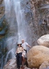
The Damifino Trail, at this writing, continues as an eminently passable and amply scenic passage for the intrepid hiker. The Damifino in Sedona, if you are familiar, branches off the Casner Canyon just after the Casner crosses Oak Creek. The Damifino then runs upward and southeastward through successive sections of low shrubs, open slick rock and finally wooded ledge, to meet the Hangover Trail at a midpoint in that trail.

The Damifino carries an unofficial, and thus unmaintained, status. The trail, evidently developed when the trail system around Sedona grew into somewhat of a mixed menagerie, failed to garner official recognition in the more recent efforts to create a more standard, stable system. So for example, in contrast to Damifino, Hangover Trail operates under official sanction, and Bear Mountain, once poorly marked, now sports sufficiently numerous white painted blazes. But to demonstrate the divide in recognition status, my look shows that no official sanction exists for the trail-of-sorts to the top of Pyramid Mountain southwest of Sedona.

But back to Damifino. The trail remains readily passable, but with a glitch or two. In terms of passability, the trailheads do not hide, with the upper trail head virtually looking one in the face at a switchback in Hangover as that trail passes between two red rock spires, and the lower trail head sits at a reasonably visible long log, laying slated against a tree, a few hundred feet after Casner Canyon crosses Oak Creek. The trail remains distinct, with the familiar compacted soil and rocks, and broken twigs and branches, of traveled trails. And critically, vegetation and underbrush have not in any significant way encroached or hidden trail, and no dead pines or fallen boulders block progress. Past build outs of rocks to create passable ledges appear to still survive. All this despite the trail not receiving ongoing maintenance.

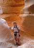
But a few glitches loom. About 0.2 miles into the Damifino at the upper end, a rock fall, or soil slide, has scoured a twenty foot section, leaving a bare, open, slanted slick rock section. Nothing clearly indicates whether a trail ever existed across this bare stretch, but regardless of past history, no trail or even markings point the way. But no worries. At this writing, one can pass this gap by scrambling down a few feet to the bare rock, walking basically straight across, then scrambling back up the other side. Now the trail ends on either side of this opening do not lie exactly straight across from each other. So upon scrambling back up, one will find they one likely did not traverse the open to the trail end on the other side. So one must spy through the low vegetation and then push through this vegetation to regain a spot on the trail.

A second glitch bedevils the hiker, the lack of any trail blazes or cairns. So a GPS track proves helpful, maybe necessary. In the open slick rock section at about 0.4 miles in at the upper end, one might sense one should head down the terraced slick rock quickly, at a good downward angle. Such an approach might work, but the GPS track directs one to stay high and hike around at the same level to the more northern side before descending. Two warning barriers of stone and branches sit on this northern traverse to signal the approximate points to begin switchbacks to descend on the slick rock.
In the low shrub growth below the slick rock, the trail passes alternately through dense shrub and open rock expanse. When in a good number of the open expanses, the entries back to the trail through the shrub do not pop out at one. And the shrub, though only two or three feet high, has grown sufficiently dense to just wing it off-trail. So again a GPS track proves useful, maybe essential.

What GPS tracks? I extracted a track here at Hike Arizona prior to my taking the trail, and that track proved accurate and on point. I uploaded my own track, which matches, closely, the extracted track. Now my route on the slick rock section of Damifino meandered from the HAZ track, but my track does retain what I see as the essential step of rounding high to the more northern side.

As for trail biking, I do not, could not even attempt for fear of injury or permanent disability, attempt that sport, on any trail. But while bikers may in fact now use the Damifino, I don’t see anything but poor effort-reward. The twenty foot rock slide break, while an easy scramble for a hiker, would seemingly require huge and frustrating effort for a biker to stop and hoist a bike up and down to the bare rock, and through the vegetation. Once on the slick rock section, the biker would likely find excellent challenges, but the upper wooded section before that runs just flat and narrow, more pain to traverse by bike than pleasure. And the low shrub area might require stopping, annoyingly, to figure out how to re-enter the trail after each open area. Finally, at the Casner Canyon end, the trail descends via short, sharp switch backs, which again might require dismounts. And then one would need to cross the creek.

However I don’t bike, so these perceptions might prove just misperceptions.

Now back to hiking. I mentioned the scenic wonders. These begin upon exiting the short wooded section when starting at the Hangover end. At that point, we stand on an expansive spread of rounded and terraced slick rock, while above us towers a majestic red rock tower. While maybe not unlike other trails in Sedona, we have arrived in a location few will visit, and though we might have hiked but a moderate distance and height, we can allow ourselves the satisfaction of reaching a spot off the beaten path.

And as we traverse the slick rock, and descend through the shrubs of the lower section, we experience an unobstructed view of the red of Steamboat rock, the grand and towering heights of Wilson Mountain, and beyond that the stately Capital Butte. To our left and right loom rich red formations that we see up and close while others must observe them from the pull offs on Route 179, or across from Thompson trail and the like.

A final note. The Damifino allows an intriguing loop. With the Damifino, we can link the section of Casner Canyon Tail from the Creek up to the Mogollon Rim, to a section of Schnebly Hill Road, then down and around on Munds Wagon, Cows Pies and Hangover, the midpoint of which we pick up Damifino back down to Casner Canyon at the creek.

Enough said, so I will end with a simple note that Damifino remains open and available as a hiking option, a scenic joy, and a linking trail.


_____________________
 
May 07 2018
avatar

 Guides 1
 Routes 57
 Photos 1,122
 Triplogs 64

70 male
 Joined May 29 2013
 Oakland Gardens,
Casner Canyon to Damifino Loop, AZ 
Casner Canyon to Damifino Loop, AZ
 
Hiking avatar May 07 2018
roaminghikerTriplogs 64
Hiking8.40 Miles 1,814 AEG
Hiking8.40 Miles   5 Hrs   50 Mns   1.44 mph
1,814 ft AEG
 
1st trip
Having visited Sedona at various times, I have been enchanted by the red rock formations just north of town east of Midgley Bridge across Route 89A.

As I surveyed trails into those formations, some offered potential, but not enough. Casner Canyon held interest, but ran a bit north of the formations. And then the rather daunting creek crossing at the trail’s start made me wonder if the vantage point of the trail warranted the effort of crossing. Hangover Trail, reached via Munds Wagon, did provide a short look into the formations from the south, but turned back to Munds Wagon before reaching the center of the formations.

I then discovered the unofficial Damifino trail. Being unofficial, the trail would go unmaintained, but the snippets about the trail on various web sites indicated the trail still allowed passage. And the Damifino ran to and through the formations of interest, at least sufficiently close for good views.

With the Damifino discovered, a quick look showed not only does the Damifino cover otherwise untrailed vistas, but Damifino allows a rather glorious loop. This loop starts at the Casner trial head, up Casner, across the Mogollon Plateau until Casner intersects Schnebly Hill Road at an overlook named, guess what, the Schnebly Hill Vista.

From the vista, the loop takes Schnebly Hill Road down and around a large outcropping, then to an upper trailhead on Munds Wagon. We then proceed on Munds around Merry-Go-Rock, to Cows Pies, and Cow Pies to Hangover.

We now reach the key to the loop, which otherwise ceases to exist. Midway on Hangover, the loop catches Damifino Trail. (Note, I have entered a Damifino triplog, which provides insights into navigating that trail). Damifino runs west and north through the red rock formations that enchanted and enchant me, then down to intersect Casner Canyon just at Oak Creek, closing the loop. Another creek crossing brings one back to where one likely parked, or was dropped off.

This loop engulfs the hiker in the breath of the geologies and ecologies of Sedona. The loop features the mixed vegetation along Oak Creek, the mountainside forest as one ascends Casner Canyon trail, then the twisted cubic dark rock formations gracing Casner just before the rim. Above the rim, on the Mogollon Plateau, one enters a completely different zone of open flat grassland dotted with randomly placed pines.

One encounters humanity along the Schnebly Hill Road stretch. These intrusions, certainly gentle but nevertheless noticeable, include a fiber cable maker post, a likely passing by a pink jeep entourage, drainage pipes and retaining barriers, and an occasional road sign.

However, one soon reaches an upper trailhead for Munds Wagon, which we take to Cow Pies and Hangover. One enters along this stretch the spectacular and renowned red rock vistas of Schnebly Hill on one side, and the towering white flanks of Munds Mountain on the other. If hiking, do not be deterred by the warning sign at the junction of Cow Pies and Hangover. The sign cautions bikers; hiking Hangover presents challenges, but nothing like the technical skills bikers must possess.

In any event, on Cow Pies, Hangover, and then to Damifino, one traverses right over and beneath to the red rock in all its forms and glory. Do notice how vegetation breaks through, how the red rock forms both rounded terraces and also vertical cliffs, how precocious pines sit high among the rocks, how cleaved boulders lay strew or have created a trail of broken rock, and how different environments as the sandstone formed hundred of millions of years ago created different colors and bands.

As one completes the Damifino, the formations to the west across Route 89A loom larger and larger, and one stands among the rock formations on all sides. Stop, don’t hurry, and admire the beauty and the vistas. Also catch the result of the fault that split Wilson Mountain, where the east side slide down relative to the west side. The dark rock cap on the east sit a good distances below that on the west, the result of the faulting and subsequent slippage on the east side.

The loop ends with another crossing of Oak Creek. I crossed both in and out without incident, but needing a good bit of care and precision to pick the proper rocks to use, both those above and below the water line. Falling in wouldn’t be the worst, but would leave one wet, a likely annoying and uncomfortable situation, except maybe in the warm days of mid-summer.

The loop provides magnificent views, allows a traverse of the relatively uncharted span of the Damifino, offers a good dose of solitude, and invigorates but not exhausts with a length of 10 miles and a cumulative elevation gain of several thousand feet.
 Geology
 Geology [ checklist ]
[ checklist ]  Basaltic Columns
_____________________
  2 archives
Oct 21 2017
avatar

 Photos 105
 Triplogs 13

51 male
 Joined Feb 26 2009
 Mesa, AZ
Damifino TrailSedona, AZ
Sedona, AZ
Hiking avatar Oct 21 2017
Xiled1Triplogs 13
Hiking11.40 Miles 720 AEG
Hiking11.40 Miles
720 ft AEG
 no routes
1st trip
Partners none no partners
We hiked from the Midgely Bridge and made a loop including the Damifino, Hangover, Munds Wagon, and Huckaby trails. Oak creek flow was passable with only wet feet. We proceeded clockwise and I don't really recommend that. Huckaby and Munds Wagon are relatively boring and open. Best to get those out of the way first. Typical traffic to get back through Sedona, took 30 minutes from the bridge.
foliage observationfoliage observationfoliage observationfoliage observationfoliage observation
Autumn Foliage Observation Isolated
_____________________
 
Jul 02 2017
avatar

 Guides 170
 Routes 148
 Photos 5,914
 Triplogs 2,097

48 male
 Joined Apr 12 2004
 Tucson, AZ
Damifino TrailSedona, AZ
Sedona, AZ
Hiking avatar Jul 02 2017
PrestonSandsTriplogs 2,097
Hiking5.00 Miles 952 AEG
Hiking5.00 Miles
952 ft AEG
 
Linked   none no linked trail guides
Partners none no partners
Caught an Uber ride to Grasshopper Point which was choked with cars waiting to enter. I ducked into the bushes, headed for the creek, and started up canyon on the Casner Canyon Trail. Even my secret swimming hole had been invaded. So many people swarming Sedona on 4th of July weekend! I soaked in the creek for a minute to keep me cool on the exposed ridge above before turning off onto Damifino. Since my last trip, someone painted a number of small yellow dots to periodically mark the trail that will surely get some of the more vocal members on this site riled up. Same old Damifino, otherwise. Made it to the saddle where the Hangover Trail joins, took some photos, and started back down. Cooled off in Oak Creek again, and then caught my ride at the highway.
_____________________
"…you never know when a hike might break out" -Jim Gaffigan
 
Feb 03 2017
avatar

 Guides 13
 Routes 38
 Photos 1,651
 Triplogs 577

60 male
 Joined Nov 15 2005
 Jackson, CA
Hangover TrailSedona, AZ
Sedona, AZ
Hiking avatar Feb 03 2017
toddakTriplogs 577
Hiking20.00 Miles 3,000 AEG
Hiking20.00 Miles   9 Hrs      2.22 mph
3,000 ft AEG
 no routesno photosets
1st trip
Never really noticed all the cool trails in this scenic area, and Hangover Trail is a work of art!

From the Schnebly Hill trailhead: warmup out-and-back on Huckaby, up Munds, up west side of Hangover, north on Damifino, up Casner to the rim, road walk down Schnebly, back down Munds, up Cowpies, full length of Hangover, back on Munds.

All the drainages are running strong with snowmelt off the rim and Oak Creek was raging. Casner is a bit overgrown near the top but not too bad.
_____________________
 
Jun 01 2014
avatar

 Guides 170
 Routes 148
 Photos 5,914
 Triplogs 2,097

48 male
 Joined Apr 12 2004
 Tucson, AZ
Damifino TrailSedona, AZ
Sedona, AZ
Hiking avatar Jun 01 2014
PrestonSandsTriplogs 2,097
Hiking4.50 Miles 1,059 AEG
Hiking4.50 Miles
1,059 ft AEG
 
Linked   linked  
Partners none no partners
After driving up Oak Creek Canyon to check out the Slide Fire damage, I parked along the highway and dropped down onto Allens Bend Trail late in the afternoon. Crossed the creek, turned onto Damifino and followed it up to the saddle on Mitten Ridge where high winds nearly knocked me down. Went for a swim at dusk in Oak Creek on the way back and then drove south to head to Flagstaff for the night.

Flagstaff road trip hike 2 of 4
_____________________
"…you never know when a hike might break out" -Jim Gaffigan
 
Oct 26 2013
avatar

 Guides 170
 Routes 148
 Photos 5,914
 Triplogs 2,097

48 male
 Joined Apr 12 2004
 Tucson, AZ
Damifino TrailSedona, AZ
Sedona, AZ
Hiking avatar Oct 26 2013
PrestonSandsTriplogs 2,097
Hiking10.00 Miles 1,941 AEG
Hiking10.00 Miles   4 Hrs   16 Mns   2.84 mph
1,941 ft AEG      45 Mns Break14 LBS Pack
 
clockwise Mitten Ridge loop: Huckaby/Allens Bend/Casner Canyon/Damifino/Overhang/Munds Wagon

I had been wanting to do a variation of the Mitten Ridge loop I had done a month earlier, and check out the new Overhang Trail as well. Started off at the Schnebly Hill road trailhead, going north on Huckaby, where the sycamores and ash trees were at peak autumn brilliance. Continued on down Allens Bend Trail onto Casner Canyon Trail, where I stopped for a very cold (and brief) swim in Oak Creek. I crossed the creek, then turned south to climb to Mitten Ridge on the Damifino Trail, where I could see a ribbon of fall color winding up Oak Creek Canyon. Once at the saddle on Mitten Ridge, I turned west onto the new Overhang Trail, which was the highlight of the entire loop for me, following a narrow catwalk along the north side below massive cliffs. After many photos, I made the U-turn onto the south slope of Mitten Ridge and descended to Munds Wagon Trail. Made the last leg back on Schnebly Hill Road in the growing darkness, happy to have had the opportunity to do this great loop. I definitely recommend it.
foliage observationfoliage observationfoliage observationfoliage observationfoliage observation
Autumn Foliage Observation Substantial
_____________________
"…you never know when a hike might break out" -Jim Gaffigan
 
Sep 29 2013
avatar

 Guides 170
 Routes 148
 Photos 5,914
 Triplogs 2,097

48 male
 Joined Apr 12 2004
 Tucson, AZ
Damifino TrailSedona, AZ
Sedona, AZ
Hiking avatar Sep 29 2013
PrestonSandsTriplogs 2,097
Hiking10.00 Miles 1,855 AEG
Hiking10.00 Miles
1,855 ft AEG
 
Sedona was calling me, and I wanted to see Damifino Trail itself. I dropped down from the highway, waded through the chilly autumn water of Oak Creek, and started up Casner Canyon. I climbed toward Mitten Ridge on Damifino, thoroughly enjoying the trek and my surroundings. The approach to the saddle on Mitten Ridge was epic, just as exciting as I had hoped. The saddle itself offered an amazing view. The surrounding mountains and ridges were bathed in brilliant gold sunset light, and framed by towering red sandstone. I wanted to see more and get in a longer hike. After a futile attempt to descend to Bear Wallow Canyon and the Munds Wagon Trail directly below, I went east on what is now officially signed as the "Overhang Trail", and followed it to the Cowpies Trail. It was pretty much dark when I reached Schnebly Hill road. If only I had started earlier. Oh well, I was committed now. I continued down the road and Munds Wagon Trail in the darkness, eventually turning north onto Huckaby Trail. The lights of Sedona illuminated the area's cliffs rather well. Passing Allen's Bend/Grasshopper Point, I was happy to reach my truck. I had dinner under the stars above Midgely Bridge, then headed for home.
 Named place
 Named place [ checklist ]
[ checklist ]  Bear Wallow Canyon  Chimney Rock
_____________________
"…you never know when a hike might break out" -Jim Gaffigan
 
Aug 04 2013
avatar

 Guides 170
 Routes 148
 Photos 5,914
 Triplogs 2,097

48 male
 Joined Apr 12 2004
 Tucson, AZ
Damifino TrailSedona, AZ
Sedona, AZ
Hiking avatar Aug 04 2013
PrestonSandsTriplogs 2,097
Hiking5.10 Miles 1,192 AEG
Hiking5.10 Miles
1,192 ft AEG
 
Linked   none no linked trail guides
Partners none no partners
"Damifino East"

Dropped down from the highway, crossed Oak Creek, and started up Casner Canyon Trail, looking for Damifino. I located a definite (social?) trail and started following it up a ridge, with doubts that it was actually Damifino, not having downloaded the gps route for it. Damifiknew. After a couple of miles of climbing toward Mitten Ridge, the trail gave out in a big wooded bowl on the north side of Mitten Ridge. I headed back to Casner, where I was able to locate the real Damifino Trail climbing a ridge near a powerline. Damifino will have to wait for another day, though. Concluded the hike with a refreshing swim in Oak Creek before heading home. Nice area and...no other people. :o
_____________________
"…you never know when a hike might break out" -Jim Gaffigan
 
Dec 22 2012
avatar

 Guides 41
 Routes 1,627
 Photos 14,983
 Triplogs 2,762

69 male
 Joined Jan 20 2009
 Far NE Phoenix,
Mitten Ridge Loop, AZ 
Mitten Ridge Loop, AZ
 
Hiking avatar Dec 22 2012
The_EagleTriplogs 2,762
Hiking7.15 Miles 1,690 AEG
Hiking7.15 Miles
1,690 ft AEG12 LBS Pack
 
My Oldest son in on leave from the Air Force and in for the Holidays from South Carolina with his Girlfriend. We spent the day in Sedona with my youngest son. Started with an old favorite that gives you different tastes of Sedona in one hike. Not too long or steep, just drop dead gorgeous views. Chilly to start, perfect once you got in the sun. Still a bit of snow hanging on the north faces of Munds Mountain. Stats include a side trip from Midgley Bridge down to Oak Creek.
_____________________
There is a very fine line between "hobby" and "mental illness."
Dave Barry 🦅
 
Jun 08 2012
avatar

 Routes 166
 Photos 1,412
 Triplogs 61

78 male
 Joined Oct 02 2009
 Tucson, AZ
Cowpies & Hang Over Trails, AZ 
Cowpies & Hang Over Trails, AZ
 
Hiking avatar Jun 08 2012
SAMBATriplogs 61
Hiking
Hiking
 
1st trip
Partners none no partners
 Geology
 Geology [ checklist ]
[ checklist ]  Natural Arch
_____________________
 
Apr 28 2012
avatar

 Guides 264
 Routes 2,798
 Photos 14,514
 Triplogs 5,895

55 male
 Joined Nov 20 1996
 
Huckaby Hangover Damifino Allen Steam Wilson, AZ 
Huckaby Hangover Damifino Allen Steam Wilson, AZ
 
Hiking avatar Apr 28 2012
joebartelsTriplogs 5,895
Hiking17.90 Miles 4,886 AEG
Hiking17.90 Miles   12 Hrs   12 Mns   1.99 mph
4,886 ft AEG   3 Hrs   11 Mns Break22 LBS Pack
 
1st trip
Bruce and I went on a World Class hike and witnessed spectacular views. Started off with a little off-trail to the best unnamed trail in Arizona. Albeit overcast t'was a joy. We hooked up with the Dam - if - i - no trail. Apparently easier to follow than the name suggests. The sun burned off the morning layer enhancing our views.

Next up was Steamboat! The approach is Cathedral Rock squared and tourist free. I forgot to ruin the experience this time around. The Aloha Boardwalk Deck wasn't in the cards again. My good buddy Bob would knock it out in a heartbeat.

We scratched plans for Wilson Canyon and headed straight for the grand finale on Wilson Mountain. Here we passed a half dozen groups. The highlight on route was the worlds meanest hissing gopher snake. Yawner finale views sealed the deal. The sleigh was homeward bound.

Cheers cheers and sandstone dreams in a roundabout kinna way!
wildflower observationwildflower observationwildflower observationwildflower observationwildflower observation
Wildflowers Observation Moderate
_____________________
- joe
 
average hiking speed 2.33 mph
1, 2  Next

WARNING! Hiking and outdoor related sports can be dangerous. Be responsible and prepare for the trip. Study the area you are entering and plan accordingly. Dress for the current and unexpected weather changes. Take plenty of water. Never go alone. Make an itinerary with your plan(s), route(s), destination(s) and expected return time. Give your itinerary to trusted family and/or friends.

helpcommentissue

end of page marker