| | -
-
-
-
-
-
-
-
-
-
-
-
-
-
| |  |
|
1 |
-
| |  |
|
2 |
|
| | |
|
| Hiking | 12.00 Miles |
|
| | Hiking | 12.00 Miles | 6 Hrs 30 Mns | | 2.36 mph |
| 1 Hour 25 Mns Break | 15 LBS Pack | | |
|
|
| |
| Partners |
|
none
[ show ]
| no partners | | The opportunity presented itself for a loop hike which would include a side trip to the Aylor's Arch atop one of the spines of Palomino Mtn. After researching on hikearizona.com and other sources, I signed up with one hiking partner, Reed, who had hiked it before and was ready to take it on one more time.
We met at the First Water Trailhead and began our hike at 6:30 A.M. We planned a loop hike from the Second Water trail, Black Mesa, and Dutchman's, with a side trip to the Palomino spines and Aylor's Arch. I was hoping to hike the old Quarter Circle U trail after coming down off the mountain. More on that later.
Starting out the weather was cloudy with some misty rain, and cool temperatures. It felt comfortable. Although I think my clothes gained five pounds in the first hour of hiking.
I was disappointed that the previous night's rain had not produced more water in the washes along the Second Water trail. It did, however, reduce the dust and make the ground softer, even muddy in spots. We arrived at the Garden Valley near the Black Mesa trail junction but the ground cover had not yet had a chance to benefit from the rain. About this time a year ago the mesa was a lush green.
The hike along the Black Mesa trail was pleasant with many photo opportunities as we approached the southern terminus of the trail. I will try to post a photo or two. The misty low clouds provided unique photos. I need to mention that we were the only hikers out except for one gentleman who had signed in five minutes before us. This is pertinent because . . .
As we ended our hike down to the valley and the junction with the Dutchman's trail, Ken, that other hiker, came strolling up to the trail junction sign just minutes after us. He was hiking the Dutchman's trail, just doing some exploring. After talking a bit we made our twosome a threesome and began the next leg of our hike, the ascent of Palomino Mountain and the ascent to the spines and Aylor's Arch. Oh, we reached the junction with the Dutchman's at 8:30 A.M. and resumed the hike at 8:55 A.M.
Heading east only a few yards we saw the straggly old tree, a hiking description landmark, and headed south. We did notice that another landmark, the mine or cave, was actually to the north and not useful for the hike to the Palomino but was useful as a landmark on the way back.
A short up and over brought us to the wash, where we turned right and headed west. We did see a few cairns, which is always reassuring especially to a first-timer like me. But I was not leading the hike, Reed was. He had done it as group hike. I believe the wash hiking lasted about 10 minutes or so; I am not sure of the distance, I left my GPS at home. Things like that happen to me. On my maiden hike up the Battleship, the batteries in my camera were dead. I was so looking forward to photos of the spectacular panoramas I had read about. Then there was the time I lost my hiking notebook after a 12 foot slide down a rock face after my first attempt at reaching the Ridge Line from the Hieroglyphic Trailhead failed. If I could just avoid those first time hikes. But enough about me, back to the bushwhack hike to the Palomino.
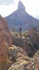
The hike took us past a shallow mine digging that had been used as a fireplace, one photo. On the other side were some craggy cliffs similar to those north of Canyon Lake and near Black Cross Butte. It was shortly after this point that we exited the wash to the left, and headed southeast up towards the spines. For me, this was the most strenuous part of the hike. The elevation incline was steep, catclaw, cactii, and other bushes more abundant, and loose rocks on some portions of the trail. Yes, I can say there is a trail because there were cairns to follow. Plus the terrain showed us where to go. It was at this point that we got our first glimpse of Aylor's Arch. Very exciting, but still a steep brush filled climb away.
At about 9:45 A.M. we reached the flat area near the west spine. It is here that the mailbox is located. We had no letters so we just signed the notebook enclosed. I wonder how often the mail is retrieved? It adds more meaning to the phrase, "The mail must go through." We spent 45 minutes up there taking photos, resting, eating, hydrating, and enjoying the awesome views. It's my first time, right? The arch cannot be seen from this spine. One must maneuver over, down, and around the second spine to get a glimpse. I just had to see . . . if I could see . . . if you see what I mean. I was slow and methodical. There were a couple of dicey spots. Okay, maybe more than a couple. I did see the arch, but, alas, from afar. No way I was ready to risk death on my first time. We all know how that turns out for me. A look was all I took. Well, I did manage to take a photo of my hiking companions above, as they took one of me. . . just in case something would happen. I climbed back to the flat area by the mailbox. There was one 4-foot rock slab that gave me some concern but I got back safely. Maybe next time!
Reed and I began the descent back down to the wash at 10:37 A.M. Ken stayed behind to continue soaking it all in. He even brought a portable stove to make some hot coffee. I took none as I was pumped enough.
The hike down was easier, as long as we did not slide due to the degree of the decline. The earlier rain helped to soften the trail and reduce the dust and loose gravel effect. We reached the wash much quicker than we did the spines going the other way. We had a choice of heading right, east, and back the way we came, or left, west, towards a low saddle and a shorter distance to the Dutchman's. So we hiked left a short distance in the wash until we came to the low point of the sloping hills, exited right and headed southwest. We found a decently worn trail with cairns to take us northwest to the Dutchman's. I believe this to be the Quarter Circle U trail I mentioned earlier in the triplog. Reed came to the Dutchman's trail first. I have a photo. There were rocks placed at the north terminus of the aforementioned Q C U. If I had my GPS I could have confirmed the coordinates. I will have to wait for my next hike on the Dutchman's to affirm my assumptions.
We arrived at the Dutchman's Trail at 11:25 A.M. taking less than 50 minutes to hike down, and we cut off about half a mile or more by NOT going back to the Black Mesa/Dutchman's junction. The hike back to the First Water Trailhead was long but easy. As we approached Parker Pass I pointed out the cairns for the unsigned Tim's Saddle Trail which heads over and down to the West Boulder Wash and the to Willow Springs, a distance of 2.5 miles. A hike for another day. I have already done it, so no first time excuses. If you miss the cairns, there is a saguaro, with a twisted arm that grows down instead of up, visible from the Dutchman's. It is a landmark indicating the Tim's Saddle trail. Just a heads up.
The two of us arrived at the FWTH at 1:00 P.M. making for a 6.5 hour hike with about 1.25 hours of downtime. The distance was about 12 miles.
Thank you for verbally travelling with me on this journey. Any comments and/or questions are appreciated.
HAPPY TRAILS!! |
| _____________________
| | |
|
|
|
|
|
| |
 Route Editor


